We provide a quick forecast update covering the threat of thundershowers Friday afternoon and accumulating snow Friday night. Read on for a discussion of the timeline and potential snow amounts.
Help support our team by subscribing to BoulderCAST Premium for less than $4 per month. If you love weather, you’ll love Premium. We promise! It truly helps support our team’s efforts to add new features and forecasting content on a daily basis, as well as growing our suite of weather instrumentation across the Front Range.
O
ur last forecast update on Wednesday set the stage for the unsettled yet uncertain stretch of weather at-hand:
From Wednesday’s forecast update: All in all, the take-away here is the extended duration of the unsettled weather. Admittedly, the timing and intensity of each individual piece of energy moving across Colorado in the coming days is not ironed-out by the models yet, not by any stretch. There is a lot of variability in regards to the specifics. However, the broad-brush of unsettled times remains the same across all model guidance.
The main reason for the short update today is that we now have increased confidence in widespread accumulating snow Friday night into Saturday morning, across both the Metro area and Foothills. We’re not talking a lot of snow, but it is something to be aware of if you are traveling late tonight or early Saturday.
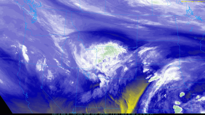
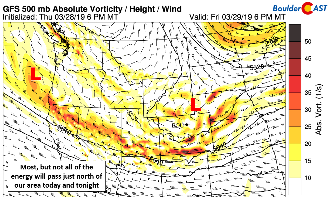
As expected, a Pacific disturbance is trekking across southern Wyoming today with most of the energy remaining north of Colorado. The storm is a lively one, but its quick progression and overall disorganization will fundamentally limit its impact across our region Friday into Saturday.
Low clouds and fog shroud the area this morning, but this should change this afternoon as the main storm system passes to our north, strengthening the drier downslope flow into the Front Range. Most models do show the low clouds eroding and then giving way to some sunshine by the afternoon hours, but it’s far from a guarantee. If clouds dissipate, highs will get into the lower 50’s. If they remain socked in, we’re definitely staying in the lower 40’s at best. Depending on how much sun we see, widely scattered rain showers and a few thunderstorms will be possible Friday afternoon and evening, mainly east of Denver though.
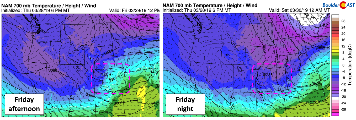
As the evening progresses, winds will turn from westerly to northeasterly across our region with the development of potent, albeit brief upslope during the overnight hours. Temperatures will drop from near 50 during the afternoon into the lower 30’s by midnight.

NAM 700mb temperature and wind forecast for this afternoon (left) and tonight (right). The shift from downslope to colder upslope is evident.
This upslope combined with strong frontogenesis and interplay with the upper-level jet will lead to a period of moderate lift across most of the Metro area tonight. Based on relatively good agreement between most of the models, we’re expecting between 0.25″ and 0.5″ of liquid by sunrise Saturday, possibly a little more if you believe the more bullish Euro model. A good chunk of this will be wet snow falling on a warm ground.
Our concerns throughout the week for this system’s potential to produce accumulating snow were temperatures (both of the ground and the air) and snowfall rates. Given the lift and fetch of Gulf of Mexico moisture, snowfall rates could near 1″ per hour in some areas through the overnight hours, enough to counter and overwhelm the melting potential and produce a few inches of accumulation region-wide. The complete night-time occurrence of this event is also a blessing in disguise for accumulating snow.
Here’s the latest timeline for the event:
- Dreary Friday morning with fog and drizzle.
- Some sunshine possible Friday afternoon if downslope flow erodes the low clouds. Highs lower 40’s to lower 50’s, dependent on sunshine.
- Widely scattered showers and a few thunderstorms develop late Friday afternoon into the evening.
- The “meat and potatoes” of the storm arrive between 8PM and midnight with rain quickly changing to wet snow, which could be heavy at times.
- Snow continues through the overnight hours, tapering off from north to south early Saturday morning. Snow will be heaviest between 8PM and 4AM.
- Low clouds Saturday morning will lift, with overcast skies through the day. Highs temperatures stay cool in the upper 30’s to lower 40’s.
- Temperatures remain near or slightly below normal through early next week with a slight chance of rain/snow every 24 to 48 hours. The pattern is active, but any storm systems will be fairly disorganized.
Our official snowfall forecast map:
And finally, the latest Snowfall Probabilities:
The fact that ground temperatures are so warm (40 to 45 degrees as of Friday morning) will limit the travel impacts across the region. Roads will likely remain just wet or slushy through the night-time hours, except in the Foothills where temperatures will be colder. Snow accumulation across the Metro area will primarily be confined to the grass and elevated surfaces.
Have a good weekend! We’ll be back on Monday with our usual weekly outlook.
Spread the word, share the BoulderCAST forecast:


You must be logged in to post a comment.