
In typical late-March fashion here in Denver, this week’s forecast will blur the line between the spring and winter seasons. While temperatures will soar to their warmest thus far in 2019 by mid-week, we are watching a storm late in the week that could bring significant rain and snow to the Front Range.
T
his week is the first full-week of the spring season and it will definitely feel like it! Several mid-level ridges have consolidated across western North America over the last few days, with the primary ridge axis located to our west across Utah this morning.

As always, with the axis still to the west, northwest flow remains in control across Colorado. It’s not until Tuesday and Wednesday with the ridge axis passing eastward that we’ll start seeing the warmer southwesterly flow push across the state. Once this happens, though, temperatures will really begin to SOAR!

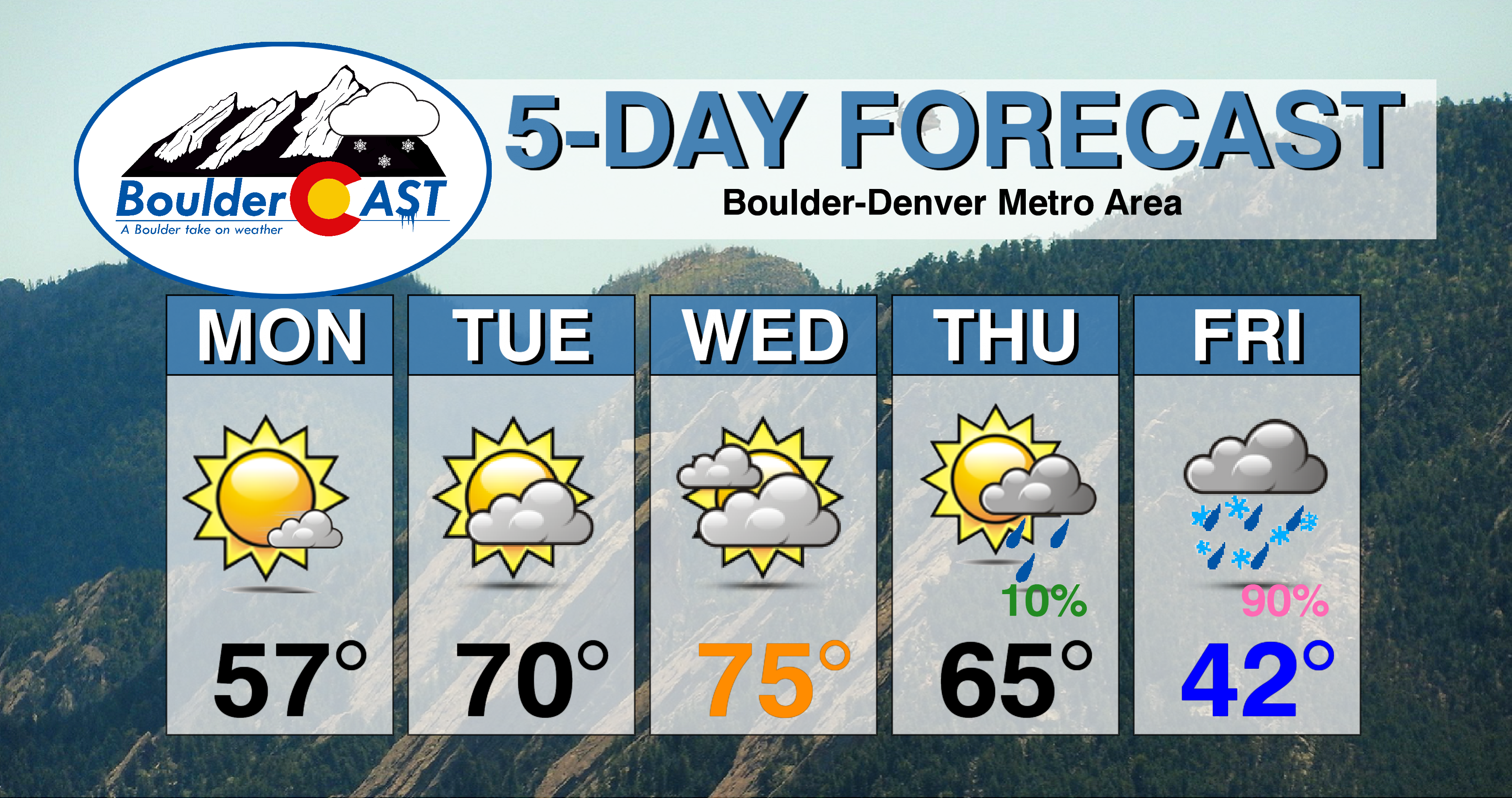
Alongside dry weather, the trend through mid-week will be increasing clouds and warming temperatures. We’re expecting highs in the Denver Metro area to push into the upper 50’s on Monday, then to near 70 on Tuesday, and then into the middle 70’s on Wednesday. The record high for March 27th is 78 degrees in Boulder. We do have a slight chance to surpass this on Wednesday!
Late week: Will it be rain, or will it be snow?
It’s not all pleasantries in the forecast this week. Let us not forget that the FIRST full-week of spring also happens to be the LAST week of our snowiest month of the year… We are indeed tracking a storm for late in the week that has the potential to rain (and possibly snow) on our spring parade. The storm in question can be seen above off the coast of the Pacific Northwest. This disturbance will elongate and then track eastward into Colorado later this week.
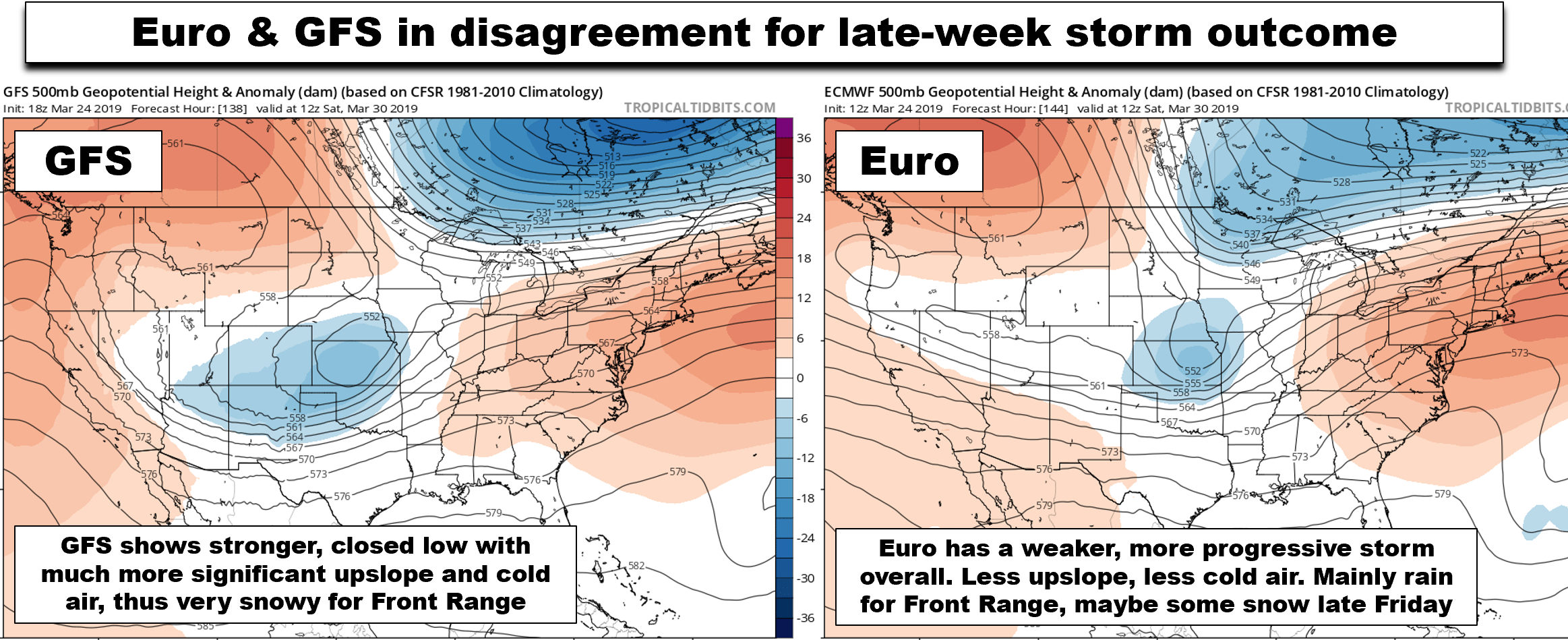
Keep in mind that we are still a solid FOUR TO FIVE days out from this one, and as you might expect, the models are still fiercely debating the outcome for our region…
If you’re craving a good ol’ fashioned Front Range spring snowstorm, you should be rooting for the GFS model. The GFS is leaning VERY strongly right now towards a potent closed-low, with deep moisture and cold air wrapping into northeast Colorado Thursday night through Friday night (see below). The Euro model is showing a fairly decent storm as well, but nothing as strong, or as cold as the GFS. This leads to the Euro predicting a mainly rain event for the Front Range, with possibly significant snow just to the west in the Foothills.
Most of the current model guidance suggests precipitation amounts between 0.5″ and 1.0″ for the Metro area are possible, if not likely by the end of the week. The primary concern at this time surrounds those always tricky late-March temperatures. Will it be rain or will it be snow?
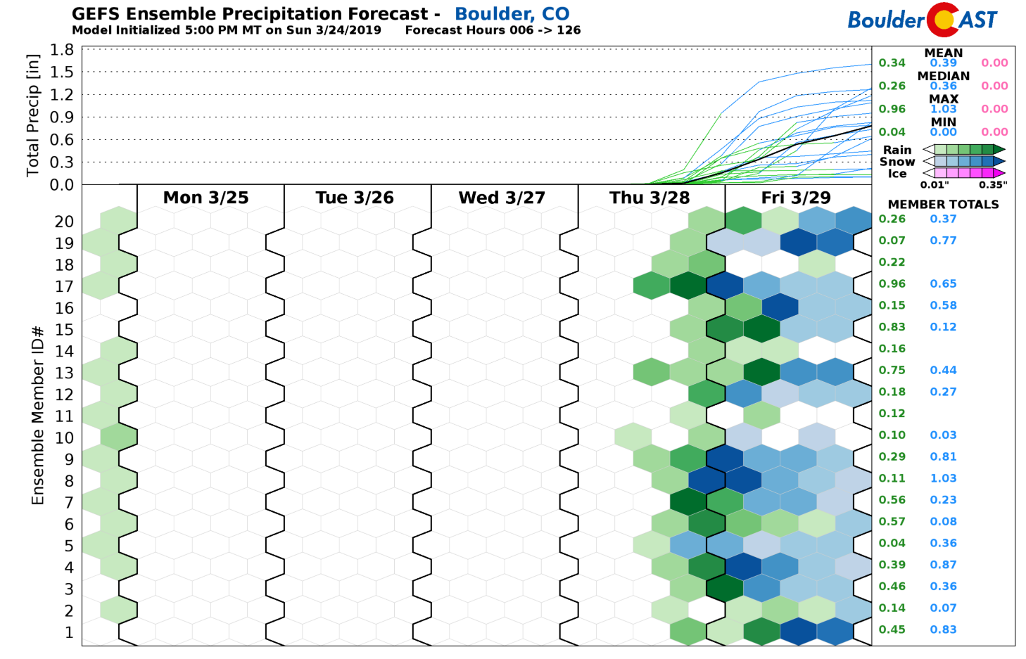
Our gut-feeling at this time is that we won’t escape this storm without seeing at least SOME snow. It remains to be seen whether it ends-up being a lot of snow (per the GFS), or just a little towards the tail-end of the event (per the Euro). Our latest batch of snowfall probability charts show low-end odds of snow amounts up to 8″ in Boulder and Denver. But keep in mind we also see only 70% odds of reaching 1″ of snow. There is definitely the possibility that warm temperatures could keep things mainly rain for the lower elevations. The chance of heavy wet snow in the Foothills is looking quite good, though.

We’ll definitely be monitoring this system through the week, so do check back for updates (or subscribe to our email list).
We respect your privacy. You can unsubscribe at any time.
For now, plan on another pleasant day Thursday with increasing clouds and temperatures still quite warm in the 60’s. It’s not for certain, but we could see some rain showers develop late in the day Thursday, though we suspect these will hold off until the overnight hours.
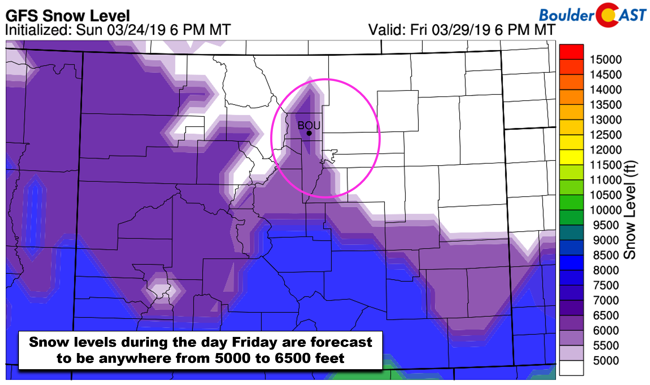
Things will likely trend downhill Thursday night and early Friday as the upper-level storm approaches. It begins with a cold front moving into northeast Colorado and upslope developing behind it. Rain showers will likely be widespread through the day Friday and into Friday night, with snow in the Foothills. If the GFS verifies, we’ll be seeing some wet snow across the lower elevations as well. Highs Friday will be chilly in the upper 30’s to middle 40’s.
All in all, Friday is shaping up to be quite unsettled, whether it be rain or heavy wet snow, we’re in for a dreary spring storm. Stay tuned…
Forecast Specifics:
Monday: Morning low clouds, then sunny and mild with high temperatures in the upper 50’s across the Plains and in the upper 40’s in the Foothills.
Tuesday: Partly cloudy and warmer with highs near 70 degrees across the Plains and in the upper 50’s in the Foothills.
Wednesday: Partly to mostly cloudy and the warmest day of the week. Highs in the mid 70’s on the Plains and low 60’s in the Foothills.
Thursday: Warm early with increasing clouds through the day. Isolated rain showers developing in the evening, become more widespread overnight. Highs in the 60’s to lower 70’s on the Plains and in the 50’s in the Foothills.
Friday: Overcast and soggy with rain or wet snow probable throughout the day. Potential snow amounts are uncertain at this time for the Plains, but more than 6″ is possible in the Foothills. Highs in the upper 30’s to lower 40’s on the Plains and in the 20’s in the Foothills.
High Country: Monday through Thursday morning will be dry with very warm temperatures statewide. Expect the snowpack to take a sizable hit through Thursday. As the late-week storm approaches, some rain/snow will be possible across the Mountains Thursday evening through Friday evening. Though most of the moisture and best forcing will be confined to east of the Continental Divide. Check PowderCAST for updated forecasts for all the Colorado ski resorts.
DISCLAIMER: This weekly outlook forecast was created Monday morning and covers the entire upcoming week. Accuracy will decrease as the week progresses as this post is NOT updated. To receive daily updated forecasts from our team, subscribe to BoulderCAST Premium.

.
Share our forecast!


You must be logged in to post a comment.