Over the last few days, weather models have shifted a few degrees warmer for the incoming spring storm. We discuss the implications and provide our preliminary snowfall forecast map.
STORM INGREDIENTS
We’ve been closely monitoring the approaching spring storm for nearly a week now. The weather models have remained largely consistent since Monday, with just minor wobbles in the storm’s track, generally trending things slightly further southward over time. At the moment, this minor southward migration isn’t an issue for us, but we are now a little closer to the northern fringe of the heavier precipitation and the best upslope.
As of Thursday morning, the system is located near Reno, Nevada. The storm will slowly move eastward over the next 48 hours across extreme southern Colorado, ejecting into Oklahoma by Saturday night. The GFS 500 mb map below shows the position of the cut-off low Friday evening over south-central Colorado. The European model has a very similar track, but with the storm lagging several hours behind. If you’ve been following with us for a few years, you know this track is near the “sweet spot” for Front Range spring storms.

GFS 500 mb vorticity forecast map for Friday evening at 6:00 PM.
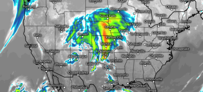
This positioning will put our region in a reasonably favorable location for large-scale lift and upslope to overlap beginning Friday afternoon. There will be about a 24-hour window for precipitation to occur while these forcings coincide. The GFS precipitable water map below shows the pipeline of Gulf of Mexico moisture that will be flowing northward into eastern Colorado and western Kansas Friday evening.

GFS precipitable water forecast for Friday evening showing the Gulf of Mexico moisture advecting northward into the storm.
Note that the core of the moisture will be closer to the Kansas border. It’s in far eastern Colorado that convective thunderstorms, some of which could be bordering on severe, are expected to form Friday afternoon and early evening. This brings up yet another challenge in forecasting these springtime storms. Those thunderstorms in the warm sector of eastern Colorado, depending on how widespread they are, can eat-up the available moisture before it even reaches the Front Range (being removed from the atmosphere as heavy rainfall). The net result from this can be drier air in our region and less overall precipitation potential. Earlier in the week, models were indeed showing more moisture wrapping into the Metro area. Still, given the forcings at play, the 0.5″ of precipitable water this time of year is plenty to produce a decent precipitation event.
RAIN OR SNOW?
Earlier in the week, we were optimistic about this storm having the potential to bring heavy wet snow to the Metro area. Though, full disclosure, meteorologists are always optimistic about that, even during the summer months! Our good wishing did not help in the end…
The graphic below shows the evolution of 700 mb winds and temperatures across Colorado Friday evening into Saturday. Initially on Friday afternoon, temperatures will be warm across the region, likely in the upper 40’s to lower 50’s on the Plains, with southeasterly flow at 700 mb (top left panel). This will be pumping moisture into the region, but southeasterly flow is also (relatively) warm. As a result, except for the highest Foothills, precipitation will begin as rain Friday afternoon. A cold front is expected to move into northeast Colorado Friday evening with snow levels dropping and deeper northeasterly upslope setting-up across the Boulder/Denver area.
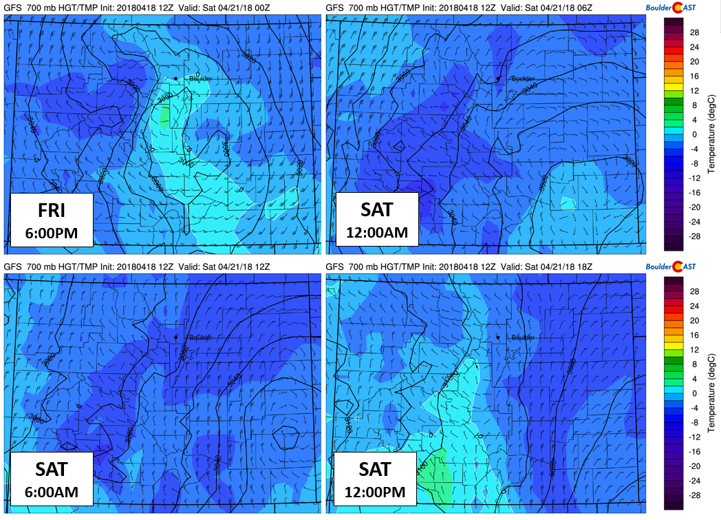
GFS 700 mb temperature and wind forecasts for the duration of the storm. Southeasterly flow turns northeasterly late Friday evening, with colder air filtering in as well.
Snow levels will begin high-up Friday afternoon, near 8500 feet or so, but will drop Friday evening into early Saturday as cooler air arrives from the north. The question then becomes a matter of HOW LOW WILL THEY GO? If there has been one noticeable trend in the models over the last few days, it has been one of warmer overall temperatures. An animation of the last few runs of Saturday morning’s near-surface temperatures from the Euro is shown below. In the last few days, model temperatures for the storm overall have warmed about 5 degrees Fahrenheit…not great for those hoping for snow!

European ensemble mean 850 mb temperature anomaly for Saturday morning. The loop shows model runs from Sunday (Apr 15) through Wednesday (Apr 18). Focus on eastern Colorado and notice the warming trend over time.
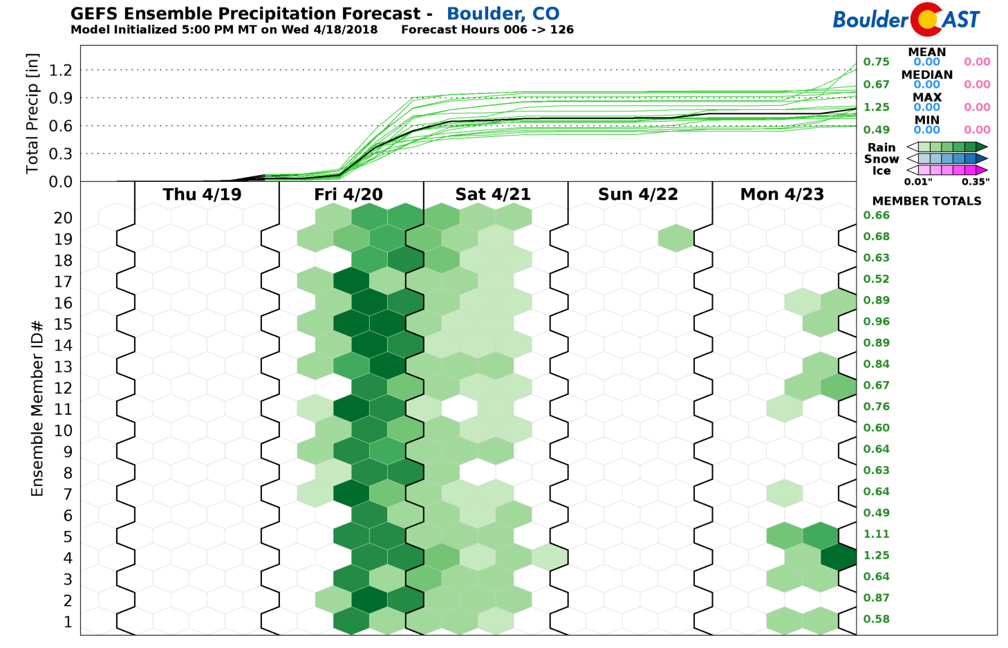
As such, both the GFS and European models have temperatures running too warm for ANY snow accumulation across the Plains, bottoming out between 35 to 38 degrees Friday night. We’re seeing this same motif carried over in their respective ensembles as well. The GFS doesn’t have a single forecast member cold enough for snow in Boulder right now (see below)…nothing but green.
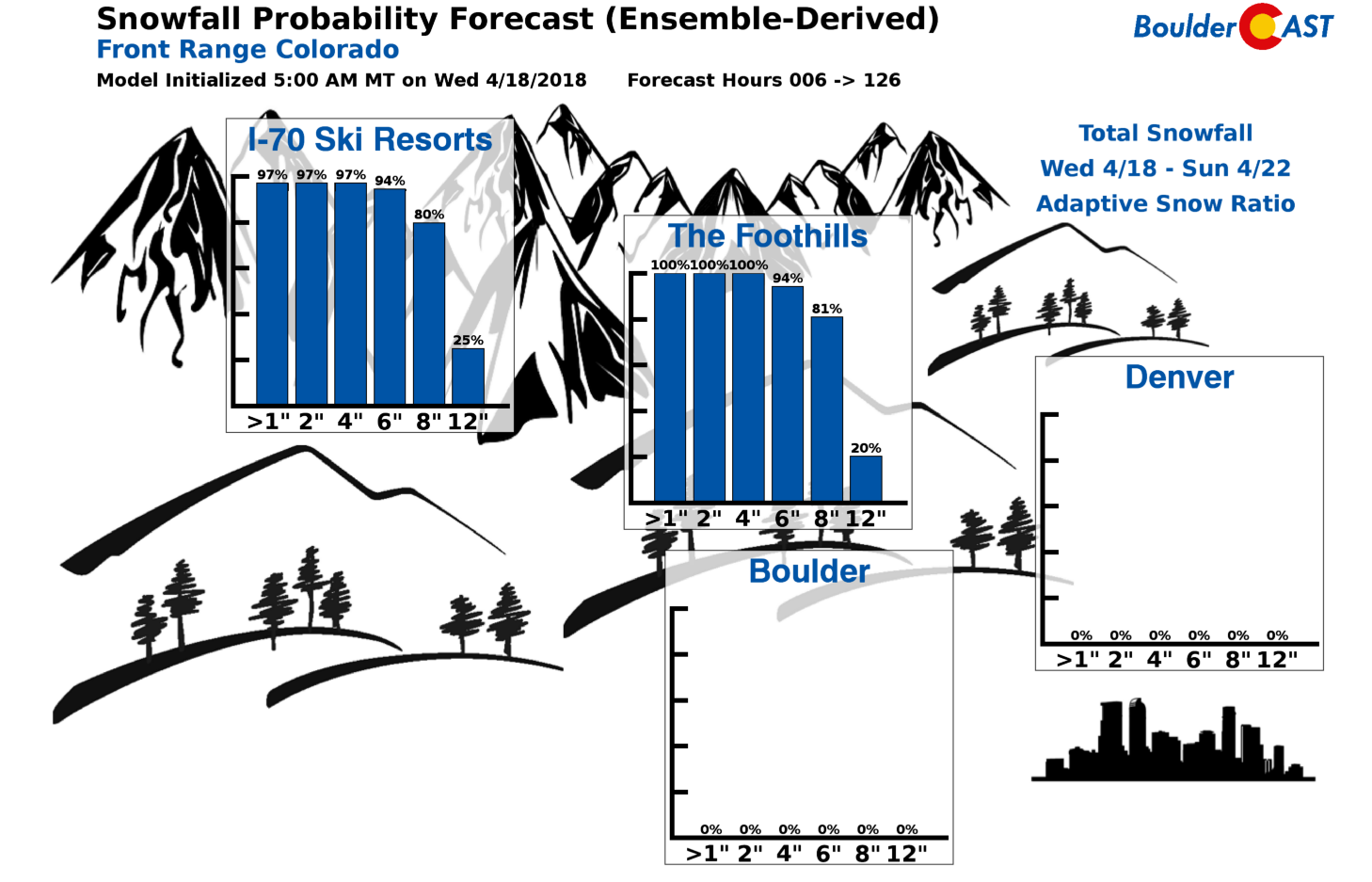
Our Snowfall Probability Charts reflect this rainy forecast just the same with zero percent chances across the board in Boulder and Denver. Despite this, in the higher elevations, more than 8″ of snow is looking like a safe gamble.
We do want to mention that one outlier is the NAM model which is coming in MUCH colder at the moment (see below) which produces several inches of wet slushy snow for the Metro area late Friday night and early Saturday. While the potential for snow across the lower elevations bears watching, at this time, we are expecting just a cold rain for everyone below ~6000 feet. Our thoughts are that the NAM is way off-base.

Model-derived snow level forecast for Saturday morning from the GFS (left) and NAM (right) models. There is a big difference in temperatures across the Front Range.
Rain and snow will begin to taper off late Saturday morning into the afternoon hours as the storm system pulls eastward and drier northwest flow spreads across the Front Range.
AMOUNTS
There is still a good bit of variation in the models on exactly how much precipitation falls across the Metro area, but we do have a good idea on the range of possibilities. With upslope such a vital component, the highest precipitation totals will be in and near the base of the Foothills.
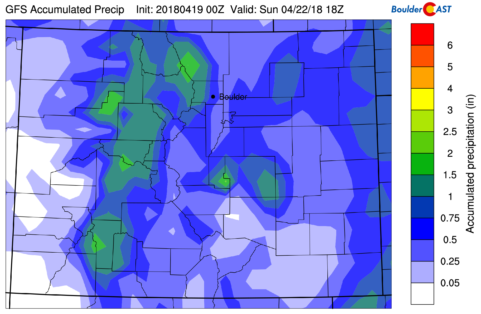
Here is what the latest GFS model has for precipitation totals…0.5 to 1.0″ with higher amounts in the Foothills.
And here is the Euro…very similar, but with a focus of 1″+ across the western Metro area.
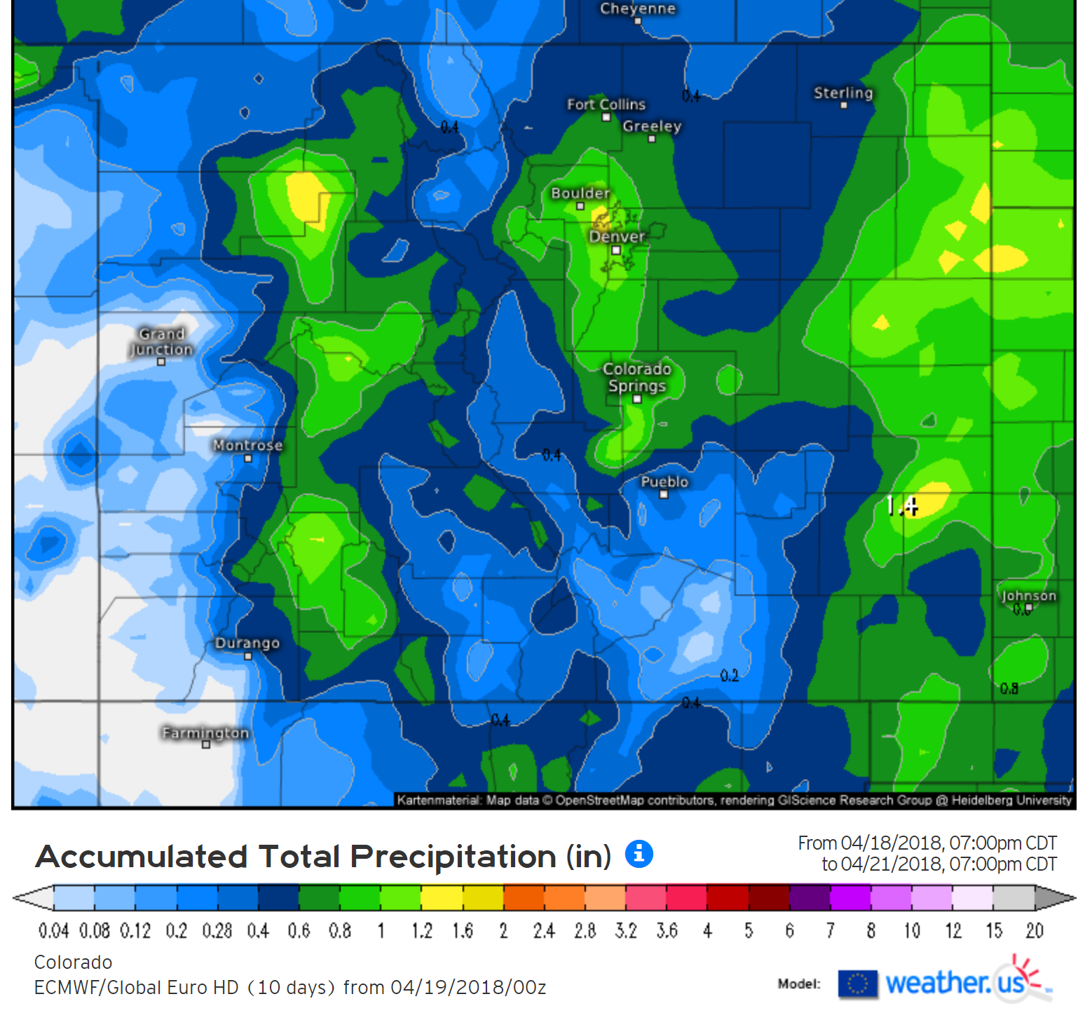
Most locations across the Front Range should fall in the 0.5 to 1.0″ range for precipitation by Saturday afternoon, a wealth of much needed moisture for everyone! This will be all rain for the Plains. The Foothills could see totals closer to 1.5″ of liquid, which would be falling as snow above 8,500 feet. With the snow level in flux between 6000 and 8500 feet elevation, these locations have a tough snowfall forecast and will see a mixture of rain changing to wet snow (and maybe back to rain at the end of the event). This facet of the forecast is reflected in the tight gradient in snow amounts just west of Boulder, which is shown in our preliminary snowfall forecast map below:
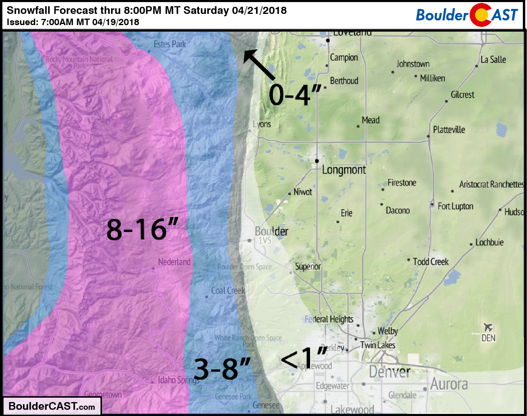
NOTE: We will likely update this forecast map Friday morning to fine-tune the ranges to be less ambiguous, dependent on what the next few model runs show.
The less than 1″ snowfall forecast for the western and southern Denver Metro area covers areas that COULD see a few snowflakes if temperatures end-up a degree or two colder that what a majority of models are showing currently. The Metro as a whole is looking at just a chilly, soaking rain.
Travel into and through the higher Foothills and Mountains Friday afternoon into Saturday morning will be treacherous. It’s your call if that 8-14″ of powder is worth it. Do be careful if you are heading out!

PowderCAST ski forecast for Friday
Don’t forget, our 3-year anniversary sale ends Friday at midnight:
Join our email list:
As a BoulderCAST email subscriber, you will get:
- Instant email notifications for all of our storm updates, forecasts, and posts
We respect your privacy. You can unsubscribe at any time.
Share this forecast:
.


You must be logged in to post a comment.