Colorado’s monsoon season has been off to a sluggish start, and the latest surge storm potential this week isn’t even from the monsoon itself—it’s thanks to potent cold fronts dropping in from the northeast. In today’s update, we dig into why flash flooding is on the rise this week, which areas are most at risk, and what the next few days could mean for our thirsty landscapes. Spoiler: while heavy rain is possible, it’s only a short window and many of us won’t see it. Plus, the new blanket of wildfire smoke is likely to stick around through the weekend.
At a Glance:
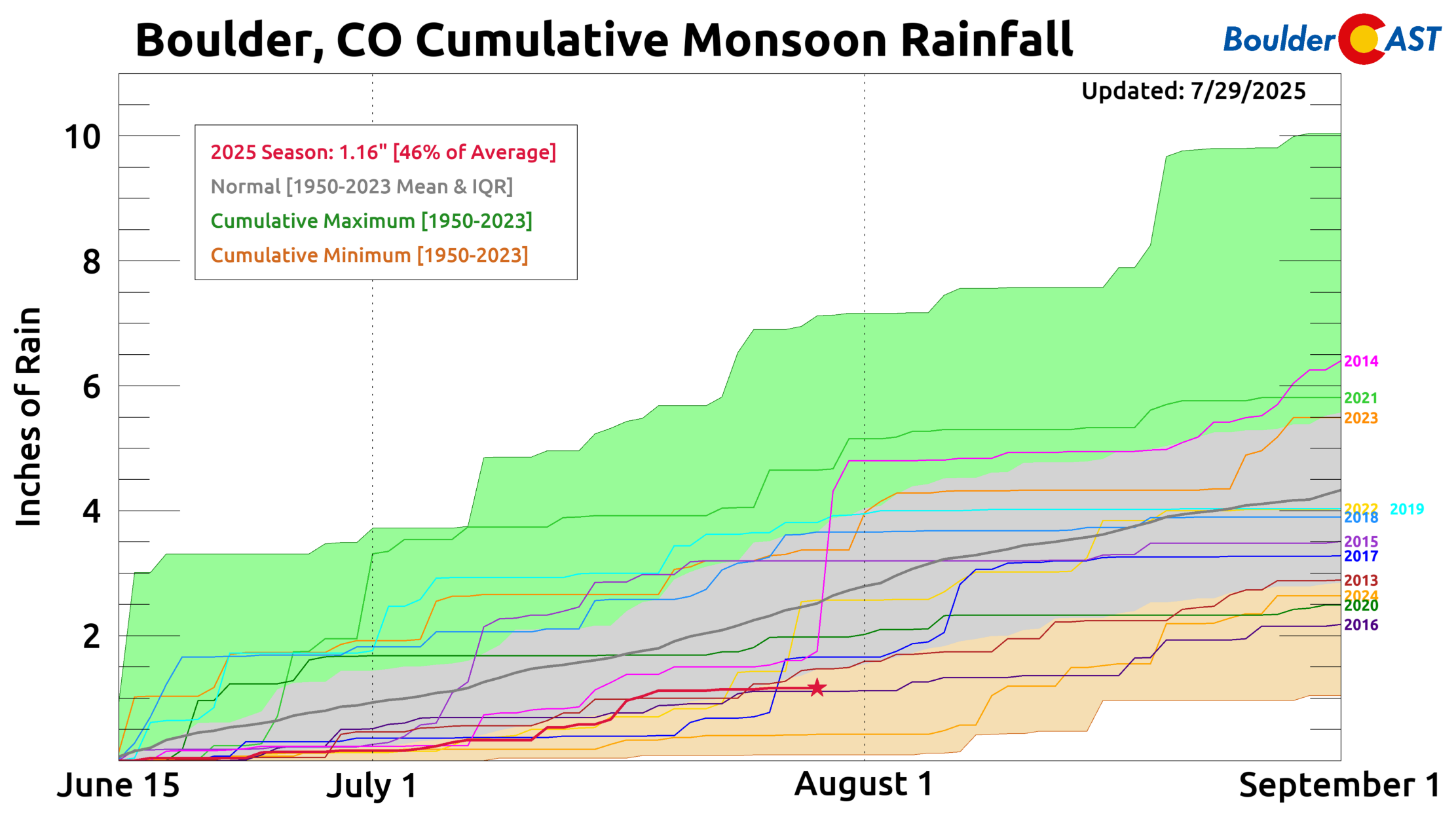
- Monsoon Letdown: The 2025 Summer Monsoon has underperformed across Colorado, with Boulder receiving just 1.16″ of rain since mid-June—less than 50% of average. Denver has seen even less.
- Cold Fronts Driving Rain: Upcoming storm chances stem from two strong cold fronts, not directly from monsoon flow. These fronts brought unusually humid air and elevated moisture levels.
- Flash Flood Risk Rising: Historically, late July and early August mark our peak flash flood season—especially with weak steering winds. Precipitable water levels will exceed 1″, triggering slow-moving storms with potential for heavy rainfall. NOAA has issued a Slight Risk for flash flooding through Thursday for our area.
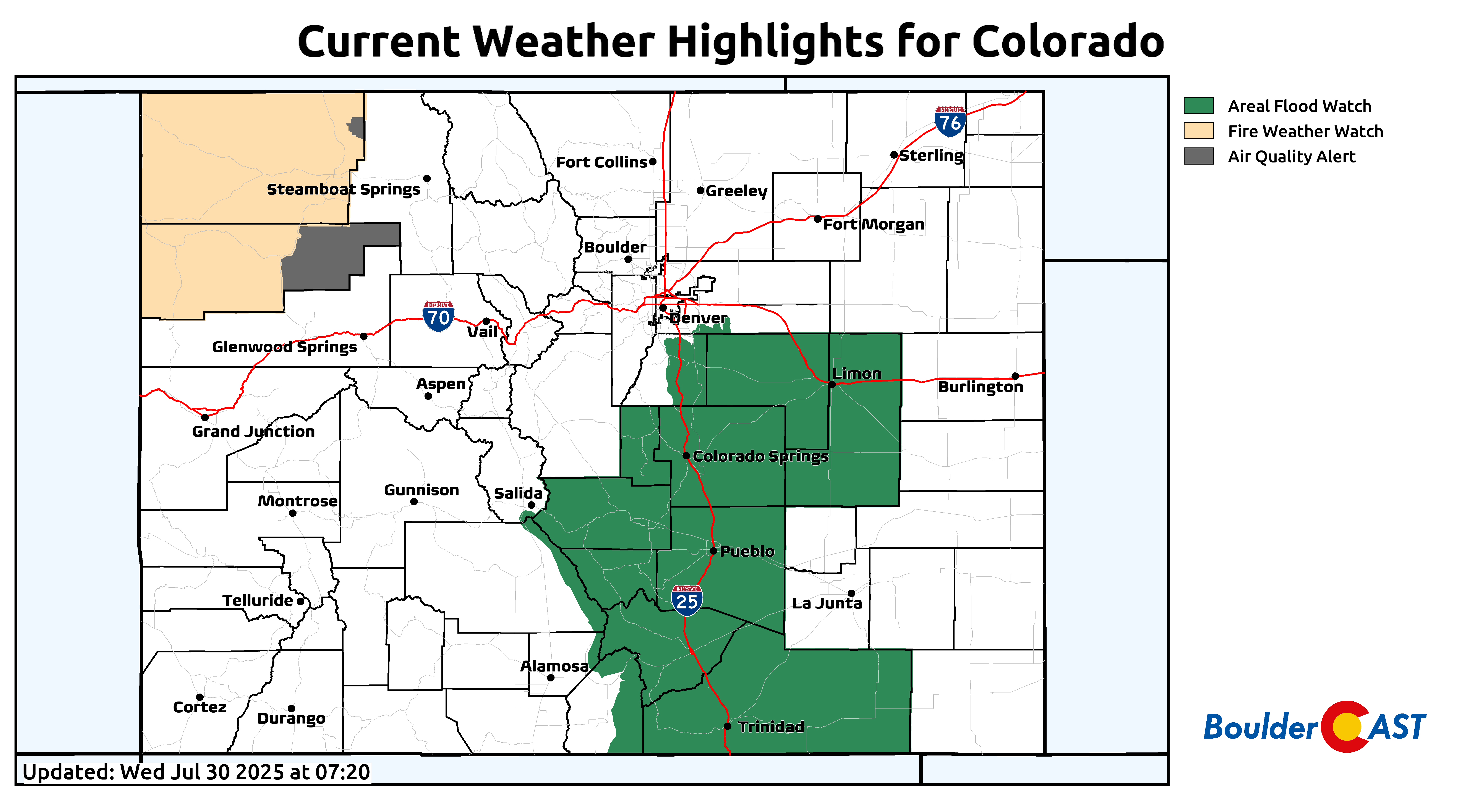
- Highest-Risk Zones: Burn scar regions and already-saturated areas southeast of Denver are most vulnerable. Flash Flood Watches are posted in southern Colorado.
- Severe Threat Too: A low-end risk of severe storms will exist for the area Wednesday and Thursday as well.
- Extended Outlook: Moisture Wanes as Smoke Thickens: Elevated rain chances taper off after Friday with the extended looking hot and mostly dry. Smoke from western wildfires will linger across Colorado through the weekend.

Go Premium, get all the perks.
Daily Forecast Updates
Get our daily forecast discussion every morning delivered to your inbox.
All Our Model Data
Access to all our Colorado-centric high-resolution weather model graphics. Seriously — every one!
Ski & Hiking Forecasts
6-day forecasts for all the Colorado ski resorts, plus more than 120 hiking trails, including every 14er.
Smoke Forecasts
Wildfire smoke concentration predictions up to 72 hours into the future.
Exclusive Content
Weekend outlooks every Thursday, bonus storm updates, historical data and much more!
No Advertisements
Enjoy ad-free viewing on the entire site.
2025 Summer Monsoon: Where’s the Rain?
It’s been a pretty lackluster monsoon season so far across Colorado, and the Front Range hasn’t been spared. Over the last month, the Denver Metro has picked up only about half its typical rainfall. That’s taken a toll on our vegetation, and unfortunately, fire danger is creeping upward.
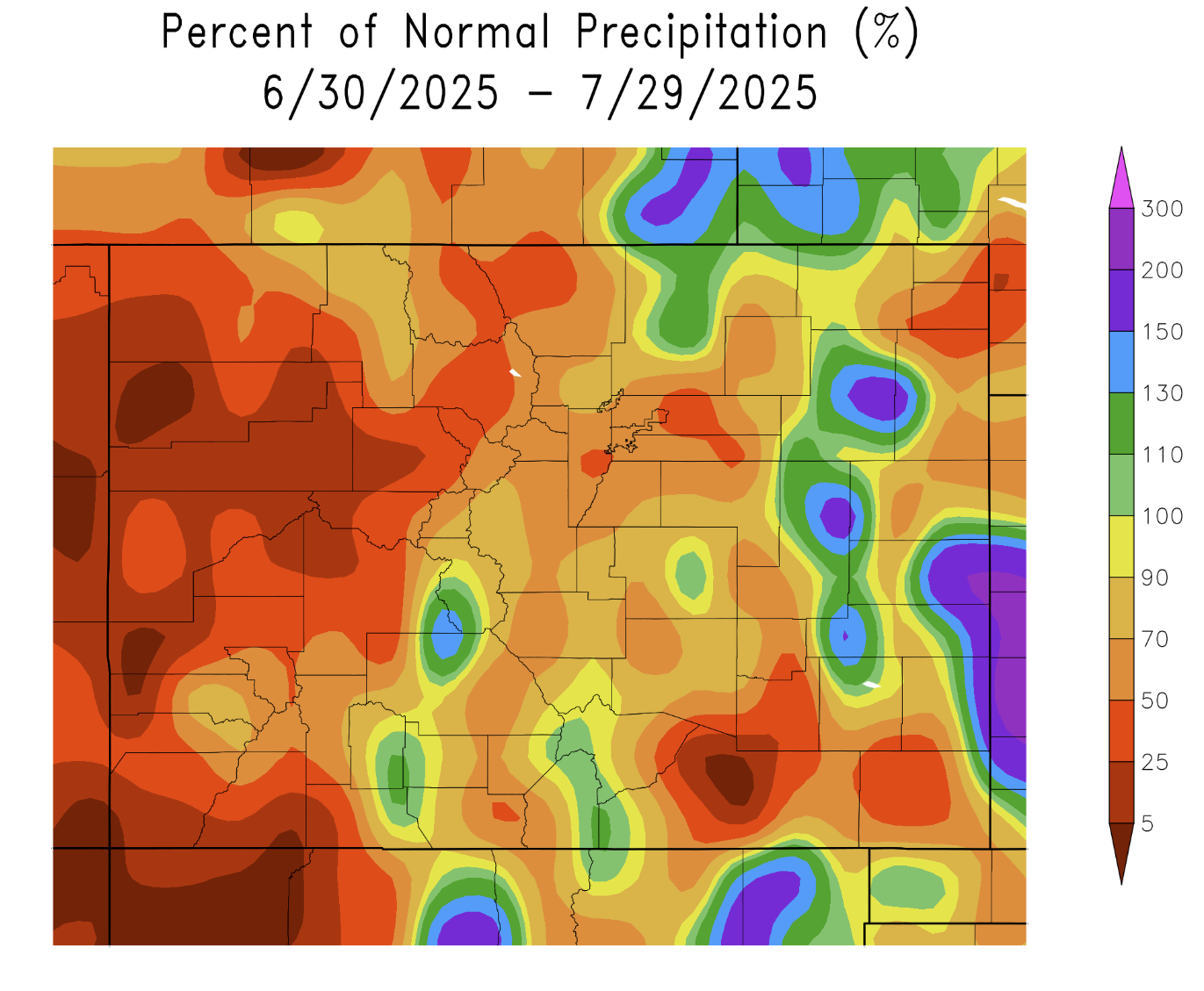
Since mid-June, Boulder has only seen 1.16″ of rain. That’s less than 50% of normal, placing this monsoon season squarely in the driest quartile of data since 1950. Not exactly the soaking summer we’ve needed.
Heavy Rain Potential & Flash Flood Risk This Week
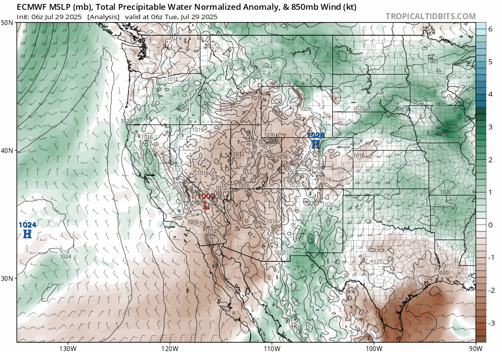
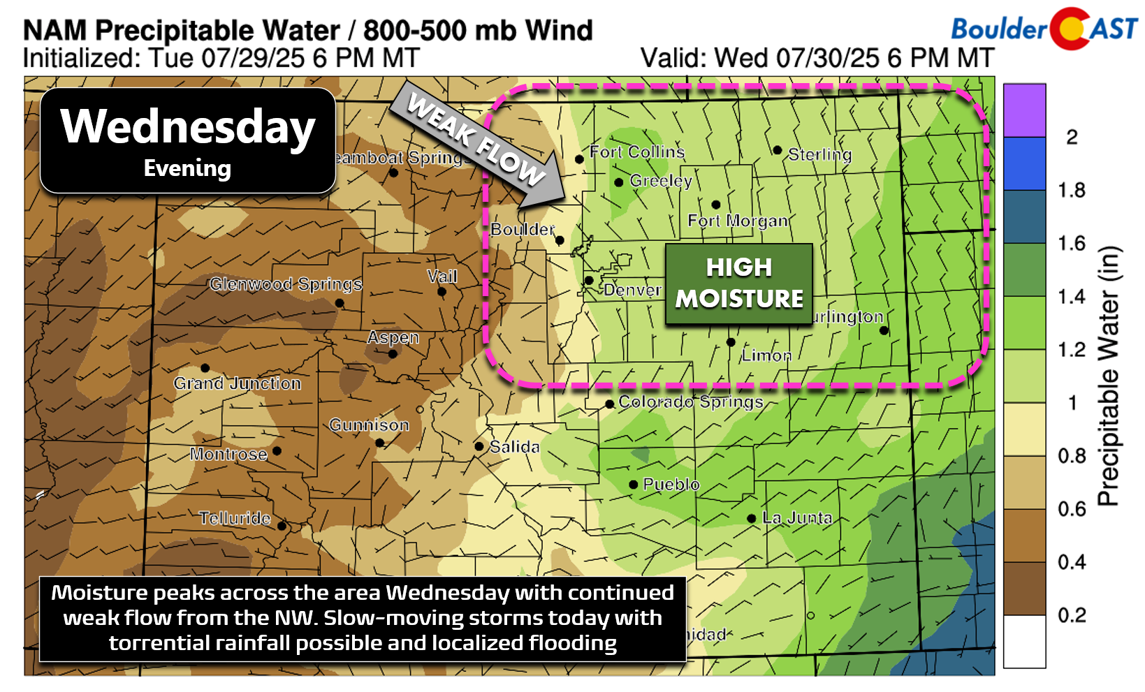
While rain is in the forecast this week, it’s not thanks to the usual summer monsoon flow. Instead, two unusually strong cold fronts pushed south across eastern Colorado and are stirring things up. The first front brought some sticky air with it—dew points hit the mid 60s on Tuesday, which is rare around here and definitely was noticeable.
According to the latest precipitable water anomaly data, monsoon moisture is staying mostly south—in New Mexico and far southeast Colorado. Meanwhile, moisture reaching us is actually coming from the northeast, riding in behind those cold fronts. Through Friday night, we’ll see above-average moisture lingering over the Front Range, meaning rotating chances for afternoon and evening storms through the workweek.
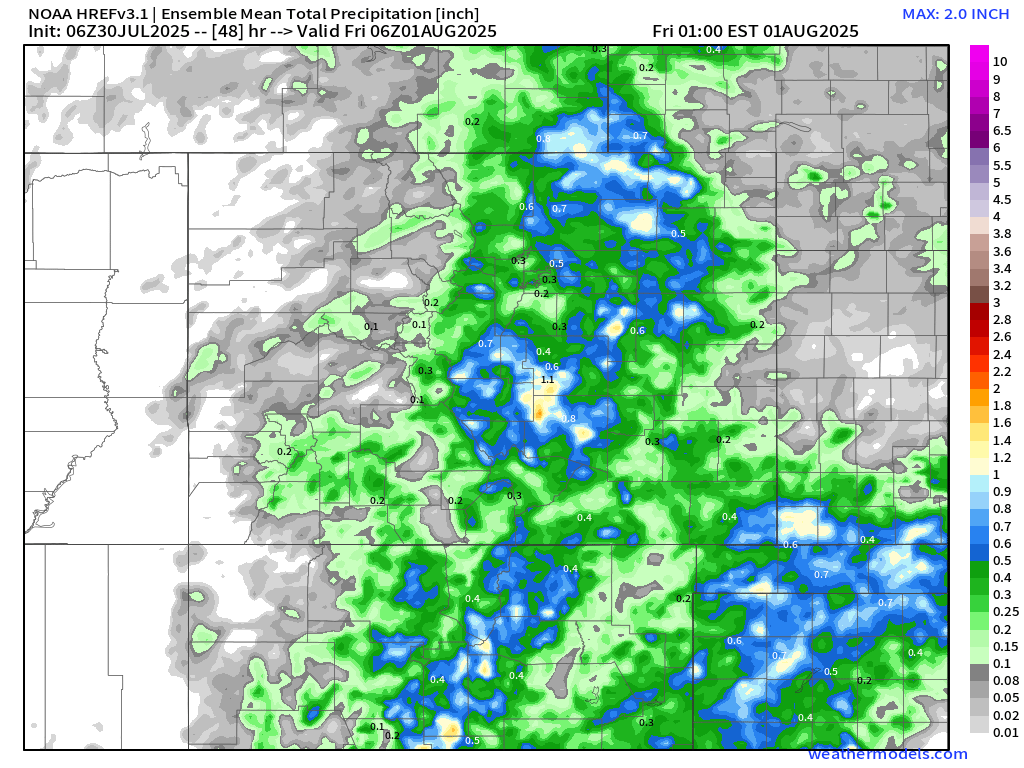
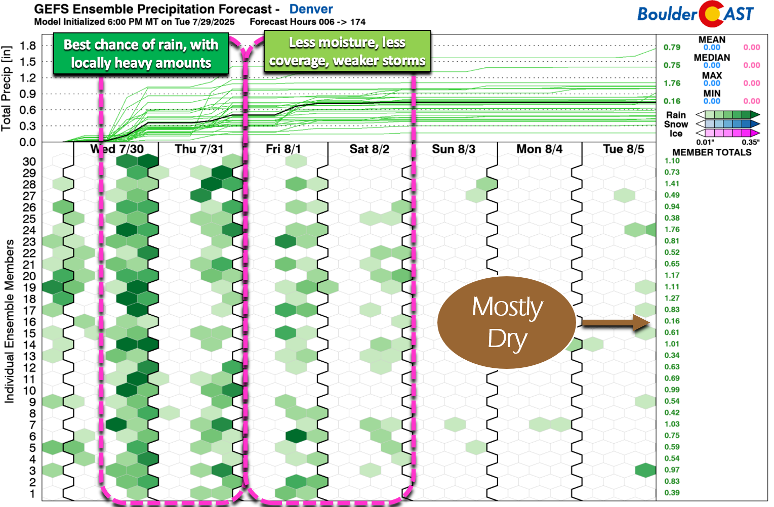
Precipitable water levels are forecast to climb above 1″ for both Wednesday and Thursday in the Boulder–Denver area. Storms will likely be slow-moving, which means any downpour could lead to localized flash flooding.
High-resolution convective models are hinting that a few lucky spots could see 1–2″ of rain through Thursday night, though most areas will end up with less than half an inch. Still—every drop helps.
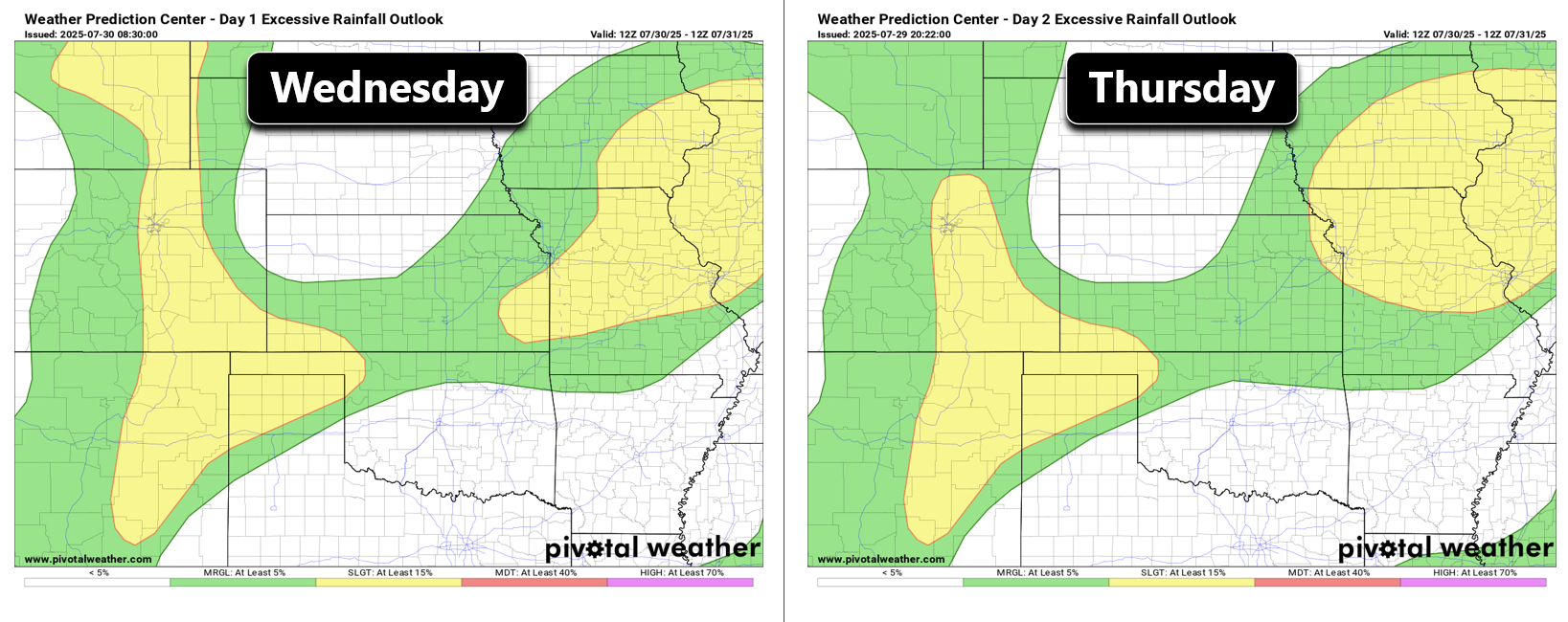
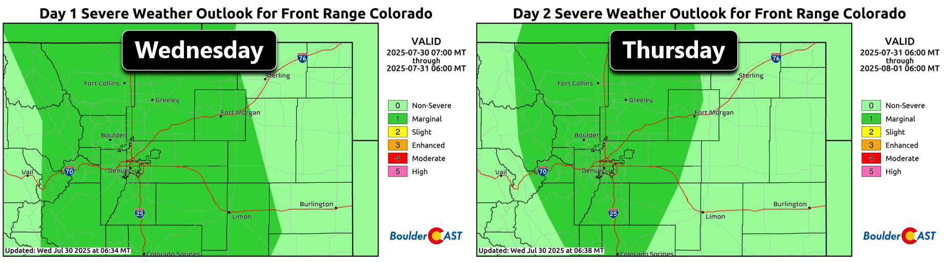
The NOAA Weather Prediction Center has flagged the Denver Metro and nearby Foothills with a Slight Risk for Excessive Rainfall Wednesday and Thursday. That translates to a 15% or higher chance of flash flooding within 25 miles of any given point.
Here’s where flash flooding is most concerning:
- Burn scar areas in the Mountains and Foothills east of the Continental Divide (e.g. Cameron Peak, East Troublesome, Calwood). If you’re downstream, stay alert to any flood warnings.
- Southeast Colorado, where soils are saturated from recent rain—Areal Flood Watches are active for these zones.
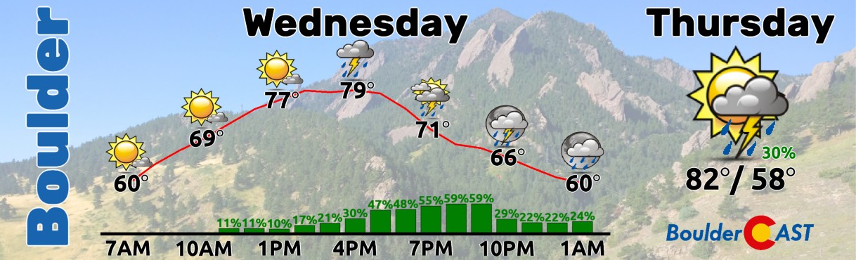
Wednesday and Thursday will unfold similarly across the area. Expect storms to develop over the higher terrain during the early afternoons, with rain spreading eastward through Boulder and Denver during the late afternoon and evening hours. Rain chances will be around 60% both days with highs close to 80 degrees. Heavy rain, lightning, hail and flash flooding are all on the table.
Why Flash Flooding Usually Peaks This Time of Year
Late July into early August is historically the prime window for flooding in the Front Range. Weak upper-level winds caused by high-pressure ridging aloft, combined with monsoon moisture, can lead to slow-moving torrential downpours. Add in summertime cold fronts, like we have this week, and the risk can tick even higher.

Diagram credit: Baker of NWS Boulder
Not surprisingly, some of the worst floods in state history have occurred in late July and early August. The Big Thompson Flood of 1976, the deadliest flood in Colorado’s history, occurred on July 31st, and more recently, on August 10, 2013, heavy rain triggered flash floods and mudslides west of Colorado Springs. The flooding risk doesn’t shut off after August either. September can still pack a punch—just ask anyone who remembers the September 2013 flood.
An Accompanying Severe Risk
While flash flooding and severe storms might seem like two sides of the same weather coin, they actually need different atmospheric setups to thrive. For severe hail and strong wind, you’re looking for colder cloud tops that support hail growth and decent wind shear aloft to keep storms organized. On the flip side, flash floods favor deep, warm clouds and very weak steering winds—so storms can park in place and unload.
In the coming days, conditions will be kind of in-between. We’re not seeing the full recipe for either high-end flooding or severe weather, but there’s just enough instability to nudge both risks into play simultaneously. Mid-level cloud temperatures and sluggish (but not totally stagnant) winds aloft mean we could still see a few pop-up storms with 1″ hail and gusts to around 60 MPH on Wednesday or Thursday.
Looking ahead: Rain declines as smoke thickens
Starting Friday, moisture levels drop and rain chances retreat, giving us a pretty dry extended outlook. So the next couple of days might be our best shot at beneficial rainfall.
One final note: thick smoke from large out-of-state wildfires burning will be blanketing most of Colorado throughout the extended. The biggest fires of concern right now are the Dragon Bravo Fire in Arizona (95,000 acres and 9% containment) and the Monroe Canyon Fire in Utah (37,000 acres and 11% containment). Smoke from these fires is already over Denver as of Wednesday morning creating hazy skies.
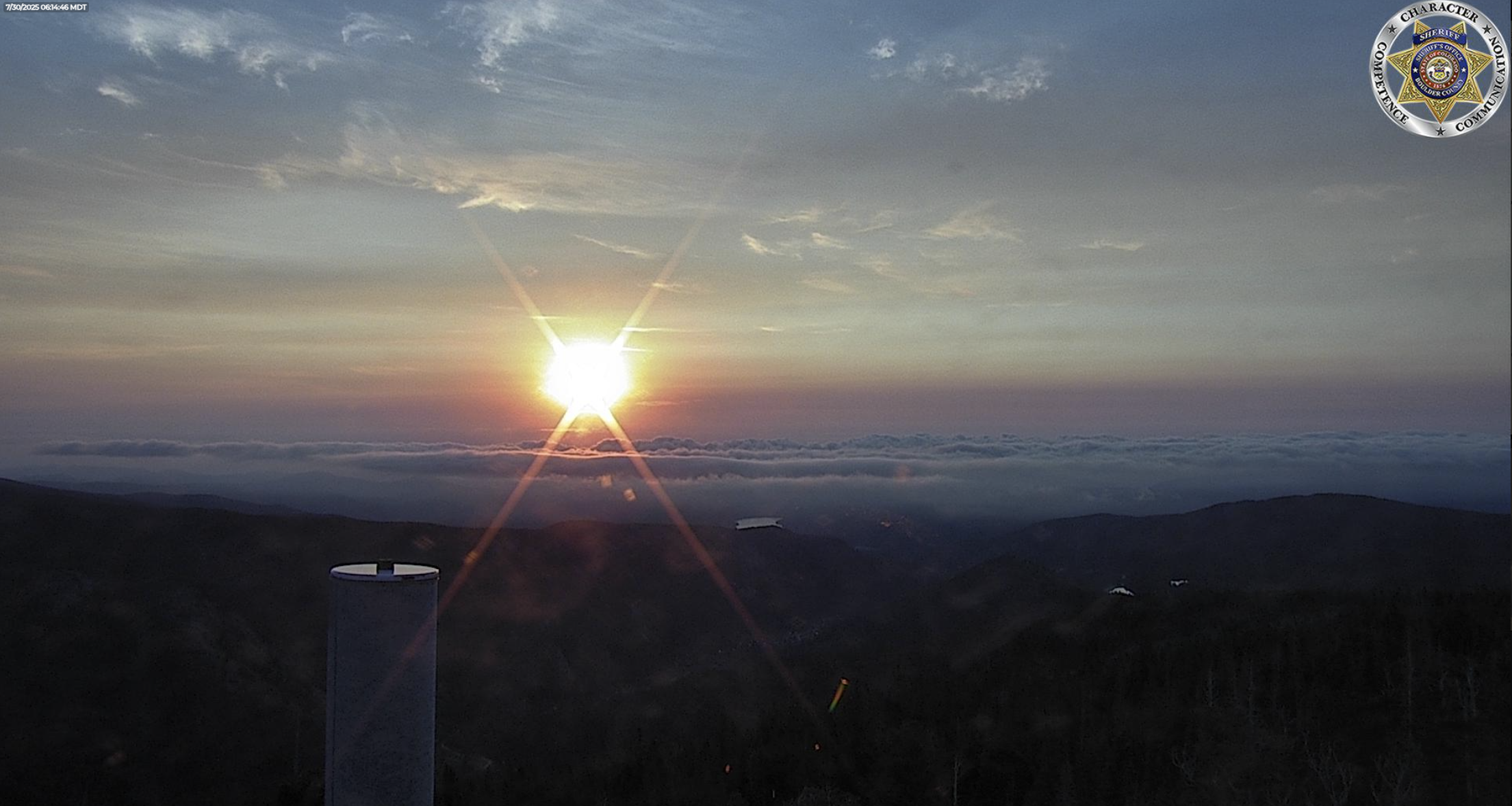
Smoky view looking east from Eldora early Wednesday morning. Note also the stratus clouds, compliments of the overnight cool front
The smoke is expected to thicken and mix down to ground level Wednesday night into Thursday, leading to worsening air quality to end the week. Unfortunately we’re not seeing much hope for change in the regional winds through the extended, so we likely will see smoky conditions continue into the upcoming weekend, if not longer. This of course will depend on how active the upstream fires are, and whether there are any new ignitions to our west.
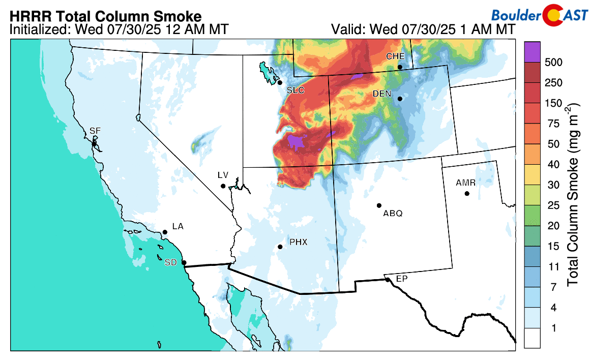
Interestingly, the thick wildfire smoke may actually have some benefits over the next few days by reducing the risk of heavy rain (but also, all rain). It shouldn’t be a surprise that the presence of smoke in the atmosphere can have an impact on weather. In general, wildfire smoke tends to suppress rainfall, and it does so in more than one way.
- The decrease in solar heating caused by smoke can limit instability which can suppress convection and storm intensity.
- A slightly more complex way is through altering the particle size distribution (PSD) of droplets within the clouds themselves. Smoke particles are plentiful and small which makes for small cloud droplets that are less efficient at forming raindrops.
That’s all for now. Keep your eyes on the sky and tuned into weather alerts the next few days. We’re hopeful for widespread rain, just not too much of it at once.

Spread the word — share Colorado weather:
Go Premium, get all the perks.
Daily Forecast Updates
Get our daily forecast discussion every morning delivered to your inbox.
All Our Model Data
Access to all our Colorado-centric high-resolution weather model graphics. Seriously — every one!
Ski & Hiking Forecasts
6-day forecasts for all the Colorado ski resorts, plus more than 120 hiking trails, including every 14er.
Smoke Forecasts
Wildfire smoke concentration predictions up to 72 hours into the future.
Exclusive Content
Weekend outlooks every Thursday, bonus storm updates, historical data and much more!
No Advertisements
Enjoy ad-free viewing on the entire site.


You must be logged in to post a comment.