Strong winds are poised to impact the Front Range over the next four days as a potent Pacific trough moves across the state. The winds will also accompany drastic changes in temperatures from the 70’s to the 30’s, unfortunately. Read on for details.
Chinook winds Wednesday & Thursday
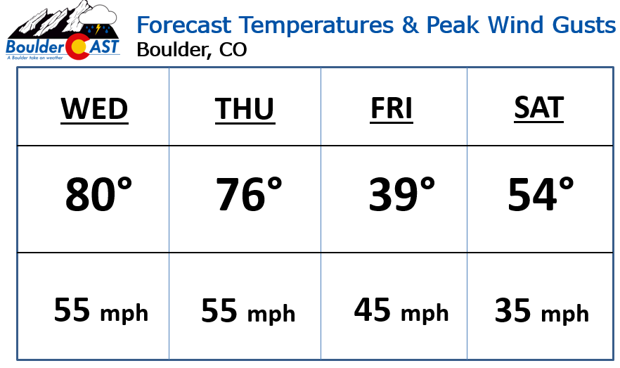
Westerly flow aloft has strengthened significantly with the ridge of high pressure flattening out today. Cross-barrier flow near mountain-top level will exceed 65 mph this afternoon (see wind barbs on the forecast map below). In response to this flow, a lee trough is already developing across the region. The 500 mb map below shows the signature of this lee trough (dips in the height lines) in the middle atmosphere! Winds across the lower elevations will be breezy today, with gusts at times reaching 40 mph. Stronger winds gusting up to 60 mph are expected in and near the Foothills. It’ll be a warm wind, though, with temperatures near 80 degrees and lots of afternoon sunshine!
The record high for April 11th is 81 degrees in Boulder and 80 degrees in Denver. Both will be challenged Wednesday afternoon.
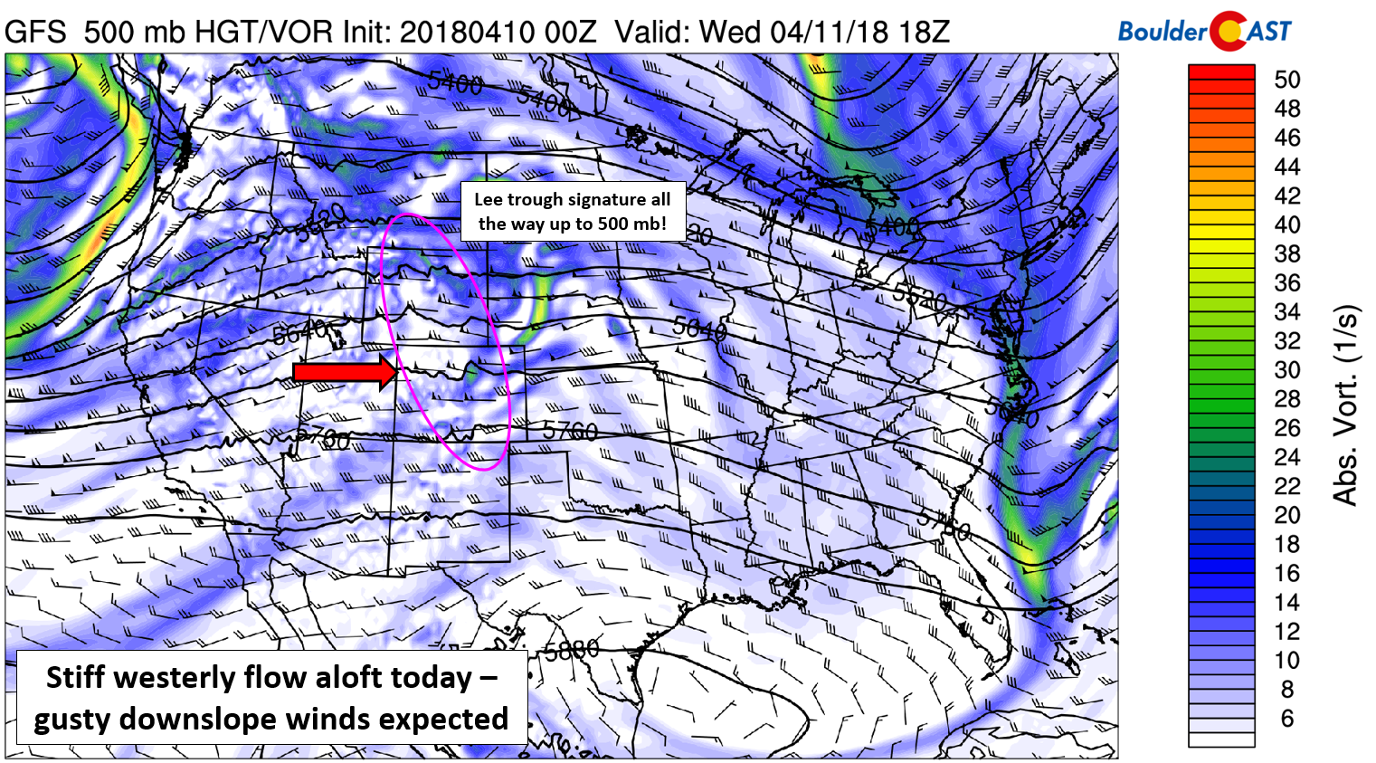
GFS 500 mb vorticity map for today. Notice the strong westerly winds present across Colorado (50 to 70 knots) and lee troughing visible in the height lines.
The cold front we mentioned in our weekly outlook is running just a tad behind schedule. This means we should see another nice and warm day tomorrow as well, with afternoon temperatures in the mid to upper 70’s and slightly more cloud cover. Winds will be strong out of the west again, up to 55 mph across the entire region, particularly Thursday afternoon. RED FLAG WARNINGS are in effect for a huge area (see orange highlights below) for both today and tomorrow. We can’t stress how dangerous wildfire conditions will be. DO NOT USE FIRE! Simple as that.
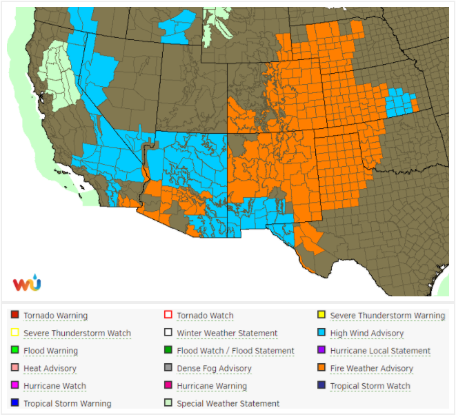
Active weather alerts in place across the southwest United States. Red Flag and High Wind Warnings are everywhere!
Bora winds arrive Friday & Saturday
An upper-level Pacific trough will sweep across Colorado Thursday night and Friday. The 500 mb vorticity map below shows the position of the storm on Friday afternoon.
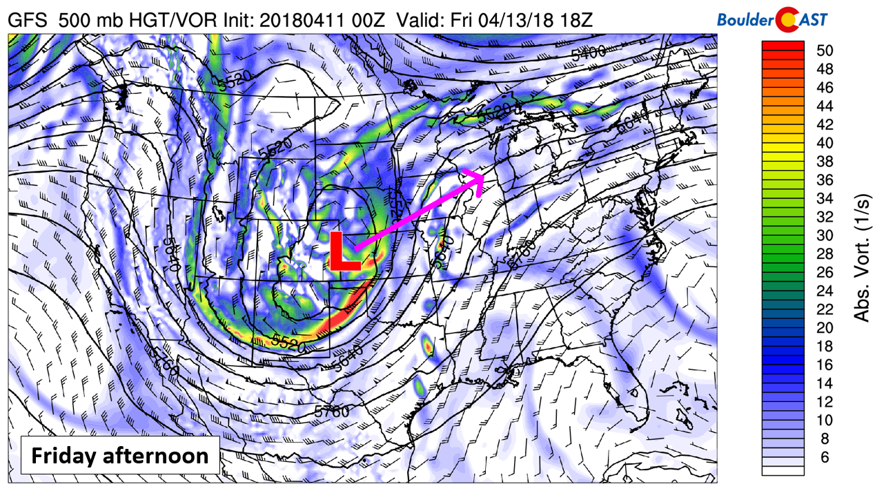
We were closely monitoring this storm system all week with some tempered excitement as it had all the signs of becoming a powerful spring snowstorm for someone, which indeed it will. Unfortunately, the track is not lining up with Colorado. Instead…Wyoming, Nebraska, and South Dakota are on the chopping block for heavy snow this time around…
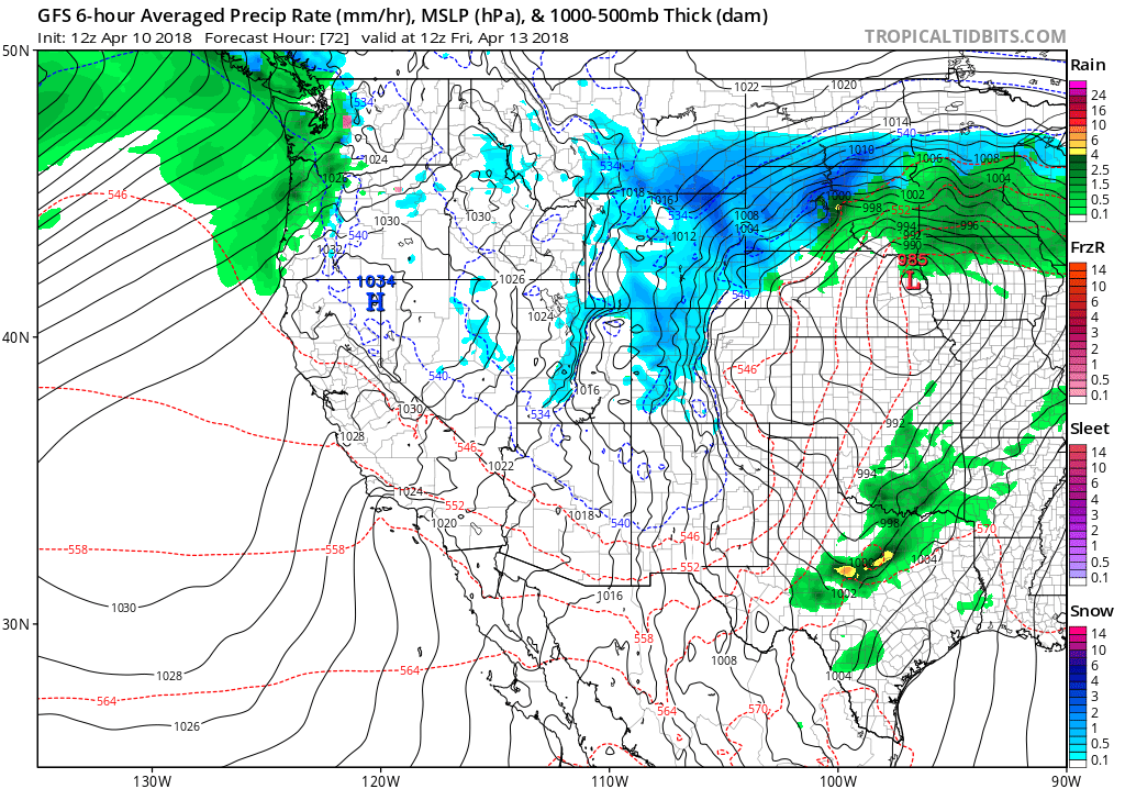
GFS forecast for pressure and precipitation Friday morning. The storm is set to track well north of Denver.
Nonetheless, big changes are brewing late in the week after the cold front passes through northern Colorado. Temperatures on Friday will be 40 degrees cooler than Thursday, with temperatures in the 30’s to lower 40’s much of the day. Winds will remain gusty at least through Saturday, and these won’t be the warm variety…they are the Bora winds, the colder brother of Chinook winds that develop AFTER the storm system has already passed us by! Bundle up if you have plans on Friday!
Right now it appears the primary impact from all this, outside of the wind of course, will be light to moderate Mountain snow accumulations, with downslope keeping things much drier in the immediate Boulder/Denver area. Any precipitation will be a spotty mix of rain and snow and not amount to much of anything. The 800 mb temperature map below for Friday afternoon shows the relatively warm downslope signature across the Front Range. This scenario is so often the case when storms track too far northward.
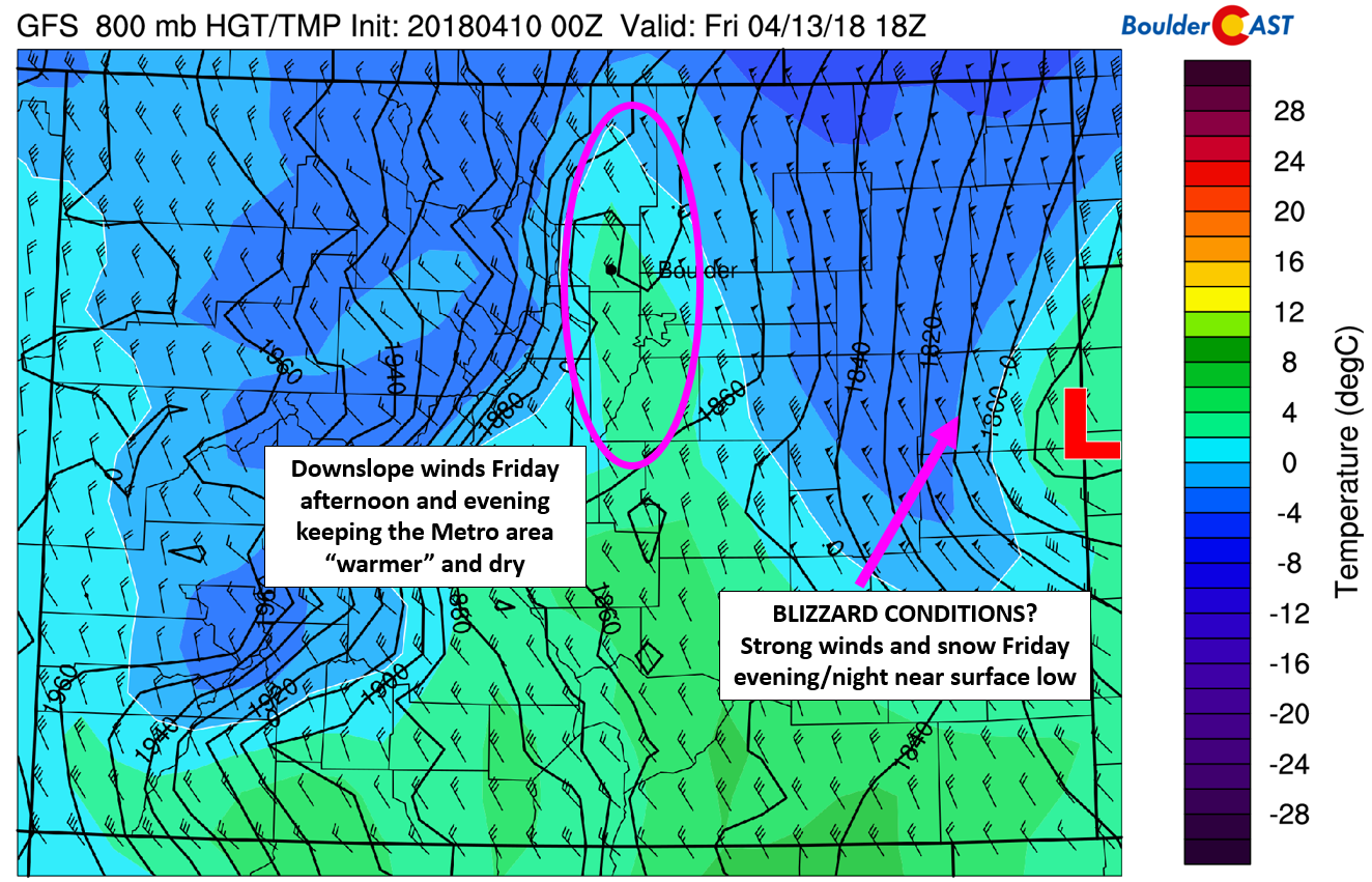
GFS 800 mb temperature and wind map for Friday afternoon/evening.
Models are however showing some light snow accumulations in far eastern Colorado closer to where the surface low is expected to be Friday evening. Combining this with the wind potential, we could be looking at blizzard conditions Friday night in far eastern Colorado along Interstate 70. The GFS snowfall forecast map below shows the “hole” of snow created by strong subsident flow across the Interstate 25 corridor. The ski resorts that remain open can expect 2 to 6″ Thursday night into Friday.
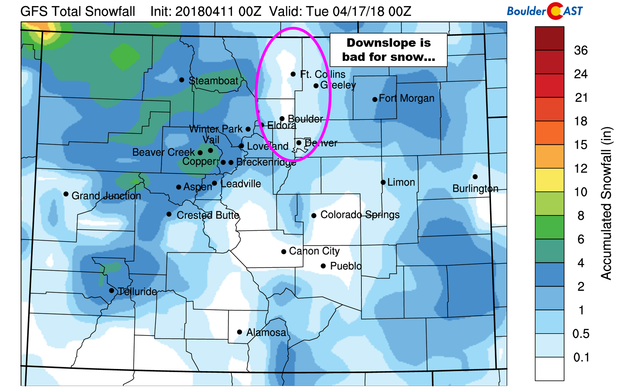
GFS snowfall forecast map for the upcoming storm. The “hole” around the Metro area is clearly visible, a sure sign of downslope.
Saturday will see continued breezy conditions as the storm system exits into the Midwest. We’re probably talking 25 to 30 mph gusts at times, particularly early in the day. Sunshine returns, though, with temperatures warmer in the 50’s.
Looking further ahead to next week, the pattern is expected to remain active for our region. This isn’t all that surprising….we are in the midst of our wet season after all….
Share this forecast update:
.


