Summer is the one time of year when you don’t need us meteorologists. You already know the weather for today (and everyday) will start sunny, warm into the 90’s, then promptly cloud up and produce a brief storm which generates a “just okay” rainbow before another stunning Colorado sunset. If it feels like we’ve been enjoying a much nicer, less rainbow-filled summer than normal, you’re not alone, nor imagining things. It’s been dry. Historically dry.
We discuss the official return of drought to Colorado and provide our thoughts on the outlook heading into September.
One of the most magical times in Colorado is mid-summer. Despite the extreme heat on the Plains, frequent monsoon rains maintain the landscape’s vibrant shade of green. Yes, summer’s true greatness stems from the brief reprieve we all get from those advertised 300 days of sunshine. You know, the ones we won’t admit we get tired of (just a little!). Summer 2016 has not quite fit that mold…
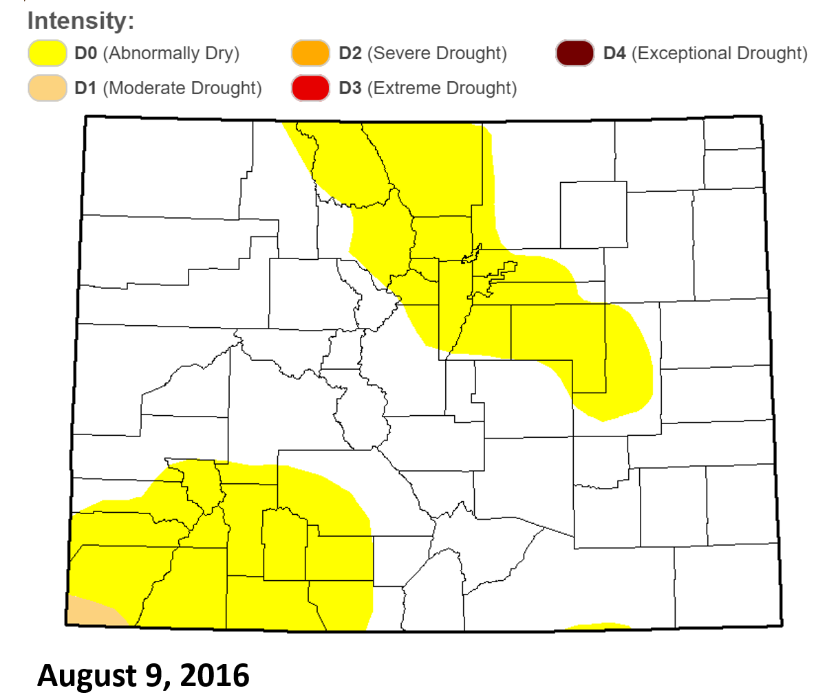
As we foreshadowed in late June, drought has officially returned to the state of Colorado (according to the USDM; see below), though only for a tiny area in the southwest corner of the state. In the Front Range, over the course of the last two months, persistent arid conditions have expanded the “Abnormally Dry” region to encompass all of the Denver Metro Area and the adjacent Foothills.
*NOTE: Rainfall that occurred on August 16, 2016 not included in this discussion or analysis*
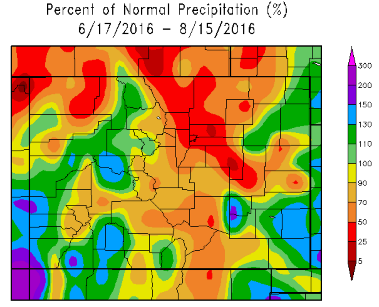
Since June 14th, only 1.36″ of rain has fallen in Boulder, with just 1.14″ in Denver (and even less at BoulderCAST Station – 0.96″). The normal for this time period is north of 3.5″. These dry conditions have been realized almost everywhere in the Metro Area. The map below shows the percent of normal rainfall over the last 60 days for the state.
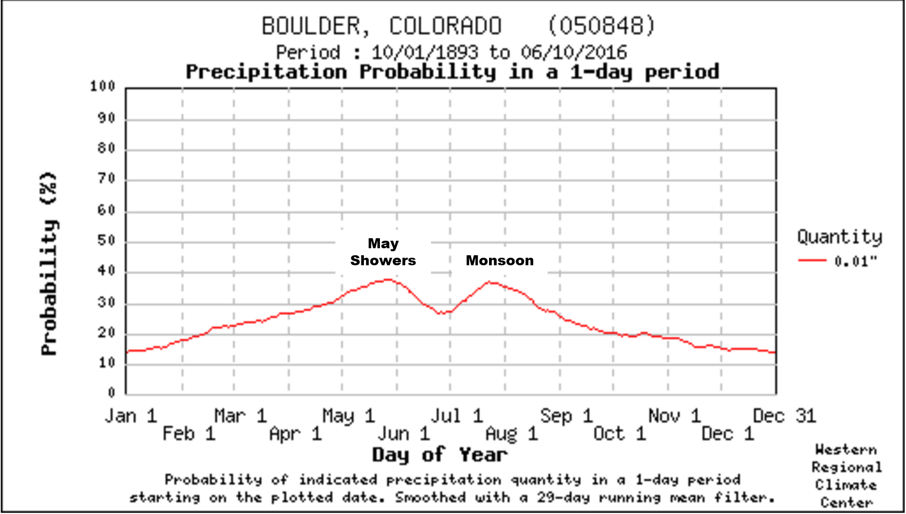
This is very atypical, as the middle of summer is typically filled with frequent monsoon rains. The graph below shows the probability of measurable rainfall occurring in Boulder throughout the year. We see two distinct peaks where the probability of daily rain exceeds 30 percent. The first peak is associated with those pesky May showers. The second, from early July until mid-August, maps to monsoon season.
Unfortunately, the monsoon never truly materialized this summer. In fact, the period of June 14 to August 15 this year was the 9th driest in Boulder’s 119-year record. The graph below shows just how stingy the 2016 monsoon has been with Boulder (this year is highlighted in orange).
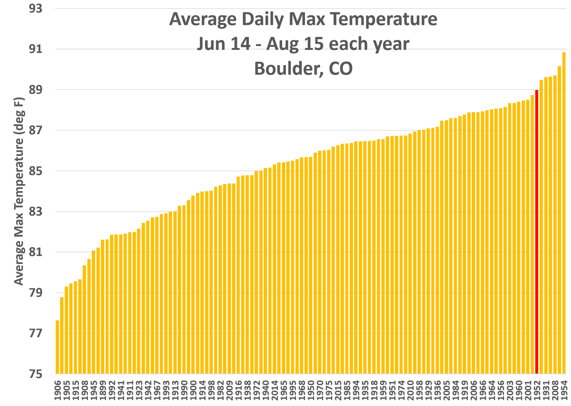
Furthermore, the last sixty days have been the 6th warmest for Boulder on record, depicted below. 2016 is highlighted in red. For note, top dog on the graph is 2012 (A.K.A. “The Year of the Fire”).
Thankfully, as dry and hot as it’s been, “by-the-book” fire weather conditions this summer have been few and far between. We truly dodged a bullet up until this point. We can thank the semi-permanent upper-level ridge that was parked across the region much of the summer (see almost every weekly forecast we posted for the last two months!). The same upper-level warm pool that caused diminished storm coverage also deflected most of the weather systems to our north, which limited the amount of windy afternoons this year.
What does the future hold?
It’s not too late for Colorado to recover from it’s current state. A few good, soaking rains would get us all right back on track. Unfortunately, outside the fall-like dreary weather headed for the Front Range this weekend, there isn’t much indication of things changing as August wraps-up. Based on what 2016 has dished out so far, our top ten historical analogs (years that thus far have been most similar to 2016 in regards to temperature and precipitation for Colorado) paint a bleak picture for September rainfall.
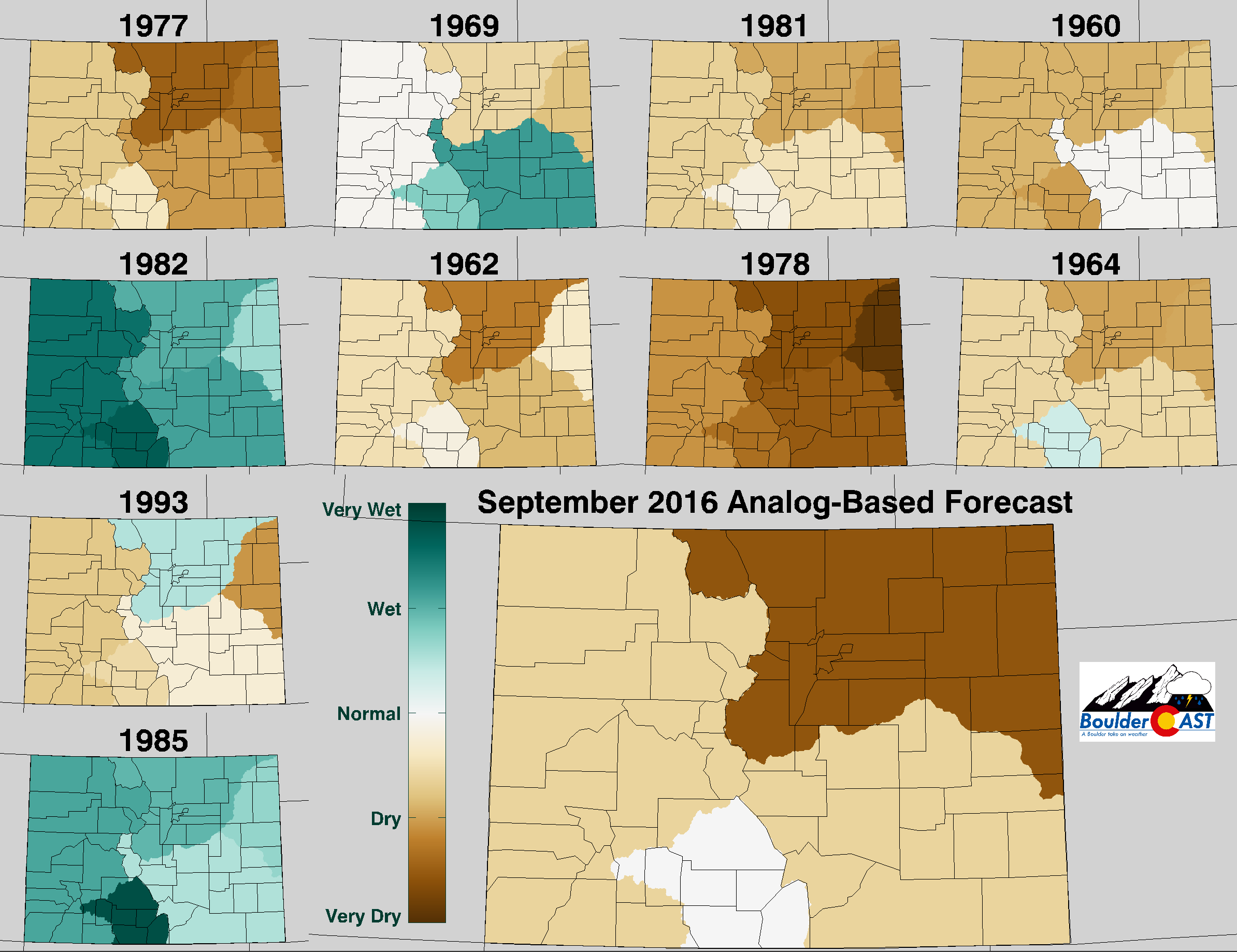
Top ten northern Colorado analog years to 2016 (best analogs towards the top of the image). Shown is how each year’s September played out for precipitation relative to normal. The large tile depicts the weighted forecast based on all ten analog years.
Two years in particular stand out to us, 1978 and 1964. In both, an El Niño during the prior winter weakened to weakly negative ENSO conditions by September, exactly what has happened this year. This combined with long-range model guidance points strongly that this September will end up drier than normal in much of Colorado. Not what anyone wants to hear.
We’ll be sure to keep you updated over the next several weeks if things are changing (and even if they’re not). For now, respect that FIRE BAN and enjoy the fall chill this weekend!




You must be logged in to post a comment.