
We’ve got a quick forecast update for you on this beautiful Friday afternoon. You probably have heard already, but it appears that snow will make a return to the Front Range next week— perhaps even in the form of a monster snowstorm if we play our cards right. Let’s take a look at this admittedly still uncertain forecast and what could potentially transpire next week across the area.
At a Glance
- We’re tracking a major change in our weather next week with some snow likely returning to the Front Range
- Lots of model variability this far out, but early signs indicate a major storm is possible somewhere between northeast Colorado or Montana
- Primary window to watch right now is Tuesday night into Wednesday
- Stay tuned as the forecast evolves in the coming days…
T
he seed for the potential snow will be a strong low pressure system chugging across the Rockies. Since it’s still a solid four or so days away, significant model differences do remain — so keep that in mind. However, large spring storms like this tend to be more predictable in the models than smaller ones….
We’ll start with the good news first (good if you like snow, that is). If you want BIG snow next week, or at least BIG moisture, you absolutely must be cheering for the European model’s forecast right now (shown below). This particular model is advertising a near-perfect setup for a hefty dumping of moisture across the Front Range — a deep Four Corners low that tracks across southern Colorado and blows up into a slow-moving monster somewhere east of Denver on Wednesday.
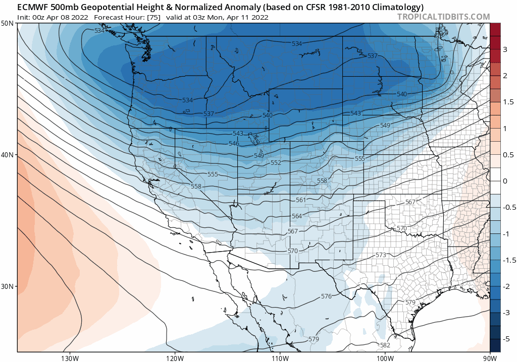
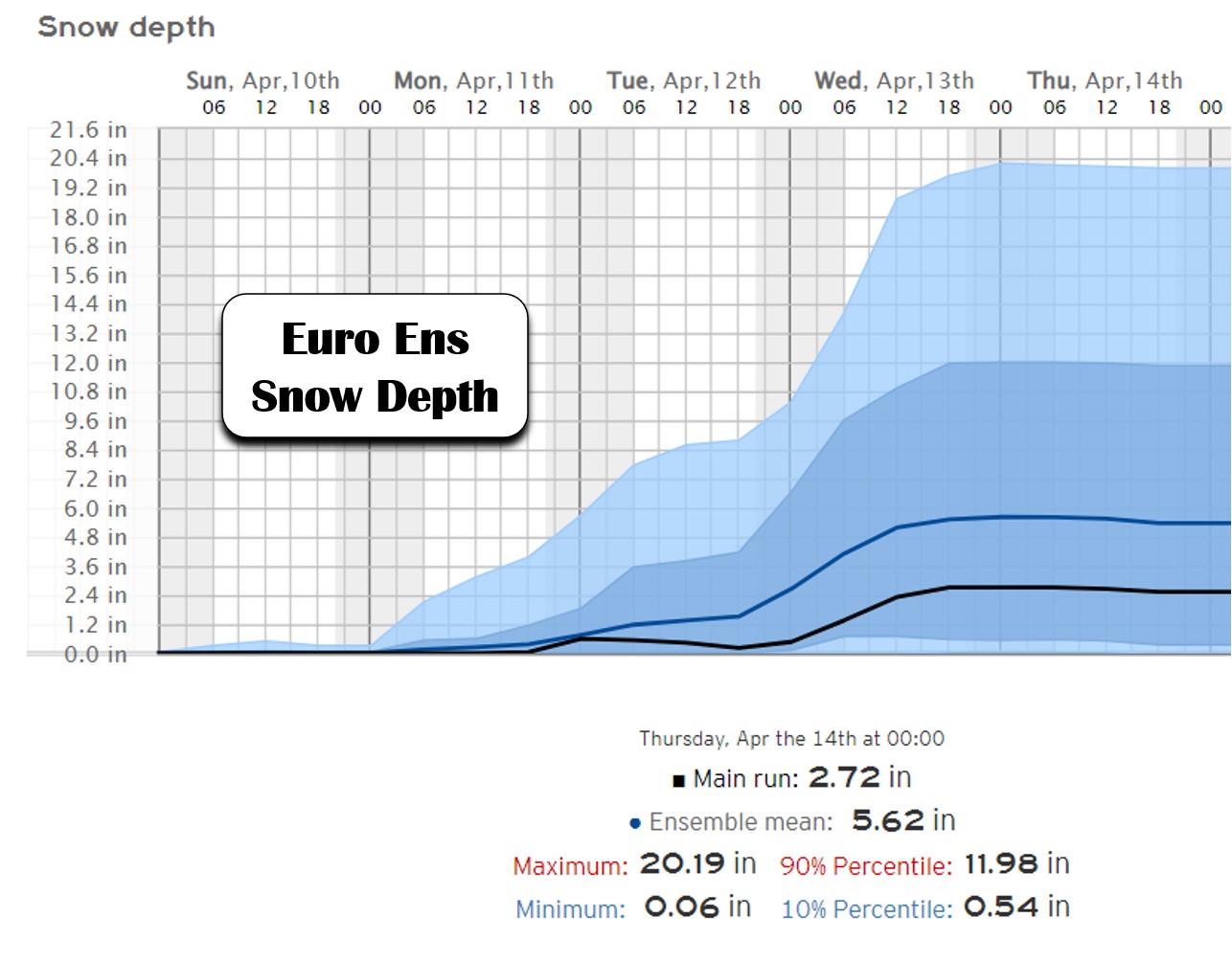
This situation would bring a significant winter storm to our area, including strong winds and blizzard conditions across the plains of Colorado and maybe the Denver area as well. Below is what the Euro model is showing for snowfall — 6 to 12″ in the Boulder-Denver area, with even more further north, further east, and in the Foothills.

On the contrary, the American GFS model is much more disappointing (shown below). The low pressure system it produces never quite digs southward and scoots across the northern Rockies into the Dakotas with little fanfare here.
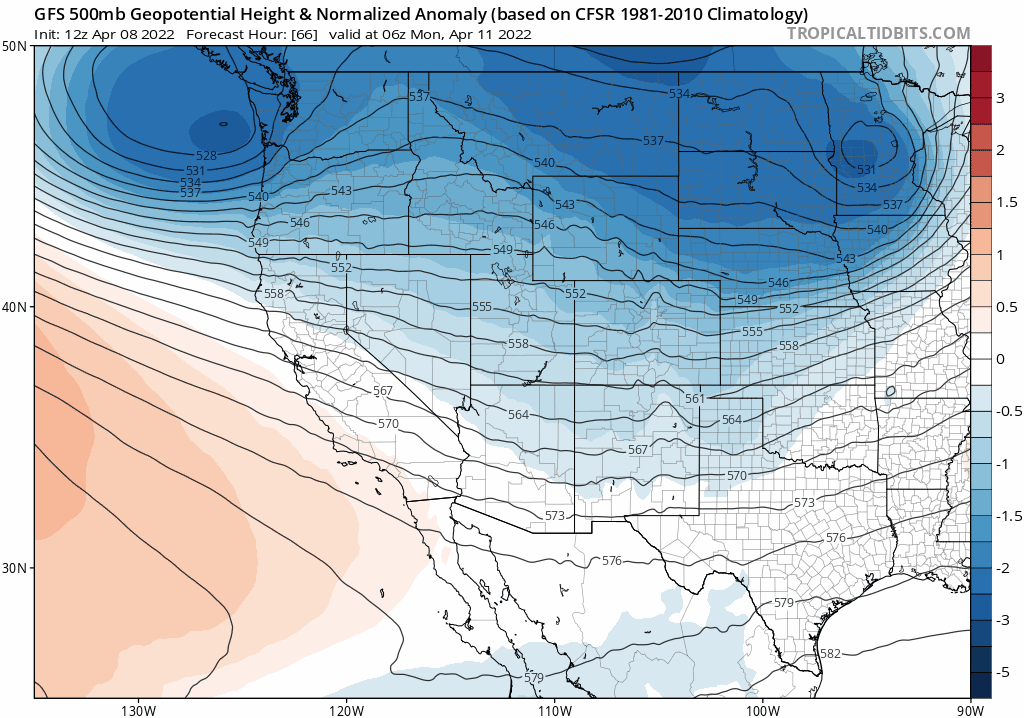
While this pattern would favor a decent dumping of snow in the Mountains, it generally downslopes the Front Range producing little to no winter weather for our area. More importantly, this would starve us of much-needed moisture and could lead to an uptick in fire danger as it passes to our north.
The Canadian model basically splits the difference right now, bringing a storm with middle-of-the-road intensity on a middle-of-the-road trajectory — strong but in a somewhat disorganized manner directly across Colorado.
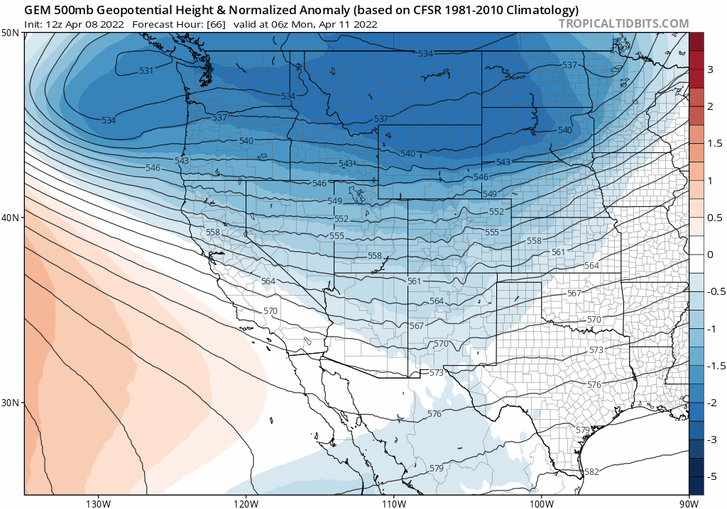
Not surprisingly, this model also produces a middle-of-the-road amount of snowfall — generally just 1 to 3″ across the Denver Metro area.

We must say that the Euro model output is concerningly strong right now, further backed up by its own 50-member ensemble suite which on average is generating around 6″ of snowfall at DIA, with the main event lining up to be Tuesday evening into Wednesday afternoon.
SUMMARY:
There are a lot of details to work out on this storm still — even it’s very existence in the Denver area remains questionable to us. We’re much happier to see this pattern showing signs of being too far north in the models at this juncture. From experience, it’s a lot more common for models to trend southward in time, much more so than pulling a storm back northward. Realistically, there’s not much point in diving into the specifics this early on, especially with this much model variability floating around (i.e. please don’t cancel any plans yet). The Euro model is often recognized as being superior to the American GFS, and while that is true in very basic terms, that’s far from a hard and fast rule. The GFS outperforms the Euro with nearly as much frequency as it doesn’t. We will certainly find out soon which model deserves the praise this time around. Ultimately, though, next week should look a whole lot different than the past one. Enjoy the weekend ahead! There will be more to follow soon…
Get BoulderCAST updates delivered to your inbox:
We discuss Boulder and Denver weather every single day on BoulderCAST Premium. Sign up today to get access to our daily forecast discussions every morning, complete six-day skiing and hiking forecasts powered by machine learning, access to all our Front Range specific weather models, additional storm updates and much more!

Enjoy our content? Give it a share!


You must be logged in to post a comment.