
A shifting weather pattern is on the way as we head into the holiday weekend along the Front Range. Thursday will bring the heat and mostly dry skies, but things could get a bit more unsettled as we head into the Fourth of July and the weekend. If you’ve got outdoor plans in the coming days, here’s what to keep an eye on.
At a Glance:
- Mountain Storms Thursday: A shortwave system is pulling in subtropical moisture, bringing a good chance of storms to the high country, but a strong cap will likely keep most of the plains dry.
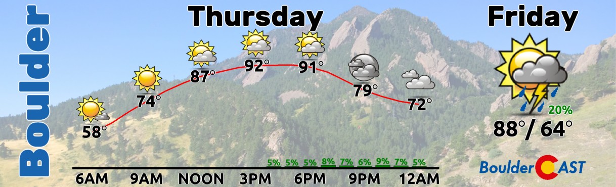
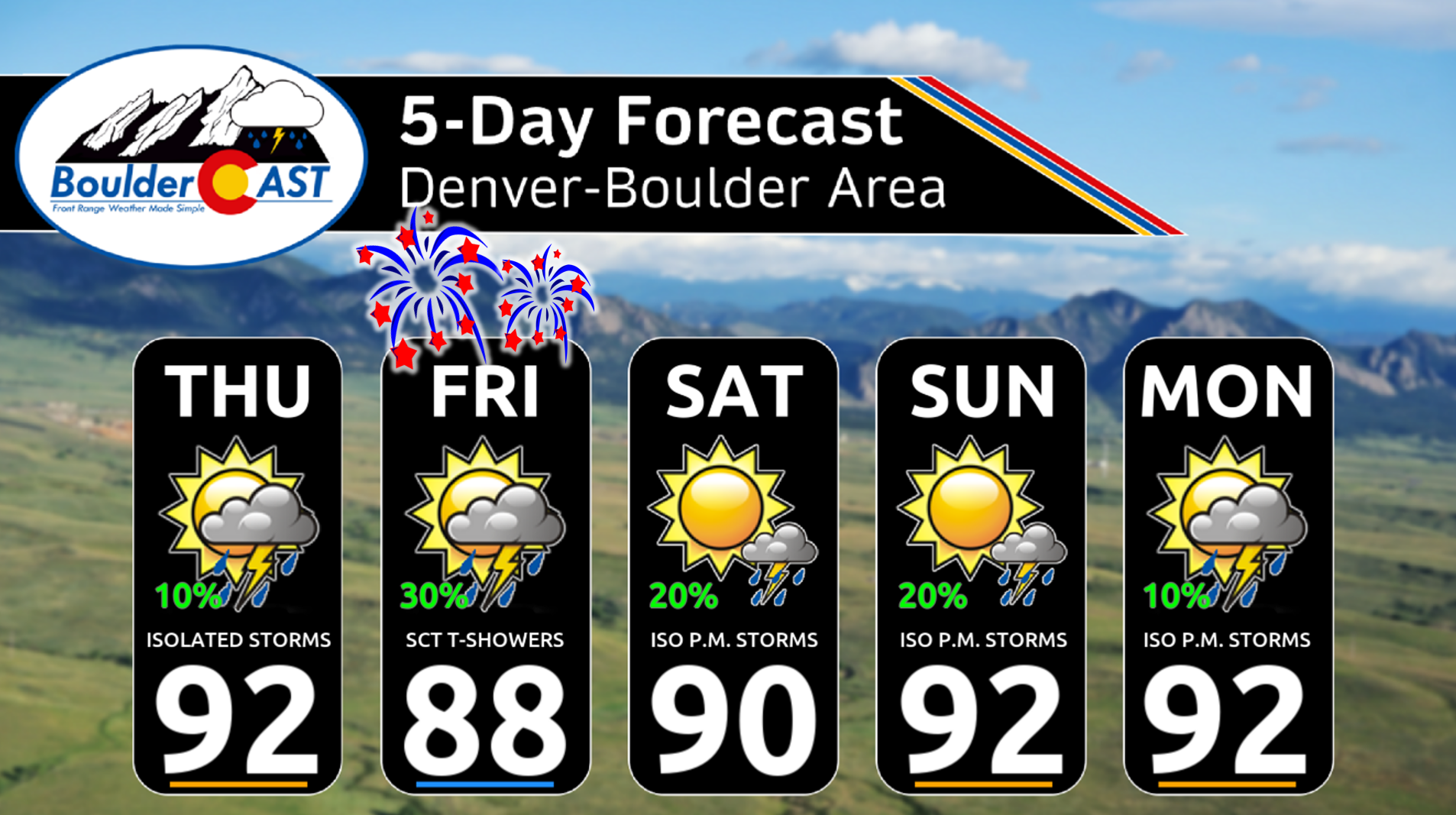
- Hot Thursday: Highs in the lower 90s with only a slight chance (10–20%) of evening storms along the Front Range.
- Fourth of July Rain Potential: Better rain chances arrive for us on Friday, with some models hinting at widespread morning showers. A spotty round of afternoon and evening storms is expected which could disrupt holiday plans. Major disruptions are very unlikely though. Highs will be in the upper 80s.
- Weekend Outlook: Typical early July pattern continues — highs near 90°F, low storm chances in Denver-Boulder, but a better shot for storms and possible severe weather out on the Eastern Plains.

Go Premium, get all the perks.
Daily Forecast Updates
Get our daily forecast discussion every morning delivered to your inbox.
All Our Model Data
Access to all our Colorado-centric high-resolution weather model graphics. Seriously — every one!
Ski & Hiking Forecasts
6-day forecasts for all the Colorado ski resorts, plus more than 120 hiking trails, including every 14er.
Smoke Forecasts
Wildfire smoke concentration predictions up to 72 hours into the future.
Exclusive Content
Weekend outlooks every Thursday, bonus storm updates, historical data and much more!
No Advertisements
Enjoy ad-free viewing on the entire site.
Natural fireworks for the holiday?
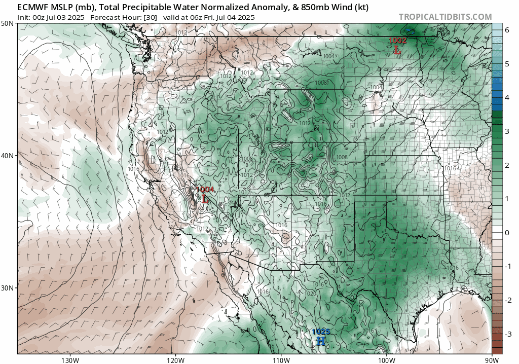
Happy Thursday! We’re starting the day with blue skies across the Front Range, but don’t get too used to it — that’s likely to change later today. A shortwave disturbance currently over southern California is on the move, and it’s set to sweep across Colorado later today into Friday. Together with high pressure to our east, it’s drawing a plume of subtropical moisture northward into the Four Corners region. Already this morning, we’re seeing showers and a few storms popping up over parts of Utah and Arizona.
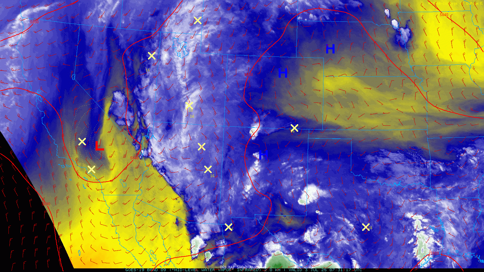
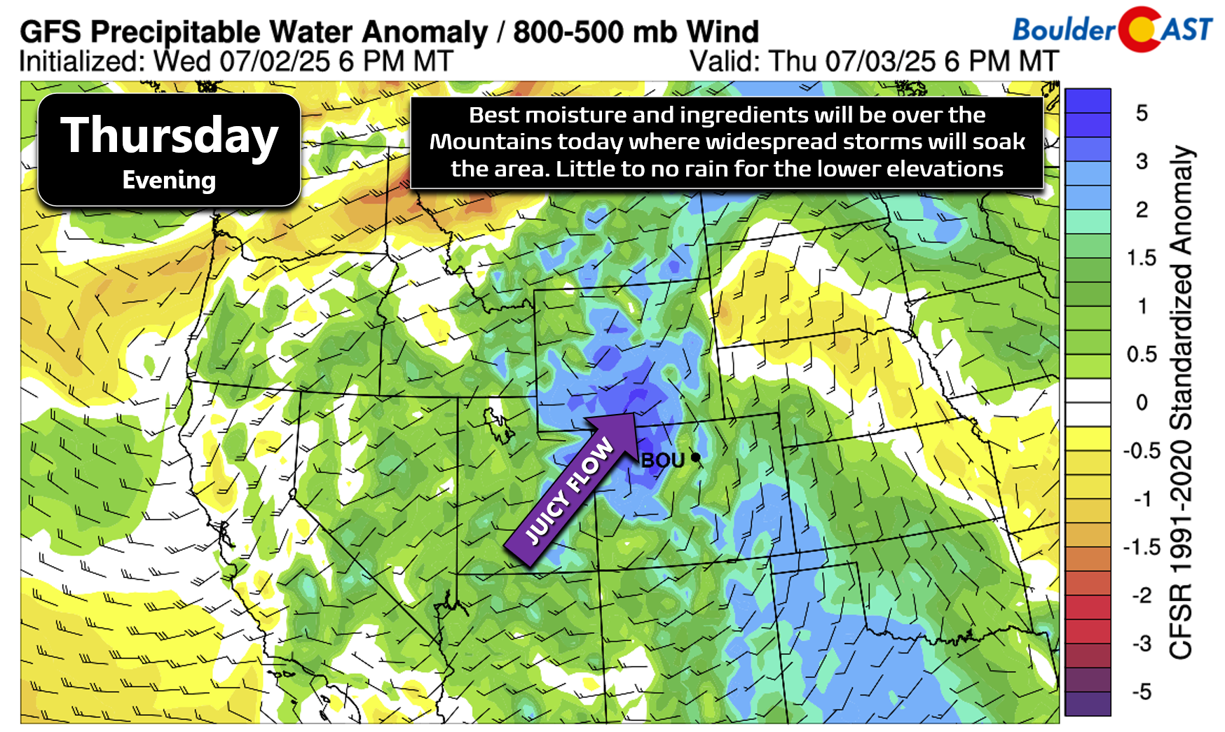
That incoming system is tapping into rich moisture and should bring a robust round of showers and thunderstorms to the Colorado High Country later today. Down at the lower elevations, though, storm chances aren’t looking as good. A stubborn capping inversion will be in place over the plains, limiting storm development. Plus, deep south-southeast flow will keep give us mild downslope off the Palmer Divide, as well preventing storms from drifting off the higher terrain.
Expect another summer scorcher with highs in the low 90s around the Metro area. We’ll start sunny, but clouds will build through the afternoon. Even with that, only about a 10% chance of catching a stray evening storm — most areas will likely stay dry.
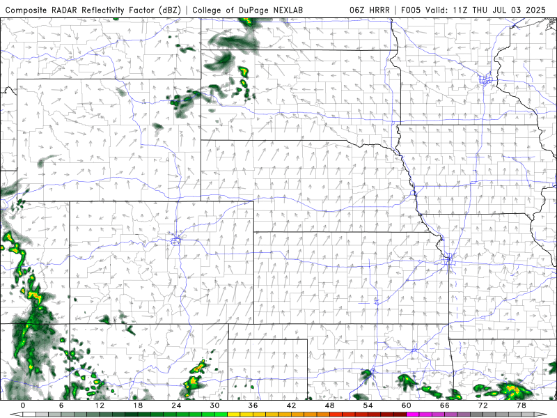
Our best shot at moisture actually comes later — during the overnight into Friday morning. Some guidance is hinting at nocturnal convection kicking up as the disturbance rolls through, aided by cooler air aloft potentially breaking the cap. The HRRR model, for example, is showing a wet start to Friday across northeast Colorado, with scattered showers and storms in play. That said, not all models agree, so we’re cautiously optimistic — just keep rain in mind for the early part of the day.
As the trough pulls away Friday, flow shifts northwesterly, which could help afternoon storms drift off the higher terrain into the Boulder-Denver area. Moisture will still be around, so isolated to widely scattered storms are possible from lunchtime through early evening. They may briefly interrupt holiday plans, but widespread problems look unlikely. Highs will dip slightly into the upper 80s.
While there aren’t any official fire restrictions in the Boulder-Denver area right now, conditions remain dry — Boulder has only received 0.43″ of rain in the last 30 days! Please go easy with backyard fireworks. Even without bans, grasses can ignite quickly as dry as its been of late.
Map of counties with active fire restrictions in place (shaded) as of 7/3/2025
As we move into the weekend, we’ll settle into a classic early July pattern — highs in the low 90s with slim storm chances each day. While the monsoon moisture temporarily dries up across much of the Southwest, eastern Colorado keeps just enough in the tank to maintain a 10–20% risk of late-day storms around the Front Range. The best shot for stronger storms and even some severe weather will be out on the Eastern Plains daily. Conditions across the Mountains may end up being totally dry after Friday as moisture wanes. Thus, if you’ve got camping plans up there, expect excellent weather this weekend.
For now we will include the slight risk of late-day storms in the forecast through the weekend into early next week, with temperatures generally in the lower 90s.
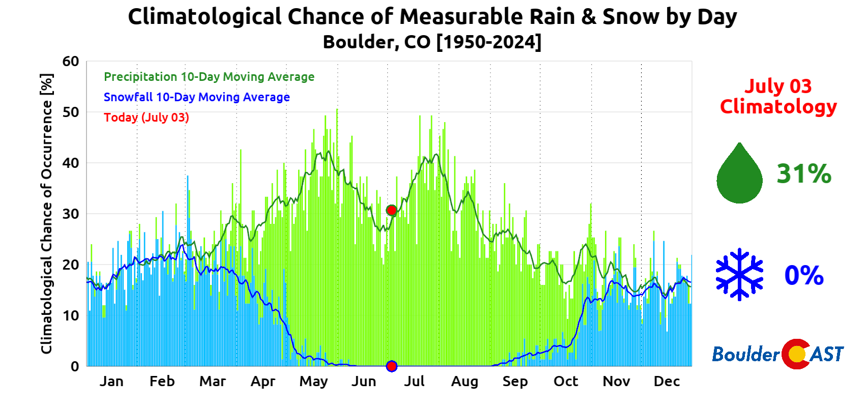
While we did declare the official start of monsoon season earlier this week, just remember that our area is usually right on the edge of the best monsoon moisture throughout the summer. That means we’ll see our fair share of stormy days—but also plenty of dry ones with the monsoon seemingly on a hiatus. Even during the peak of monsoon season in late July, Boulder typically only sees rain about two out of every five days on average. Right now we’re still weeks away from that climatological climax, so there will be even more dry days mixed in.
That’s all for now. Happy Fourth of July from the BoulderCAST team!
![]()
Enjoy our content? Give it a share:


You must be logged in to post a comment.