Gorgeous weather will take hold across the Front Range for the weekend with highs in the 60’s and 70’s. However, another Arctic airmass is gearing up to plunge southward spreading across the eastern two-thirds of the country Sunday into Monday. We take a look at the latest forecast, including when we expect the cold air to arrive in Denver and the outlook for wintry precipitation.
T
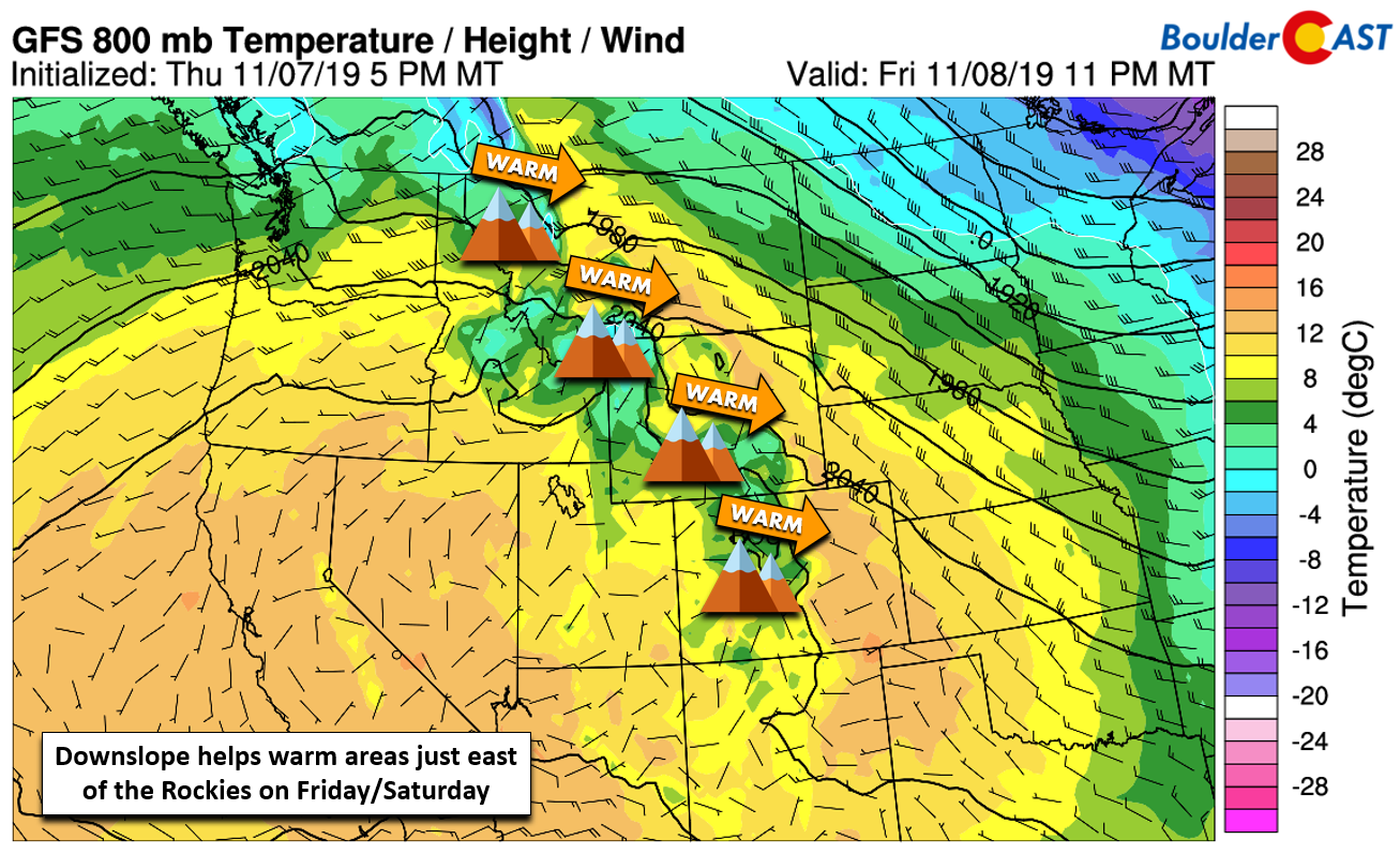
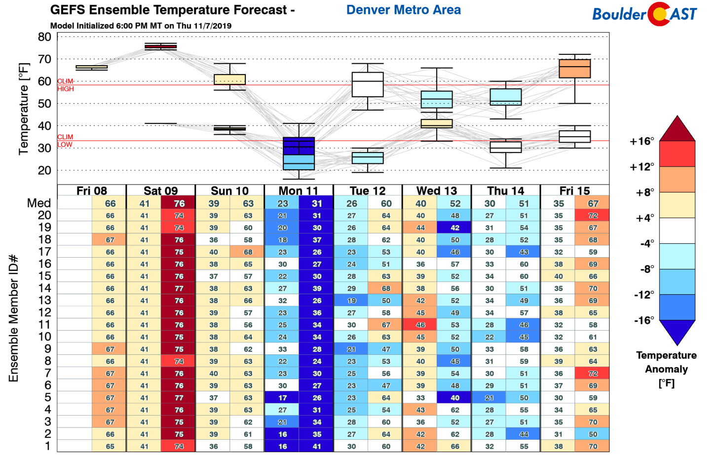
he swings in temperature this week have been dramatic at times. As of Friday afternoon, the storm system that made for an “interesting” mid-week for us has pushed off to the east and is now assaulting the Deep South with record cold and sub-freezing temperatures. A quick shift to high pressure and downslope will facilitate a nice warm-up across eastern Colorado Friday and Saturday with highs bouncing back into the 60’s and 70’s, well above normal for this time of year.
The meandering large-scale weather pattern responsible for the onslaught of winter weather in Colorado over the last two weeks hasn’t bowed-out yet. A highly-amplified ridge remains stretched northward from the western United States into the Arctic Ocean. We reiterate that this is a very favorable pattern for cold air outbreaks in the central and eastern United States.
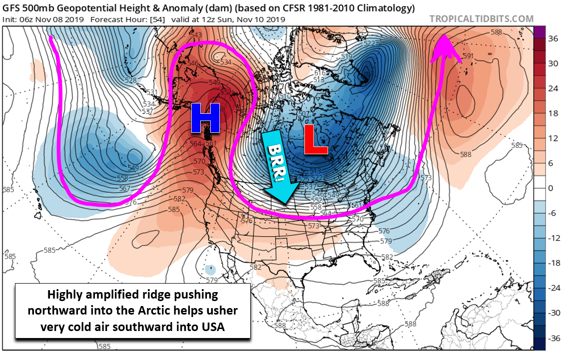
However, compared to the atmospheric set-up that broke a plethora of temperature records in the Denver Metro area last week, the amplified ridge has shifted slightly further east. As a result, the track of the absolute coldest air will likely spare Colorado and move into the Midwest and then the East Coast. Sub-freezing overnight temperatures are expected to make it all the way down to the Gulf Coast and the Panhandle of Florida early next week.
GFS surface temperature anomaly forecast animation covering Saturday through Tuesday. The Arctic air surges southward, clipping Colorado on the way
Despite this, the Front Range won’t escape the Arctic airmass entirely. After a very warm day Saturday in the middle 70’s, a weak cold front will move through Saturday night with cooler weather expected on Sunday (low 60’s). By Sunday evening, the main Arctic front should be surging into northeast Colorado. The timing is not set quite yet, but we expect the front sometime during evening hours on Sunday.
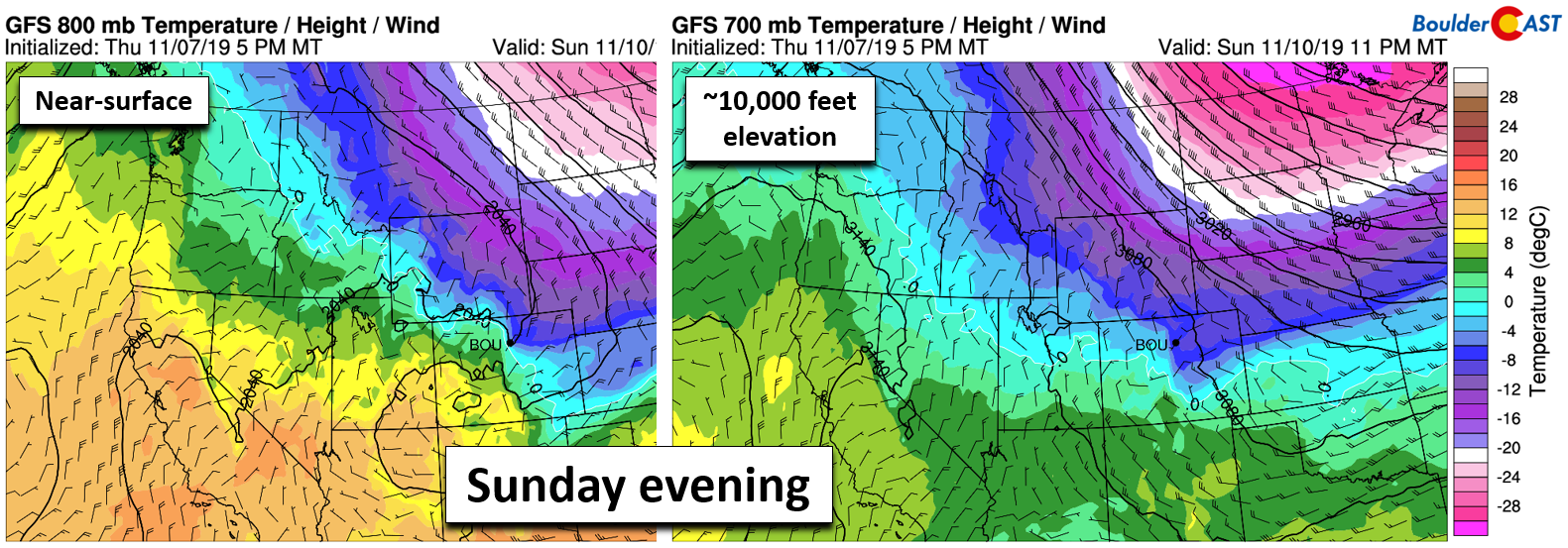
GFS temperature and wind forecast for Sunday evening at 800 mb (left) and 700 mb (right)
It’s a near-certainty that winter precipitation will commence after the front passes Sunday evening. At this point, it appears the dominant precipitation type would be snow as a deep portion of the atmosphere over Boulder/Denver cools and moistens fairly quickly. However, there will probably be a short period of freezing drizzle immediately after the front followed by a transition to snow through the overnight hours.
We’re also watching for a small chance of banded snow behind the front as the jet stream clips northern Colorado. It’s definitely too early to say for sure as models are torn on the placement of the important small-scale jet features that would ultimately form the snow bands. Current trends would suggest that if there is any banded snow, it would be late Sunday night or early Monday morning and that it would be quick and minimal.
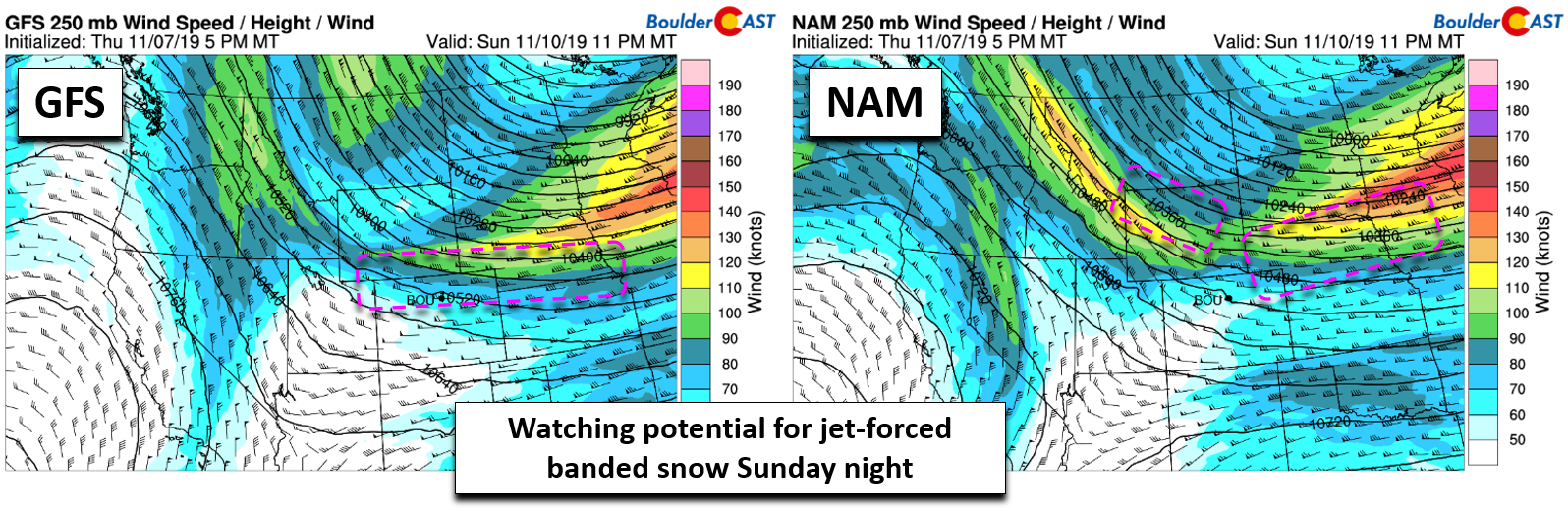
250 mb wind forecast for Sunday night from the GFS (left) and NAM (right). Favorable banded snow locations are boxed in pink
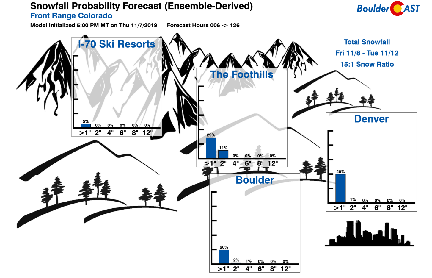
With that said, regardless of how things evolve, this isn’t going to be a big snow-maker for us. The quick-moving nature of the system will limit the duration of favorable conditions for light snow to just 6 – 12 hours at most. Thus, we have HIGH confidence in a very LIGHT snowfall event. Our latest snowfall probabilities show odds are low for anyone to exceed 1″ of accumulation.
We do think that the NAM model has a good grasp on snow amounts for eastern Colorado (below). In general, most of us should see between a dusting and 2″ of snow. In the unlikely event that the heavier snow bands materialize, this could shift into a 1 to 3″ event, which even then is still not a major concern us…
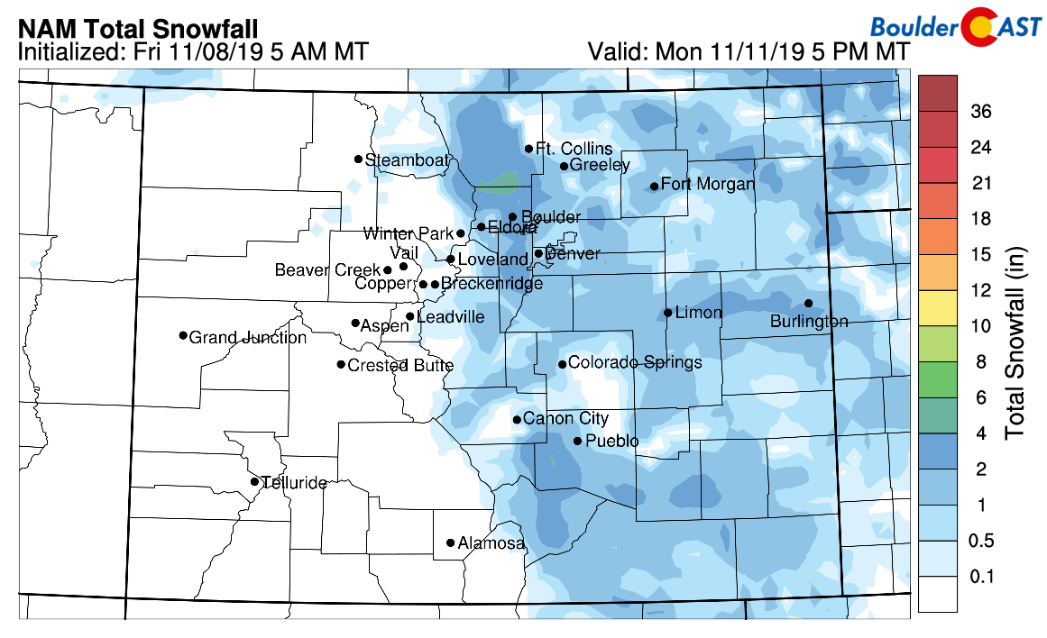
NAM model-derived total snowfall forecast through Monday evening
The bigger story for now remains just how significant cool-down will be on Monday, especially considering the swings on both sides. It’s entirely possible that Monday remains below freezing during the day, but both Sunday and Tuesday could top 60 degrees.
If anything, just be aware that changes are coming Sunday night! If things take a snowier turn, we’ll let you know.
Have a fine weekend!
Subscribe to BoulderCAST for instant email notifications for all of our storm updates, forecasts, and posts:
We respect your privacy. You can unsubscribe at any time.
Forecast Specifics:
Friday: Sunny and quiet with highs in the mid to upper 60’s.
Saturday: An incredible day with full sunshine and highs in the middle 70’s.
Sunday: Cooler but still pleasant for most of the day. Expect morning sunshine, then mostly cloudy skies through the afternoon. The Arctic front arrives in the evening will tumbling temperatures and freezing drizzle changing to light snow. A dusting to 2″ of accumulation is expected on top of a light glaze of ice.
Monday: Gloomy in the morning with lingering light snow showers across the area. Skies should become mostly sunny through the day with highs in the low to middle 30’s.
Tuesday: Partly sunny and dry with highs in the middle 50’s to lower 60’s.
We discuss Boulder and Denver weather every single day on BoulderCAST Premium. Sign up today to get access to our daily forecast discussions every morning, complete six-day skiing and hiking forecasts powered by machine learning, access to all our Front Range specific weather models, additional storm updates and much more!

.
Spread the word, share our forecast:
.


You must be logged in to post a comment.