With Friday being the first day of March, spring is just around the corner! The first several days of the month will NOT look or feel like it, however. Another Arctic front is headed our way bringing potentially the coldest air so far this winter to the Front Range alongside widespread accumulating snowfall. We take a detailed look at the weather set-up this weekend and provide our preliminary snowfall forecast.
Category: Winter Weather (Page 98 of 139)
These posts contain some discussion of the white stuff, whether it be mountain snow pack or a Front Range snowstorm.

Persistent zonal flow this week will keep chances for snow across the Mountains. The lower elevations will generally be dry and quite warm, but a late-week storm system will likely change this.
Heavy snow fell Friday evening across portions of the Metro area. For potentially the first time ever, Denver International Airport reported the highest snow amount region-wide. We discuss the storm specifics and review the snow totals from across the Front Range.
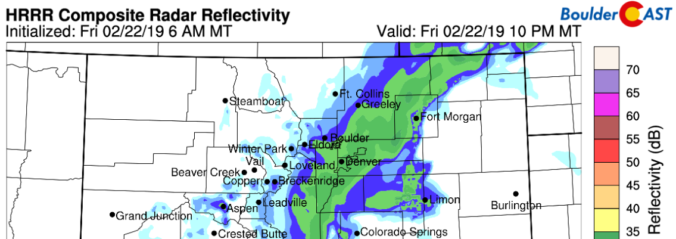
We provide quick a update on the potential for heavy snow Friday evening across portions of the Metro area. Travel may become difficult with 6″ or more of snow expected in some areas.

Unseasonably cold and wintry weather continues across the Front Range through Friday night. Another large storm system will bring the threat of snow and freezing drizzle to the area in two distinct waves. We weigh in on both, including potential snow amounts, and recap the snow event from earlier in the week.

Unseasonably cold conditions and those pesky snowflakes will persist through today and tonight, though amounts will be on the light side. As for the rest of the week, we remain chilly and unsettled, watching as well the threat of a snow event to end our week. Read on for more details.

Winter weather is knocking on the door again in Boulder and Denver beginning Sunday evening. Read our complete forecast covering the timing and amounts for a long-duration snowfall event that won’t fully wrap-up until late Tuesday night.
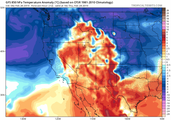
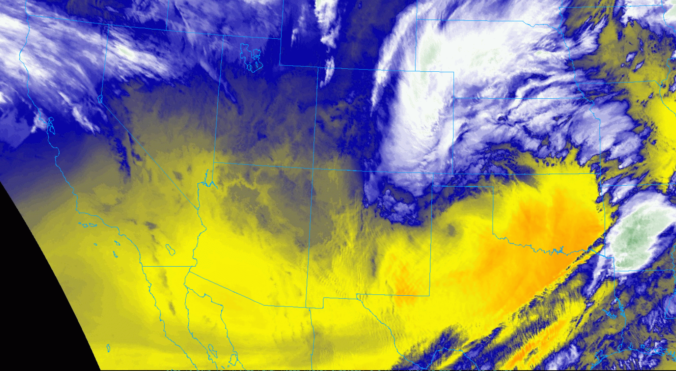
Today’s forecast covers the “cool” front that will move through later today, the heavy snow dumping in the Mountains, and the on-going atmospheric river event in the southwestern United States.

Live View of Boulder

Current Conditions

Live Radar

Recent Premium Posts

BoulderCAST Daily – Fri 06/05/26 | A streak of 90s set in through the weekend
🥵 A streak of 90s today through the weekend with low to middle …
This Weekend in Colorado Weather: Early-Season Heat Ramps Up — First 90s of the Year on the Horizon
🌬️ West–northwest flow Thursday supports high‑based convection with gusts to 35 MPH; virga …
BoulderCAST Daily – Wed 06/03/26 | Scattered P.M. storms again as moisture peaks for the week
🌬️ Weak westerly flow aloft today with no major synoptic features nearby; only …
3-Day Forecast

Trending Content

© 2026 Front Range Weather, LLC