
Unseasonably cold and wintry weather continues across the Front Range through Friday night. Another large storm system will bring the threat of snow and freezing drizzle to the area in two distinct waves. We weigh in on both, including potential snow amounts, and recap the snow event from earlier in the week.
STORM RECAP – Snow earlier this week
C
old weather and intermittent snow have been a mainstay for us this week since Sunday evening’s Arctic cold front blasted through. The break in the clouds yesterday and today have revealed beautiful snow-covered Foothills, which of course is always a good trade-off to dealing with winter weather!
When we issued our last snowfall forecast Sunday afternoon, our team’s confidence was fairly high for the early portion of the event (Sunday evening into Monday morning). However, due to complexities of the pattern itself and the resulting wind fields across the Metro area, confidence was lower for what would transpire Monday evening through Tuesday night. As it turned out, most of the accumulating snow fell Sunday evening (about 3.5″ in Boulder, 1.5″ in downtown Denver). While light snow and flurries persisted through a good chunk of the day on both Monday and Tuesday, little additional accumulation occurred. Generally just a dusting to 0.5″ across the region both days.
Shown below is our snowfall forecast map for the long-duration snow event with totals overlaid in boxes. Green boxes indicate that our forecast verified to within one inch of the observed snowfall. Red did not.

Overall most places landed within the range of our snowfall forecast. Boulder’s official total was 4.8″ of FLUFFY snow from this event. The measured liquid was only 0.18″, equating to a snow-to liquid ratio of 27:1. Other reports from the Metro area show that ratios of 25:1 to 35:1 were common. There’s no snow ratio algorithms out there that would predict these high-end values! This was truly champagne powder! It was a slight bust just east and west of Boulder in areas like Nederland and Broomfield which largely missed out on the snow showers Sunday evening.
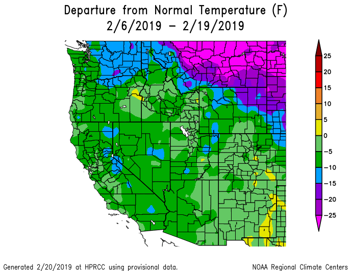
Denver International Airport managed only a trace of snow so far this week. Typical right? Would you believe that Seattle has seen more snow in the last two weeks (20.2″) than Denver has seen all winter long (19.5″)? Making this worse, Seattle’s normal annual snowfall is only 5 inches! Just like Seattle, we’ve had the cold air. Both cities have seen temperatures some 10 degrees below normal over the last two weeks (see below). The problem for us has been storm tracks and moisture availability, or lack thereof. Several strong low pressure systems have dropped south out of Canada and/or Alaska into the Pacific Northwest, but have all weakened considerably as they eventually moved through Colorado.
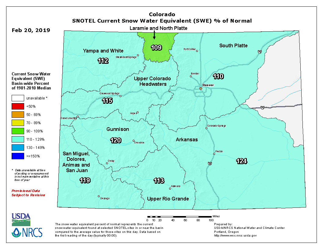
Our one chance at redemption last week, the atmospheric river event, hammered the Mountains but largely left the lower elevations high and dry. At least our snowpack is looking healthy this winter…
We’re not giving up hope yet for the Plains. According to climatology, we still have roughly 40% of our winter snowfall to come, including our snowiest month (March).
FORECAST – More winter weather beginning Thursday evening
Not unlike what transpired earlier this week, another storm system will impact our region in the coming days. The storm’s large breadth and Colorado’s location in the favorable eastern flank of the trough will lead to another lengthy window for winter weather across the Front Range. That “window” is about 36 hours wide, beginning Thursday afternoon and continuing into Saturday morning. The animation below of 500mb height anomaly shows the storm dropping into southern California this morning and then ejecting eastward across northern New Mexico by Saturday morning.
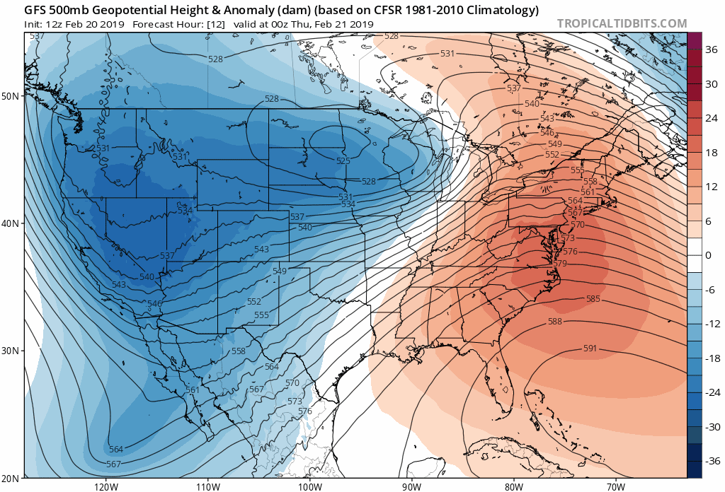
GFS 500mb height animation from Thursday morning through Saturday night
If you notice, the storm stalls for a considerable amount of time in SoCal & Arizona, but ejects rapidly eastward through New Mexico. That initial sluggishness will lead to hefty snow totals in the Mountains near the Four Corners area, including the San Juans which can expect 1 to 3 feet of snow by Saturday. The Grand Canyon is even looking at 8 to 16″!
For our region, the wintry outcome will be much less substantial, but there is still some weather to discuss. The storm system will impact the Front Range in two waves which we cover separately below.
FIRST WAVE: Thursday evening into Friday morning
Several forcings will be aligning beginning Thursday evening that will lead to the chance of winter weather across the Metro area.
Slight lift from trough: The upper-level storm system will still be quite far away near Las Vegas tonight, but weak large-scale lift will be present across most of Colorado during this time.
Weak but moist upslope: A weak cold front will back into the Metro area this afternoon and evening, with easterly flow ensuing across the region. The best upslope will generally be from Boulder north to the Wyoming border
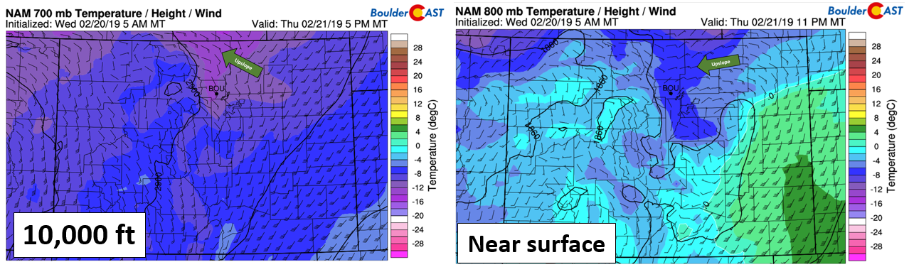
NAM 700 mb (left) and 800 mb (right) temperature and wind forecasts for Thursday night
An overhead jet streak and instability: A weak jet streak will quickly be developing along the southeast base of the trough this evening. The feature is subtle, but northern Colorado will briefly be in the left exit region (and maybe even the right entrance region later on). Furthermore, higher-resolution models are showing instability developing across the Mountains this afternoon with up to 250 J/kg of CAPE. Both the jet and this instability should help produce pockets of heavier snow showers or bands. Our highest confidence in this actually happening is across the Mountains and Foothills, but it isn’t a stretch to believe some of this could spill into the western Metro area, particularly around Boulder and Longmont.
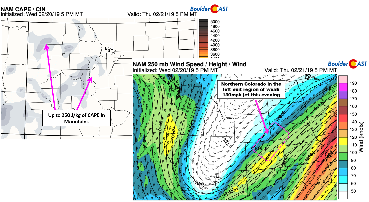
NAM CAPE (top left) and 250 mb wind (bottom right) forecast maps for Thursday evening
The caveat here is that areas that don’t catch the added lift from the jet and instability will likely see freezing fog and drizzle instead. In fact, as the more intense lift vacates the area after midnight Thursday night, most of the Metro area will likely transition into a regime with shallow moist upslope being the only forcing, thus leading to freezing fog and drizzle as the dominant precipitation type below 7500 feet elevation.
Confidence overall is low as to exactly how much icing there will be. In any case, do use caution if traveling late Thursday night or early Friday. Bridges and overpasses will be the first to glaze over and become slick. Take it slow on the Friday AM commute! For locations that do see snow, we’re not expecting much….generally only a trace up to 1″. Localized areas in the Foothills and around Boulder could see a few inches if a heavy band hits.
SECOND WAVE: Friday evening into early Saturday morning
Part two of the event comes Friday evening and night as the upper-level storm tracks across northern New Mexico. This will bring slightly stronger, but brief large-scale lift to the Front Range. Precipitation is expected to be all snow for this secondary wave, with the timing lining up from early evening Friday until after midnight Friday night. We could also once again see some convective snow showers break-out across the higher terrain with favorable lapse rates and some CAPE in place. With steering flow more westerly Friday evening, it seems more likely that these heavy pockets of snow will push eastward onto the Plains.

GFS 500 mb height anomaly forecast for Friday night
We’re seeing fairly decent model agreement right now, with both the GFS and Euro showing a dusting up to 3″ for the Metro area from this second wave. This seems reasonable, with precipitation quickly ending across Boulder and Denver as drier northwest flow floods in early Saturday morning (see below). Given the timing, the Friday PM commute could possiby be impacted by the moderate to heavy snow showers.

GFS moisture anomaly forecast for Saturday morning
All in all, similar to what happened earlier this week, travel impacts will be low to moderate, but will linger for about 36 hours. Our total snowfall forecast map below covers the total snow potential through Saturday morning. We have annotated an area in red where we think those heavy snow bands are most likely and thus could see locally higher snow totals. A light glaze of ice is also possible, especially east of Interstate 25.

In the Mountains, PowderCAST is predicting 4 to 8″ across the I-70 ski resorts Thursday into Friday evening. Further south, totals of 15 to 30″ are in the forecast. Wolf Creek anyone?

Beyond this weekend, we’re seeing good agreement on all accounts that our pattern will turn quieter next week with zonal flow taking hold over the central Rockies. This should translate into more sunshine and temperatures closer to our seasonal normals.
Support BoulderCAST by sharing our forecast:
REMINDER: TODAY is the last day to sign up for charity trivia night taking place this Saturday evening (February 23). All proceeds go to benefit the Harvest of Hope food pantry in Boulder. Join us and more than 120 participants which have already registered. Click here to learn more and sign up!

.


You must be logged in to post a comment.