
Category: Winter Weather (Page 57 of 139)
These posts contain some discussion of the white stuff, whether it be mountain snow pack or a Front Range snowstorm.
A strong cut-off low pressure system will slowly pass by south of Colorado early in the week leading to below normal temperatures, gusty winds and at times light snow for the area. Little to no accumulation is expected across the lower elevations though. Things turn sunny and warmer Wednesday and beyond, with the upcoming weekend looking particularly stunning. Read on for our complete outlook of the week ahead.
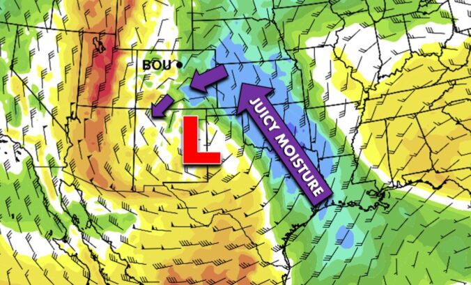
For several days now we have anxiously been looking forward to a big cut-off pressure system forecasted to impact the southern Rockies on Monday. While we’re confident that heavy snow will indeed dump on eastern Colorado, we unfortunately don’t believe that will be across the Front Range. Let’s take a look at the evolving forecast and why this storm will most likely be a swing and a miss for the Denver area.
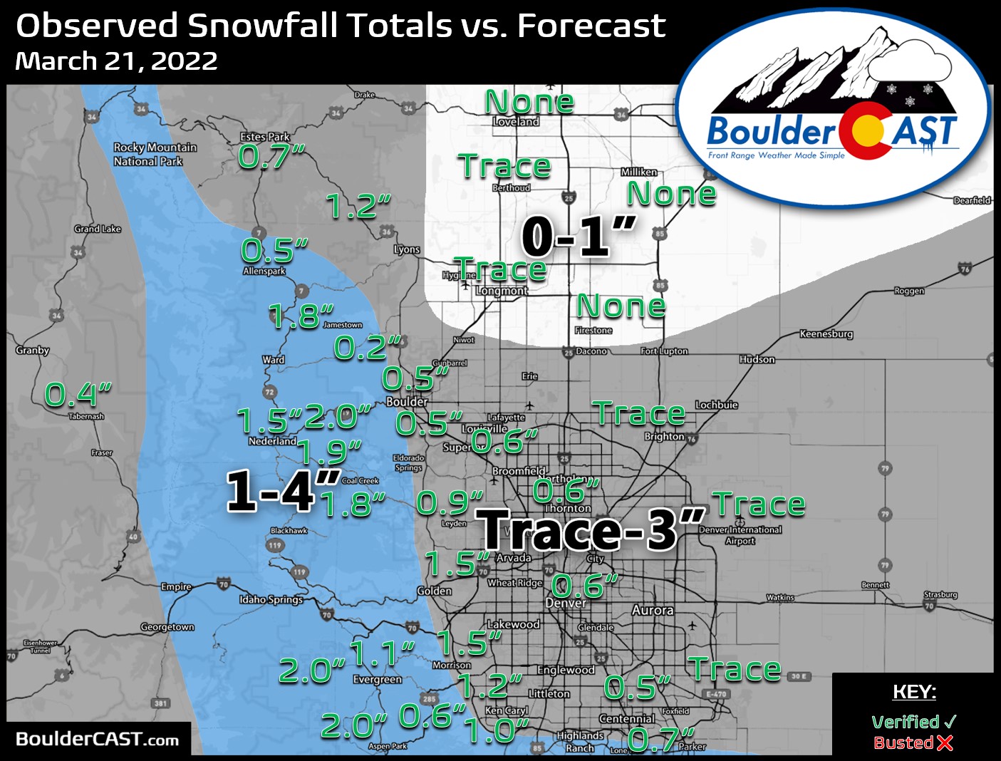
Nothing is ever easy in Front Range weather! The incoming spring, or shall we say winter, storm remains a very challenging forecast as models struggle to resolve where the heaviest precipitation will fall Wednesday into Thursday, the precise timing on when rain will change to snow, and exactly where temperatures will bottom out at overnight. All of these factors are coming together to make for a complicated blend of moderate to heavy rain and soupy snow this evening into Thursday. Most models would have us believe a deluge of precipitation is about to unleash on the Denver area, but there are some red flags. We discuss the latest on this evolving storm which is sure to create quite the mess for everyone over the next 36 hours.

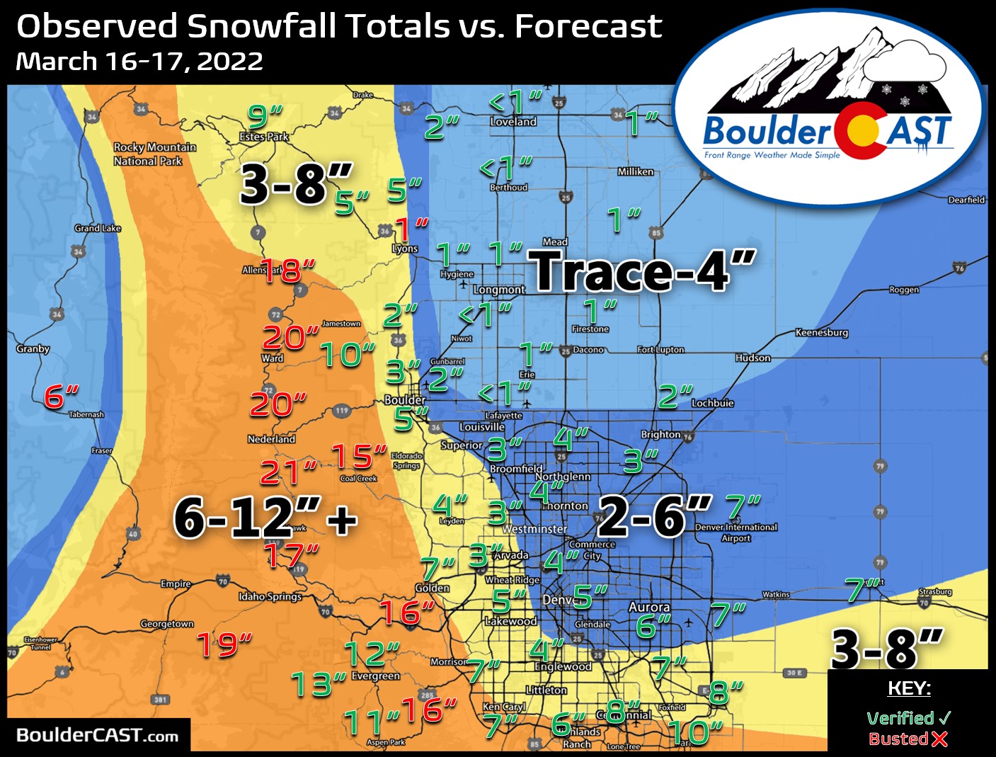
Another Wednesday, another winter storm is going to hit the Front Range! A Pacific trough will impact the area Wednesday into Thursday bringing a return of the white stuff to the Boulder-Denver Metro. Unlike the last handful of snowstorms, this one will have just enough cold air to turn rain over to snow across the entire area. Snowfall amounts remain somewhat uncertain, but most of us should expect at least a couple inches of slushy snow by midday Thursday, with much more in the higher terrain. Let’s take a look at our first “warm” winter storm of the season!
After a mild and gorgeous weekend, the week ahead continues on the same note, at least to start! Colder temperatures and a good threat for rain/snow arrives late Wednesday into Thursday. Uncertainty remains on where snowfall will be greatest, but likely favors the higher elevations of the Front Range due to the marginal temperatures. Sunshine and warmth return for the upcoming weekend.

Live View of Boulder

Current Conditions

Live Radar

Recent Premium Posts

BoulderCAST Daily – Wed 06/03/26 | Scattered P.M. storms again as moisture peaks for the week
🌬️ Weak westerly flow aloft today with no major synoptic features nearby; only …
BoulderCAST Daily – Tue 06/02/26 | Storms Reload This Afternoon, But With Noticeably Less Bite
❄️ Monday delivered lots of hail to northeast Colorado, with one supercell tracking …
BoulderCAST Daily – Sun 05/31/26 | Dry and warm today but rain chances increase this week
🌦️ Overall dry and warm Sunday, though cannot rule out a very widely …
3-Day Forecast

Trending Content

© 2026 Front Range Weather, LLC
You must be logged in to post a comment.