
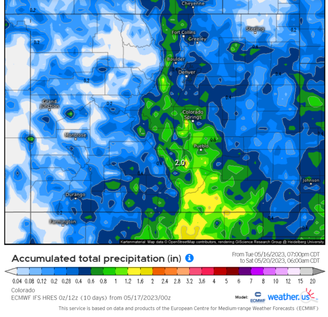
The month of May will end with several days of highs in the 80s. This warmth will be felt largely into midweek as ridging extends into the Front Range area. Although the chance of showers and storms will exist early in the week, the better chances crops up from Wednesday onward as a closed low pressure lifts into the region. This system may linger into the early part of the weekend and there could be some risk of excessive rainfall. Read on for our full outlook of this abbreviated holiday work-week.
Category: Severe Weather (Page 12 of 21)
The posts contain discussion of severe weather in our region, including forecasts, outlooks, and recaps of events involving large hail, damaging winds, and tornadoes.

The story since late last week has been the infiltration of smoke into the Front Range from distant but numerous Canadian wildfires. That trend will unfortunately continue early in the week with light to moderate smoke sticking around through at least Tuesday or Wednesday leading to degraded air quality. Fortunately, the pattern will shift midweek whisking away the smoke and changing the headlines to rain and thunderstorms for a few days. Let’s take a look at what is sure to be another interesting week in Colorado weather!
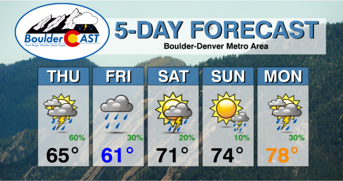
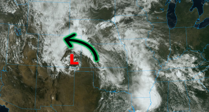
After a cool and wet weekend, this week starts out with a trend toward the drier and warmer side as a departing trough will give way to ridging across the Rockies. While chances of showers and storms will exist each and every day, the best chance won’t arrive until later in the week as a cold front and deep trough dig down from the north on Thursday. This front could also bring the threat of heavy rainfall, flash flooding, and a slight risk of severe weather to eastern Colorado. Temperatures will tumble back below normal to end the week.
This was undoubtedly a wild week in Front Range weather — but one which resulted in multiple good outcomes. The extreme severe weather outbreak planned for midweek got partially busted by low clouds and fog which may have ultimately saved it from becoming the costliest hailstorm in state history. Further, the deluge of rain that dumped to close out the week will go a long way towards eradicating much of the ongoing drought in the eastern half of the state. Let’s take a look back at this crazy week in Colorado weather!

Overnight severe storms produced tennis ball-sized hail in parts of eastern Boulder County, acting as an appetizer for what will unfold later today as the greatest risk of severe weather in years may develop across the Denver Metro area. Low clouds lingering during the morning may delay the severe weather ignition today, but huge hail, damaging winds and a few tornadoes are still in the cards for the afternoon and early evening hours for some area. After the severe weather threat diminishes, soaking rain becomes the story Thursday into early Friday with areal flooding possible.
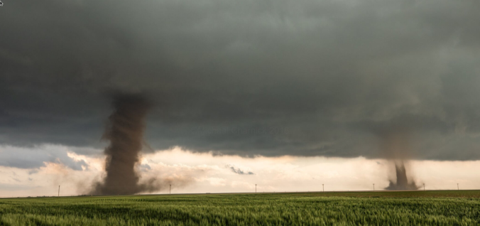
One of the most widespread Front Range severe weather outbreaks in recent memory is taking shape on Wednesday, though we still have some concerns. Two-inch hail, damaging winds and a few tornadoes are likely across eastern Colorado on Wednesday. Before that however, there will be another more uncertain bout of severe weather Tuesday night for the northern Front Range with big hail the main concern. Let’s get into this two-folded complex forecast!

Live View of Boulder

Current Conditions

Live Radar

Recent Premium Posts

BoulderCAST Daily – Sun 05/31/26 | Dry and warm today but rain chances increase this week
🌦️ Overall dry and warm Sunday, though cannot rule out a very widely …
BoulderCAST Daily – Sat 05/30/26 | A stray shower today as most activity resides well east of Denver
🌦️ Spotty showers today, mainly well east of the Denver Metro area, where …
BoulderCAST Daily – Fri 05/29/26 | A Marginal Risk of Severe Isolated Storms
🌦️ Spotty showers this afternoon, mainly noon and 4 PM, with highs in …
3-Day Forecast

Trending Content

© 2026 Front Range Weather, LLC