September is finally upon us — what a great time of the year this is in Colorado! Mother Nature will deliver rather varied weather this week in the Front Range. Hot temperatures and high pressure will give way to a Pacific trough by midweek. Clouds will be on the increase alongside the risk of severe thunderstorms for Wednesday, with even a touch of snow in our highest elevations. Things will clear out nicely for the upcoming weekend leading to gorgeous and seasonal late-summer conditions. Read on for all the details.
Category: Forecast (Page 22 of 161)
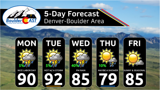
*Premium* BoulderCAST Daily – Mon 09/02/24 | A hot Labor Day near 90° with isolated storms possible producing gusty winds but little to no rainfall
NOTICE: Due to the Labor Day holiday, our usual weekly outlook discussion will be published a day later on Tuesday this week. Please check back tomorrow for the latest on Front Range weather. Early week weather highlights are as follows:
⦁❶⦁ High pressure is centered directly over Colorado Monday but it will slowly weaken as we head into midweek
⦁❷⦁ Expect sunny skies this morning, but increasing clouds during the afternoon and evening — an isolated thunderstorm is possible with little to no rain and gusty winds
⦁❸⦁ More or less the same exact weather for tomorrow but perhaps a degree or two warmer
⦁❹⦁ The week ahead will be largely dry, except for late Wednesday when a weak storm system will clip northern Colorado
Labor Day Weekend won’t be quite as hot as it was on Wednesday, which was Boulder’s 40th 90° day of the year, but we are expecting warm and dry conditions to persist, perfect for any outdoor activities you may have lined up. The weather pattern will shift slightly early next week with the potential for isolated storms returning to the area. Whether you’re planning a trip into the Mountains or are staying comfortably down low in the city this holiday weekend, read on for the latest forecast details!
Recent monsoon rains have brought some improvement in the ongoing drought across our area. However, the weather this week in the Front Range will largely be focused around the passage of a couple dry cold fronts with minimal rainfall expected. Although temperatures will fluctuate from the upper 70s to the lower 90s at times, most of the week will hover near or slightly above normal. As we head into the upcoming holiday weekend, storm chances will increase somewhat as moisture-rich flow tries to re-exert itself over our area. All this and more in our latest weekly outlook!
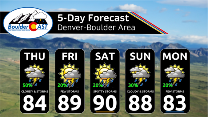
*Premium* This Weekend in Colorado Weather: Monsoon moisture will keep the risk of storms in the forecast as temperatures remain mostly in the 80s

*Premium* BoulderCAST Daily – Wed 08/21/24 | Much cloudier today with late-day storms developing; monsoon moisture will remain over the area through at least Friday
The Southwest Monsoon will remain active across Colorado this week with the best chances for rainfall coming Wednesday through Friday in the Front Range. Storm chances will be greatest across the Mountains with better forcing, upslope, and unstable air leading to a slight risk of flash flooding there. Temperatures during the week in the Denver Metro area will remain near or above normal, but fortunately nothing too hot. Let’s take a look.
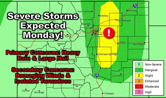
*Premium* BoulderCAST Daily – Mon 08/19/24 | Large hail & heavy rain will accompany monsoon thunderstorms Monday, drier but hot on Tuesday
NOTICE: Due to unexpected travel, our usual weekly outlook discussion will be published a day later on Tuesday this week. Please check back tomorrow for the latest on Front Range weather. Early week weather highlights are as follows:
⦁❶⦁ A narrow plume of monsoon moisture will fuel numerous thunderstorms across the Front Range on Monday during the afternoon and evening
⦁❷⦁ Favorable shear will also be present increasing the risk for severe storms — heavy rainfall and golf ball-sized hail are the primary concerns, but damaging winds and a couple tornadoes also possible
⦁❸⦁ High temperatures reach the upper 80s in the afternoon before the storms cool us off
⦁❹⦁ Tuesday will be the only completely dry day this week as temperatures rebound back well into the 90s
⦁❺⦁ Thunderstorms will be in the forecast Wednesday and beyond with 30-50% chances each day
© 2025 Front Range Weather, LLC

