
A relatively quiet week lies ahead in comparison to the past few weeks. A few cool-snaps will ensue but the general trend will be for warmer weather by the end of the week. This will further help melt any leftover snow. Read on for our complete forecast for the next five days.
Category: Forecast (Page 102 of 169)
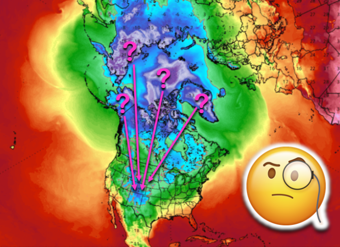
Using a technique called reverse trajectory analysis, we step back in time to see where the bitter cold air this week originated from. We also explain why we believe the odds of another Arctic intrusion into the United States are elevated during the coming week.
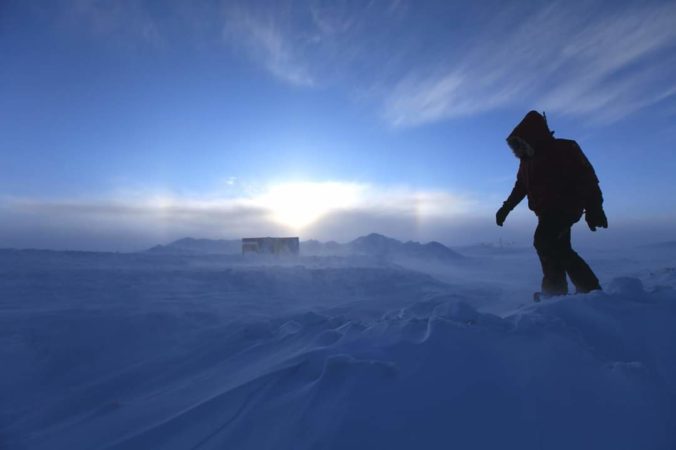
From start to finish, the early season Arctic airmass which overtook eastern Colorado this week has been truly remarkable! The prolonged period of fluffy snow and historically cold temperatures may not be matched the rest of this winter. We take a look back at the wild ride Mother Nature took us on over the last five days and check the snow totals from the second snow event wrapping up Wednesday morning.
There’s no rest for snow-lovers these days! Just as one snowstorm comes to an end, another one is already taking shape to impact the Front Range Tuesday into Wednesday. We take a look at snow totals from the first wave and discuss the evolving forecast for part deux!
UPDATE (7:00 PM Mon 10/28/19): Added our official snowfall forecast map to the end of the post!
PREMIUM UPDATE (7:00 AM Tue 10/29/19): We do a quick check on how the forecast looks this morning as snow begins to fall and bitter cold temperatures push in from the north. Click HERE to read.

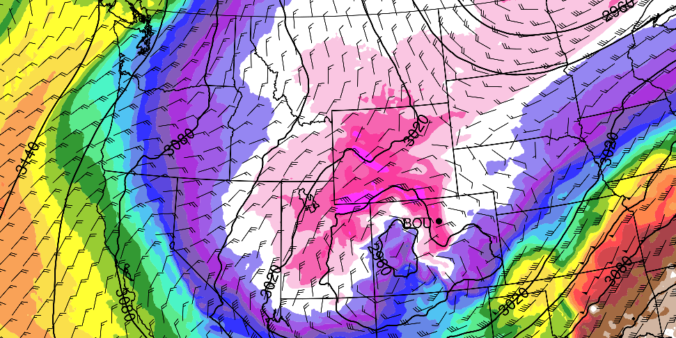
We’re not going to beat around the bush. A complicated forecast is developing for the next several days that will bring two different snowstorms to the Front Range intermingled with potentially the coldest airmass ever to take hold of northern Colorado during the month of October. In this forecast update, we primarily discuss the first part of the storm that will produce snow across the area Sunday morning into Monday morning.
UPDATE (7:00 PM Sat 10/26/19): Added our official snowfall forecast map to the end of the post!
PREMIUM UPDATE (3:00 PM Sun 10/27/19): Read HERE.

As advertised, Wednesday night’s winter storm was a quick-mover! From the first snowflakes to the last ones, only about eight hours elapsed as the tightly-wound storm passed across Colorado. What it lacked for in duration, it made up for in intensity…in some areas. We take a look at the highly-variable snow totals from across the Boulder and Denver area and provide a brief post-mortem on the now-departing storm system. Continue reading

Live View of Boulder

Current Conditions

Live Radar

Latest Smoke Forecast

Recent Premium Posts

This Weekend in Colorado Weather: Several More Scorching Days Ahead Before the Long‑Awaited Monsoon Pattern Arrives
☀️ Persistent heat continues — Low to mid‑90s through Saturday, spiking towards the …
BoulderCAST Daily – Wed 07/15/26 | The Ridge Rules the Rockies as Hot, Dry Pattern Holds Firm
🔥 Heat dome setup continues — A strong, stationary 500 mb ridge keeps …
BoulderCAST Daily – Tue 07/14/26 | The Front Range Continues to Bake Under Expansive Ridge
🔥 Heat streak continues — Boulder hit 97°F for the third time in …
3-Day Forecast

Trending Content

© 2026 Front Range Weather, LLC