Category: Climatology (Page 21 of 63)
These posts contain information about the long-term weather patterns of Boulder County. Potential topics may include 30-day weather outlooks, El Nino/La Nina, and seasonal forecasts. You will find less about the day-to-day weather, with more focus on longer trends and patterns.
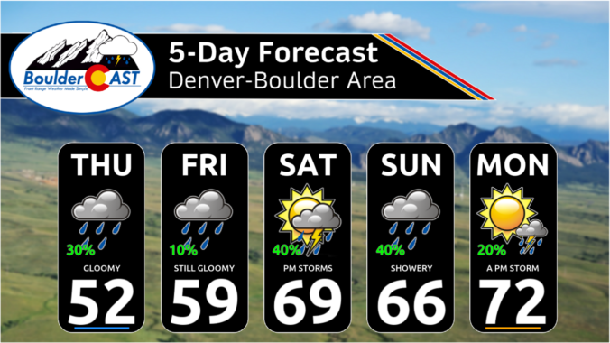
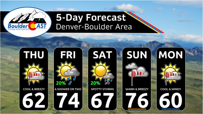
After another round of spring snow over the weekend, the pattern will stay somewhat active across the Front Range this week, but with the warmer late April temperatures translating to only rain chances for the lower elevations. Unfortunately it looks like the gloom will stick around into the upcoming weekend as well. Let’s take a look.
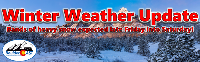
After a month long hiatus, widespread accumulating snowfall will return to the Front Range late Friday as a classic jet-forced banded snowfall event unfolds across the area. While final snowfall totals will undoubtedly vary from location to location, we discuss the latest details of the springtime snowflakes knocking on our door, including when things will commence and expected travel impacts.
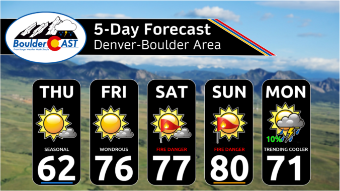
Warm temperatures, low humidity, and strong gusty winds will start our week with continued fire danger across the Plains. A strong area of low pressure will also bring the threat of rain showers late Monday into Tuesday to the Denver Metro area, with heavy snow piling up in the Mountains. Later in the week, a cold front will slide down ushering in below normal temperatures and upslope flow. A prolonged period of unsettled weather will follow this front, with even some late-season snow possible in the Metro area and heavy snow looking likely in the Foothills. Read on to find out more.
The month of March was fairly dry and chilly most of the time, but we can’t forget the historic El Niño snowstorm which slammed the entire Front Range around the middle of the month. Snow totals of 1 to 2 feet occurred in Boulder and Denver with up to 5 feet fell in the nearby Foothills. Here’s a quick and colorful graphical recap of our weather during March and how it relates to climatology.

Live View of Boulder

Current Conditions

Live Radar

Recent Premium Posts

October 2025 Graphical Weather Review: A warm & dry month that prolonged the growing season, delayed our first snow
October 2025 was definitively warm and dry throughout the Front Range with the …
BoulderCAST Daily – Wed 11/05/25 | Relatively cooler today, but far from cool by November standards
🌡️ Cooler but still mild today: A weak cold front has pushed south, …
BoulderCAST Daily – Tue 11/04/25 | Soaring into the 70s today, but a tad cooler tomorrow behind another dry cold front
🌡️ Morning temperature split: Thanks to weak downslope winds, some areas are waking …
3-Day Forecast

LATEST SMOKE FORECAST

Trending Content


© 2025 Front Range Weather, LLC