From record warmth over the weekend, to snow and bitter cold on Veterans Day, to the rebound back into the 60’s just one day later…it’s been quite a wild week in Colorado weather. We explain why Monday’s cold temperatures have joined rare company in Denver’s historical record. The reason may surprise you.
I
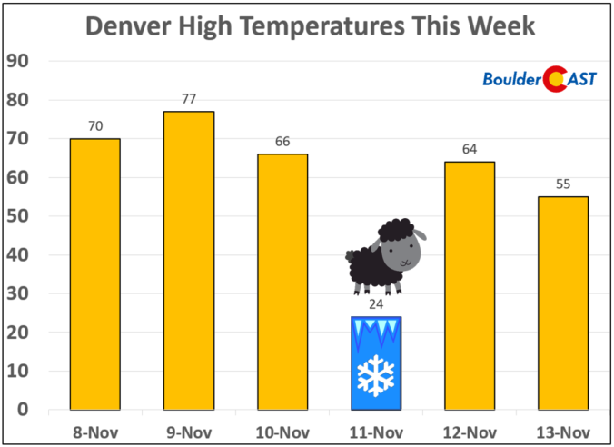
t’s safe to say that Veterans Day this week was a bit of a black sheep. Following record-shattering warmth over the weekend (79°F in Boulder on Saturday!), the swift passage of an Arctic cold front Sunday evening knocked temperatures into the teens by Monday morning. Accompanying the cold, anywhere from 1 to 4″ of fresh snow blanketed the Front Range thanks to an extraordinarily quick-moving system. Our area is no stranger to accumulating snow on Veterans Day; it has happened 4 out of the last 6 years (e.g. 2015 and 2018). By Tuesday afternoon, we were already back into the 60’s. The prior day’s snow and bitter cold were all but a distant memory.

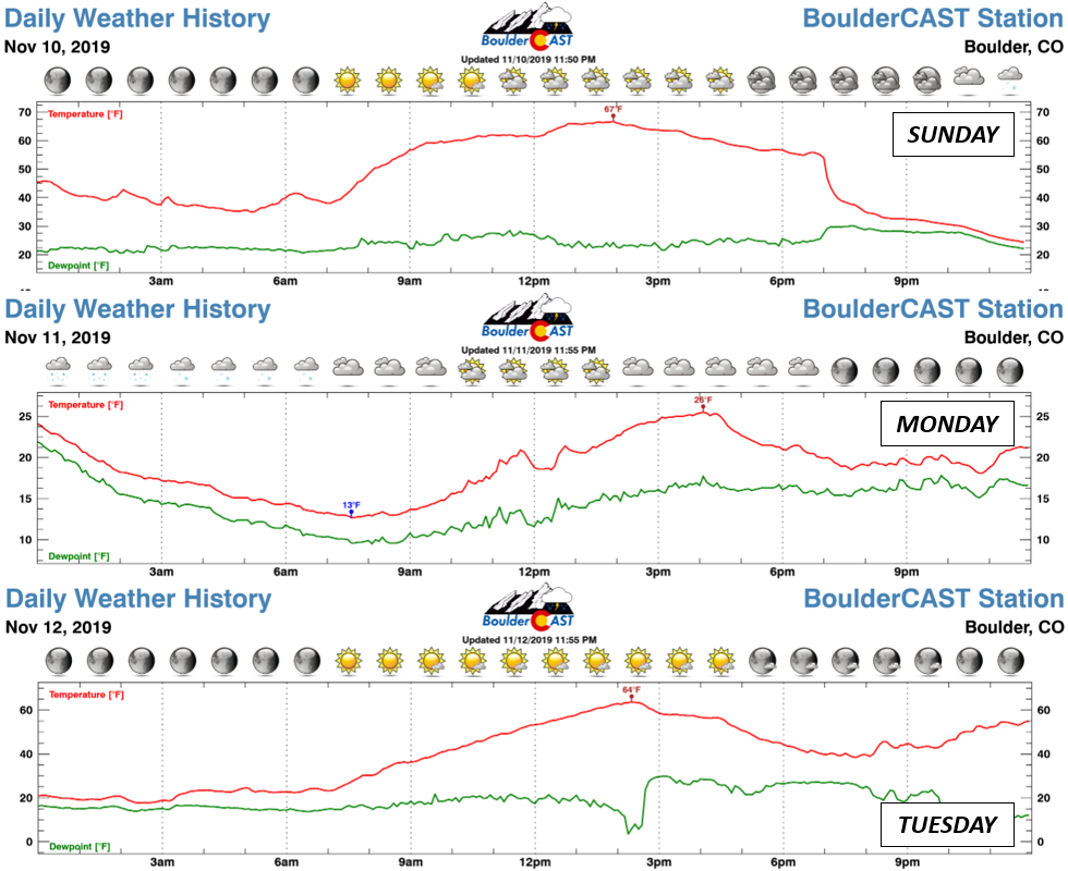
At BoulderCAST Station, the Arctic front arrived around 7PM Sunday dropping temperatures more than 25°F in just one hour (see top graph below). Overall, temperatures made a free-fall totaling 54°F in about 17 hours (67°F → 13°F).
After blasting our area, the potent front eventually pushed all the way into central Mexico. Watch the front surge southward in the animation below. Record cold and sub-freezing temperatures were reported along portions of the Gulf Coast, including New Orleans and the Florida Panhandle. Many locations saw their first snowflakes of the season, even my normally snowy hometown in southwestern Pennsylvania. I even observed a few “bay effect” snow bands developing down-wind of the Chesapeake and Delaware Bays as the Arctic air poured out across their comparatively warmer salt waters.
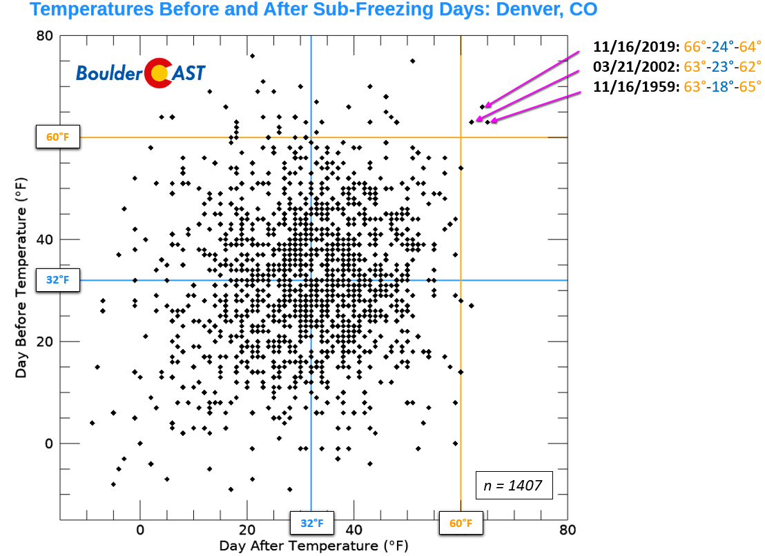
The 36-hour temperature drop at Denver International Airport of 67°F, from 77°F Saturday afternoon to 10°F Monday morning, only ranks 21st in the last 70 years for the largest two-day temperature swing in Denver. It didn’t even beat the 74°F nose-dive we took just one month ago. Despite how extreme this may seem, it wasn’t the magnitude of the temperature drop that made this week’s Arctic airmass truly historic for our area. It was its brevity! Since 1948, there have been a total of 1407 days where the high temperature remained below freezing in Denver. Of those days, only THREE were immediately preceded and followed by 60+ degree days. Monday was one of those three days! The other two were March 21, 2002 and November 16, 1959. The graph below shows observed high temperatures from the day before and after sub-freezing days in Denver.
Just like what transpired this week, those prior two occurrences so many years ago saw very frigid Arctic air slide into the central United States and quickly shift eastward. The panels below show observed 850 mb (near-surface) temperatures the day before the cold in Denver (left panels), the day of the cold (middle panels), and the day after the cold (right panels).
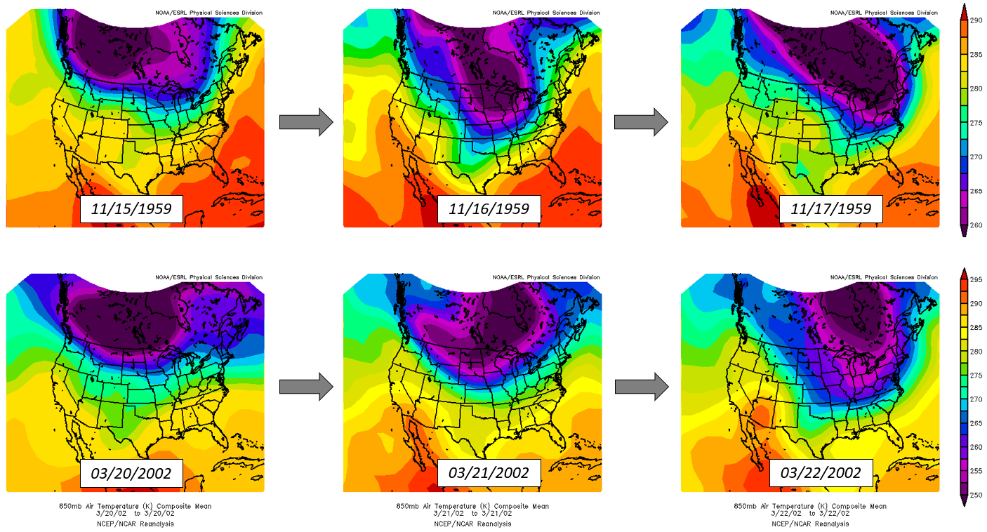
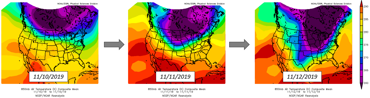
Arctic air is cold, dense, and typically goes where it pleases. There’s no stopping it once it gets moving. However, the abrupt rise of the steep terrain just west of Denver can do just that. When shallow Arctic air surges into eastern Colorado from the northeast, as it does many times each winter, the Foothills and Mountains to our west act like an impenetrable wall, stopping the progression of the cold air in its tracks. For Boulder and Denver, this means that the boundary separating the mild air and Arctic air is never more than handful of miles away, no matter how cold it may feel. This is the precise reason that the Front Range is known for rapidly changing weather and especially quick warm-ups after snowstorms. It’s not just Mother Nature being indecisive…our nearby, wall of mountains make it so we’re always straddling the edge of polar winter. This week’s black sheep is just another example of this, albeit a prime one.

We discuss Boulder and Denver weather every single day on BoulderCAST Premium. Sign up today to get access to our daily forecast discussions every morning, complete six-day skiing and hiking forecasts powered by machine learning, access to all our Front Range specific weather models, additional storm updates and much more!

.
Spread the word, share Colorado weather:


You must be logged in to post a comment.