Author: BoulderCAST Team (Page 17 of 45)
This post had major contributions from at least two members of our team. The more meteorologists the better, right?
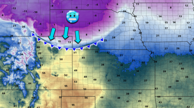
Wednesday sure will be an appropriate first day of winter across the Front Range — the coldest airmass in more than a decade will flood our area! After a warm and windy afternoon of elevated fire danger, the well-advertised Arctic front will blow through by early evening accompanied by tumbling temperatures and pockets of heavy snow. We discuss a few small changes to the forecast including why we are bumping up the expected snowfall totals a tad across the area. Let’s talk bitter cold and white stuff!

Many of you were likely underwhelmed by the snowfall event this week which was inevitable. Despite the media hype for this storm, the most likely scenario, at least from a pattern recognition standpoint, ultimately did unfold across the Denver area with most locations seeing little to no snowfall as the heavier bands stayed just to the east. Let’s take a look at the snow totals across the Front Range!
November 2022 finally broke the streak of four consecutive months of above normal temperatures in Boulder — and by a considerable margin. The bitter cold air led to several fluffy snow events across the area which aided in etching this November as a top ten snowiest and coldest November for the city. Here’s a quick and colorful graphical recap of our weather during November and how it relates to climatology.
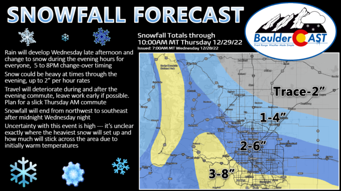
After the surprising minor wallop of snow earlier this week and a brief reprieve on Wednesday, things turn wintry again quickly Thursday into Friday as an Arctic cold front blasts across the Front Range. Shallow but prolonged upslope will produce a period of light, fluffy snow accompanied by bitter cold temperatures. The area in and around Boulder is most favored during this event. In this winter weather update, we discuss the timing of when snow starts and stops, how much snow to expect, which commutes will be impacted most, and just how cold it will get.
Premium Storm Update (11/17/22 7:00AM): Overnight model runs have stuck to their guns and forecast confidence remains high regarding the incoming fluffy snow that will develop this morning and continue roughly 24 hours into early Friday! We provide a brief update on the timing of the snow, check in on the all the overnight model runs, and discuss a few changes we’re making to our snowfall forecast amounts — hint: they are going up a tad! READ HERE
A few last minute changes in some of the short-range models meant the accumulating snowfall last night largely fell unexpectedly across the area. Snow totals were boosted by exceptionally high snow-to-liquid ratios of greater than 25-to-1 in some cases. Let’s take a look at the snow totals across the Front Range!

After a stunning weather-Wednesday, winter conditions are on the horizon again for Thursday as a big storm system moves into Colorado from the west. This one will bring much colder temperatures Thursday and widespread light to moderate snow to the area Thursday evening. Confidence is high that that most everyone will finally get their first accumulating snowfall of the season with this notably colder situation. We discuss the latest timing on the change-over to snow and provide our snowfall forecast map.
Premium Storm Update (11/3/22 7:00AM): Overnight model runs confirm the situation — the accumulating snow for all this evening remains on-track! We provide a brief update on the timing of the snow, how it will impact the evening commute, and discuss a few changes we’re making to our snowfall forecast amounts this morning. READ HERE
Much-needed rain and snow fell across the Front Range on Thursday as a quick-moving storm raced across the state. Though temperatures remained entirely above freezing in Boulder and Denver, some embedded heavier pockets of snow allowed for minor accumulations to occur on the grass in spots, including at the official climate station in Boulder. This made for an interesting but somewhat underwhelming first snowfall of the season for many. We recap the storm, take a look at the snowfall totals across the region, announce the plethora of winners to our 2022 First Snowfall Contest, and look ahead to our next chance of snow.

Live View of Boulder

Current Conditions

Live Radar

Recent Premium Posts

BoulderCAST Daily – Sun 01/11/26 | A mild Sunday with readings reaching the 50s
🌤️ Mild & Melty Sunday: Light winds and patchy clouds, with lingering snowpack …
BoulderCAST Daily – Sat 01/10/26| Widespread sunshine and moderating temperatures this weekend as our recent snow melts off
🌤️ Calm Saturday: Winter storm systems have departed the state, leaving behind a …
BoulderCAST Daily – Fri 01/09/26| Snow ends quickly this morning with a quieter weekend in store
❄️ Overnight snow bands: A second push of upslope after midnight sparked narrow …
3-Day Forecast

Trending Content

© 2026 Front Range Weather, LLC