Author: BoulderCAST Team (Page 15 of 45)
This post had major contributions from at least two members of our team. The more meteorologists the better, right?


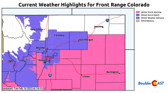
Despite persistent and exceptionally cold weather, March has under-delivered on snow thus far with less than 2″ falling in Boulder since late February. More snow and cold is on the way Sunday night into Monday, but once again it looks to be another meager showing of snow. As of writing, uncertainty remains regarding exactly what will transpire with this event as a band of heavy snow may develop early Monday somewhere across the northern Front Range. Let’s take a look at the timing of everything, the most likely snowfall amounts, and the potential travel impacts as winter weather returns for the last Monday of March.
February 2023 was a chilly exclamation point on what was ultimately Boulder’s 2nd coldest winter in 30 years and the coldest since 2010. This very icy status was solidified by one of the most pronounced late February cold snaps on record. Here’s a quick and colorful graphical recap of our weather during February and how it relates to climatology.
It’s blustery out there this afternoon, but at least there is some sunshine. Our approaching winter storm is gearing up back across Nevada right now and it will be spreading widespread snow into the area tonight. Cold temperatures falling into the teens, gusty winds, and persistent light snow will make for slick travel through Wednesday evening. We run through a final check of the models regarding snow amounts, including a discussion of low and high-end potential for this storm and when it will finally wrap up on Wednesday.
January 2023 was our third consecutive anomalously cold and wet month in the Front Range with drought significantly improving during this time as a result. The month closed out with a bitter cold Arctic outbreak solidifying this January as the coldest since 2007 — something that will be felt in everyone’s wallet when the heating bill arrives. Here’s a quick and colorful graphical recap of our weather during January and how it relates to climatology.

Live View of Boulder

Current Conditions

Live Radar

Recent Premium Posts

BoulderCAST Daily – Sun 01/11/26 | A mild Sunday with readings reaching the 50s
🌤️ Mild & Melty Sunday: Light winds and patchy clouds, with lingering snowpack …
BoulderCAST Daily – Sat 01/10/26| Widespread sunshine and moderating temperatures this weekend as our recent snow melts off
🌤️ Calm Saturday: Winter storm systems have departed the state, leaving behind a …
BoulderCAST Daily – Fri 01/09/26| Snow ends quickly this morning with a quieter weekend in store
❄️ Overnight snow bands: A second push of upslope after midnight sparked narrow …
3-Day Forecast

Trending Content

© 2026 Front Range Weather, LLC