



After a few warm and quiet days, big changes arrive midweek as a southern-track storm system targets the Front Range. Initially we’ll be in the warm and unstable sector with the first severe weather outbreak of 2023 for Colorado taking shape on Wednesday. By late week, the main storm system will slowly move across the state inducing a prolonged period of upslope and soggy conditions across our area. What type of severe weather should we expect on Wednesday and how much rain (and snow) will fall this week? Let’s take a look.
Author: Ben Castellani (Page 96 of 358)
Ben grew up in southwestern Pennsylvania and holds both a bachelor's and a master's degree in Meteorology, the latter being from CU Boulder. His hometown received nearly three feet of snow from the Storm of the Century back in March of 1993, sparking his initial interest in impactful weather. Ben currently works on remote sensing and data analysis software at NV5 Geospatial Software in Boulder.
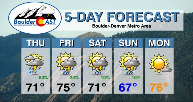


Another wave of precipitation will accompany a cold front racing into the Front Range from the north Thursday night with rain changing to snow across the Denver Metro area. This precipitation will be joined by strong dynamics and northerly flow, making for a gusty and unsettled evening ahead, with some grassy accumulations possible across the lower elevations as snow mixes in late for some. This storm will largely favor areas south of Interstate 70, with the northern Front Range including Boulder not expected to see much. Let’s take a look.


A powerful low pressure system remains on-track to impact the Front Range Tuesday afternoon into Wednesday with several hours of nearly perfect upslope in the works. While there has been a slight southward shift in the storm’s track, we still anticipate widespread soaking rain across the lower elevations and heavy wet snow in the Foothills, including some thunder thrown into the mix. Travel will become extremely difficult Tuesday evening west of town with snowfall rates of 1 to 3″ per hour. Finally, while this event will be almost exclusively just cold rain across the Plains, we may see a little wet snow in the far western and southern Metro area. Read on for all the details.
Live Radar

Trending Content


Recent Premium Posts

BoulderCAST Daily – Wed 11/11/26 | Mild Days Ahead, But There Are Signs of a More Active November Soon
☀️ Warm & Quiet — Sunshine dominates through Thursday with highs rising from …
BoulderCAST Daily – Tue 11/10/26 | Clouds Increase Today, But Colorado’s Dry Pattern Rolls On
🌤️ A Few More Clouds Today – Mountain wave clouds are developing along …
BoulderCAST Daily – Sun 11/08/26 | Mild November Weather Continues, Even With A Cold Front Midweek
☀️ Sunny and warm for early November – Temperatures in the middle to …
© 2026 Front Range Weather, LLC