


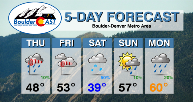
The last week of April will undoubtedly be an interesting one weatherwise across the Front Range as a potent spring storm bears down on Colorado in the coming days. While we still have some concerns about the storm’s track and exactly how low snow levels will come, this will be a classic upslope event with impacts ranging from thunderstorms to soaking rain to heavy wet snow for our area. Furthermore, there will also be another smaller but colder storm late in the week with accumulating snow chances. The Front Range forecast this week sure is busy! Let’s get into it.
Author: Ben Castellani (Page 97 of 358)
Ben grew up in southwestern Pennsylvania and holds both a bachelor's and a master's degree in Meteorology, the latter being from CU Boulder. His hometown received nearly three feet of snow from the Storm of the Century back in March of 1993, sparking his initial interest in impactful weather. Ben currently works on remote sensing and data analysis software at NV5 Geospatial Software in Boulder.


As our snow season begins to wind down across the Front Range, our Winter Storm Updates are arriving to your inbox less and less. However, an interesting setup knocking on the door will create a quick chance of banded snowfall Friday night with everyone poised to see some white stuff accumulate. Let’s discuss the latest on the approaching snow bands including their timing, travel impacts and ultimately how much snow will stick.

Live Radar

Trending Content


Recent Premium Posts

BoulderCAST Daily – Wed 11/11/26 | Mild Days Ahead, But There Are Signs of a More Active November Soon
☀️ Warm & Quiet — Sunshine dominates through Thursday with highs rising from …
BoulderCAST Daily – Tue 11/10/26 | Clouds Increase Today, But Colorado’s Dry Pattern Rolls On
🌤️ A Few More Clouds Today – Mountain wave clouds are developing along …
BoulderCAST Daily – Sun 11/08/26 | Mild November Weather Continues, Even With A Cold Front Midweek
☀️ Sunny and warm for early November – Temperatures in the middle to …
© 2026 Front Range Weather, LLC