Author: Ben Castellani (Page 4 of 306)
Ben grew up in southwestern Pennsylvania and holds both a bachelor's and a master's degree in Meteorology, the latter being from CU Boulder. His hometown received nearly three feet of snow from the Storm of the Century back in March of 1993, sparking his initial interest in impactful weather. Ben currently works on remote sensing and data analysis software at NV5 Geospatial Software in Boulder.
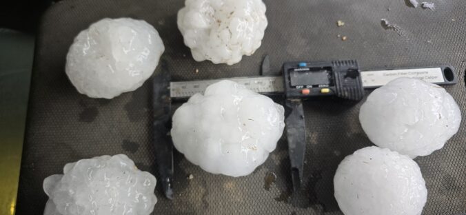

Warmth, wind, and a few atmospheric curveballs are lining up for the Front Range this week — and it all starts with a sharp swing from severe storms to hot fire danger in less than 24 hours. From Monday’s hail‑ready instability to mid‑week blow‑dryer conditions and a potential cool‑down lurking on the weekend horizon, this week’s forecast has a little bit of everything. Read on as we detail what to watch as this surprisingly active June pattern unfolds across Colorado.
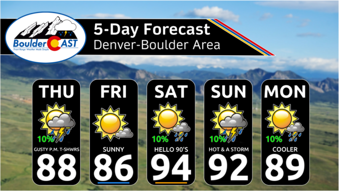

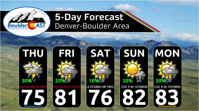
Spring’s grip on our wet season is loosening, and the atmosphere is starting to hint at the drier pattern ahead — but not before we squeeze out a few more days of spotty storm potential. This week brings a mix of low‑end daily rain chances, early‑week severe storms, and a slow warm‑up that could push us toward our first 90° reading of the year by the weekend. Read on as we break down what to expect as we ride out this transitional stretch of early June.

Live View of Boulder

Current Conditions

Live Radar

Latest Smoke Forecast

Recent Premium Posts

BoulderCAST Daily – Wed 07/29/26 | Final Storm‑Filled Afternoon Before an Expanding Desert Southwest Heat Dome Takes Over
🌧️ Lingering Monsoon Moisture — Lingering Tap One last day of beneficial rainfall …
BoulderCAST Daily – Tue 07/28/26 | Front Range Primed for Widespread Thunderstorms as Monsoon Reloads
🌩️ Monsoon moisture surge — Deep moisture availability today, both aloft and at …
BoulderCAST Daily – Sun 07/26/26 | Record Heat Continues…
🔥 Heat Advisory Still in Effect — Near-record temperatures near‑100° this afternoon. 🌩️ …
3-Day Forecast

Trending Content

© 2026 Front Range Weather, LLC