After a lull in the weather on Wednesday, the action picks up quickly again on Thursday with the arrival of a swift-moving but ultimately weak storm system that will bring another round of rain and snow to the Front Range. We discuss which areas are favored this time around to potentially see their first snow of the season and detail when widespread freezing temperatures will arrive.
We discuss Boulder and Denver weather every single day on BoulderCAST Premium. Sign up today to get access to our daily forecast discussions every morning, complete six-day skiing and hiking forecasts powered by machine learning, access to all our Front Range specific weather models, additional storm updates and much more!

Tuesday Round-Up: Thunder, fire, rain, graupel, tornadoes, wind & snow
Tuesday was certainly a colorful day in Colorado, at least on the weather map that is. At one point during the afternoon, our state had active alerts for strong winds, mountain snow, freezing cold temperatures, high fire danger, and eventually…tornadoes.
We just added a Tornado Watch to the long list of weather highlights in Colorado. When weather threats include tornadoes, fire weather, snow, high winds, and freezing temperatures we encourage you to stay weather aware and check the forecast often! #COwx pic.twitter.com/cUAShlh717
— NWS Boulder (@NWSBoulder) October 12, 2021
With all that crazy weather occurring simultaneously, there must be an impressive storm involved and the low pressure system that blew across Colorado on Tuesday was no exception! The cold sector of the storm largely missed our area to the north dumping feet of upslope snow in Wyoming and the Dakotas. The worst of the winds and elevated fire danger were across southeast Colorado where gusts up to 60 MPH were reported. The severe weather threat was only across far eastern Colorado where hail and damaging wind gusts were observed.
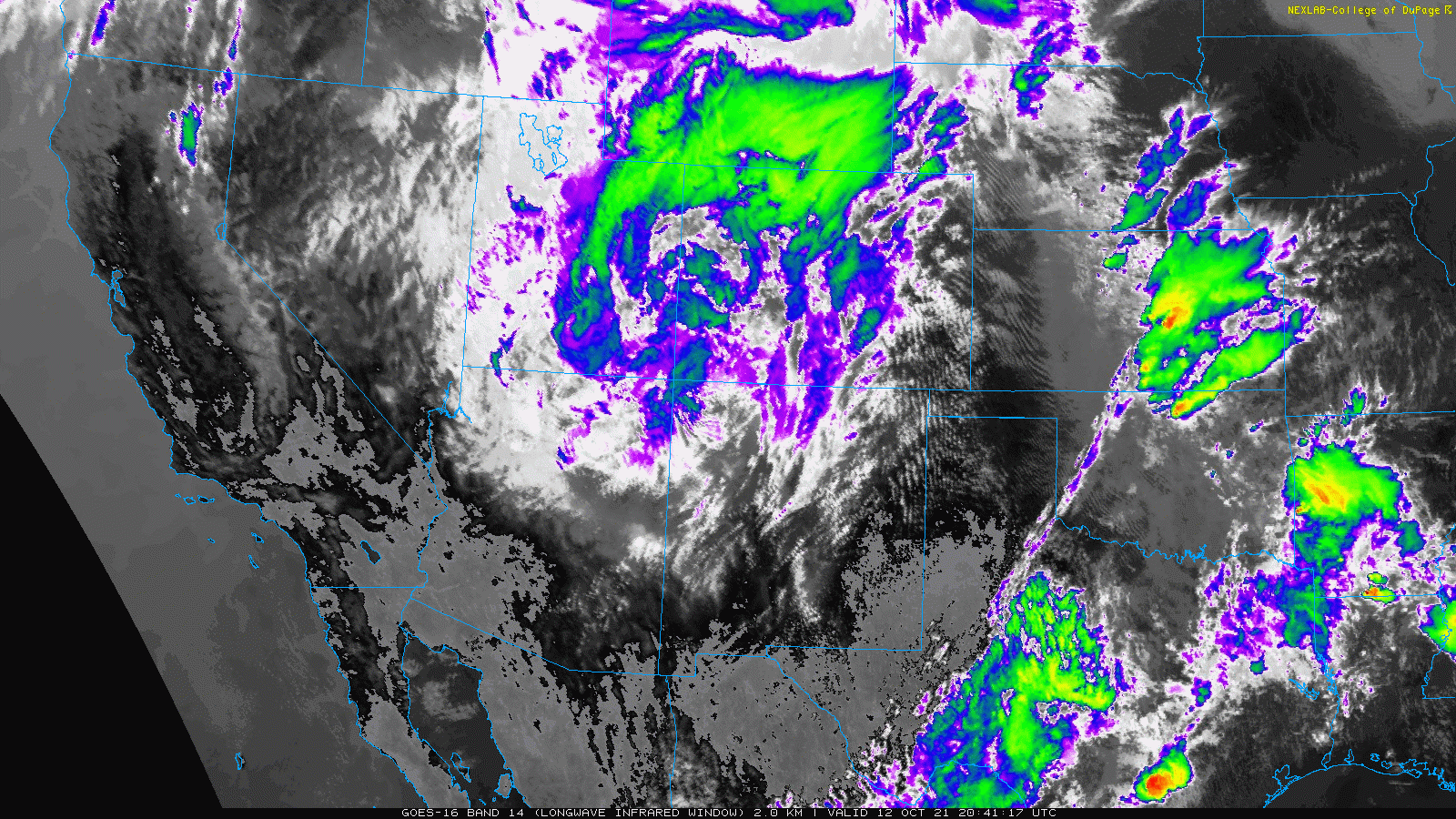
GOES-East infrared satellite animation from Tuesday night into Wednesday afternoon showing the storm system moving across Colorado
Closer to home in the Boulder area, things were technically quieter as the storm took an unfavorable track for us. However, right around sunset a line of thunderstorms bubbled up near Boulder and moved northeastward creating quite the scene! If you haven’t heard…the Denver weather radar was down the last few days for maintenance. As such, the Cheyenne radar animation is shown below. The line of storms is still clearly visible across the northern Front Range passing through Boulder around 1 UTC (7PM local time).
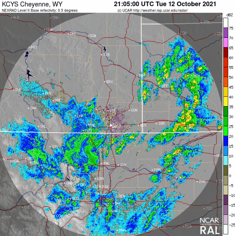
Radar animation from Tuesday evening showing the line of chilly thunderstorms that developed near Boulder and moved northeast
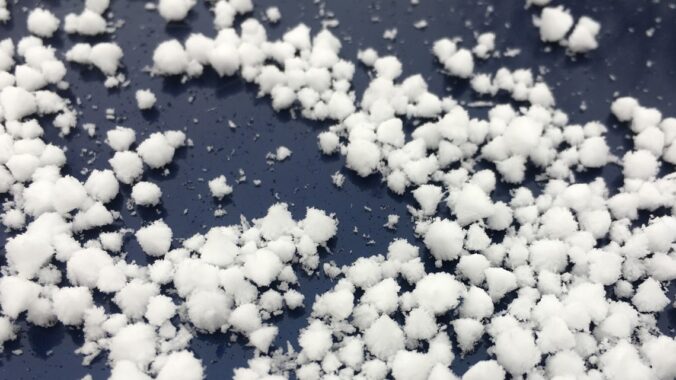
In addition to the impressive mid-October lightning show, temperatures were quite cold at the surface in the upper 30’s to middle 40’s as the storm passed by. This allowed graupel to reach the ground and accumulate in spots from Boulder to Lafayette to Longmont. Not to be confused with hail, graupel is a slightly less dense type of frozen precipitation that forms when snowflakes collect supercooled cloud droplets on their way to the ground. It’s somewhat of a hybrid between snow and hail, but isn’t really either of them. You can read more about graupel on Wikipedia if you are interested. We reported a thin layer of graupel at our station in north Boulder, but we saw photos shared from basically all over Boulder with accumulating graupel.
What accompanied last night's cold thunderstorm was graupel, not hail or snowflakes. However, graupel does technically count as snowfall. If you're area saw a coating of graupel last night like this (0.1"+), congratulations. You just had your 1st snowfall of the season! #COwx https://t.co/oBAJaUgGkF
— BoulderCAST Weather (@BoulderCAST) October 13, 2021
The question you might have is does this officially count as the city’s first snowfall of the 2021-22 season, especially if you have a vested interest in taking a prize in our 7th Annual First Snowfall Contest. Officially, yes. If the observers at the Boulder climate station near NIST on South Broadway were able to measure even 0.1″ of graupel somewhere on the ground or a snowboard, this would count as the first accumulating snowfall of the season for the city of Boulder! As of 6:00PM Wednesday, we still have not received official word on whether or not snow was reported Tuesday evening, but we should know soon!
UPDATE (6AM Thursday 10/14): No snow was reported in Boulder or Denver from this event. The first snow still eludes us!
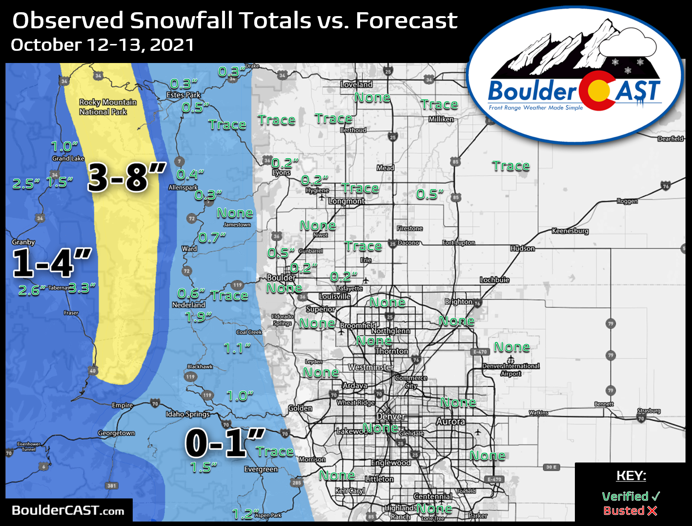
Our snowfall forecast map with overlaid observed snowfall totals for the first snow event of the season is shown below. The highest totals came from west of the Divide near Grand Lake (up to 3″). Mountain ski resorts like Loveland did receive more like 8″ of new snow. Who is ready for ski season? Across the Plains, a layer of graupel up to 0.5″thick was reported in parts of Boulder and Weld Counties.
A second chance at our first snow (if the first snow didn’t already happen)
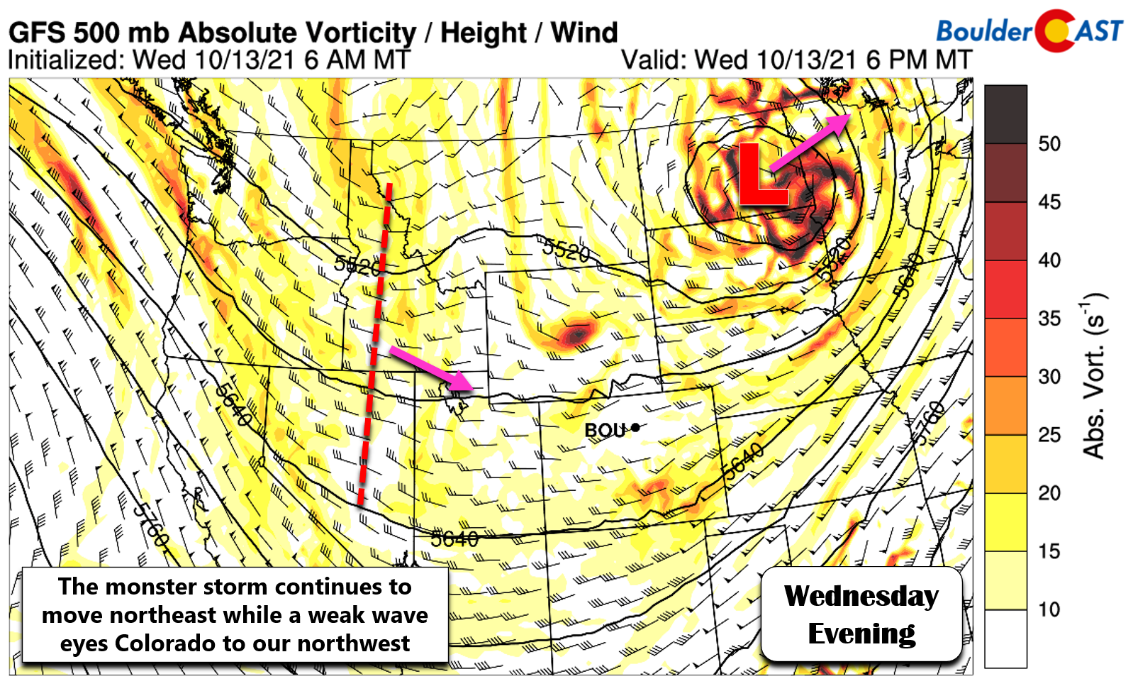
The monster low pressure responsible for the wild weather on Tuesday is departing towards central Canada as of Wednesday evening. However, back across Idaho a swift-moving shortwave disturbance is already taking aim on Colorado. It’s doesn’t look like much at the 500mb level in the atmosphere as shown below, but it does have a much more favorable track for the Front Range than the prior storm system. This disturbance, though weak and brief, will directly target the Denver area late in the day Thursday.
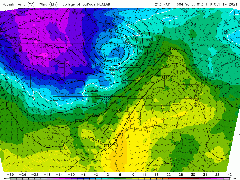
This secondary storm is notably much colder than the last. For this reason, we are fairly confident that many areas will see some snowflakes as it passes through the Front Range Thursday afternoon and evening, with rain at the onset mixing to some snow towards the tail-end of the short-winded event. This cold surge is also the reason we believe Friday morning will be the first widespread freeze of the season. The animation below shows a temperature forecast at 700mb. Watch as the purple and pink shadings are drawn into Colorado Thursday evening and Friday morning. -12°C air at 10,000 feet elevation will be over Boulder by early Friday. Brr!
This is certainty the coldest we’ve seen since late April or early May. It would be more than enough to turn rain to snow even across the lower elevations. That is, if there is any rain left to turn over. Models have trended quicker and lighter with this event over the last few days. Right now we’re seeing decent agreement between most of the high-resolution models that convective snow showers will develop across the Mountains early Thursday afternoon and then spread eastward across the Plains by late afternoon continuing into early evening. Temperatures will quickly cool into the 30’s but the precipitation wraps up rather abruptly around sunset in the high-resolution models. This timing is not great and would amount to little or no snow across the lowlands — some rain but mostly too warm for snow. Global models like the European and GFS are both showing a slightly slower storm with precipitation not even developing until early evening continuing for several hours after sunset. This delayed arrival would be better for accumulating snow but seems like a less likely scenario.
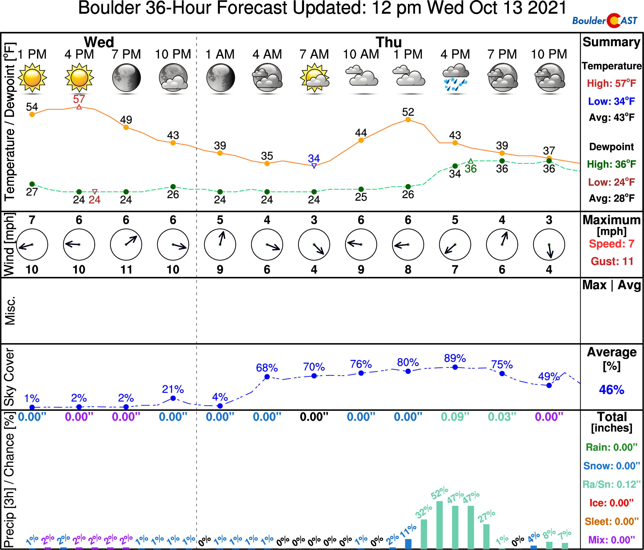
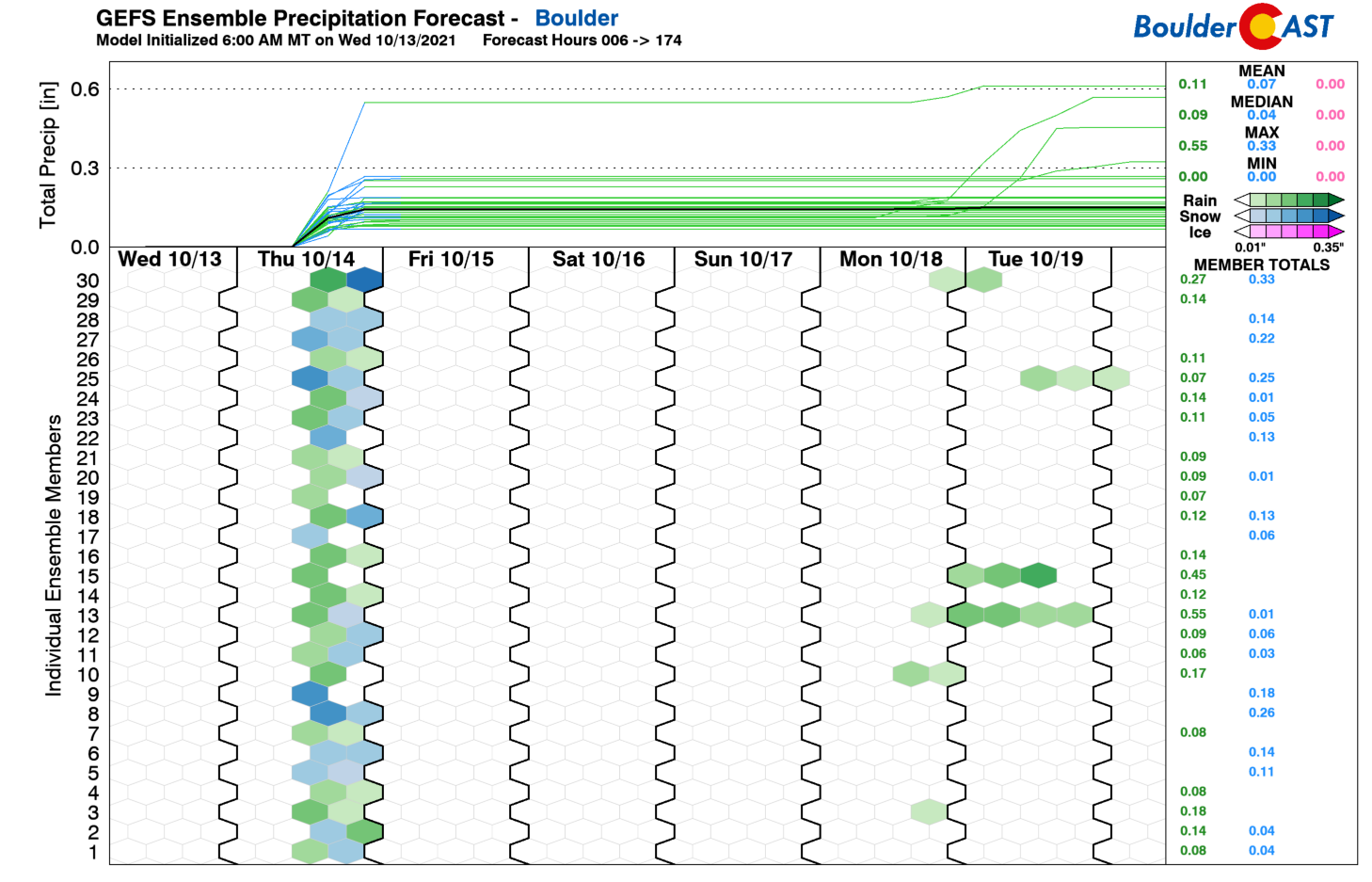
In general, models and ensembles are well-aligned with this system. It’s quick-moving so precipitation amounts will be on the light side no matter how you draw it up — probably 0.25″ or less of combined rainfall and melted snow equivalent. Worst case scenario, some areas could see an inch of slushy snow on the grassy surfaces, but that should be rare. The more likely outcome for most Front Range cities though would be rain mixing with a trace of snow, up to a dusting in spots. Anything more than that is unlikely again. Sorry snow enthusiasts!
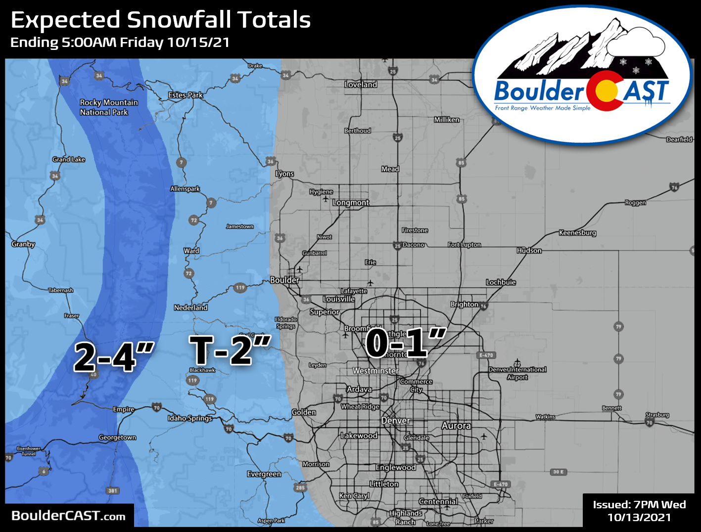
Our snowfall forecast map for the event is shown below which covers snow falling through Thursday night. Overall, the precipitation potential is fairly low, but the risk of some snow mixing in with the rain will be the story again as it could be the first flakes of the season in your area. Look for just spotty accumulating snow around Boulder and Denver, up to 1″ in the luckiest spots, but likely a dusting or nothing at all. Where temperatures will be colder in the Foothills, up to 2″ of new snow is possible. Lingering light rain/snow showers will end by the late evening on Thursday.
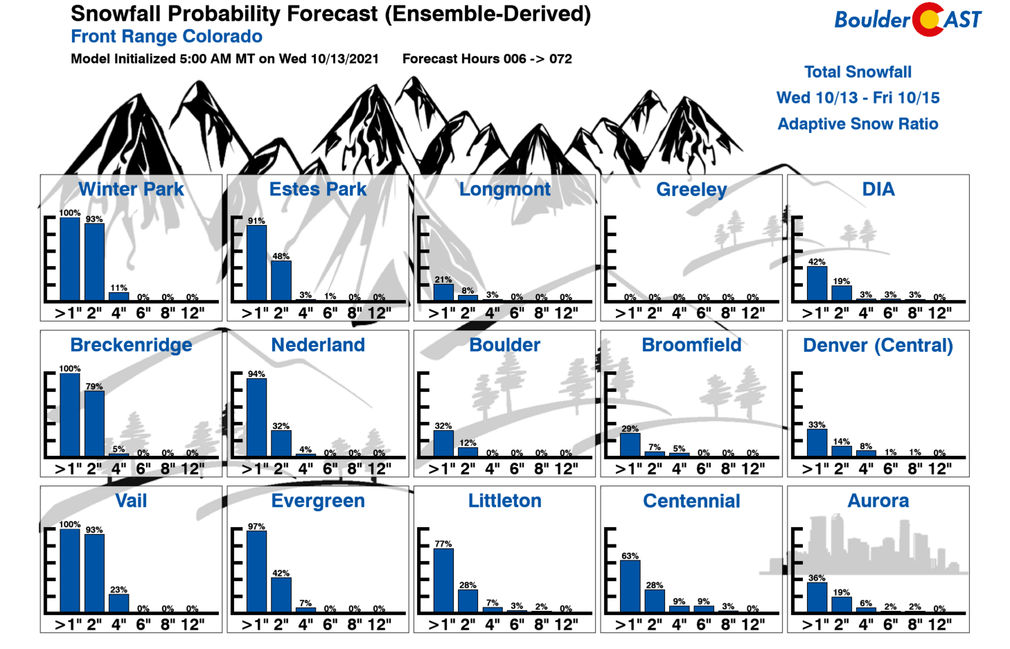
Here’s our latest Snowfall Probability Charts for your consumption as well. They tell largely the same story as our forecast map above, but additionally give a glimpse at the odds of various outcomes across the Denver Metro area.
As quickly as this shortwave moves in, it will exit Thursday night with skies projected to clear out well before sunrise Friday. This will open the door for the first widespread freeze of the season with temperatures dropping into the mid to upper 20’s in many locations. This is it folks! Harvest the sensitive crops from your gardens. Winterize your above ground pipes including hoses and irrigation backflows, and bring in those potted plants!
Friday will be chilly with temperatures reaching only into the lower 50’s, but dry and more seasonal weather will return for the weekend ahead.
Help support our team of Front Range weather bloggers by joining BoulderCAST Premium. We talk Boulder and Denver weather every single day. Sign up now to get access to our daily forecast discussions each morning, complete six-day skiing and hiking forecasts powered by machine learning, first-class access to all our Colorado-centric high-resolution weather graphics, bonus storm updates and much more! Or not, we just appreciate your readership!
.
Enjoy this content? Do us a favor and give it a share!
.


You must be logged in to post a comment.