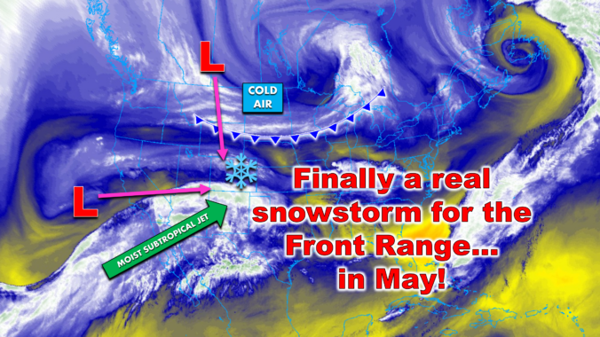
After another warm, spring weekend across the Front Range, big wintry changes are brewing for the days ahead! A surprisingly potent May storm is lining up for Colorado, and this one has all the ingredients to deliver a late-season deluge of precipitation. From deep moisture to prolonged upslope and a well‑timed blast of cold air, the setup is primed to be a high‑impact event — and yes, that includes heavy, wet late-season snow for all of us. We discuss the intriguing dynamics of the storm, the most likely snowfall amounts, potential impacts to our trees and power lines, and just how far we will drop below freezing.
What You Need to Know
- ❄️ Major May snowstorm incoming: A cold northern wave and a moisture‑rich California low will phase perfectly in the coming days, setting up a high‑confidence late‑season storm for the Front Range.
- 🌧️ Big moisture totals likely: Models are unanimous on 1–2 inches of liquid for Boulder/Larimer Counties with 1″ or so possible towards Denver.
- 🏔️ Foothills & mountains get hammered: 1–2 feet of heavy snow above 8,000 feet….with locally 30″+ possible on east‑facing slopes near the Divide.
- 🌡️ Lower elevations start warm: Rain dominates early Tuesday with snow levels near 7,500 feet before dropping below 5,000 feet by evening.
- 🌙 Tuesday night is the danger zone: Heavy, wet snow Tuesday night into Wednesday morning could fall at 1–2″ per hour at times, sticking efficiently to fully leafed‑out trees.
- 🌳 Tree damage & power outages likely: The setup strongly favors widespread limb breakage and power outages, likely worse than the May 2022 event which knocked out power for 100k Front Range residents.
- 📏 Snow totals down low vary: Boulder expected to see 5–10″, but 2-7″ totals elsewhere in the Denver area.
- 🥶 Hard freeze risk: Lows Tuesday night drop to 28–31°F, with potential for colder temps Wednesday night if skies clear.
- 🌞 A quick warm-up and nicer weather the rest of the week: Back to the 70s by Friday

Go Premium, get all the perks.
Daily Forecast Updates
Get our daily forecast discussion every morning delivered to your inbox.
All Our Model Data
Access to all our Colorado-centric high-resolution weather model graphics. Seriously — every one!
Ski & Hiking Forecasts
6-day forecasts for all the Colorado ski resorts, plus more than 120 hiking trails, including every 14er.
Smoke Forecasts
Wildfire smoke concentration predictions up to 72 hours into the future.
Exclusive Content
Weekend outlooks every Thursday, bonus storm updates, historical data and much more!
No Advertisements
Enjoy ad-free viewing on the entire site.
Late-season damaging snowstorm inbound
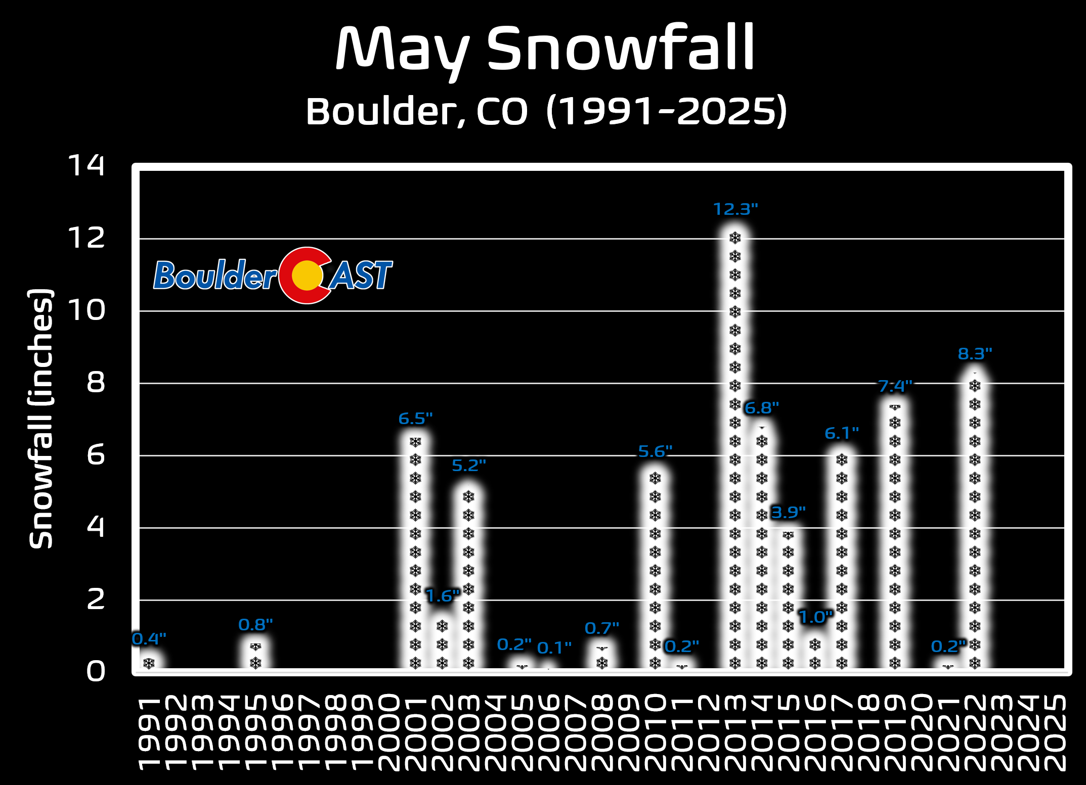
After a picture‑perfect weekend in the 70s across the Front Range, the atmosphere is about to snap us straight back into late‑season winter. A complex, moisture‑loaded storm system is lining up to deliver accumulating snow to the Denver-Boulder during the first week of May. While much of the country has already mentally shifted to summer (and many of us have too), May snow along the Front Range is far from rare — Boulder has logged measurable May snowfall in 16 of the last 25 years, and our last big May event in 2022 dumped more than 8 inches in town with widespread tree damage. Unfortunately, the setup this week carries many of the same red flags.
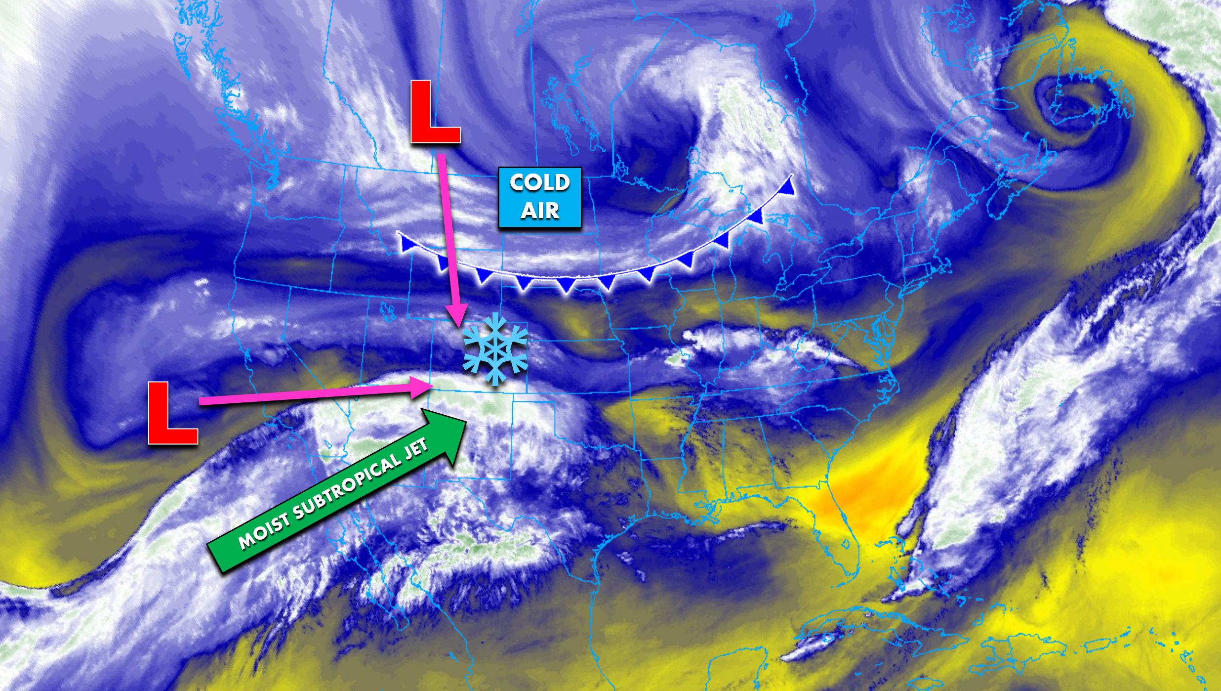
What makes this storm particularly fascinating is how closely it mirrors the atmospheric pattern from the storm just a few days ago, the one that fizzled spectacularly and left Denver and Boulder with little more than sprinkles. That system relied on a delicate phasing between a cold northern trough and a moisture‑rich cutoff low from California. The phasing never clicked, the upslope never materialized, and the event collapsed. The models were trending downward for days, and the writing was on the wall early. Hindsight is 20/20, though.
This time, the atmosphere is running the same playbook — but the execution looks dramatically different. Instead of trending downward, every major model and every ensemble member is locked into a wetter, colder, more impactful solution, and confidence is rising quickly that this will be a high‑end precipitation event for Boulder and Larimer Counties. With temperatures cold enough for a large portion of the storm to fall as heavy, wet snow, the threat to our fully leafed‑out trees is growing by the hour.
Atmospheric Déjà Vu — But With a Much Better Setup
The same two‑wave structure from our last storm is back:
- A cold northern‑stream trough will dive straight into Colorado from western Canada, supplying the cold air needed to flip rain to snow even at lower elevations, far from an easy task in the month of May!
- A closed low over California will drift east, dragging a plume of Pacific moisture along the subtropical jet.
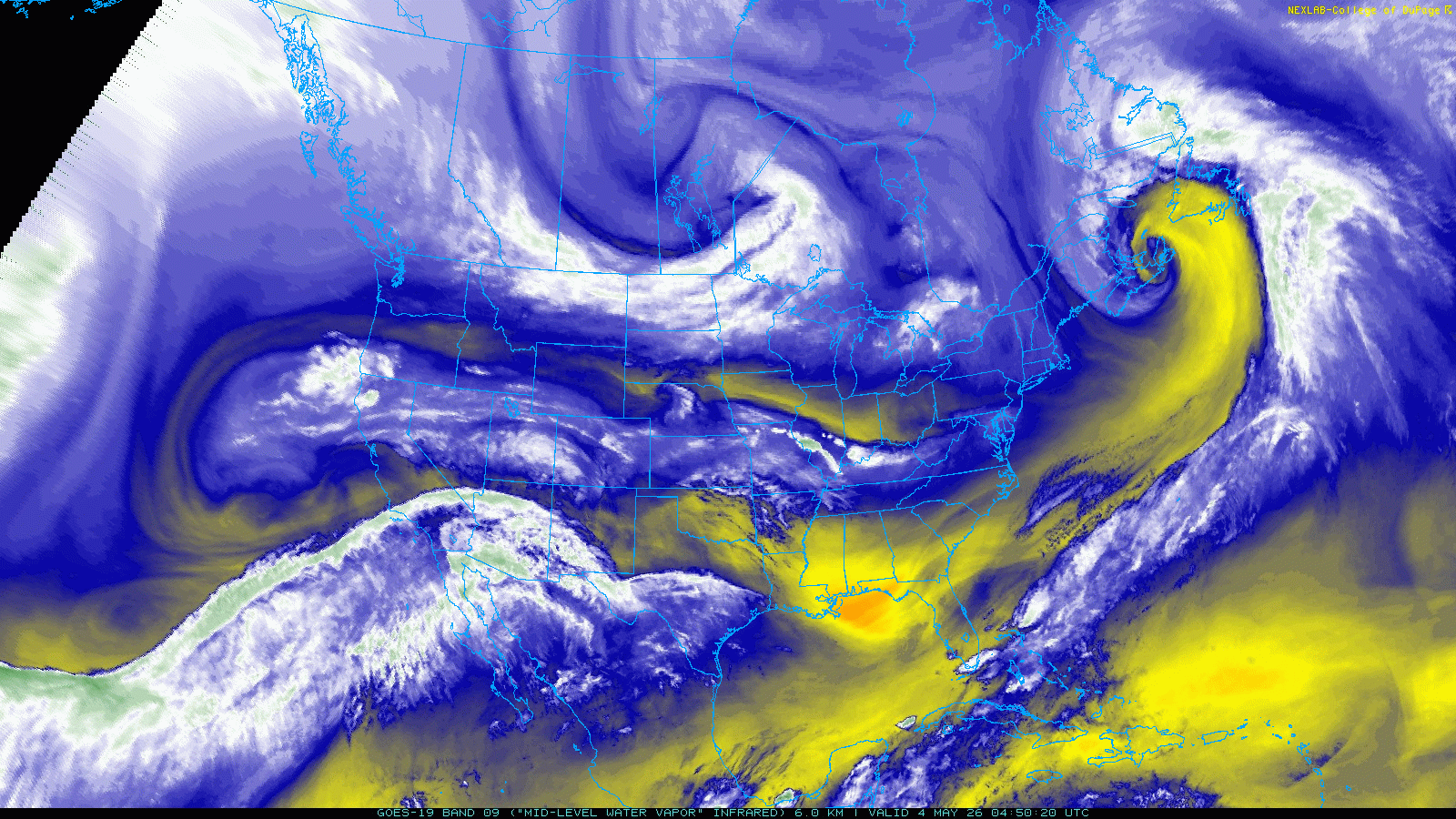
GOES-East water vapor animation from Monday morning. Can you spot the two waves set to meet up over Colorado?
The forecast animation below of 500mb height and vorticity shows how these two features will phase together over the next 48 hours. This time, the phasing is projected to occur right over Colorado Tuesday night, a far more favorable location for deep, sustained upslope and large-scale lift along the Front Range.
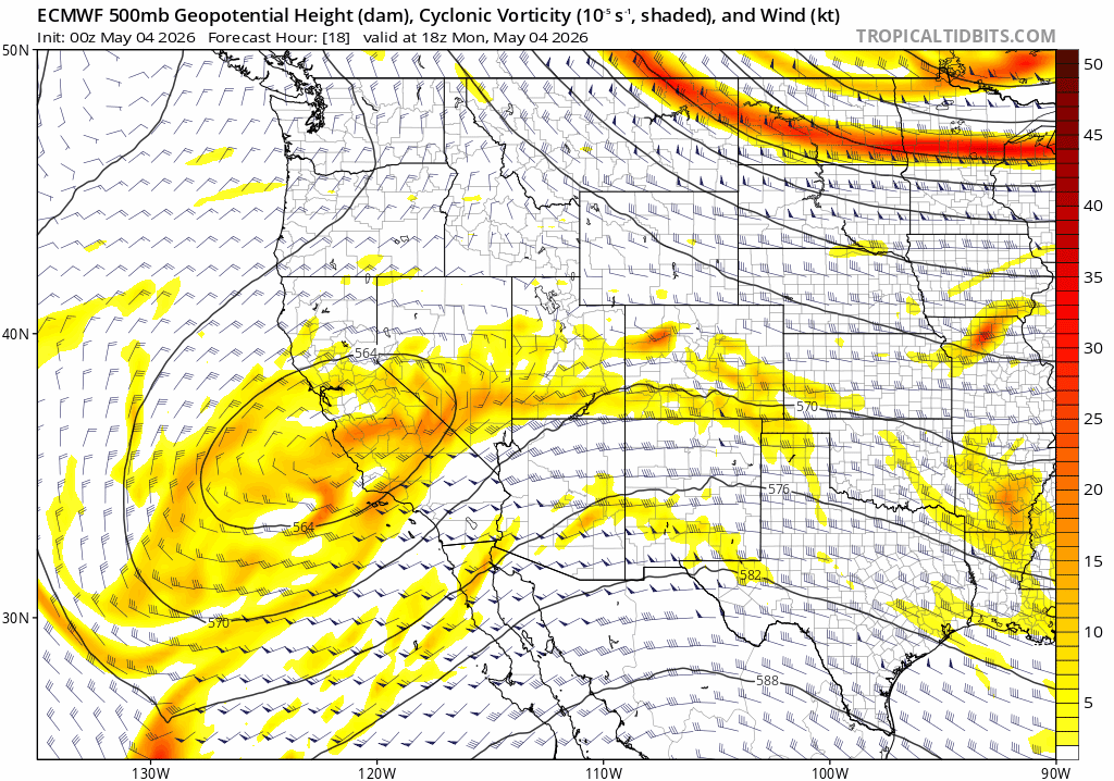
Euro 500mb height and vorticity forecast animation for Monday through Wednesday showing the waves phasing
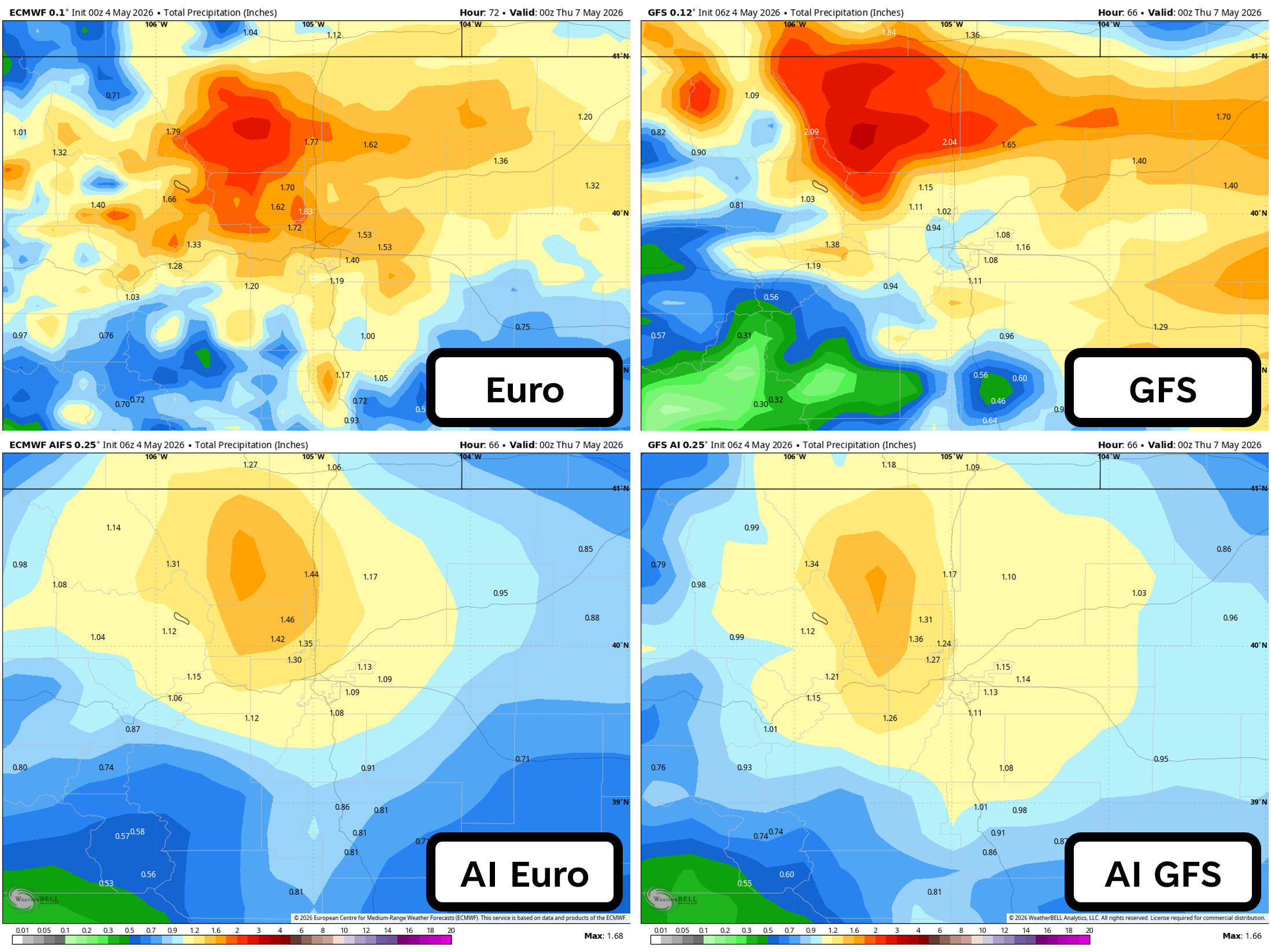
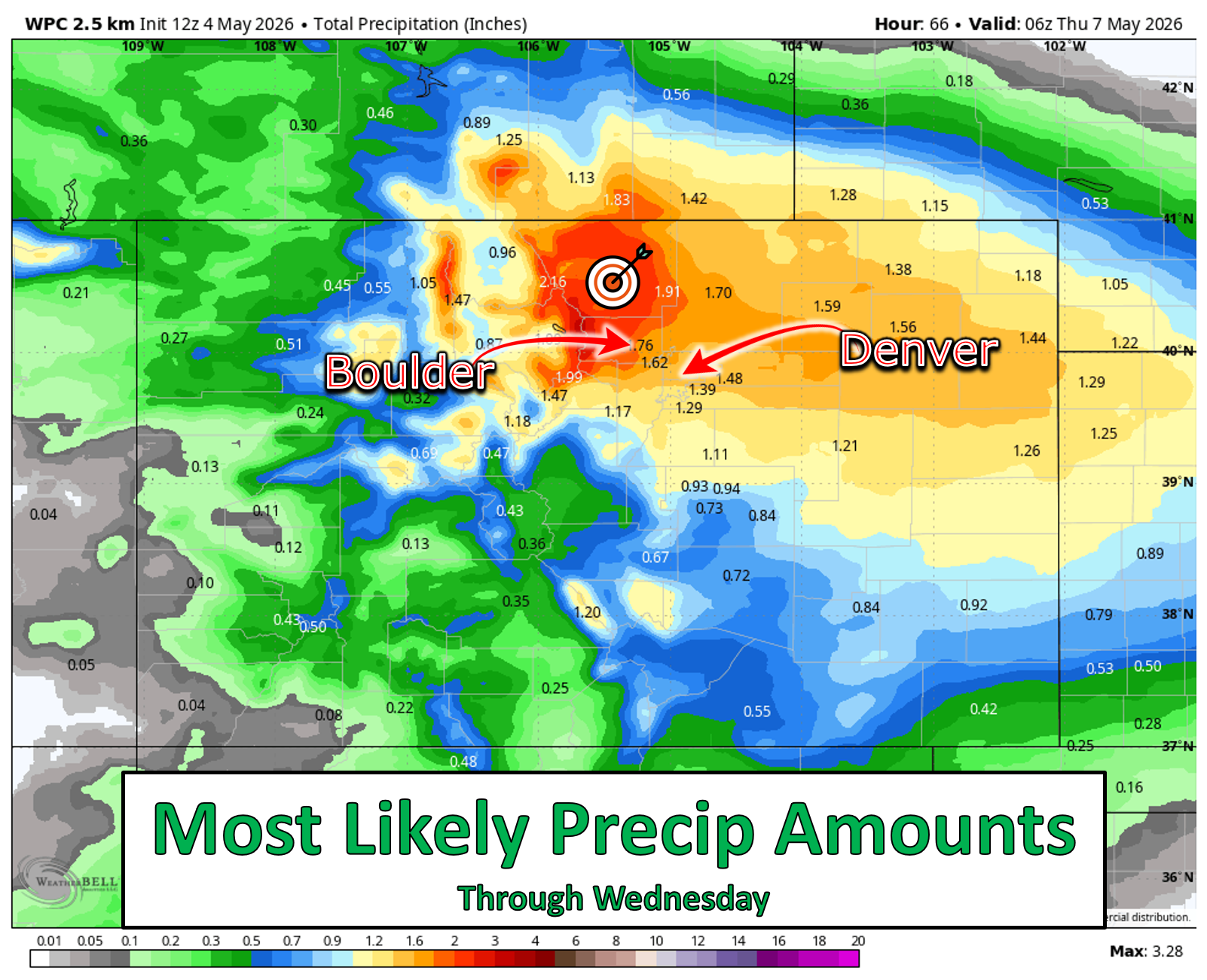
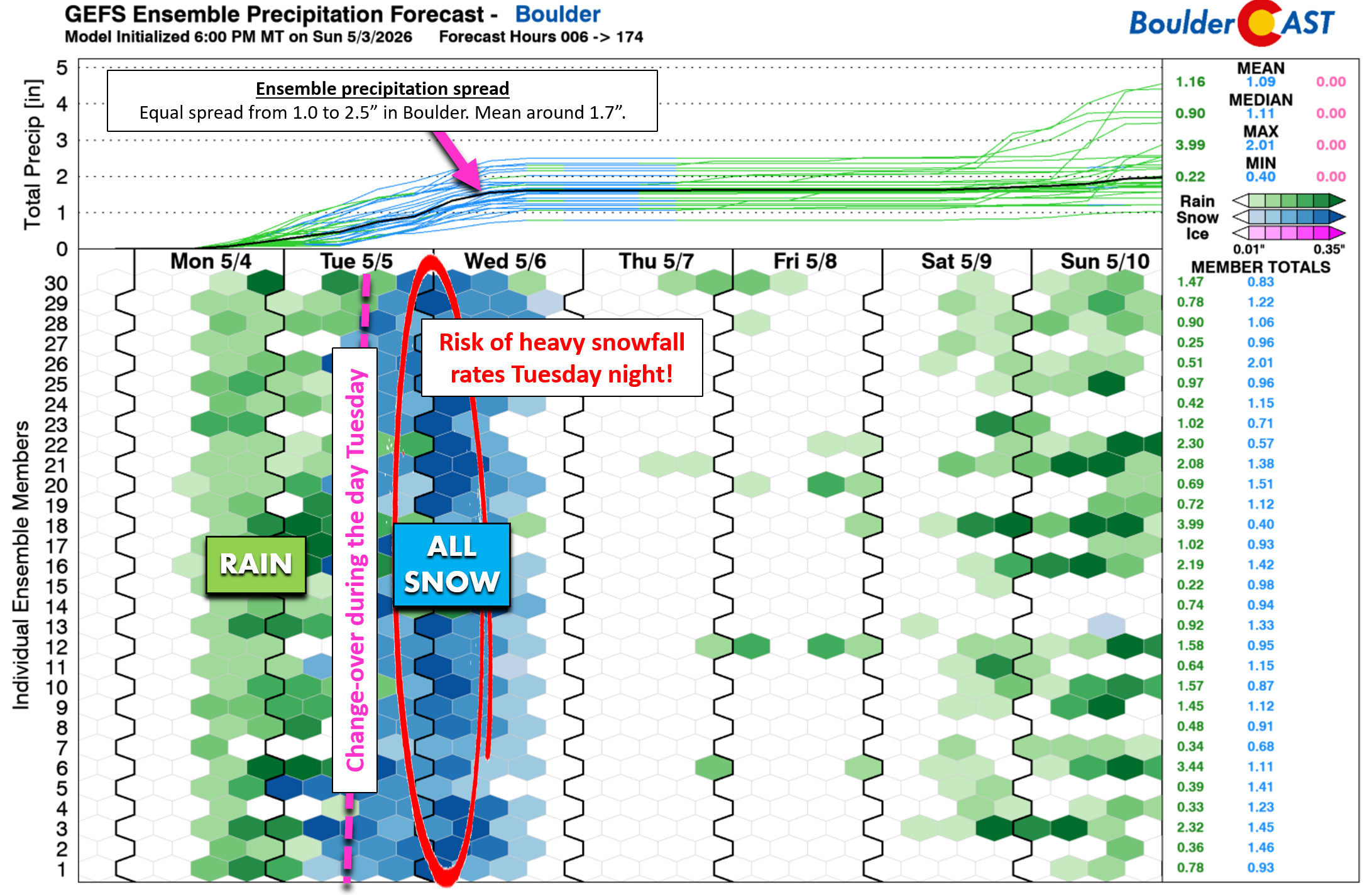
In an effort to not sound like the meteorologists that cried wolf, it’s important to understand that confidence is much higher this time around in the overall footprint and general dynamics of the impending storm. This will be a significant precipitation event for the Front Range, with confidence growing that between 1 to 2 inches of liquid is on the table for Boulder and Larimer Counties, with a lesser but still real chances for much of the Denver Metro area to top 1″ as well. The European ensemble forecast paints a bullseye of around 1.5 to 2 inches from Boulder to Fort Collins westward to the Divide.
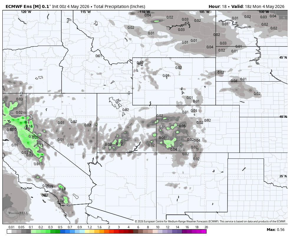
At this point Monday morning, it’s not just a few outliers that on board for this deluge of precipitation. Essentially every deterministic model and every single ensemble member is locked into this forecast and has been for a while now. The Foothills and Mountains of Boulder and Larimer Counties are in for a significant late-season snowstorm, with snow totals of 10 to 20 inches highly likely above 8,000 feet elevation, with locally higher totals possible. Exact snow amounts and impacts for the warmer lower elevations are still being determined, and will be discussed in great detail below.
Four major ingredients are driving this high‑confidence precipitation signal:
- Large-scale lift from the converging shortwaves which will be in-place much of Tuesday and Wednesday.
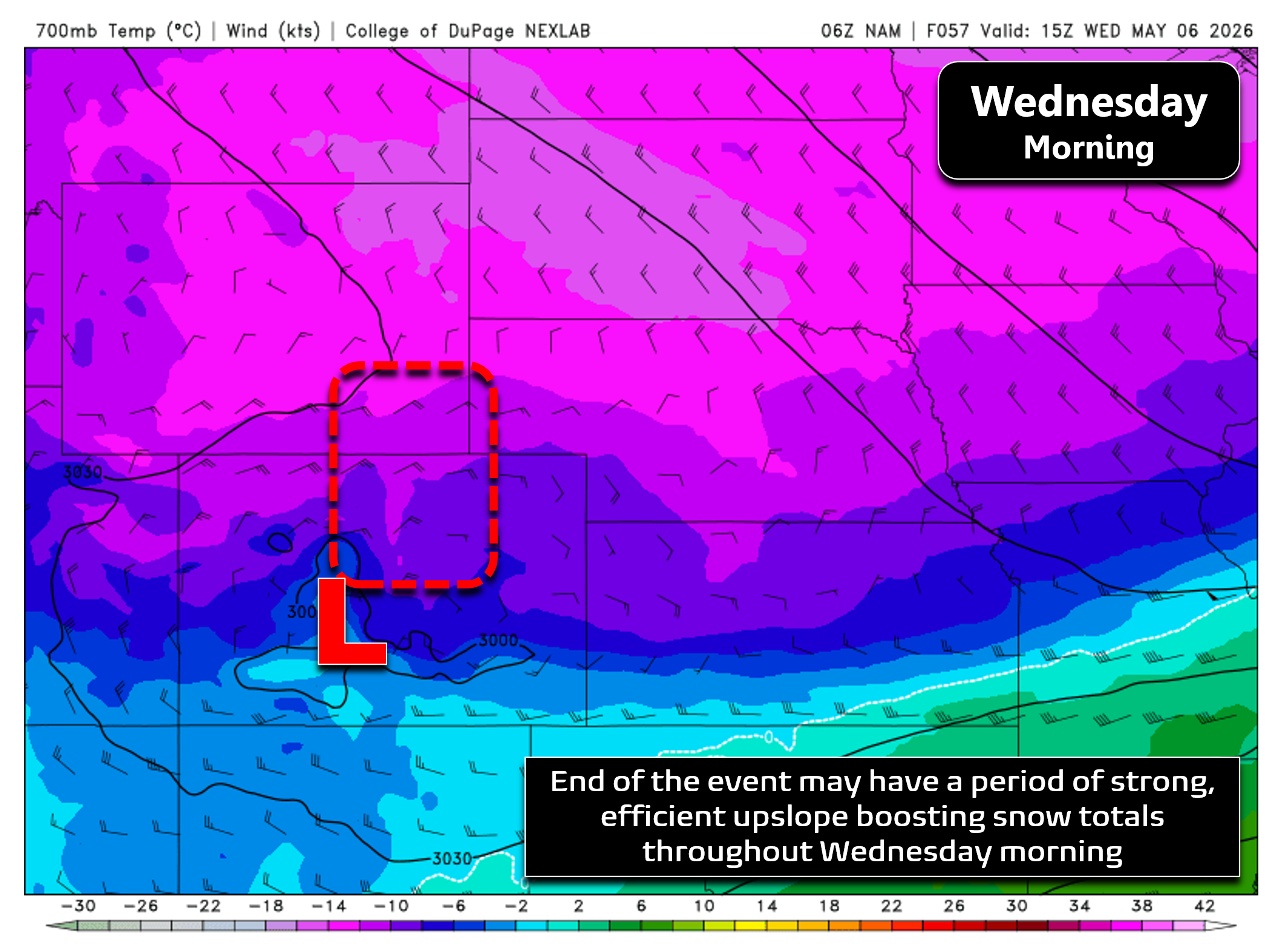
- Deep upslope flow generated by easterly winds reaching up to around 600mb, higher than the peaks along the Continental Divide. The best upslope takes shape around late-morning on Tuesday lasting more than 24 hours into Wednesday afternoon. While still uncertain, a mid-level closed low may develop across western Colorado Tuesday night, further enhancing upslope intensity and efficiency (i.e. the easterly component) into the Boulder County area.
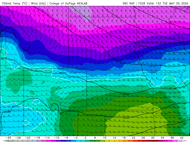
700mb temperature and wind forecast animation from the RAP model for Tuesday into Wednesday. Cold air and upslope settle into the Front Range.
- A stalled frontal boundary near Denver acting as a persistent focus for lift.
- Lift from the left exit and right entrance regions of two nearby jet streaks that will be sweeping through late Tuesday into Wednesday.
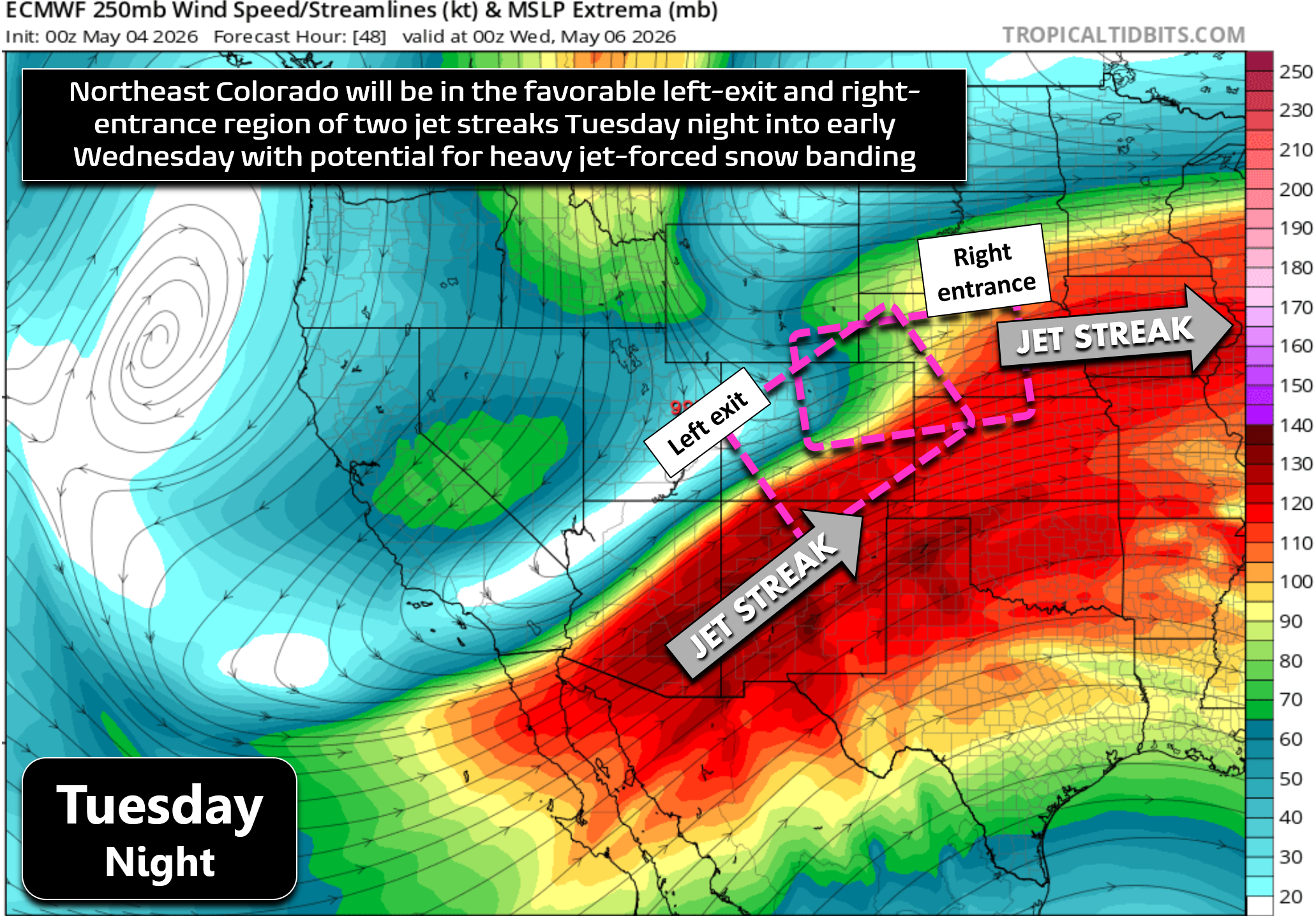
All of these factors contribute to what is now a fairly high-confidence forecast in terms of overall precipitation output for the Boulder-Denver area, as well as snow amounts in the higher terrain where temperatures will be plenty cold enough for snow to fall and accumulate. The 1 to 2.5 inch bullseye this week will be on Boulder and Larimer Counties, with Denver still very much in the mix for over 1 inch of moisture.
Lower Elevations: The Big Wildcard
The biggest question right now is what exactly will unfold across the lower elevations where temperatures, both ground and air, will be markedly warmer throughout the event. To start, we expect precipitation to begin late in the day Monday in form of scattered showers and some thunderstorms ahead of a cold front. After reaching the lower 70s, rain chances will creep up Monday afternoon before increasing further Monday evening. Still, precipitation will be somewhat hit or miss on Monday with lots of dry time between any of the passing showers or weak storms.
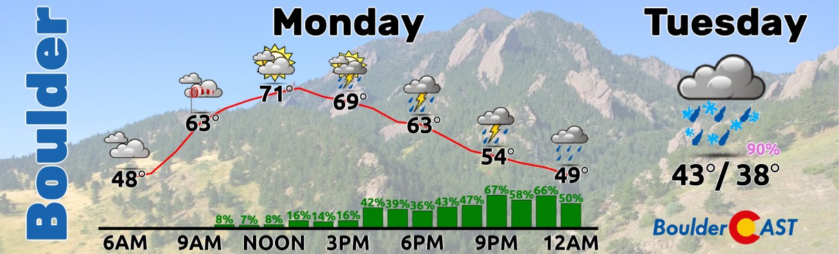
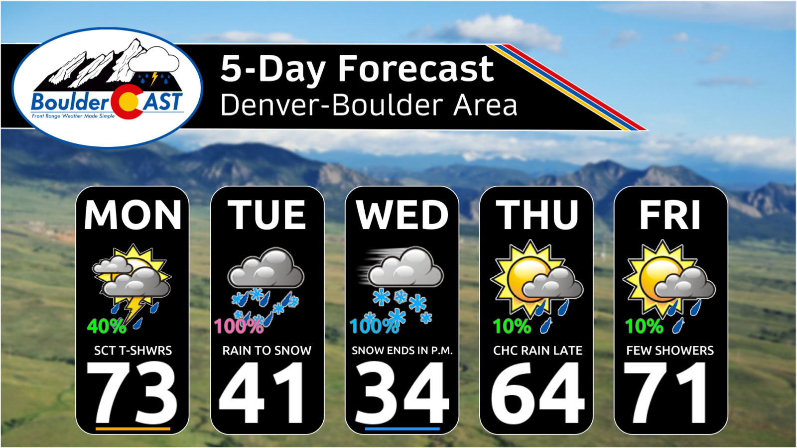
Note that whatever transpires on Monday is only a small appetizer for the main course coming Tuesday into Wednesday. Monday night an initial cold front will move through and that’s when a bulk of our precipitation will begin in the hours following sometime Tuesday morning.
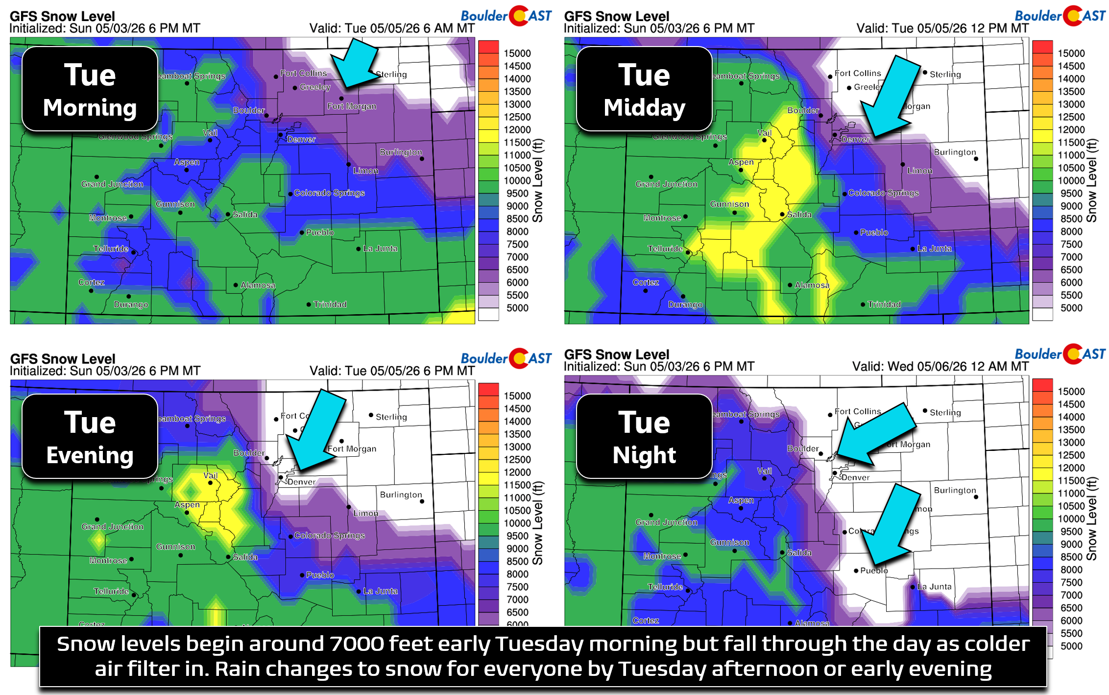
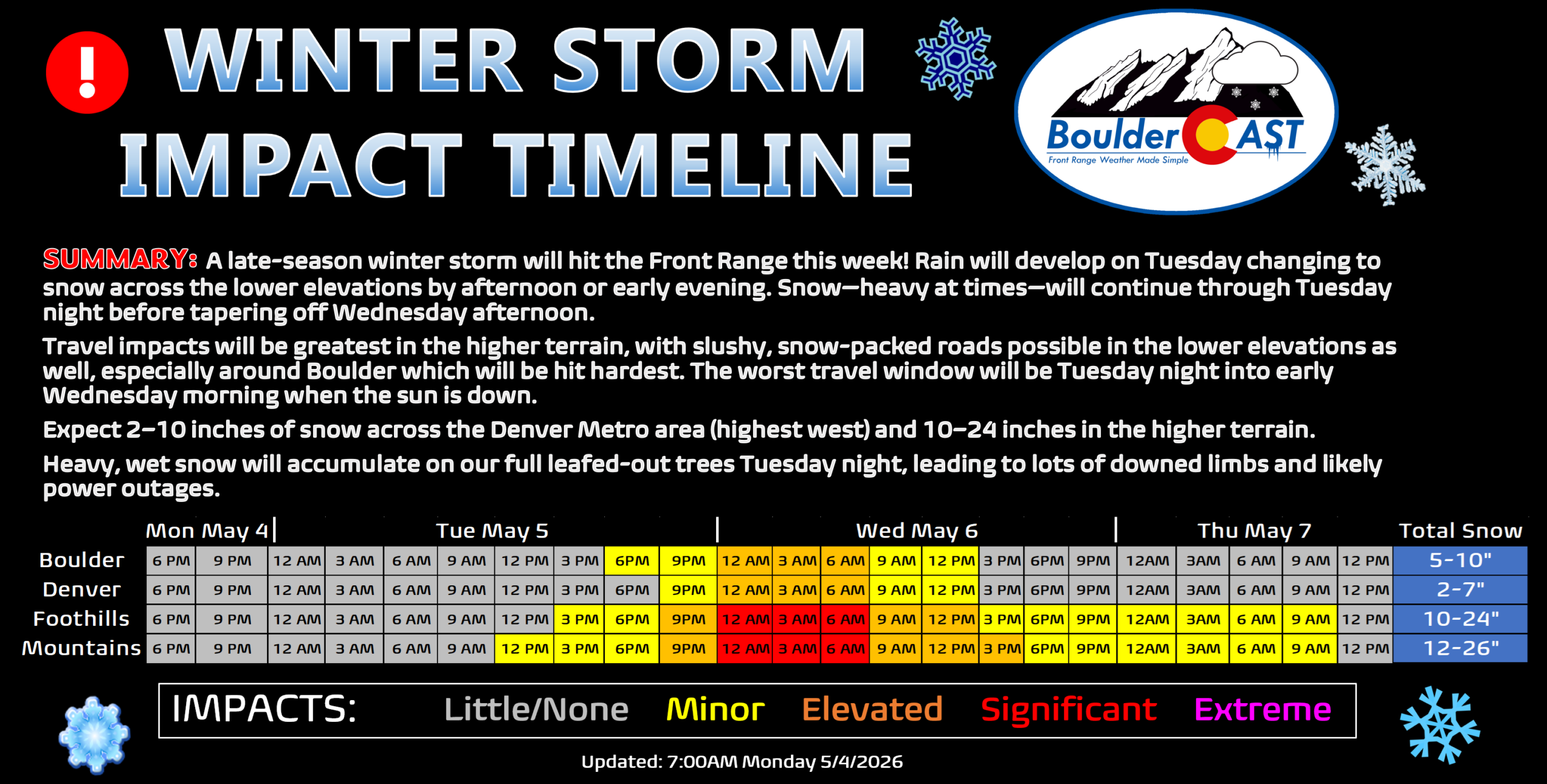
Snow levels will initially be around 7500 feet Tuesday morning but will fall through the day as cooler air filters in from the north and east, eventually bottoming out below 5000 feet Tuesday evening and night. While the Foothills above 7500 feet will see almost entirely snow from this event, the lower elevations and lower Foothills will begin as rain. As snow levels drop during the day Tuesday, everyone will make the change-over to snow and it will stay snow throughout the remainder of the event well into Wednesday. Most of the Denver Metro area will see some 18 to 24 hours of largely continuous wet snow, potentially some of that being very heavy snow at times.
This time of year, so late in the snow season, the May sun is very strong and will make accumulation during the daytime hours difficult for Boulder and Denver. Unless there is significant snowfall rates, the May sun tends to win out, limiting accumulation to grassy surfaces and only minor accumulation at that, with roadways staying just wet. However, another critically concerning aspect of the impending storm is how much of the event will occur during low-angle sun or overnight hours. While a good chunk of the moisture will fall during the day Tuesday as rain or melty snow, with minimal to no travel impacts, a similarly large chunk is shaping up to occur Tuesday evening into Wednesday morning when the sun will not be around to melt things off and offer its protection to roads and vegetation.
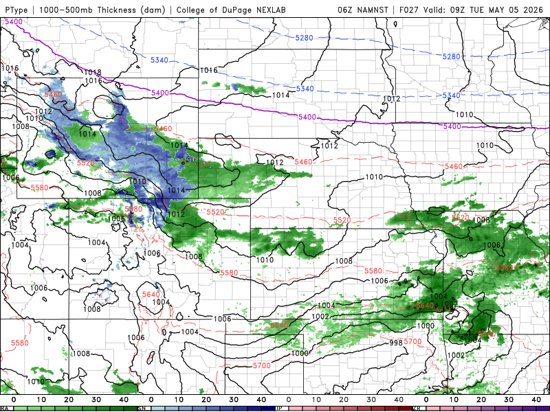
Precipitable and type forecast animation from the NAM-NEST model capturing most of the event with rain changing to wet snow in the Denver area.
Furthermore, this overnight period of time is when we expect all of the storm ingredients to overlap most effectively, with hours on end of potentially heavy snowfall rates aided by deep upslope, frontogenesis and the nearby jet streaks. Embedded bands with snowfall rates of 1 to 2 inches per hour could intermittently occur Tuesday evening into Wednesday morning and all of this will be sticking to the fully leafed-out trees. This is definitely shaping up to be a nasty recipe for widespread downed tree limbs and power outages, especially for areas west of Interstate 25 and north of Interstate 70.
Snowfall Amounts
As for snowfall amounts, they remain tricky to predict ahead of this complex storm where juicy springtime moisture will meld so intricately with the chill of winter. Let’s start with the easy part first….
The forecast in the Mountains and Foothills is fairly straightforward. Heavy spring snow is inbound and lots of it for the higher terrain, with totals easily exceeding 10 inches above 7500 feet in Boulder and Larimer Counties owing to a near perfect atmospheric setup that will linger and very cold temperatures that will support snow ratios more commonplace in February than here in May (perhaps up to 15-to-1 at the coldest part of the storm late Tuesday night). 10 to 20 inches will be widespread in these areas, with locally over 30 inches not out of the question for the east-facing slopes just east of the Continental Divide (Larimer is most favored).
For the lower elevations, it’s a much more difficult forecast. We’re not expecting much in the way of accumulation during the daytime hours Tuesday — the early May sun is quite the deterrent. The change-over to the white stuff should occur sometime in the afternoon hours or early evening at the latest, but there will be lots of melting with accumulation staying confined to the grassy surfaces early on. We’re thinking maybe a dusting to 2 inches by the time the sun starts to head down. Tuesday evening into Wednesday morning is when a bulk of the lower elevation accumulation will occur — and it could be substantial in some areas. Boulder is in the bullseye for this storm (or just a tad south of it), and we’re expecting 5 to 10 inches here. This heavy area of snowfall will extend northward to Fort Collins and west of Interstate 25. Areas further south and east, including most of the Denver Metro area, can expect a few inches of wet accumulation as well. Here we are predicting 2 to 7 inches, highest in areas above 5500 feet. Our preliminary snowfall forecast map for the event is given below.
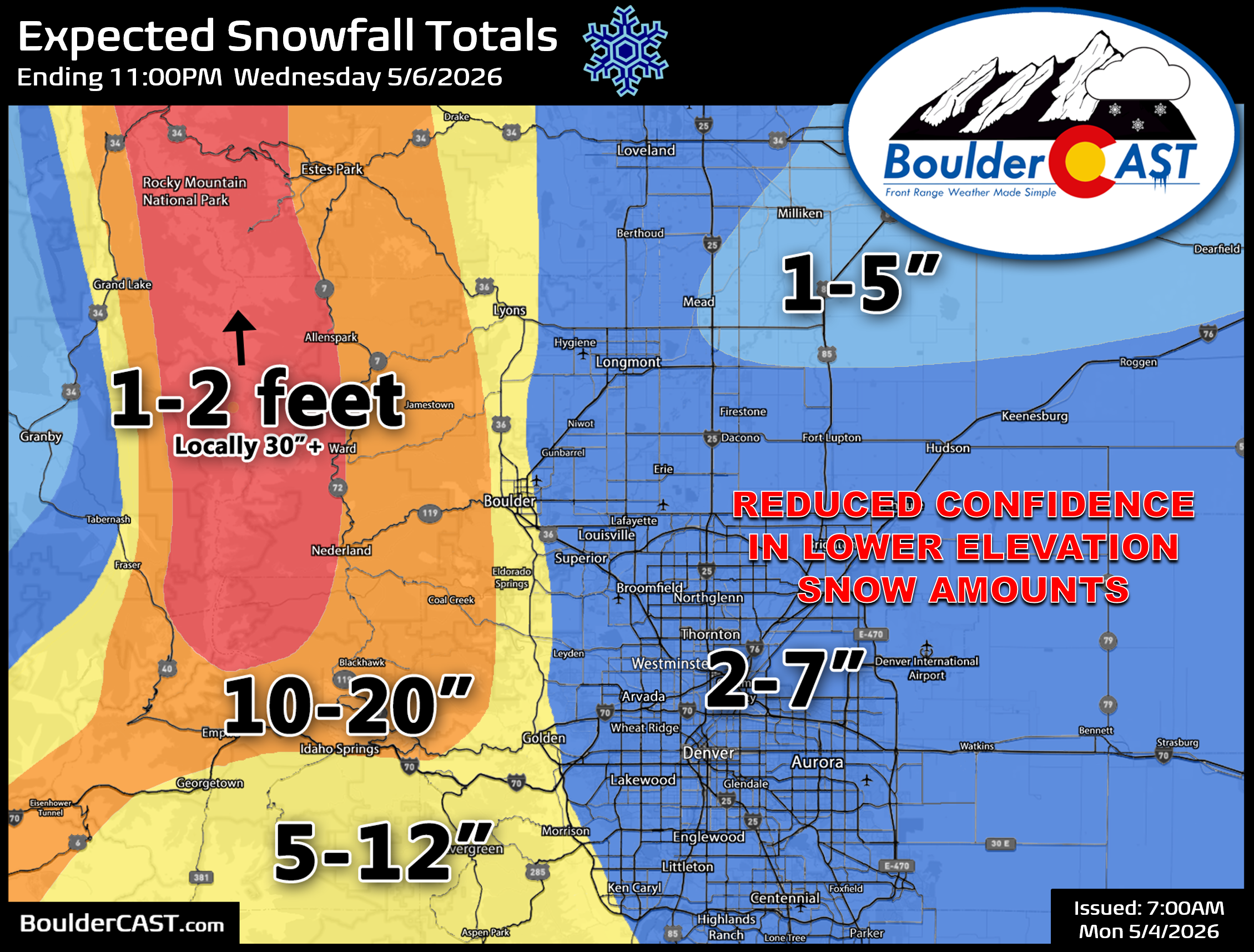
Snow will end during the day Wednesday, with models still teetering on the exact timing for when things will fully shutdown, largely dependent on the potential formation and movement of a mid-level low in western Colorado which will be controlling our upslope and frontal forcing. Snow will likely be around most of the morning Wednesday, coming to an end sometime in the afternoon hours. With the rise of the strong May sun again, melting will quickly ensue clearing off any slushy roads and hopefully helping out the trees a bit. Additional accumulations during the day Wednesday will mostly occur in the morning hours when the sun is low, maybe up to a couple more inches across the lower elevations. However, conditions should be improving during the day.
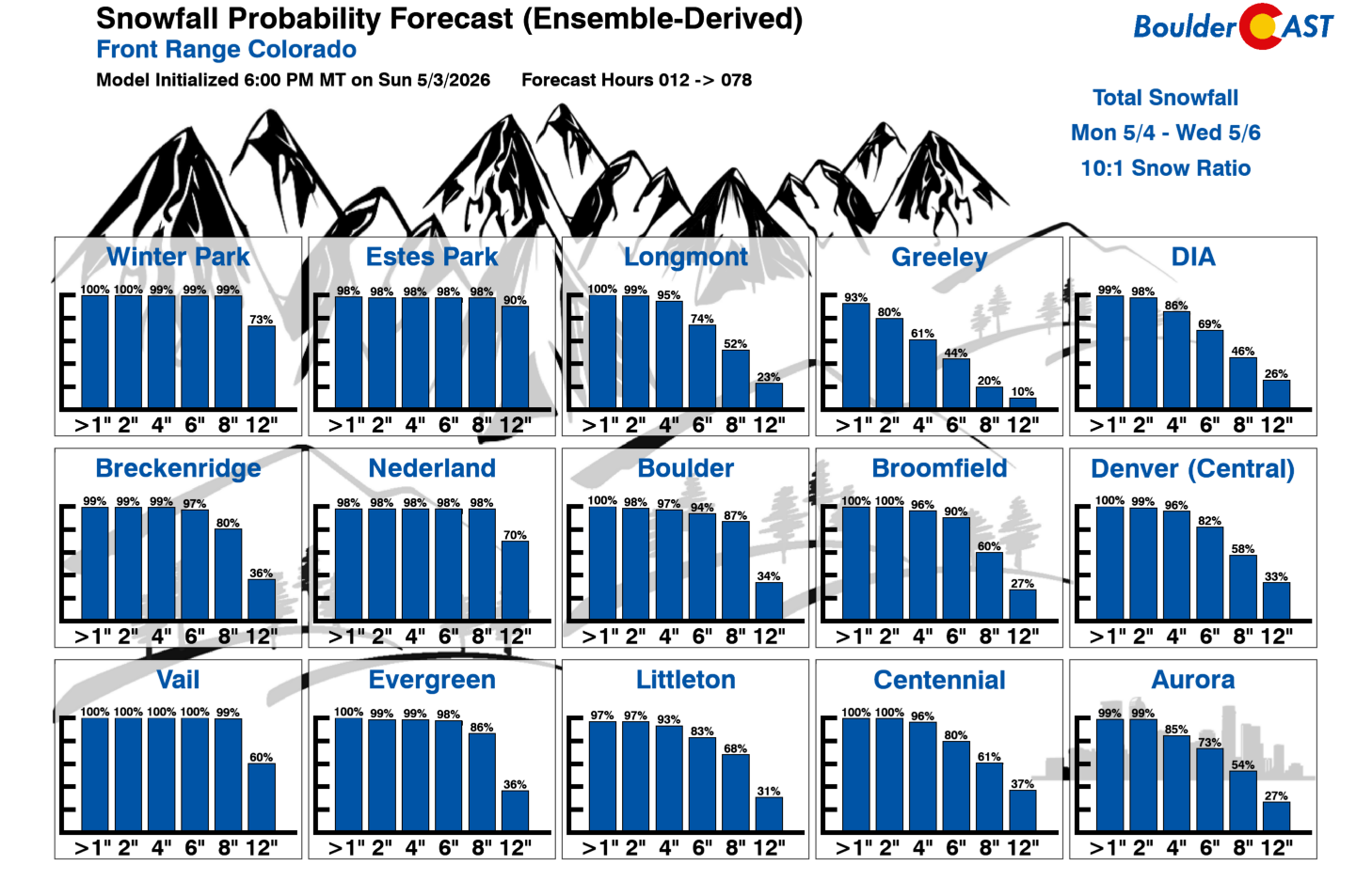
Take our latest Snowfall Probability forecast below with a decent-sized grain of salt. Models are notoriously bad with snow ratios in these type of warm, shoulder-season snow events.
Overall Impacts
Travel will begin to deteriorate in the higher terrain as early as Tuesday afternoon, with impacts spreading across the lower elevations Tuesday evening and night. We’re not expecting significant travel impacts for the lower elevations as road temperatures are very warm, but thick sludge or slush on the roadways is likely in areas that see 4 inches or more of accumulation. This includes the Boulder area. Tree damage is likely to be significant Tuesday night into early Wednesday, with lots of downed limbs and resulting power outages. The most recent late-season snowstorm of similar size in May of 2022 knocked out power to over 100,000 customers in the Denver area, and that storm’s snow fell largely during the daylight hours. This storm’s nighttime dump could be much worse.
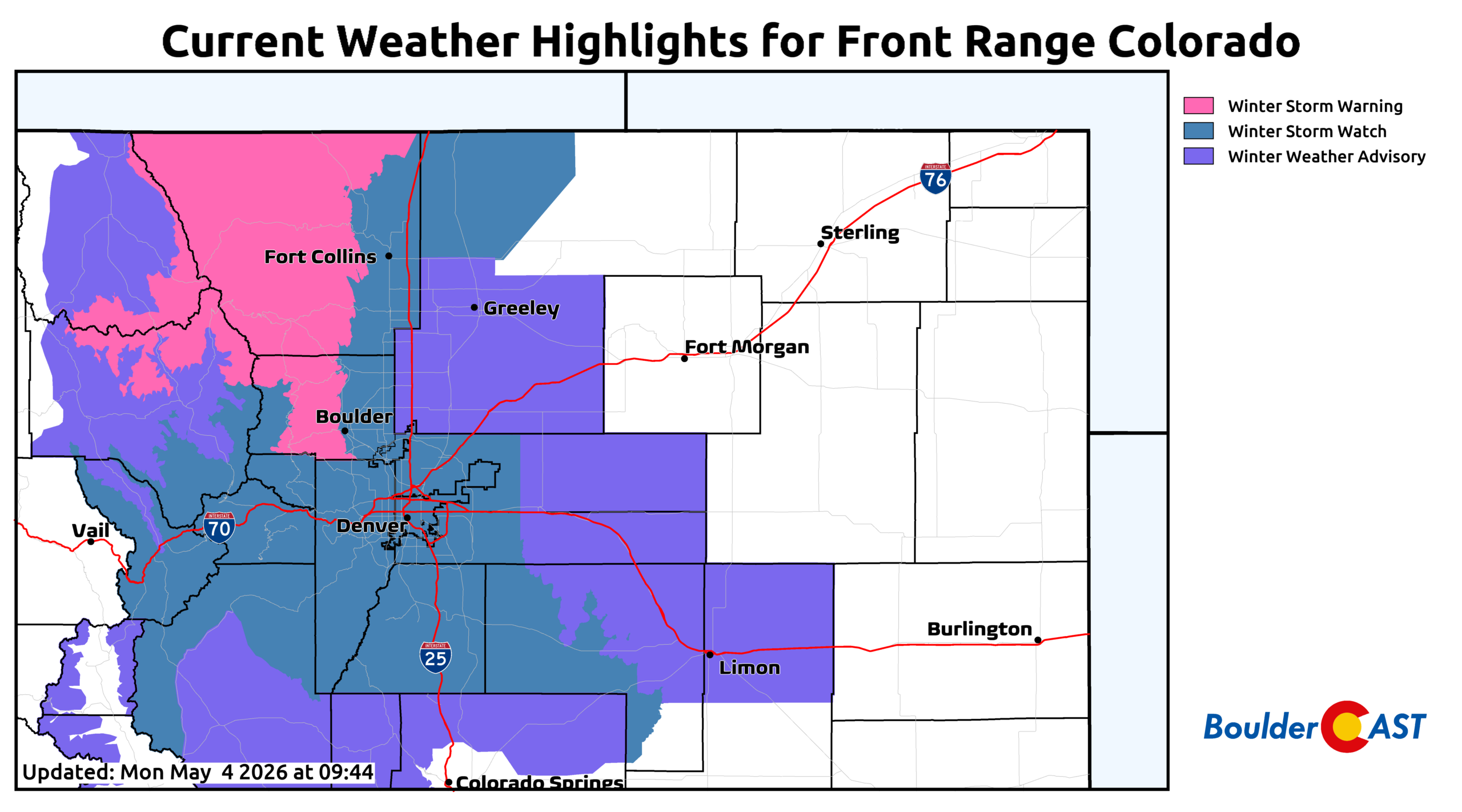
As of the time of writing Monday morning, Winter Storm Watches are posted for Boulder and Denver, with Winter Storm Warnings in the northern Foothills and Mountains. Boulder will probably get upgraded to a Warning as well, with Denver likely falling to Advisory status, but that’s just our opinion for now. The lower elevation forecast is particularly uncertain and could shift before the first flakes start falling on Tuesday.
What We’re Still Watching Closely
Here’s a few things we’ll continue to watch over the next 24 hours as our storm moves in, some of which could sway the forecast higher or lower…
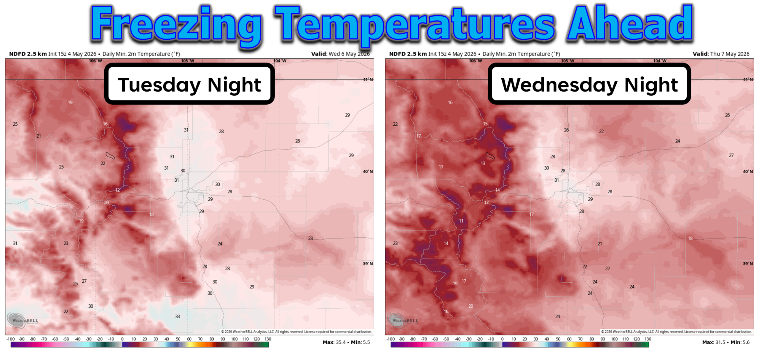
- Freezing Temperatures: Sub-freezing temperatures are expected from Tuesday evening into Wednesday as snow falls and again Wednesday night. We’re looking at overnight lows ranging from 28 to 31°F Tuesday night. Cloud cover and falling melty snow will limit how cold we can get this first night. The storm system is expected to pull out relatively quickly Wednesday night, with skies potentially clearing. This may allow temperatures to drop further into the 20s but this remains a bit uncertain. Above ground pipes should be drained for this event, and sensitive plants should be covered or brought indoors if possible. The wet snow may help insulate some ground plants, but don’t count on it!
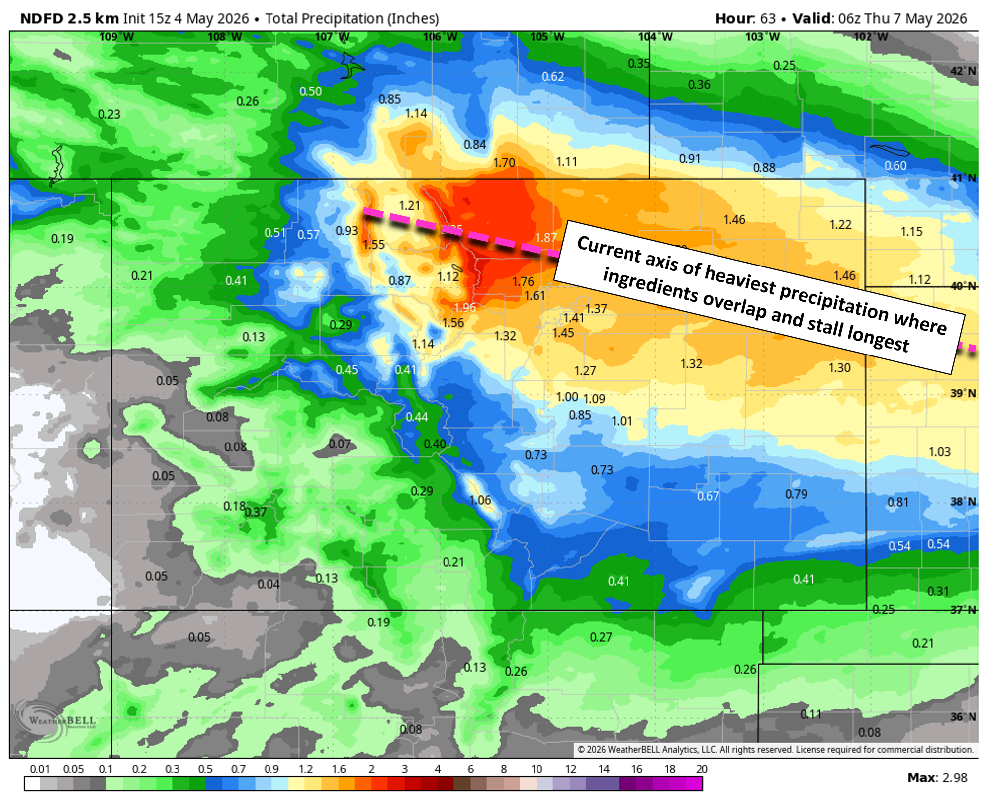
- Any shifts to the heaviest axis of precipitation: The best forcing with this system will align and stay squarely parked over the Front Range for 24 to 36 hours Tuesday into Wednesday, but there will be a bullseye area that gets hit hardest. This axis of heaviest precipitation is currently forecast to be over Boulder and/or Larimer Counties stretching eastward towards NW Kansas, but if this axis shifts north or south at all, we could see a big shift in the forecast precipitation and thus snowfall amounts.
- How the final third of the storm unfolds: Modeling is starting to latch onto a potentially more robust period of cold, deep and efficient upslope slamming the northern Front Range on Wednesday morning in response to a mid-level low in western Colorado. This is still somewhat uncertain, but this upslope could help keep more intense snowfall rates going through much of Wednesday morning (rather than just Tuesday night) with decent snow ratios everywhere (10-to-1 or better). This could ultimately end up boosting snowfall totals higher with bonus snow falling late in the game Wednesday morning.
If we see any need to update things, including our snowfall forecast map, timing or impacts, we’ll post another update here Tuesday morning so be sure to check back or stay subscribed.
Bottom Line
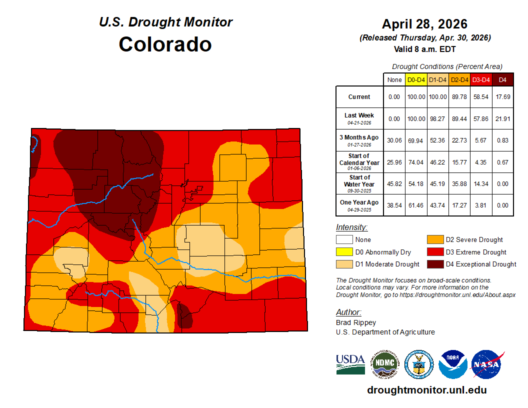
Despite how disruptive this storm may well be, it arrives against the backdrop of a deepening drought that has been steadily tightening its grip on the Front Range for six months or more. Boulder County is sitting with 100% Extreme Drought coverage, something we haven’t seen since 2012 — a year remembered for its relentless fire activity and rapid spring drying.
From a historical standpoint, this is the kind of late‑season storm that is common in Boulder’s climate history, at least in terms of raw precipitation output. May is our wettest month, and May snowfall is far from unusual here, but storms of this magnitude — with deep upslope, cold air, heavy wet snow, and widespread tree damage potential — fall into a more elite category, similar to recent impactful May snow events we had in 2019 and 2022. The combination of significant moisture, heavy snow, and a fully leafed‑out landscape weeks ahead of schedule makes this one stand out in terms of risk. Mother Nature is giving us a rare opportunity for drought relief, but unfortunately it comes gift-wrapped inside a high‑impact, damaging spring storm, one that will leave a mark on both our reservoirs and our trees.
Beyond the Snow
Once the snow exits and Thursday morning’s freeze passes, the pattern quiets down. A weak disturbance may bring a few showers Thursday evening and/or Friday, but temperatures will rebound into the lower 70s by Friday afternoon and our usual May weather will resume.
Spread the word, share our crazy Colorado weather:
Go Premium, get all the perks.
Daily Forecast Updates
Get our daily forecast discussion every morning delivered to your inbox.
All Our Model Data
Access to all our Colorado-centric high-resolution weather model graphics. Seriously — every one!
Ski & Hiking Forecasts
6-day forecasts for all the Colorado ski resorts, plus more than 120 hiking trails, including every 14er.
Smoke Forecasts
Wildfire smoke concentration predictions up to 72 hours into the future.
Exclusive Content
Weekend outlooks every Thursday, bonus storm updates, historical data and much more!
No Advertisements
Enjoy ad-free viewing on the entire site.


You must be logged in to post a comment.