A big change is about to hit Front Range: after one more warm, breezy Friday, a strong cold front sweeps in overnight, dropping temperatures to the coldest of the season. Will Denver and Boulder finally see their first snow? That’s not guaranteed, unfortunately, but the Mountains are in for several fluffy inches and tricky travel ahead. Read on for the full breakdown—including details on the timing, our snowfall map, travel impacts and what lies ahead for our next wintry system on Sunday.
What You Need to Know
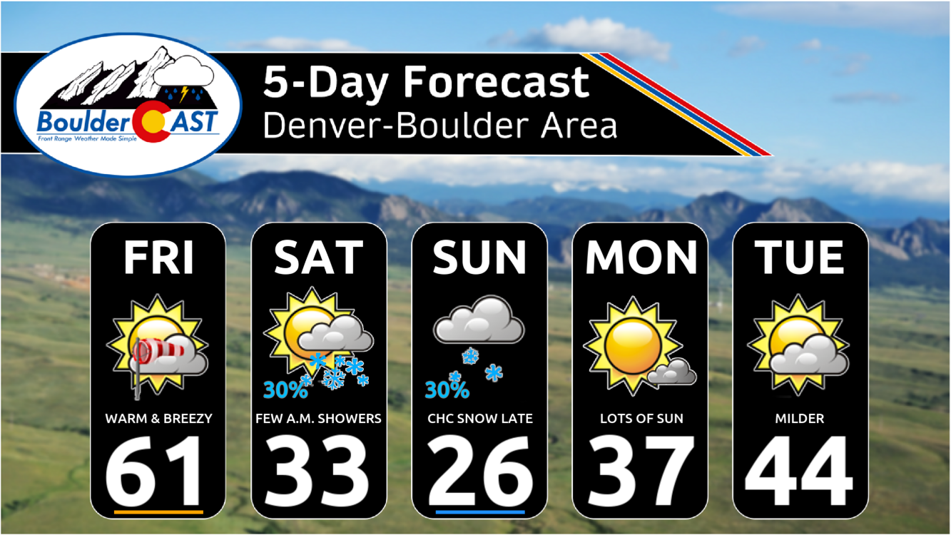
- Warm on Friday: Warm and dry again across the Front Range, with highs in the low–mid 60s and gusty downslope winds briefly elevating fire danger in the Foothills.
- Friday Night Front: A strong front sweeps through after midnight, dropping temperatures sharply; only a short window for rain changing to snow in Denver/Boulder, with little moisture available.
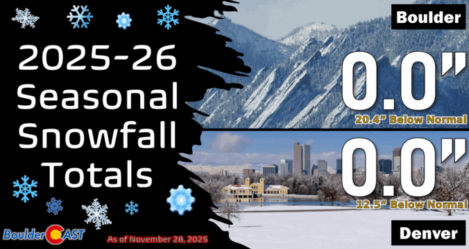
- Snow Impacts: Boulder/Denver area accumulation looks minimal (<1″), with many areas seeing just a dusting or none at all. Mountains fare much better with 3–7″ including possible snow squalls, creating hazardous travel on passes.
- Weekend Cold: Coldest air of the season settles in—Highs Saturday near freezing, Sunday below freezing. Lows in the teens, some spots in the single digits.
- Sunday: Round Two of Snow? Another weak system Sunday will bring moderate snow to the High Country (another 4-7″+) and a slight chance for flakes in the Metro area. Any accumulation would be light (<2″).

Go Premium, get all the perks.
Daily Forecast Updates
Get our daily forecast discussion every morning delivered to your inbox.
All Our Model Data
Access to all our Colorado-centric high-resolution weather model graphics. Seriously — every one!
Ski & Hiking Forecasts
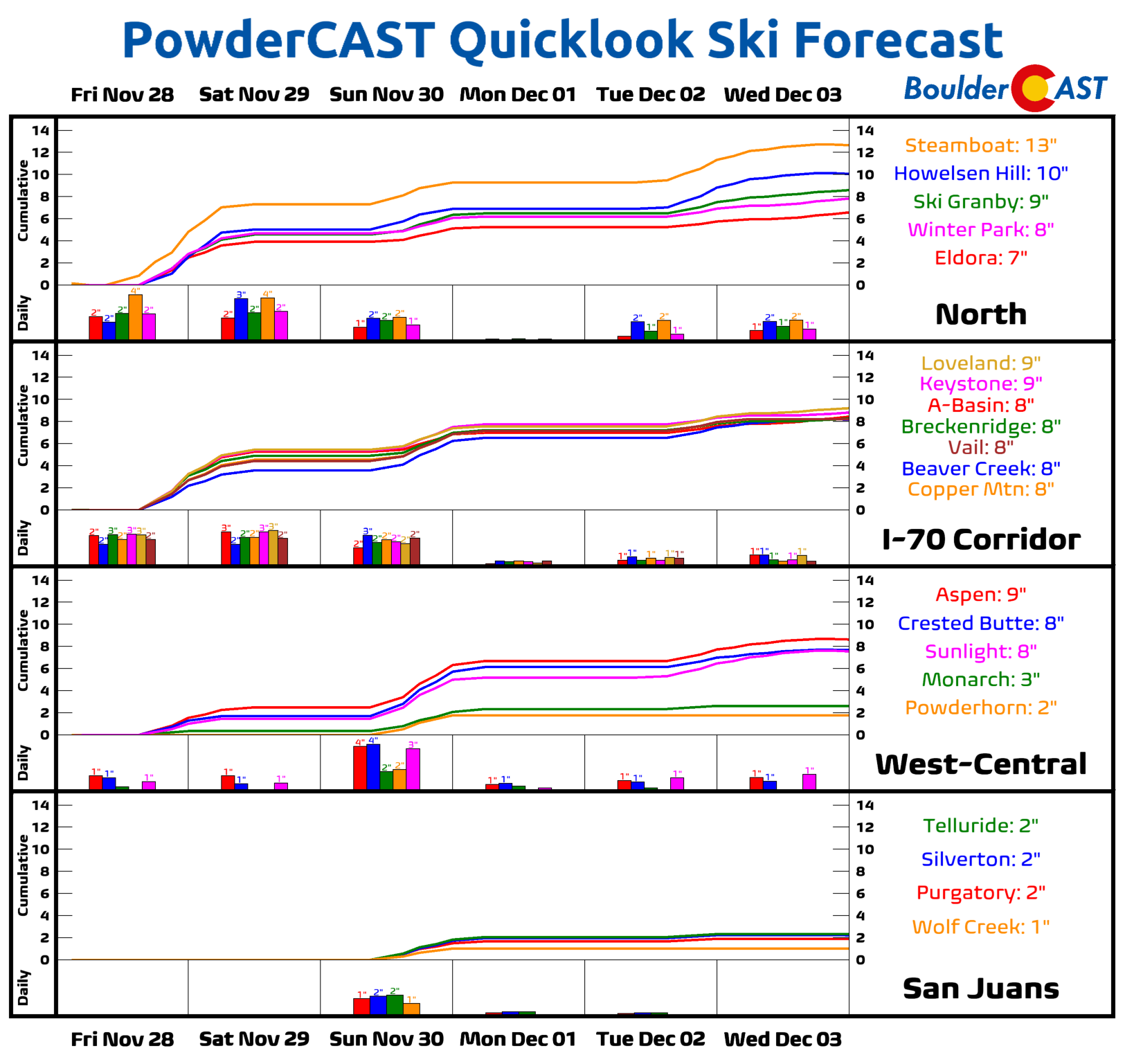
6-day forecasts for all the Colorado ski resorts, plus more than 120 hiking trails, including every 14er.
Smoke Forecasts
Wildfire smoke concentration predictions up to 72 hours into the future.
Exclusive Content
Weekend outlooks every Thursday, bonus storm updates, historical data and much more!
No Advertisements
Enjoy ad-free viewing on the entire site.
A warm Friday ahead of big changes
Change is brewing across Colorado, but before that happens, Friday will be business as usual in the Front Range with another warm and dry fall day. Like so many November days before it, highs will reach the lower to middle 60s this afternoon.
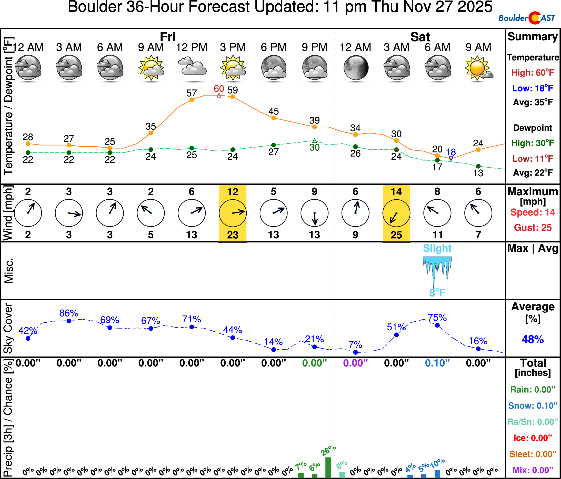
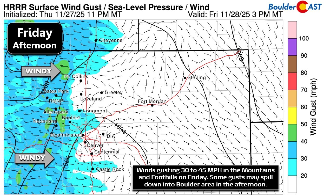
By afternoon, downslope winds from the west will kick up, briefly raising fire danger in the Foothills and wind-prone spots like south Boulder, Rocky Flats, the Broomfield Airport, and Arvada.
Strong cold front arrives Friday night, but will it snow?
A Canadian cold front remains on-track to move north to south across eastern Colorado Friday night, ushering in the coldest air of the season.
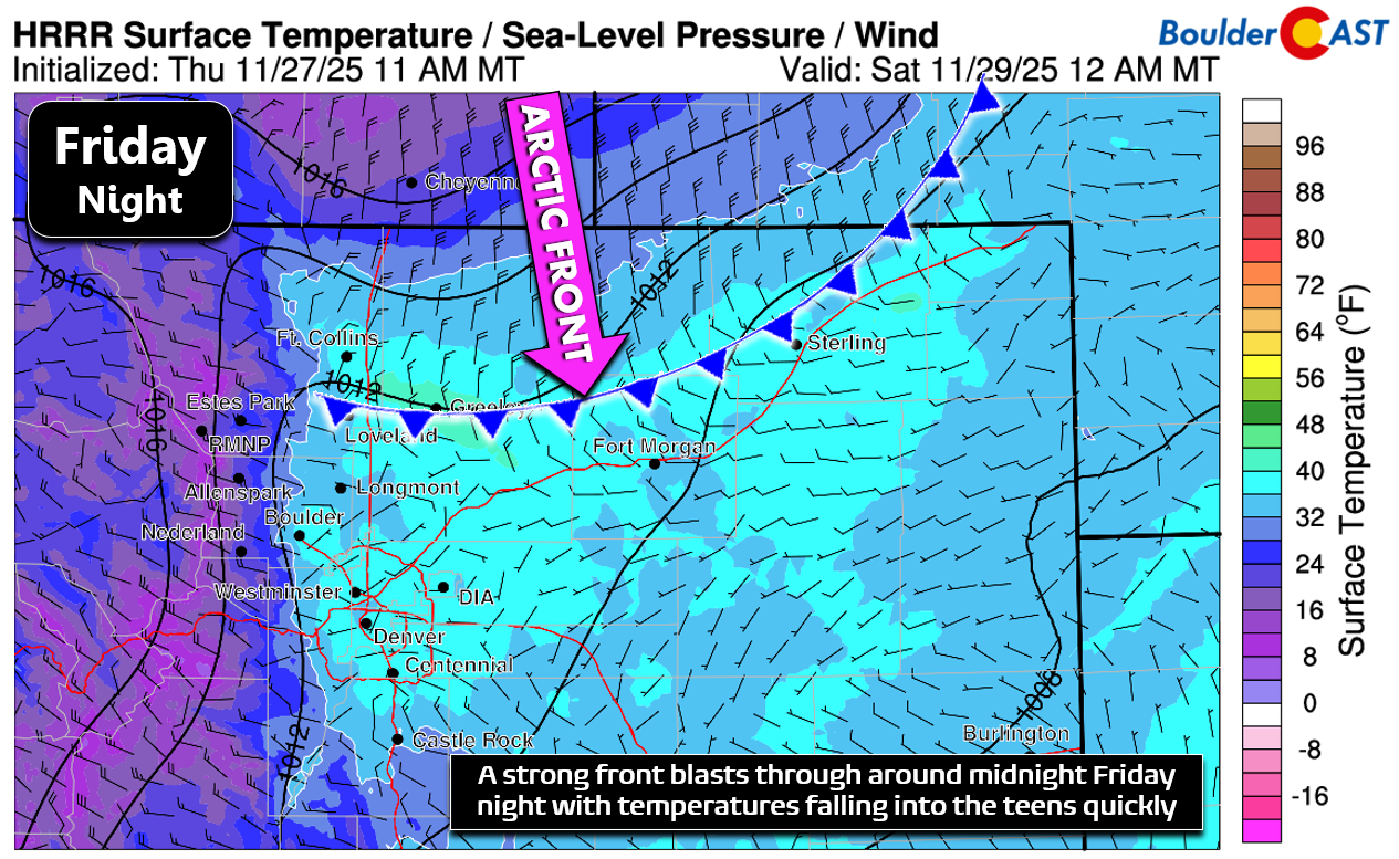
Latest model trends bring the front into the Denver area just after midnight, with spotty showers possible before (rain) and after (changing to snow). We’ve seen the forecast models shift over the last day or two, pushing the parent storm across the area a bit faster. The result will be only a brief window for snowflakes in the Metro area late tonight into Saturday morning, with the towering Mountains to our west absorbing most of the limited moisture. Everything blows past us so quickly that there’s not even enough time to generate much upslope east of the Mountains.
Flow at 700mb (~10,000 feet) will be brisk and from the northwest, leading to several inches of orographic snow in the Mountains (with some spill-over into the high Foothills):
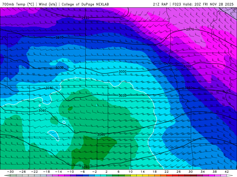
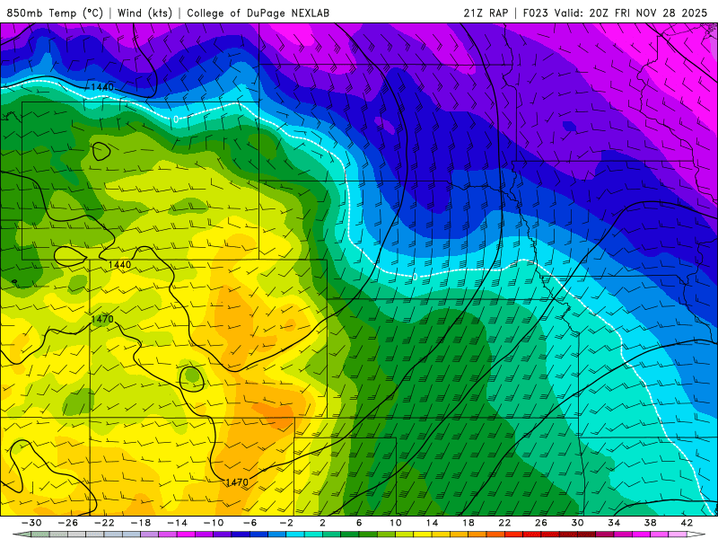
Low-level flow into Boulder and Denver will largely be northerly tonight, which may bias the already questionable snow chances in the Metro area towards the south side of Denver (downsloping off Cheyenne Ridge, slight upslope into Palmer Divide):
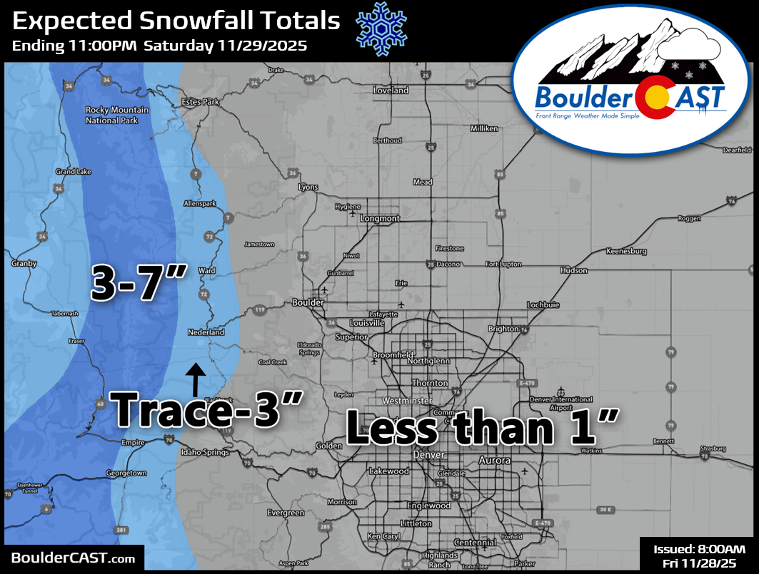
Bottom line: snow chances are questionable for the lower elevations, though we have some faith that this Arctic front will at least create a few snowflakes in most areas. Accumulations will be minimal—generally under 1 inch below 8,500 feet. Some cities may see little to no snow at all. Where flakes do occur, slick spots could develop by Saturday morning, but widespread travel impacts are unlikely outside the Mountains.
This storm will be much more impactful in the High Country:
- Mountain Snow Totals: 3–7 inches broadly, with localized higher amounts possible near Steamboat Springs.
- Hazards: Snow squalls are possible Friday night as the front barrels through. Roads will become slick and snow-packed.
- Timing: Expect deteriorating conditions on mountain passes beginning around sunset Friday, worsening overnight.
A Winter Weather Advisory is in effect from 5PM Friday through 8AM Saturday in the Mountains areas highlighted below:
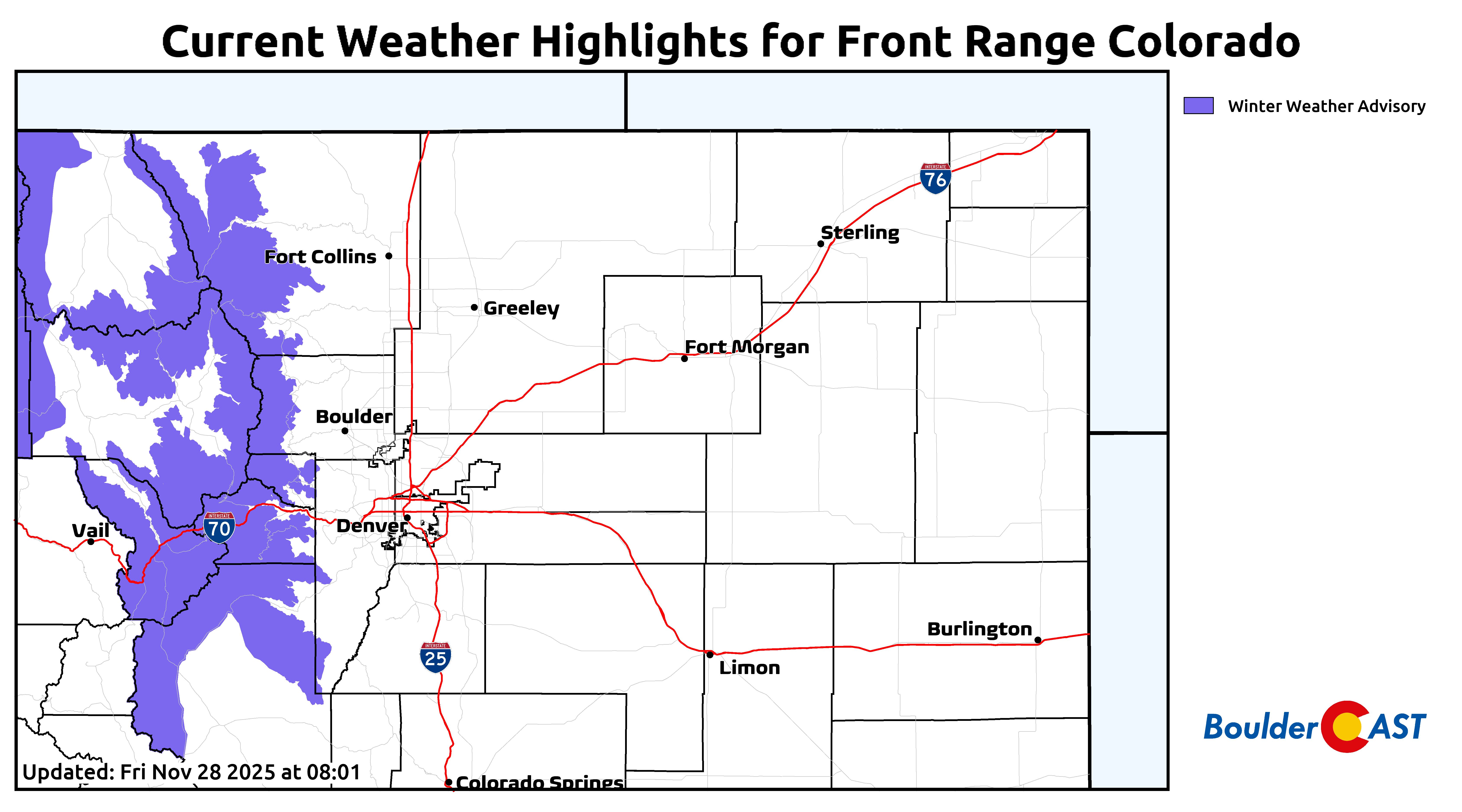
Our final snowfall forecast map covering snow Friday evening into Saturday morning is shown below.
Our next storm coming in Sunday afternoon will once again bring moderate snowfall to the High Country with more widespread, longer-lasting travel impacts expected up there Sunday afternoon through Sunday night.
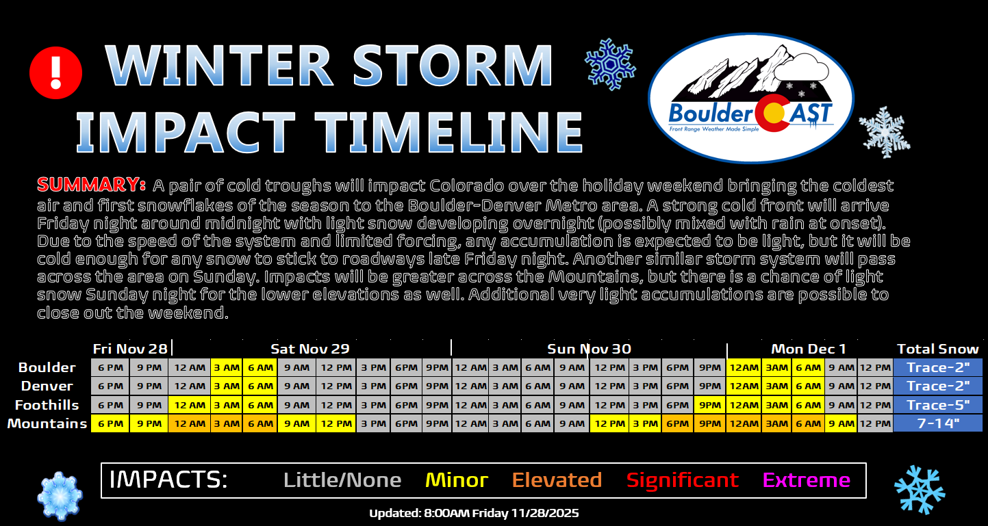
If Boulder and Denver miss out Friday night, Sunday night will offer a second chance at a first measurable snow—but again, totals look meager (nothing up to 2 inches).

The bigger story for the lower elevations will be the cold temperatures this weekend, by far the coldest we’ve seen yet in what has been a very warm autumn. Highs on Saturday will be near freezing, and by Sunday, below freezing. Overnight lows will be in the teens through Monday morning, perhaps even single digits if skies are able to clear out a bit. We’ll briefly moderate into the 30s and 40s early next week ahead of another cooldown (and light snow chance) brewing around the middle of the week.
Happy Black Friday!
Spread the word, share our crazy Colorado weather:
Go Premium, get all the perks.
Daily Forecast Updates
Get our daily forecast discussion every morning delivered to your inbox.
All Our Model Data
Access to all our Colorado-centric high-resolution weather model graphics. Seriously — every one!
Ski & Hiking Forecasts
6-day forecasts for all the Colorado ski resorts, plus more than 120 hiking trails, including every 14er.
Smoke Forecasts
Wildfire smoke concentration predictions up to 72 hours into the future.
Exclusive Content
Weekend outlooks every Thursday, bonus storm updates, historical data and much more!
No Advertisements
Enjoy ad-free viewing on the entire site.


You must be logged in to post a comment.