
After a weekend of thunder and cooler air, the Front Range is catching its breath under clear skies and a brief spell of dry northwest flow. But don’t get too comfortable—heat, haze, and a few storm chances are already lining up for a return later this week. In this update, we break down the shifting ridge pattern, what it means for temperatures, and when wildfire smoke and monsoon moisture might make a comeback.
This week’s highlights include:
- Trough exits east: Weekend storms and cooler temps are gone, leaving dry northwest flow and clear skies across the Front Range to start our week.
- Ridge builds in: A slow-moving high pressure ridge will dominate the week—less intense than last week’s heat dome but still hot and dry.
- Temps climb: Monday starts cooler (low 80s), but highs reach the 90s midweek, with a chance of record heat Wednesday or Thursday in Boulder.
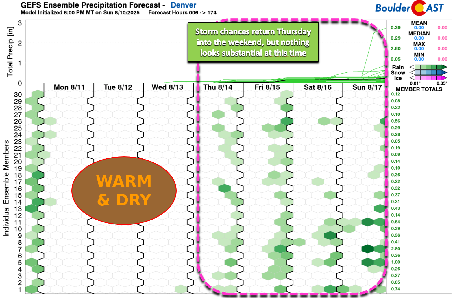
- Storm chances low: Warm air aloft, weak forcing, and dry conditions suppress storm development until late in the day Thursday.
- Moisture returns: Isolated storms possible Thursday (mainly in the Mountains), with broader storm chances Friday into the weekend.
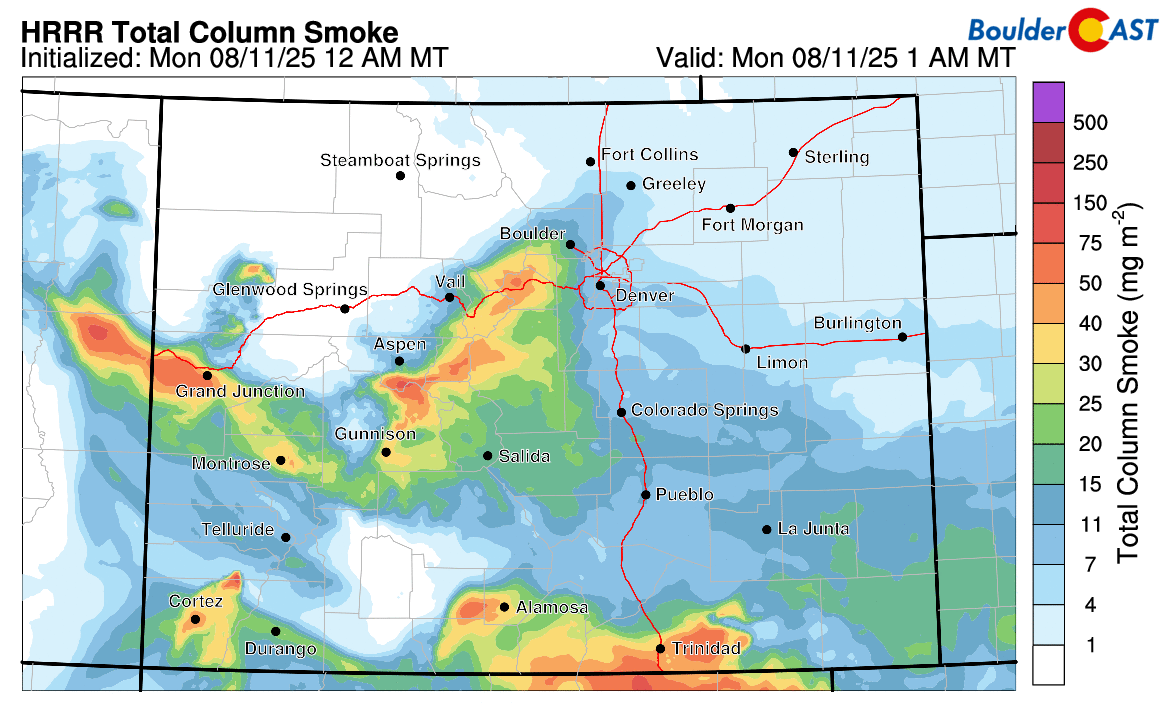
- Smoke outlook: Western Slope fires remain active; northwest winds keep smoke away early in the week, but it returns by Wednesday.
DISCLAIMER: This weekly outlook forecast is created Monday morning and covers the entire upcoming week. Accuracy will decrease as the week progresses as this post is NOT updated. To receive daily updated forecasts from our team, among many other perks, subscribe to BoulderCAST Premium.

Go Premium, get all the perks.
Daily Forecast Updates
Get our daily forecast discussion every morning delivered to your inbox.
All Our Model Data
Access to all our Colorado-centric high-resolution weather model graphics. Seriously — every one!
Ski & Hiking Forecasts
6-day forecasts for all the Colorado ski resorts, plus more than 120 hiking trails, including every 14er.
Smoke Forecasts
Wildfire smoke concentration predictions up to 72 hours into the future.
Exclusive Content
Weekend outlooks every Thursday, bonus storm updates, historical data and much more!
No Advertisements
Enjoy ad-free viewing on the entire site.
A Brief Break Before the Heat and Haze Return
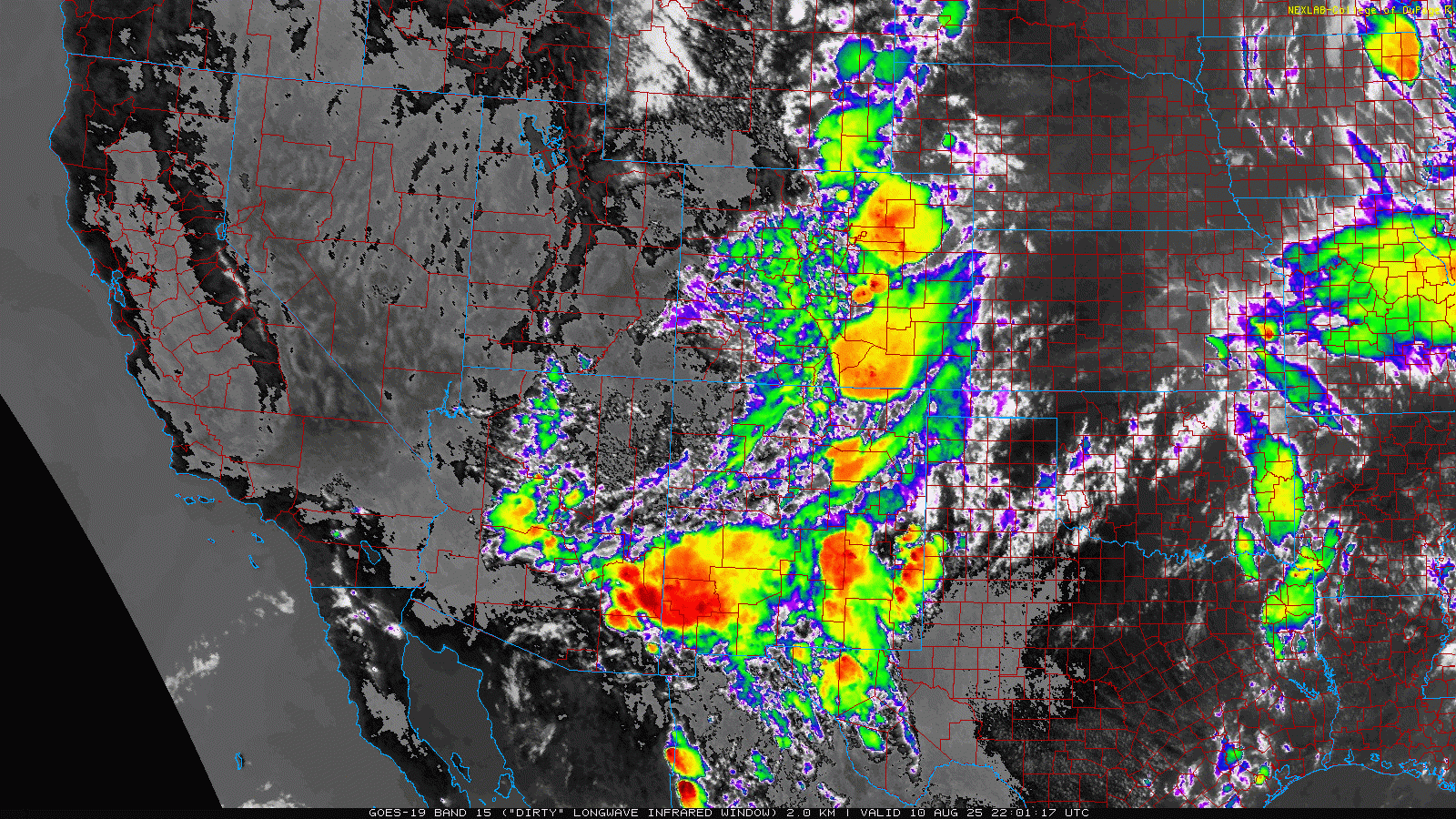
The trough that brought cooler temperatures and lively thunderstorms to the Front Range over the weekend has shifted off to our east as of Monday morning leaving behind dry northwest flow in its wake. All of the convection, including some nocturnal severe storms, have vacated Colorado with mostly clear skies noted across our area early this morning:
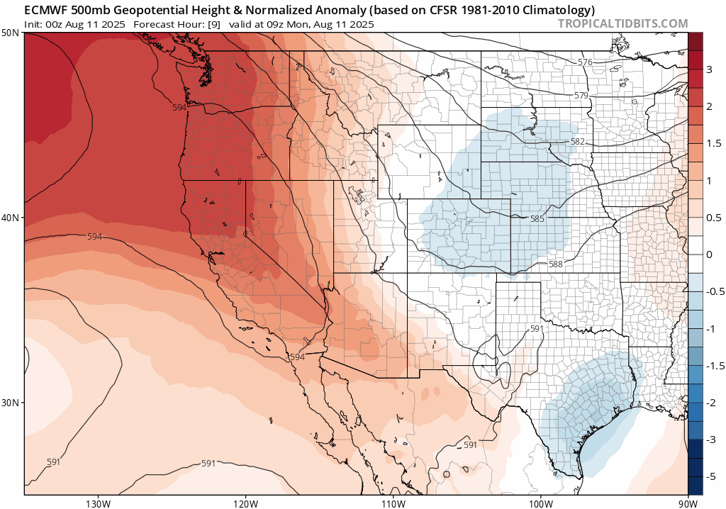
That departing trough will continue to weaken and drift east through Monday. Meanwhile, a slow-moving ridge of high pressure will begin sliding across Colorado. It’s not going to be the intense heat dome we dealt with last week, but it’ll still bring several hot and mostly dry days as it settles in.
Here’s how the Euro model’s 500mb height anomaly forecast plays out through Friday night:
- Monday & Tuesday: The ridge is centered over California, placing us downstream in cooler, dry northwest flow.
- Wednesday & Thursday: The ridge shifts over Arizona and New Mexico, putting the Front Range directly under its influence—storm chances will be minimal as the heat ramps up.
- Friday into Weekend: The ridge moves into the central U.S., allowing southwest flow to return to Colorado with temperatures staying hot and moisture returning.
Storm Chances: Slim Early, Better Late
Most of this week won’t be favorable for storm development. We’re looking at warm air aloft, weak forcing, and limited moisture—classic ingredients for a quiet stretch. While monsoon season isn’t over, this week’s air mass is drier than usual for mid-August.
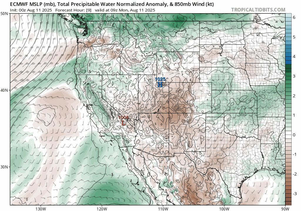
By late Thursday, we’ll see a modest uptick in moisture, enough to support isolated storms—mainly over the Mountains, but possibly spilling into lower elevations. Friday brings broader storm chances across the region, with at least low-end coverage expected into the weekend. Nothing looks particularly wet in the extended outlook, but we’ll keep an eye on how things evolve by week’s end.
Temperatures Trend Up
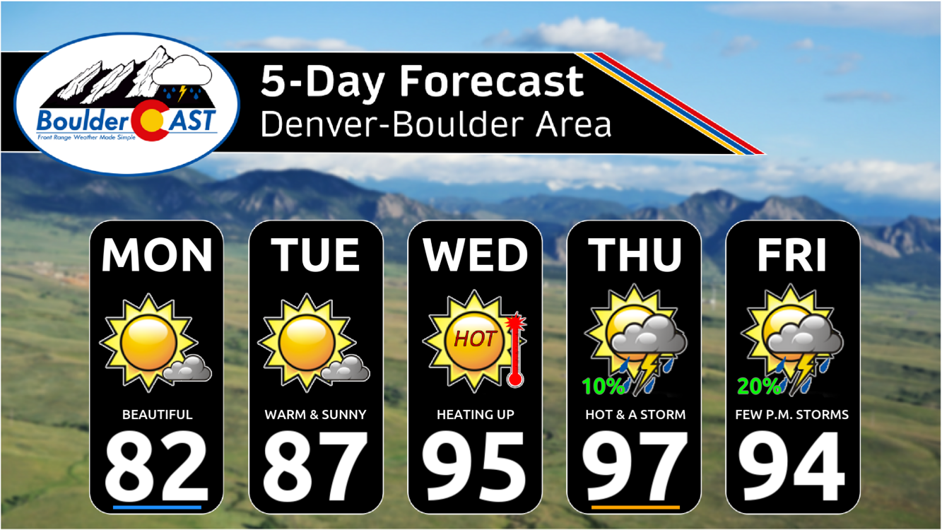
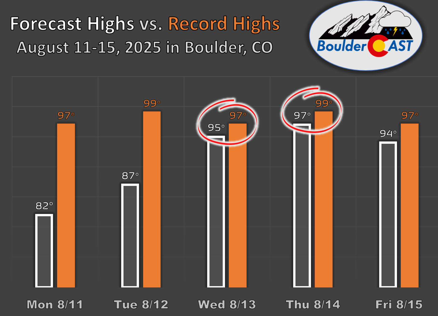
As far as temperatures, we’ll start the week with a single day cooler than normal on Monday with highs in the lower 80s, while Tuesday will warm into the mid to upper 80s. Wednesday through Friday will see temperatures well into the 90s.
In fact, we will be flirting with record heat later in the week with new daily record highs possible (but not likely) Wednesday or Thursday in Boulder.
Wildfire Update & Smoke Outlook
Large fires continue to burn across the Western Slope, with containment still under 10% for the biggest fires. The map below shows the location of the fires in the state relative to the Denver Metro area.
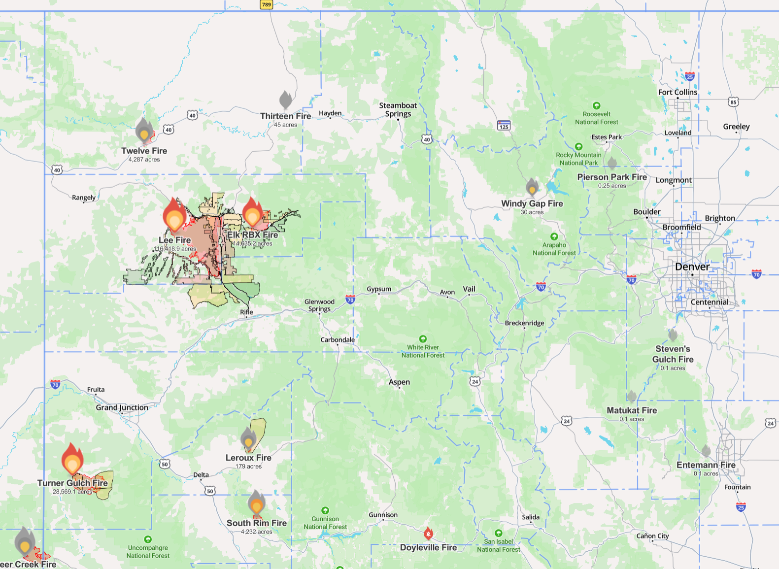
Source: WatchDuty
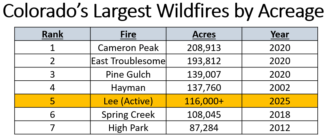
The largest active blaze, the Lee Fire, has grown to over 116,000 acres making it the 5th largest fire in state history, with further jumps up the list not out of the question. Last week was ripe for fire growth. It will be better this week with less wind, hopefully allowing firefighters a chance to increase containment. Late-week rain and humidity increases should also help.
Northwest winds early this week will help keep smoke away from the Front Range, pushing it toward southwest Colorado through Tuesday. But by Wednesday, the wind direction shifts again, and smoke will likely drift back into our area.
So enjoy the brief reprieve: cooler temps, sunshine, and cleaner air to start the week. The heat, haze, and storm chances will be back soon enough.
Forecast Specifics:
Monday: Lots of sun with just a few late-day clouds. Highs very comfortable in the lower 80s across the Plains with lower 70s in the Foothills.
Tuesday: Mostly sunny and warmer with highs reaching the mid to upper 80s on the Plains and middle 70s in the Foothills.
Wednesday: A mix of clouds and sun and hotter. Highs soar into the middle 90s on the Plains with lower 80s in the Foothills.
Thursday: Morning sun, then partly cloudy and hot. There’ll be a slight chance of a late-day storm, mainly in the higher terrain. Highs reach the mid to upper 90s on the Plains with middle 80s in the Foothills.
Friday: Staying hot with a chance of late-day storms. Highs a tad cooler in the low to middle 90s across the Plains with lower 80s in the Foothills.
Weekend: Highs stay warm in the lower 90s with low-end chances for late-day storms both days.
DISCLAIMER: This weekly outlook forecast is created Monday morning and covers the entire upcoming week. Accuracy will decrease as the week progresses as this post is NOT updated. To receive daily updated forecasts from our team, among many other perks, subscribe to BoulderCAST Premium.
Go Premium, get all the perks.
Daily Forecast Updates
Get our daily forecast discussion every morning delivered to your inbox.
All Our Model Data
Access to all our Colorado-centric high-resolution weather model graphics. Seriously — every one!
Ski & Hiking Forecasts
6-day forecasts for all the Colorado ski resorts, plus more than 120 hiking trails, including every 14er.
Smoke Forecasts
Wildfire smoke concentration predictions up to 72 hours into the future.
Exclusive Content
Weekend outlooks every Thursday, bonus storm updates, historical data and much more!
No Advertisements
Enjoy ad-free viewing on the entire site.
Enjoy our content? Give it a share!


You must be logged in to post a comment.