Monsoon season may have officially started earlier this month, but it’s off to a sluggish and lack-luster beginning across Colorado. Boulder has seen frequent storms—yet little meaningful rain—and wildfire smoke from the Western Slope and neighboring states is starting to pool to our west. A cold front arriving Tuesday night will bring cooler temps and a bump in thunderstorm chances for Wednesday, followed by a promising shift toward a more classic monsoonal setup Thursday through the weekend ahead with continued daily storms. This week, we’re tracking some heat, smoky haze, and hopefully, a few solid soakings of rain.
This week’s highlights include:
- Slow monsoon kickoff: Boulder and much of Colorado have seen below-average rainfall, with many storms producing more wind than water. Boulder’s 30-day total sits at just 35% of normal.
- Storm variability: Despite sparse totals, Boulder did see measurable rain on 10 of the past 30 days. A strong hail-producing storm hit Gunbarrel last Friday, highlighting the hyper-local nature of monsoonal precipitation.
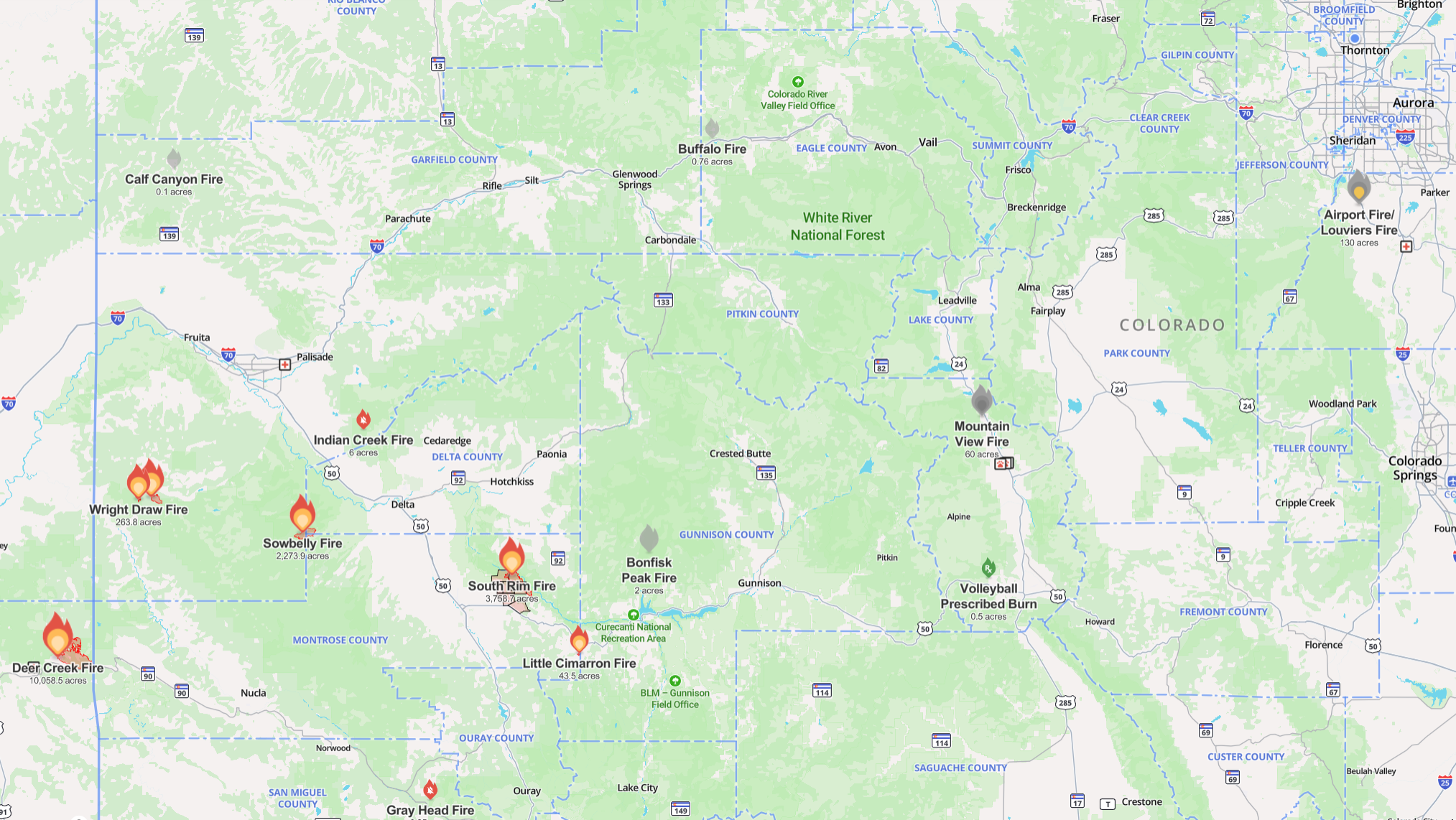
- Western wildfires: Lightning from dry storms sparked multiple fires on the Western Slope last, including the South Rim Fire, which is currently torching parts of Black Canyon of the Gunnison National Park.
- Smoke + ozone = poor air: Smoke from regional wildfires is expected to reach the Front Range by Wednesday, compounding the already bad ozone conditions and worsening air quality.
- Rain chances this week: Daily thunderstorm chances continue, with slightly higher odds by midweek thanks to a cold front and upslope flow—though rain still won’t be guaranteed. Wednesday will also carry a risk of severe weather.
- Monsoon recharge later in the week: A more classic monsoonal pattern arrives by Thursday through the weekend, pulling deep subtropical moisture into Colorado and improving storm coverage. Temperatures will stay near normal through the extended period.
DISCLAIMER: This weekly outlook forecast is created Monday morning and covers the entire upcoming week. Accuracy will decrease as the week progresses as this post is NOT updated. To receive daily updated forecasts from our team, among many other perks, subscribe to BoulderCAST Premium.

Go Premium, get all the perks.
Daily Forecast Updates
Get our daily forecast discussion every morning delivered to your inbox.
All Our Model Data
Access to all our Colorado-centric high-resolution weather model graphics. Seriously — every one!
Ski & Hiking Forecasts
6-day forecasts for all the Colorado ski resorts, plus more than 120 hiking trails, including every 14er.
Smoke Forecasts
Wildfire smoke concentration predictions up to 72 hours into the future.
Exclusive Content
Weekend outlooks every Thursday, bonus storm updates, historical data and much more!
No Advertisements
Enjoy ad-free viewing on the entire site.
A tepid start to monsoon season in the Front Range
It’s been ten days since we officially kicked off monsoon season in Colorado. Moisture began trickling into the Southwest, and scattered storms started popping across the Front Range—but overall, it’s been underwhelming. Most days have brought gusty winds without much actual rain, and the Denver Metro area is running below average for precipitation. South of I-70, it’s been especially dry.

Western Colorado hasn’t fared any better. Rainfall there has been significantly below normal, and the drought footprint continues to widen.
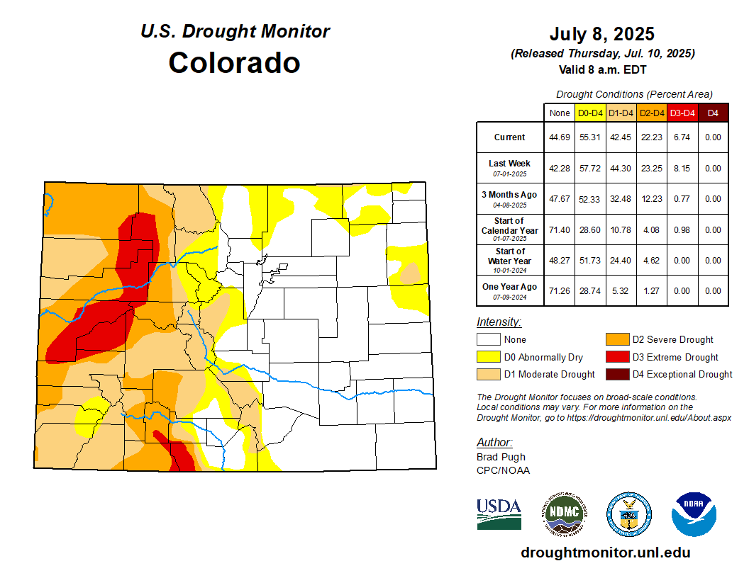
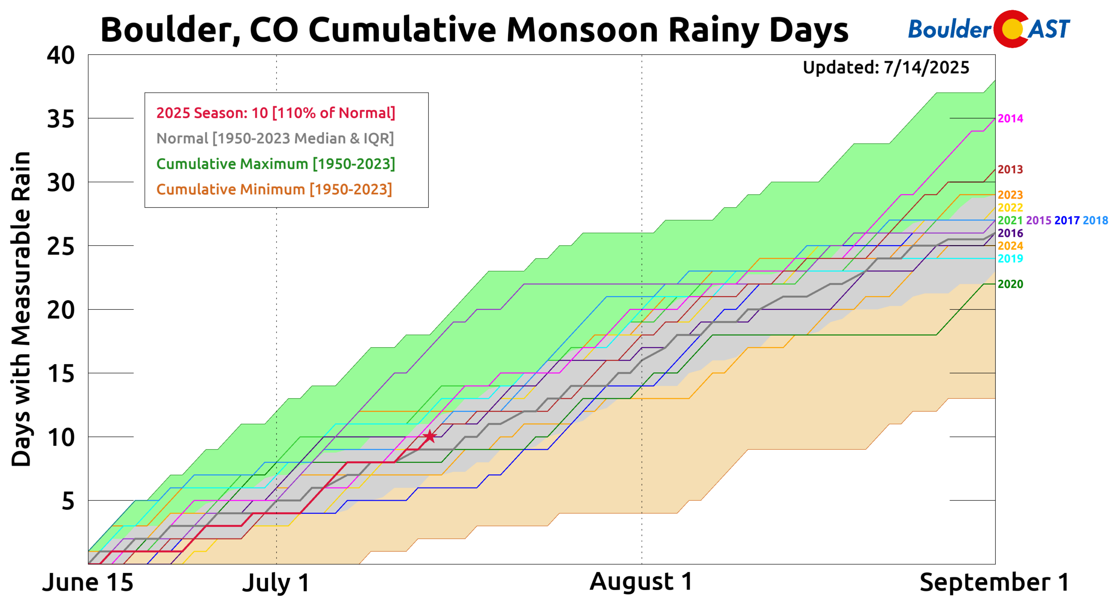
Boulder has seen just 0.55″ of rain over the last 30 days, a sheepish 35% of average, putting this stretch in the driest quartile of our climatology since 1950.

That said, we have seen rainfall on 10 out of the last 30 days—slightly above average. So the storms are showing up, but they’re not delivering the goods.
One notable exception came last Friday when a powerful thunderstorm dropped accumulating hail in Gunbarrel, damaging plants and trees.
The storm skirted north of Boulder through Gunbarrel and headed east toward Lafayette, dumping over an inch of rain in spots—but the city itself only picked up 0.20 inches (in south Boulder). A perfect example of just how fickle the monsoon can be.
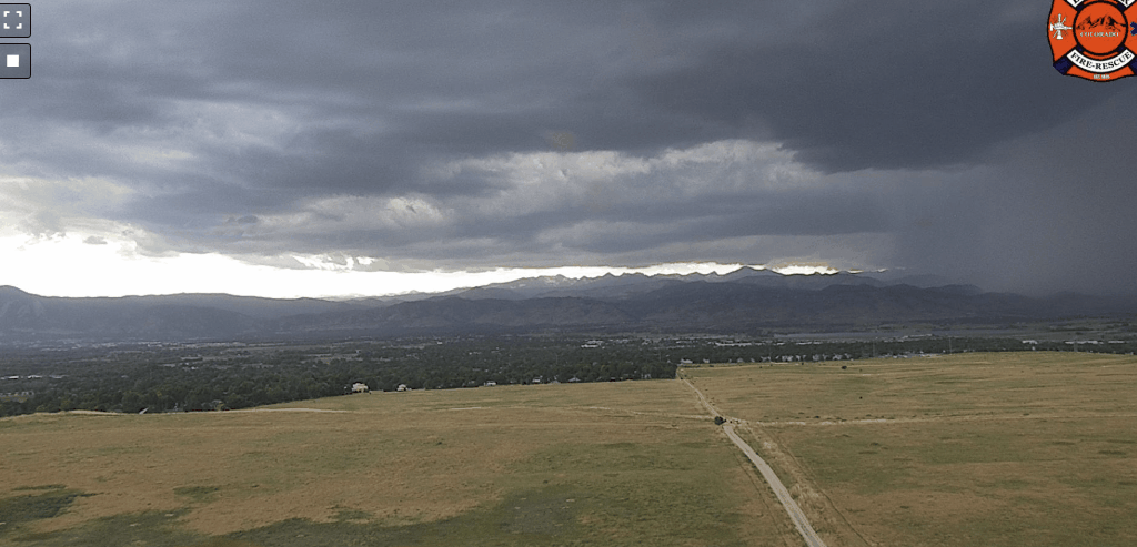
Timelapse of severe hailstorm hitting Gunbarrel on Friday July 11th in the evening
A tragic start to monsoon season on the Western Slope
On the other side of the state moisture has been scarce, lightning hasn’t—and that’s sparked several wildfires across the Western Slope. The most noteworthy so far is the South Rim Fire, which has burned over 3,700 acres including a large swath of Black Canyon of the Gunnison National Park in southwest Colorado. Hopefully you were able to make it down there in recent years — the most tourist-friendly and easily-accessible portion of the park will take decades to recover from this torching.
Smoke from these fires (and others in Utah, Nevada, and Arizona) is forecast to reach the Front Range by late Tuesday into Wednesday, compounding our already poor air quality.
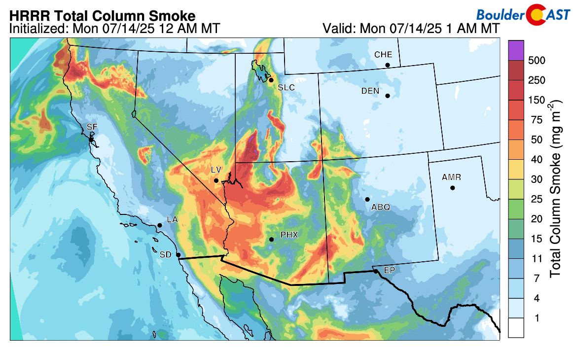
Total smoke forecast through Tuesday night. The worst of the smoke is slated to arrived into our area Tuesday night and early Wednesday.
Ozone levels have been rough lately, and incoming smoke will only make things worse come midweek.
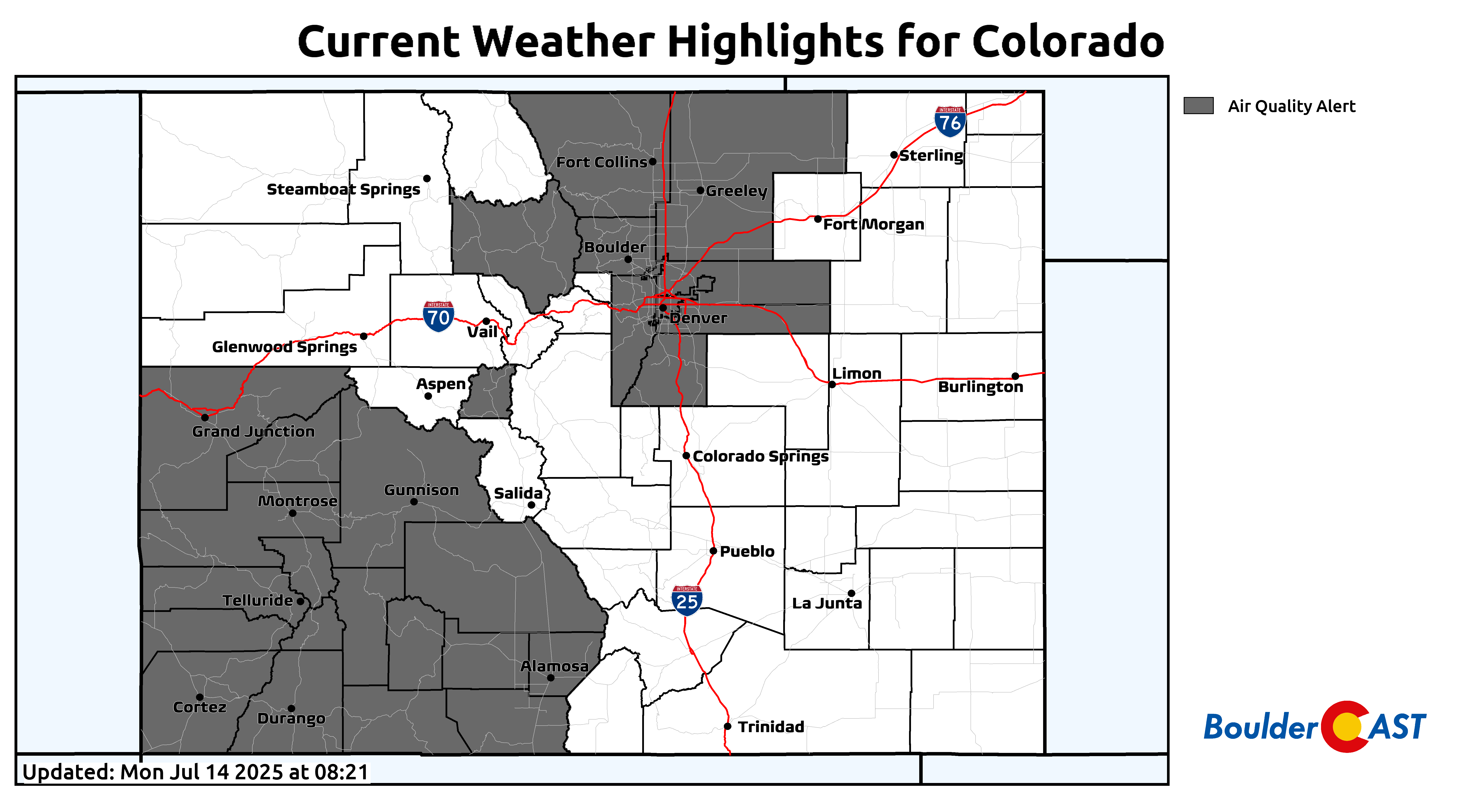
Air Quality is poor across the state on Monday due to ozone (Front Range) and smoke (Western Slope)
Looking ahead: Will the monsoon finally deliver this week?
A quick look at the ensemble precipitation forecast for the week ahead shows that there will be daily chances for thunderstorms in Boulder throughout the next seven days, though none of them look particularly soaking or have 100% guaranteed rainfall.
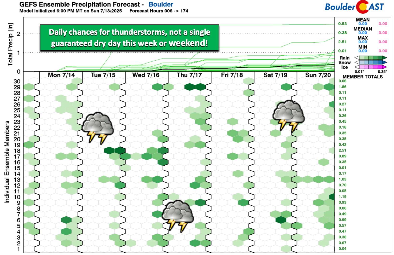
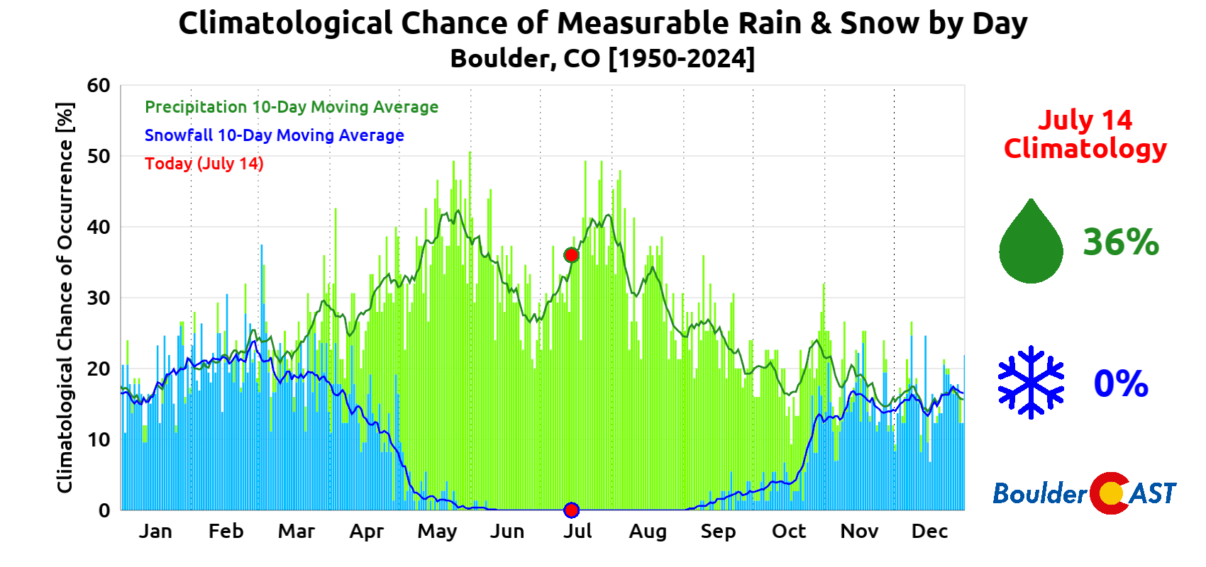
Boulder’s typical daily rain odds for mid-July hover around 36%, climbing to 42% by month’s end—so this week’s pattern aligns well with climatology.
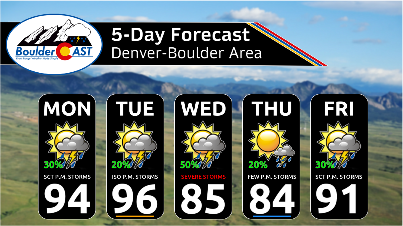
The early part of the week will see a weak high pressure center over the Four Corners point, with clockwise flow around this high pressure producing warm west-northwest flow aloft into our area alongside limited moisture availability. Under this setup, Monday and Tuesday will feature hot temperatures and only low-end chances for storms in the Front Range. Things will pick-up around midweek, initially resulting from a disturbance along the Canadian Border bringing a cold front through. More on that later.
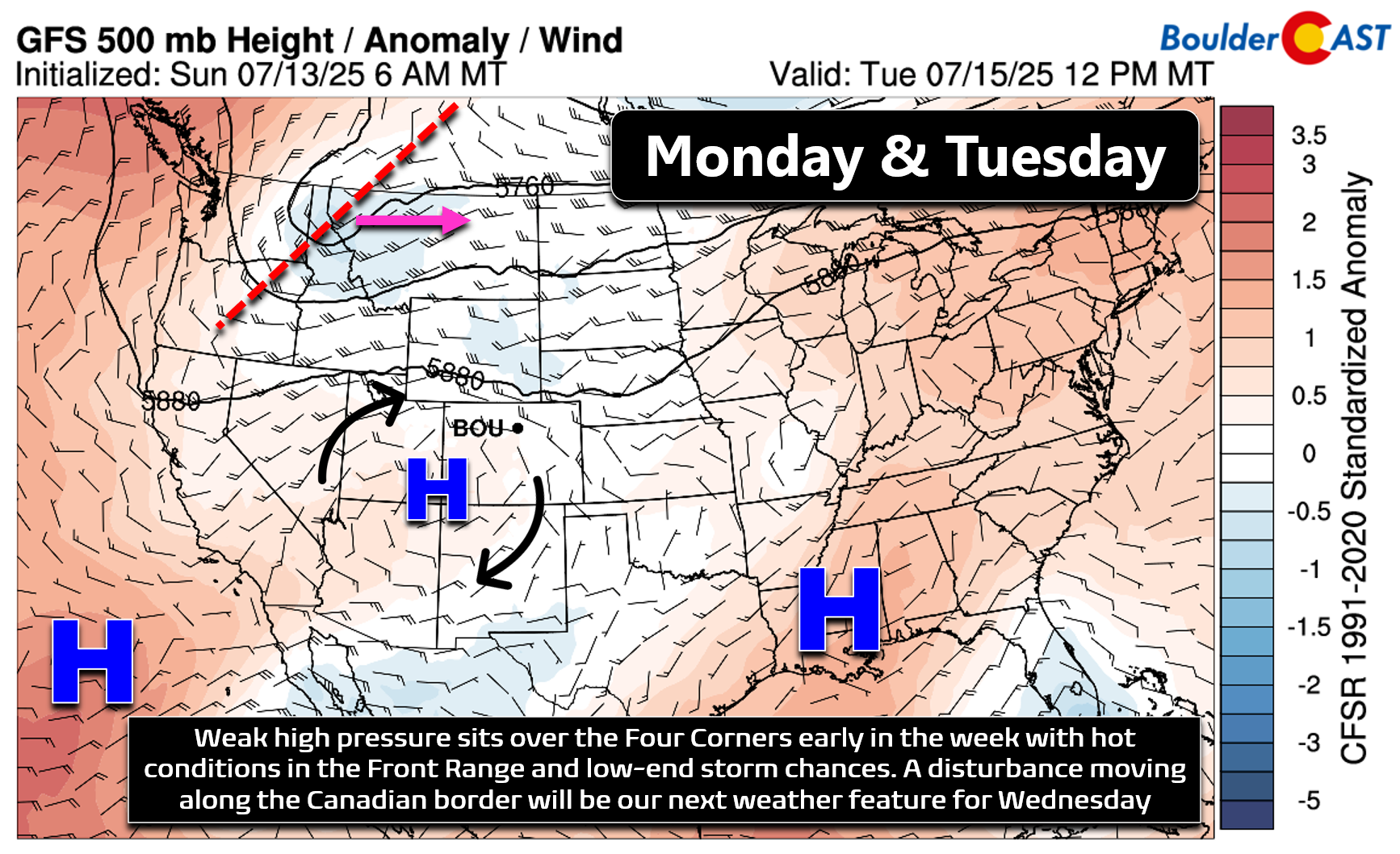
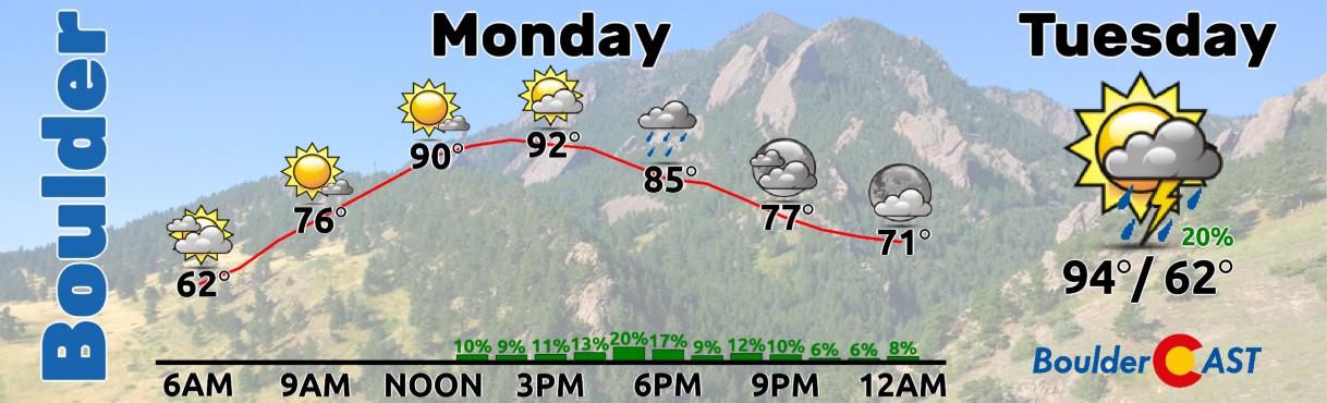
Monday will have a high temperature in the low to middle 90s with 20 to 30% chances for afternoon/evening storms — about as typical of a mid-July day as you can get here. Tuesday will be a couple degrees hotter but with lower rainfall chances, perhaps 10 to 20%.
As we head into midweek, that disturbance along the Canadian Border will start to bear some fruit for eastern Colorado in the form of a cold front and added moisture. The front is currently shaping up to move across our area late in the day Tuesday or Tuesday night. By Wednesday morning, the frontal boundary will be stalled out across southeast Colorado, with moisture-rich upslope flowing into the Boulder-Denver area from the northeast.

The animation below is the Euro model’s precipitable water (total column moisture) anomaly forecast for Tuesday into Wednesday night. This shows the transition from a rather dry early week here towards a wetter Wednesday as the parent shortwave passes by to our north and northeast. The surge in moisture we are expecting for Wednesday is clearly coming from the north and is not monsoonal in nature.
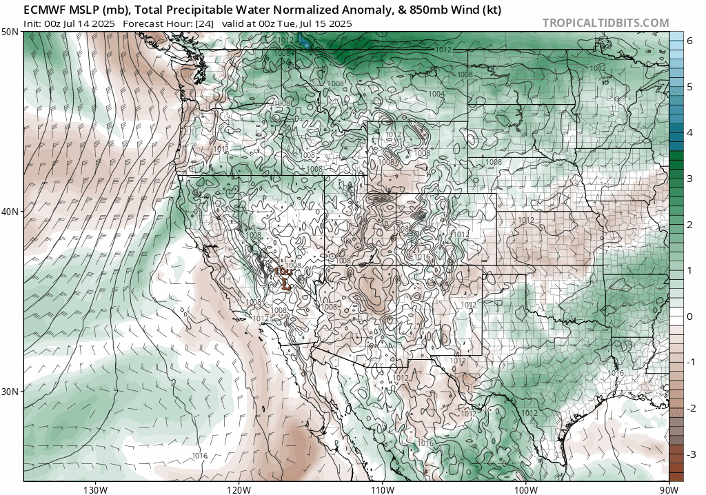
ECMWF precipitable water anomaly forecast for Tuesday into Wednesday night showing the moisture influx from the north behind a cold front
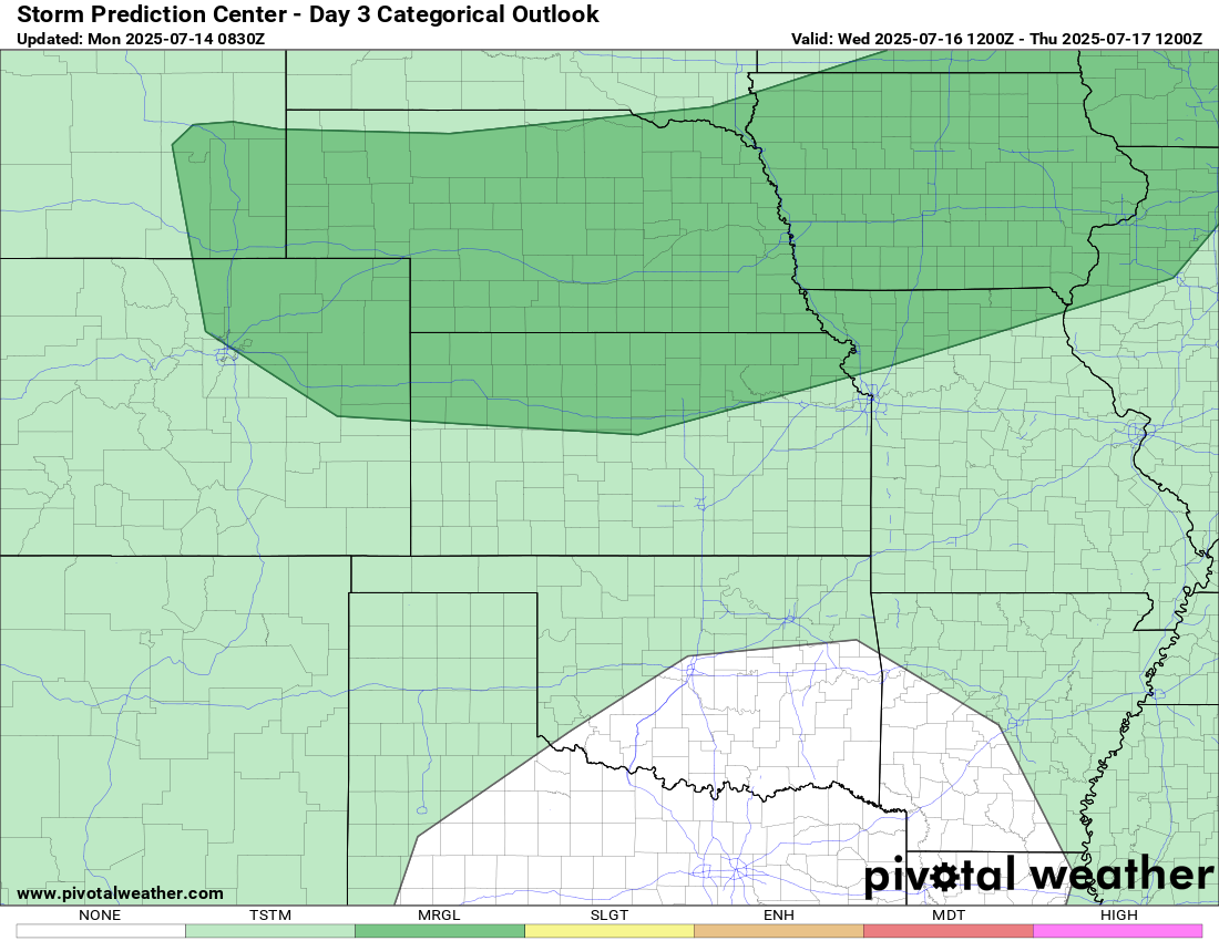
Nonetheless, this front will mean a cooler Wednesday for us with highs in the 80s, as well as better chances for late-day thunderstorms. It’s still a few days out, but this front will bring the ingredients together for at least a chance of severe storms across eastern Colorado on Wednesday. The Storm Prediction Center has Boulder and Denver at Marginal Risk already. We’ll have to wait until we get closer to fine-tine that aspect of the forecast, as there’s always a chance we end up too cool or too cloudy behind these type of summer fronts for severe weather.
Towards the end of the week into the weekend, the monsoon will begin to flex. A classic setup emerges with low pressure near SoCal and high pressure over the Southeast U.S., creating a deep south-to-north moisture pipeline into the Four Corners.
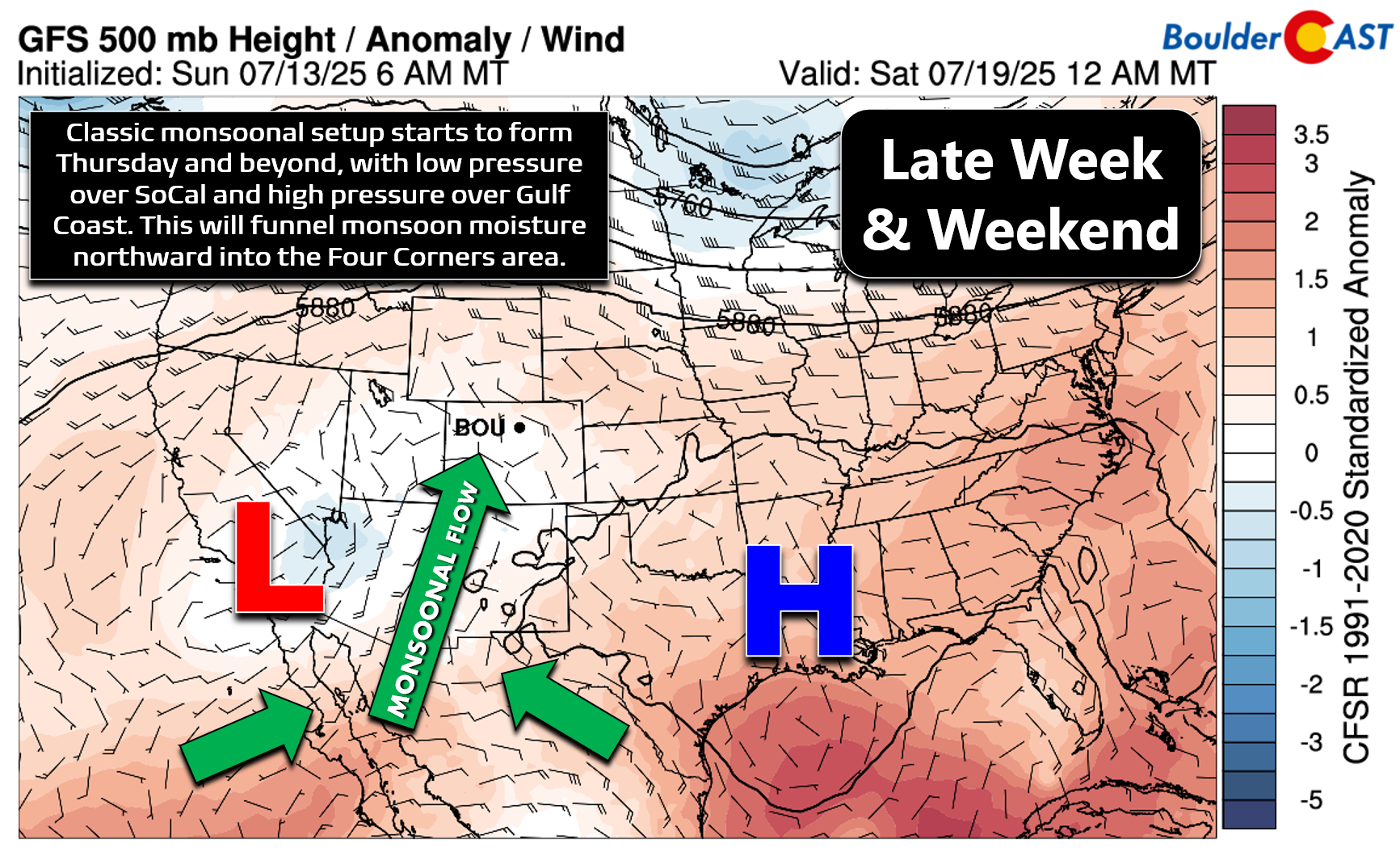
The Euro’s moisture anomaly forecast for Thursday through Sunday looks promising indeed, with several days in a row of deep monsoonal juice coming up from the south into our area.
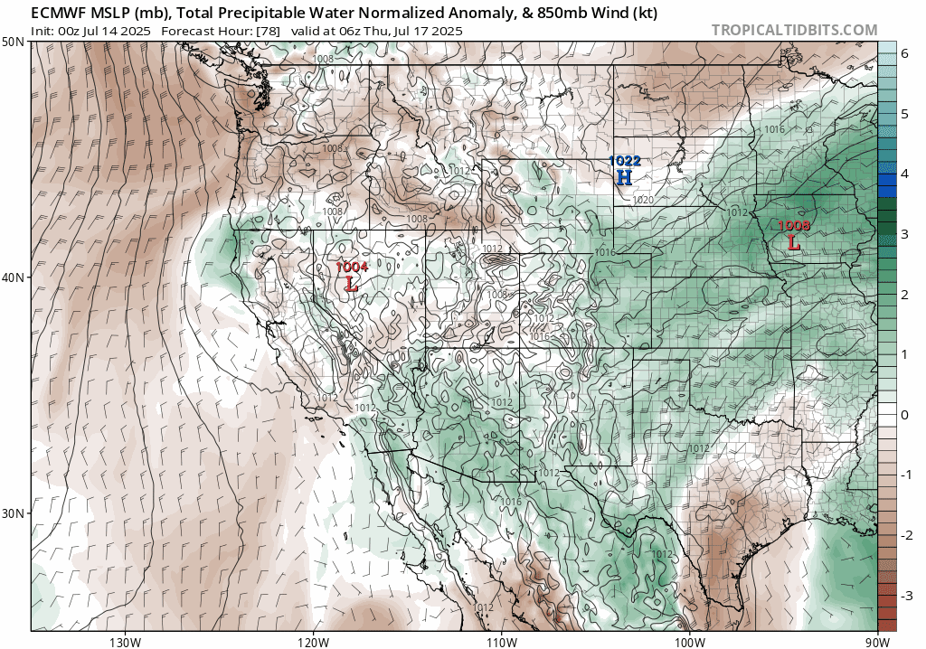
ECMWF precipitable water anomaly forecast for Thursday into the weekend showing the expected monsoonal surge from the south
Moisture will begin to build in on Thursday with isolated to widely scattered storms possible. The coverage should be slightly better on Friday, with a further increase in storms heading into Saturday and Sunday. The late-week period will also feature a warming trend with highs pushing back into the lower 90s by Friday and staying in that ballpark through the weekend ahead.
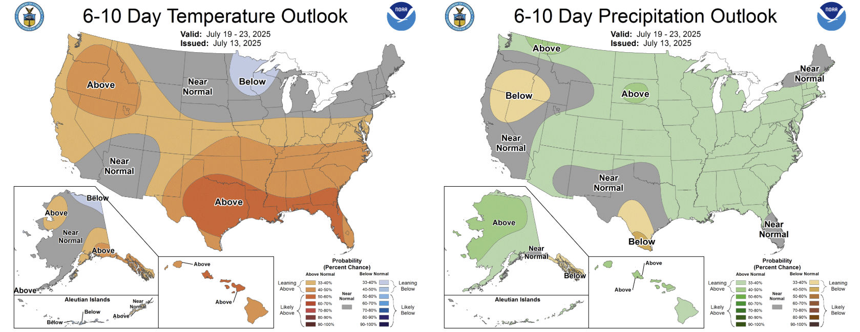
Monsoon moisture should stick around in some form into early next week. The CPC outlook for this weekend into early next week does have all of Colorado with increased chances for above normal precipitation, but doesn’t look to be the deluge our state desperately needs.
Forecast Specifics:
Monday: Partly cloudy with scattered late-day storms coming off the terrain. Highs in the low to middle 90s for the Plains with lower 80s in the Foothills.
Tuesday: Hot with isolated afternoon and evening storms. Highs in the middle to upper 90s on the Plains with lower 80s in the Foothills.
Wednesday: Cooler behind a cold front with possibly more cloud cover. Smoke from fires to our southwest may increase considerably. Storm coverage will be greater across the area (numerous to widespread) with some storms turning severe across eastern Colorado. Big hail and damaging winds will be possible. Highs in the middle 80s across the Plains with 70s in the Foothills.
Thursday: Staying cooler in the middle 80s with widely scattered late-day storms. The Foothills stay in the 70s.
Friday: Starting to heat back up. Morning sun gives way to scattered late-day storms. Highs return to the lower 90s on the Plains with upper 70s in the Foothills.
Weekend: Temperatures stay seasonal around 90 (+/- 5 degrees) with scattered to numerous late-day storms as monsoon moisture remains parked over the Front Range.
DISCLAIMER: This weekly outlook forecast is created Monday morning and covers the entire upcoming week. Accuracy will decrease as the week progresses as this post is NOT updated. To receive daily updated forecasts from our team, among many other perks, subscribe to BoulderCAST Premium.
Go Premium, get all the perks.
Daily Forecast Updates
Get our daily forecast discussion every morning delivered to your inbox.
All Our Model Data
Access to all our Colorado-centric high-resolution weather model graphics. Seriously — every one!
Ski & Hiking Forecasts
6-day forecasts for all the Colorado ski resorts, plus more than 120 hiking trails, including every 14er.
Smoke Forecasts
Wildfire smoke concentration predictions up to 72 hours into the future.
Exclusive Content
Weekend outlooks every Thursday, bonus storm updates, historical data and much more!
No Advertisements
Enjoy ad-free viewing on the entire site.
Enjoy our content? Give it a share!


You must be logged in to post a comment.