
Colorado’s scorcher of a weekend is finally giving way to cooler, stormier skies—and not a moment too soon. After record-breaking highs in Boulder and Denver, a refreshing cold front kicks off the week with below-normal temps and a solid chance for showers and storms, especially Tuesday when things could turn severe. But don’t get too cozy—the heat will make a comeback late in the week into the weekend. Here’s what you need to know about Colorado’s weather during this final week of June.
This week’s highlights include:
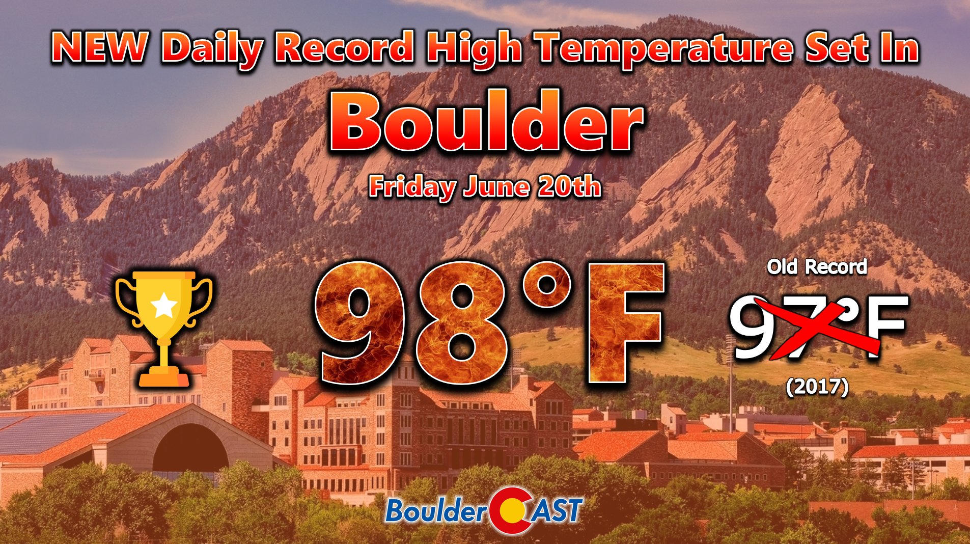
- Heatwave recap: Last week’s heatwave peaked Friday with record highs in Boulder (98°F) and Denver (99°F), with Saturday and Sunday landing cooler but still hot.
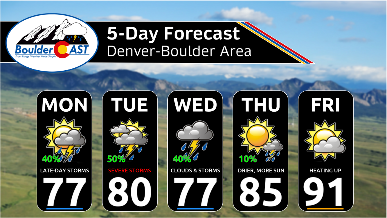
- Hot weather takes a break: Hot weather takes a break to start the week thanks to a cold frontal passage — highs much more comfortable in the 70s on Monday
- Stormy stretch ahead: Rain and storms are likely Monday through Wednesday, with surging moisture content leading to the chance of heavy downpours.
- Severe weather threat on Tuesday: Conditions on Tuesday will support severe storms, including hail, damaging winds, and a slight tornado risk in northeastern Colorado.
- Warming and drying late-week: By Thursday and Friday, high pressure builds back in, pushing temps back towards 90 degrees with mostly dry conditions—though out-of-state wildfire smoke could drift in at times.
DISCLAIMER: This weekly outlook forecast is created Monday morning and covers the entire upcoming week. Accuracy will decrease as the week progresses as this post is NOT updated. To receive daily updated forecasts from our team, among many other perks, subscribe to BoulderCAST Premium.

Go Premium, get all the perks.
Daily Forecast Updates
Get our daily forecast discussion every morning delivered to your inbox.
All Our Model Data
Access to all our Colorado-centric high-resolution weather model graphics. Seriously — every one!
Ski & Hiking Forecasts
6-day forecasts for all the Colorado ski resorts, plus more than 120 hiking trails, including every 14er.
Smoke Forecasts
Wildfire smoke concentration predictions up to 72 hours into the future.
Exclusive Content
Weekend outlooks every Thursday, bonus storm updates, historical data and much more!
No Advertisements
Enjoy ad-free viewing on the entire site.
Hot weather on pause as storm chances return
The much-talked-about heatwave showed up right on schedule late last week—and while it was definitely toasty, it didn’t get quite as intense as some early forecasts had feared. Boulder hit 98°F on Friday, breaking a daily record, and Denver tied its record at 99°F. Saturday cooled ever so slightly, landing at 97°, and by Sunday we finally got a bit of a breather with highs only around 90°.
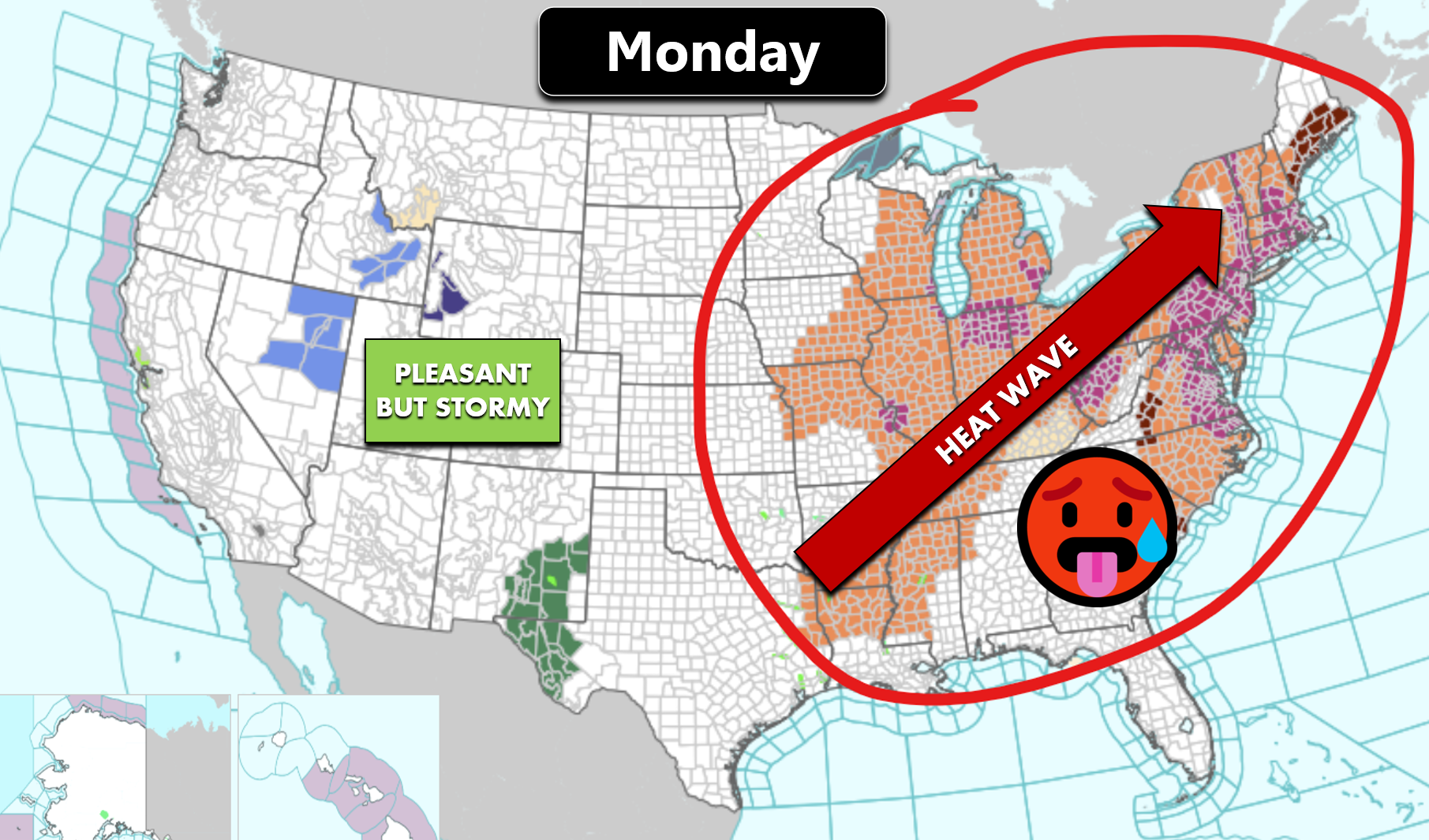
Thankfully, that sizzling stretch is behind us, at least for now, as the hot airmass vacates Colorado and engulfs most of the country to our east for several days ahead in a dangerous East Coast heatwave.
A punchy cold front rolled through Sunday night, giving us a refreshing start to the week with highs below normal for a change on Monday. The GEFS ensemble temperature plot below shows this downward trend from yesterday. Monday will be our coolest day of the week, with some locations in the mid 70s and the rest of Denver in the upper 70s. Come Tuesday and Wednesday, the frontal airmass will slowly weaken as warmer air builds back in. However, highs should stay near to slightly below average with storm chances holding in the forecast. Warmer air is projected to surge back in for the tail-end of the week with Front Range temperatures returning to the lower 90s by Friday.

As for rain? We’ve got our best shot early in the week—mainly Monday through Wednesday. Tuesday looks like the strongest contender for widespread showers and storms. There’s still a chance we’ll see some rain on Thursday and Friday, but by then the atmosphere will start rapidly drying out.

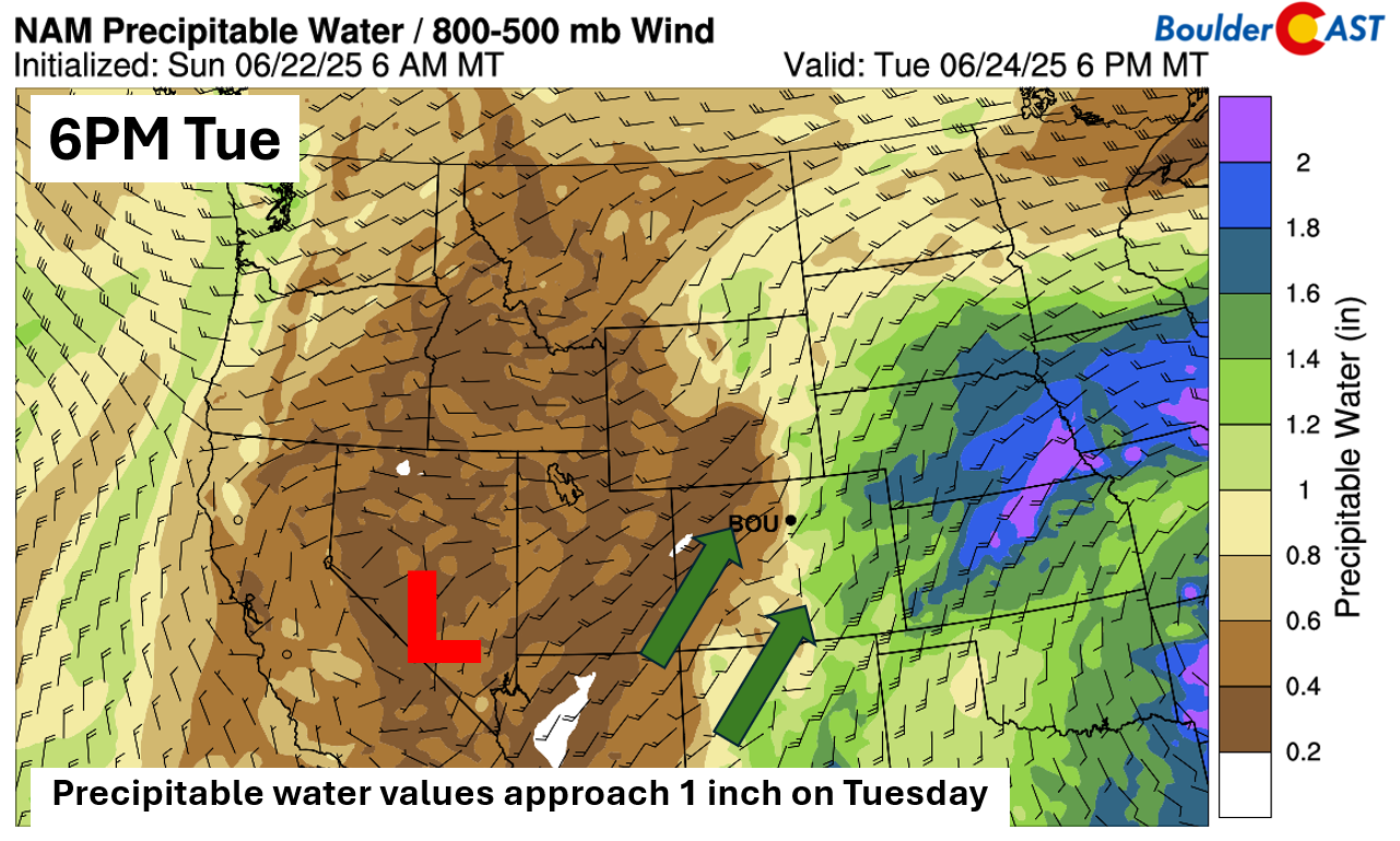
What’s driving the changing pattern? A slow-moving upper-level trough over the central Great Basin is pulling a lot of moisture northward into Colorado, along with much cooler air. That’s a big shift from the hot, dry pattern we saw last week. By Tuesday, moisture levels are expected to be well above normal, helping fire up storms over the Mountains and the Denver area alike. Plus, easterly winds at the surface will help keep those storms going once they cross the Rockies.
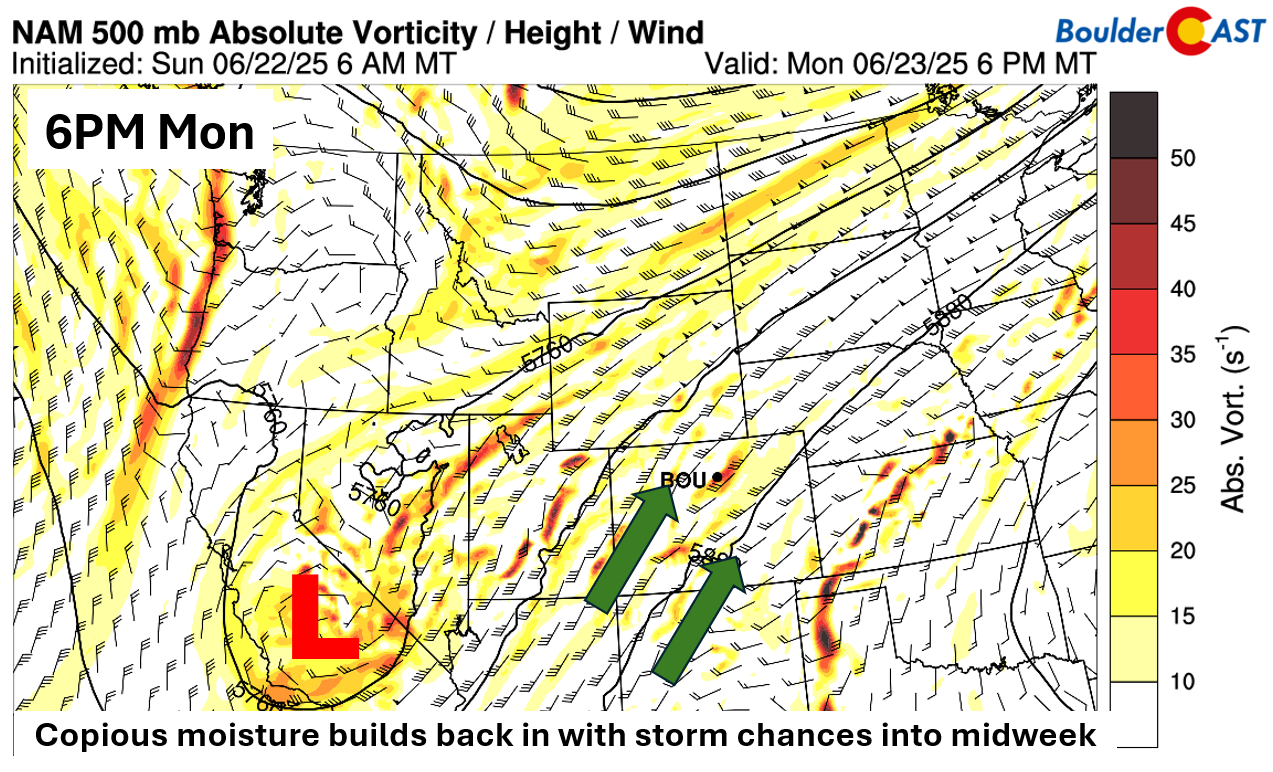
Tuesday, in particular, looks quite active. Some areas around the Denver Metro will see precipitable water values spike over one inch on Tuesday, with storms peaking late afternoon into the evening. That level of moisture means heavy downpours are a real possibility.
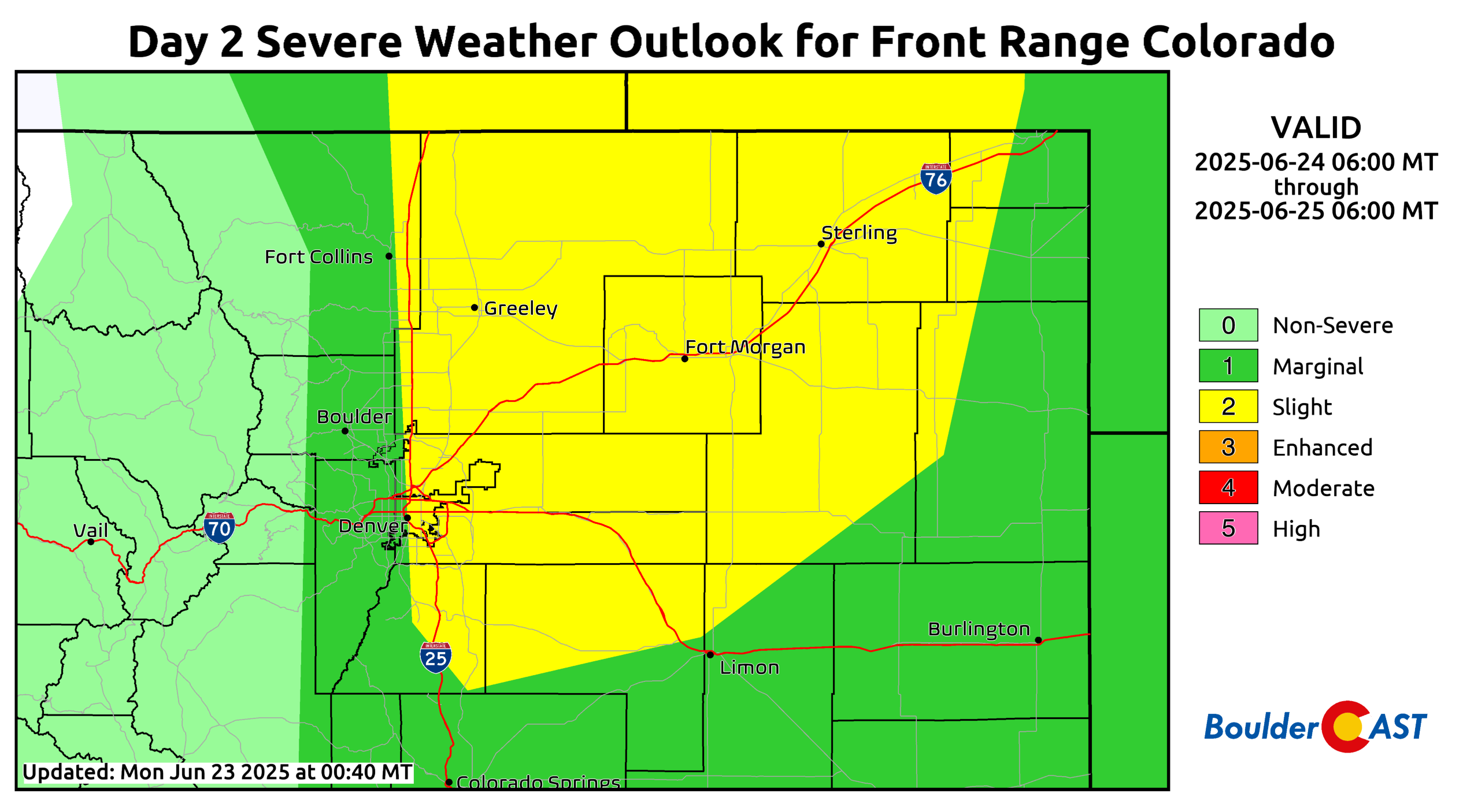
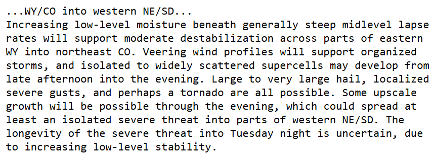
Furthermore, we are tracking a developing threat of severe thunderstorms on Tuesday. Instability values will be rather high, especially from Denver to the north and east. Along with that, shear values will be supportive of supercells favoring damaging winds and large hail. A tornado or two cannot be ruled out in the northeast part of the state with the indicated veering wind profiles.
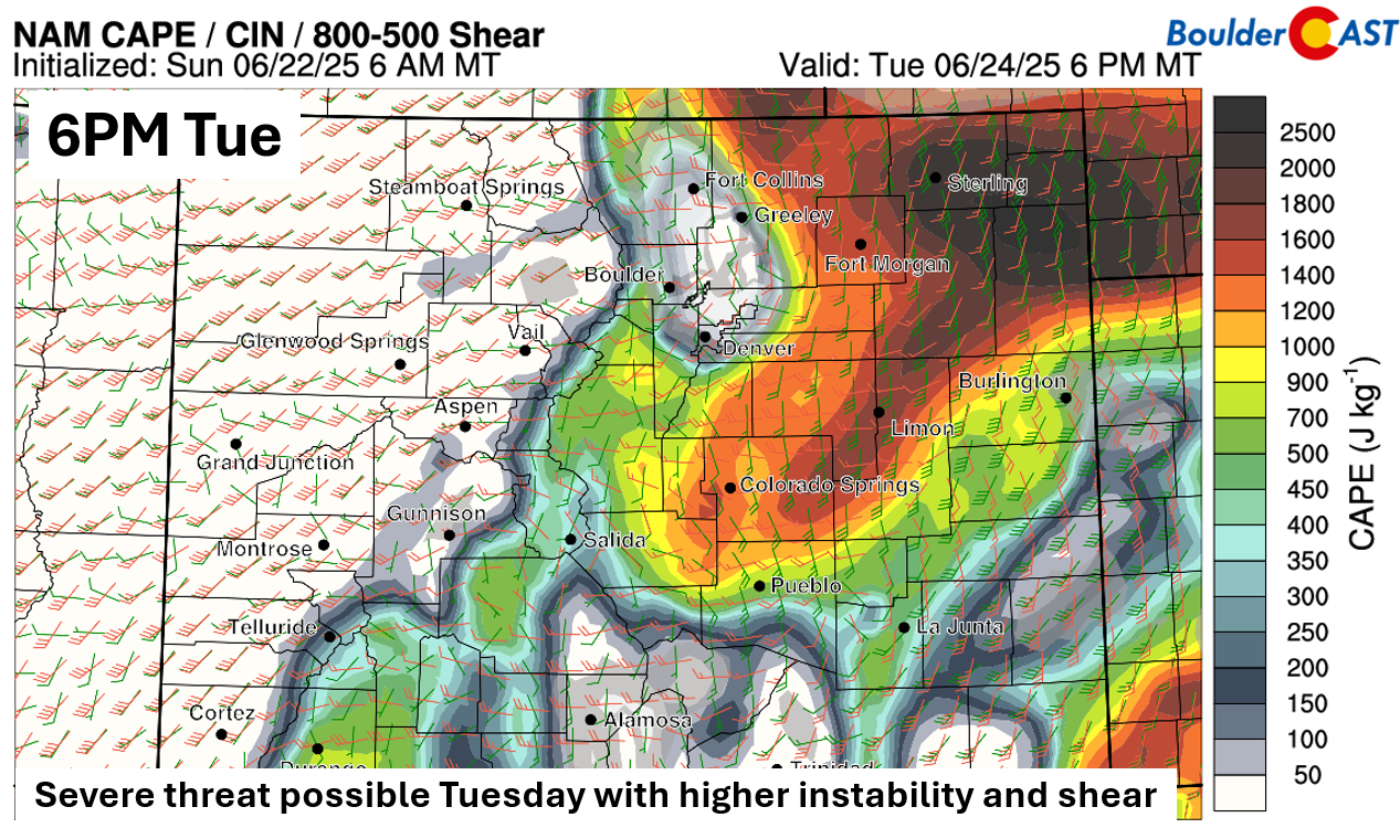
The Storm Prediction Center has already flagged a Slight Risk along and east of I-25 for Tuesday, with a Marginal Risk further west toward the Foothills, including in Boulder.
The SPC discussion for parts of Wyoming and Colorado mentions the same concerns we have:
Warming back up and drying out by late-week
Looking toward the end of the week, things will start to warm and dry up again. That trough breaks down by Thursday, and high pressure from Texas moves in. Expect temps to bounce back into the upper 80s and lower 90s by Friday. A pop-up storm can’t be ruled out—especially Thursday—but most of us will stay dry.
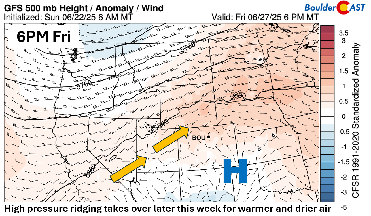
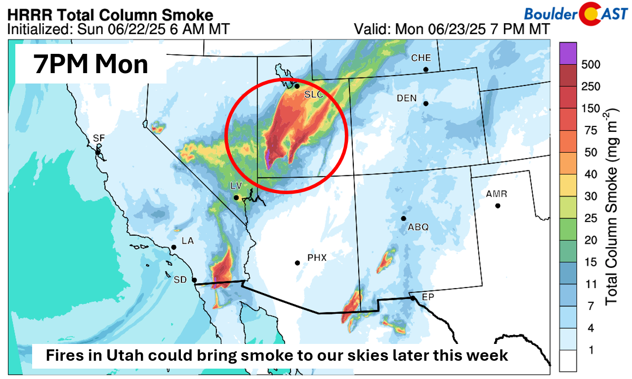
One last note: wildfires burning in southern Utah and parts of Mexico could send some smoke our way sometime later this week, depending on how upper-level winds shape up across the Southwest. For now, though, the ridge building in might keep most of that haze off to our northwest.
While cooler weather is definitely locked in the next few days, here’s hoping the rainy part of the forecast also delivers. Enjoy!
Forecast Specifics:
Monday: Partly cloudy, then increasing clouds with scattered showers and storms in the late afternoon and evening. Highs in the mid to upper 70s on the Plains and upper 60s in the Foothills.
Tuesday: Partly cloudy, then increasing clouds with scattered showers and storms in the late afternoon and evening. Some could be strong to severe, with large hail, damaging winds, and heavy rainfall. Highs in the upper 70s to low 80s on the Plains and near 70 in the Foothills.
Wednesday: Mostly cloudy with scattered showers and storms in the late afternoon and evening. Highs in the upper 70s to lower 80s on the Plains and lower 70s in the Foothills.
Thursday: Mostly sunny and warmer with just a slight chance of a stray storm. Highs in the mid to upper 80s on the Plains and mid to upper 70s in the Foothills.
Friday: Hot and dry with lower 90s on the Plains and near 80 in the Foothills.
Weekend: Staying warm with highs in the lower 90s and just a tiny chance of a stray storm each day, mainly across the higher terrain.
DISCLAIMER: This weekly outlook forecast is created Monday morning and covers the entire upcoming week. Accuracy will decrease as the week progresses as this post is NOT updated. To receive daily updated forecasts from our team, among many other perks, subscribe to BoulderCAST Premium.
Go Premium, get all the perks.
Daily Forecast Updates
Get our daily forecast discussion every morning delivered to your inbox.
All Our Model Data
Access to all our Colorado-centric high-resolution weather model graphics. Seriously — every one!
Ski & Hiking Forecasts
6-day forecasts for all the Colorado ski resorts, plus more than 120 hiking trails, including every 14er.
Smoke Forecasts
Wildfire smoke concentration predictions up to 72 hours into the future.
Exclusive Content
Weekend outlooks every Thursday, bonus storm updates, historical data and much more!
No Advertisements
Enjoy ad-free viewing on the entire site.
Enjoy our content? Give it a share!


You must be logged in to post a comment.