Get ready for a classic early summer setup—plenty of warmth, a hint of storm potential, a bit of wildfire smoke, and maybe even the year’s first 90-degree day(s) for the Front Range. While the week starts off dry and sunny, a few scattered storms will make an appearance midweek, adding a little variety to the forecast. By the weekend, the heat cranks up as a strong ridge sends hot air northward into Colorado.
This week’s highlights include:
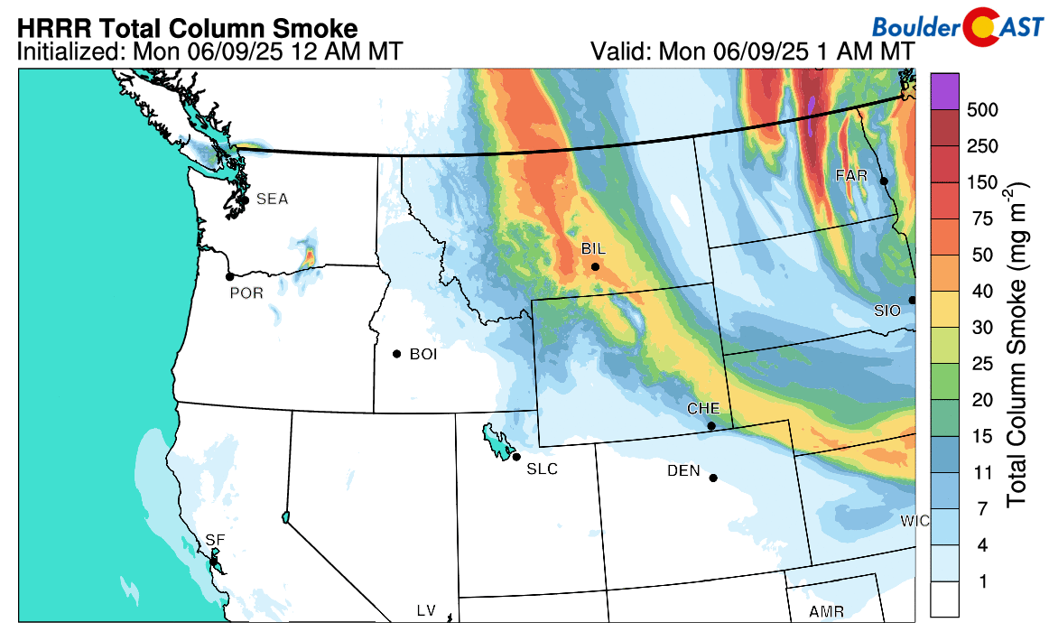
- Dry Start with Light Wildfire Smoke: Monday will be completely dry with sunshine, thanks to a dry northwest flow keeping storm activity at bay. Light smoke from Canadian wildfires will be around though.
- Warm Week: Temperatures climb into the mid-to-upper 80s from Tuesday through Friday, with weak ridging keeping things relatively dry.
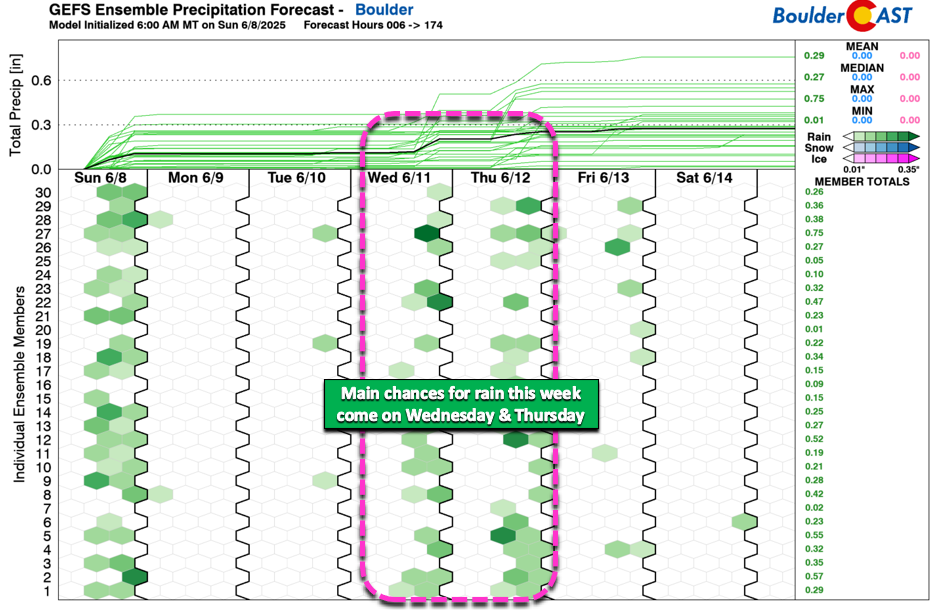
- Scattered Storms: Wednesday and Thursday will have some storms around as shortwaves pull in some moisture; Tuesday and Friday could also see a few over the higher terrain.
- Weekend Heat: A strong ridge will push hot air north, likely giving the Front Range a taste of widespread 90s over the weekend.
DISCLAIMER: This weekly outlook forecast is created Monday morning and covers the entire upcoming week. Accuracy will decrease as the week progresses as this post is NOT updated. To receive daily updated forecasts from our team, among many other perks, subscribe to BoulderCAST Premium.

Go Premium, get all the perks.
Daily Forecast Updates
Get our daily forecast discussion every morning delivered to your inbox.
All Our Model Data
Access to all our Colorado-centric high-resolution weather model graphics. Seriously — every one!
Ski & Hiking Forecasts
6-day forecasts for all the Colorado ski resorts, plus more than 120 hiking trails, including every 14er.
Smoke Forecasts
Wildfire smoke concentration predictions up to 72 hours into the future.
Exclusive Content
Weekend outlooks every Thursday, bonus storm updates, historical data and much more!
No Advertisements
Enjoy ad-free viewing on the entire site.
Heating up
Colorado starts the week under the influence of dry northwest flow, stuck between a deep trough in the Great Lakes and a strong ridge over the Pacific Northwest — Monday will be totally dry here. The rest of the week we’ll be situated within weak ridging — in fact, much of the nation will be in the same boat. This will help to keep us warm and somewhat dry Tuesday through Friday with weak westerly flow. By Saturday and Sunday, a strong ridge will take shape across the Dakotas with hot and dry air flowing northward from the Desert Southwest giving many residents of the Front Range their first taste of 90-degree temperatures for the year during the upcoming weekend.

Now, while that persistent warm ridge overhead will keep storm activity in check this week, we’re not totally in the clear. Wednesday and Thursday bring a chance for some widely scattered storms as shortwaves passing through Wyoming pull a little extra moisture into the mix. Nothing major—just some popcorn-style, non-severe storms creeping up in for the afternoons and evenings. Tuesday and Friday could also see a few storms, mostly over the higher terrain.
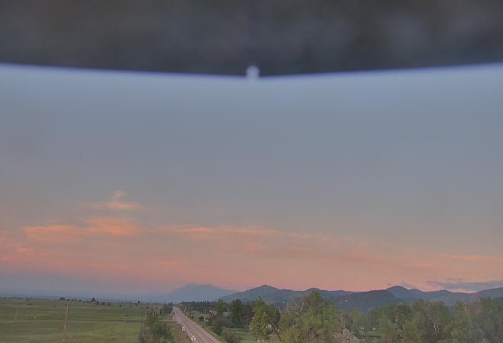
There will be some light Canadian wildfire smoke around early in the week, particularly on Monday, but it shouldn’t be too bad. Monday’s sunrise in eastern Boulder County clearly reveals some of this smoke polluting our air.
As a more zonal flow takes over through the week, smoke levels will decline as it gets pushed off to the east.
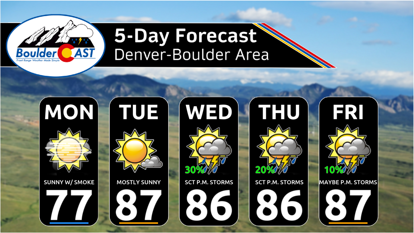
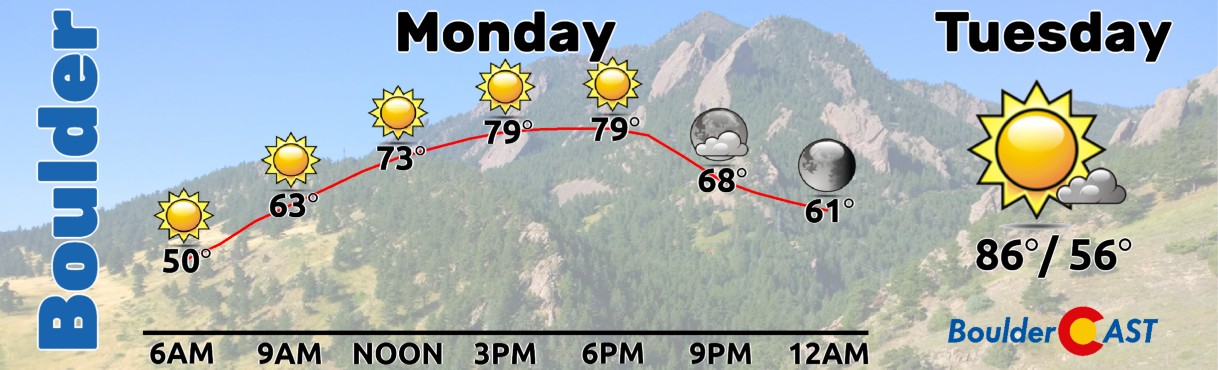
Highs Monday will be in the mid to upper 70s with full sunshine. Tuesday we return back well into the 80s again. Both days will be dry across the lower elevations.
Wednesday and beyond we push towards the upper 80s with 10 to 30 percent chances for storms. Enjoy!
Forecast Specifics:
Monday: Sunny and seasonal with highs in the mid to upper 70s on the Plains with middle 60s in the Foothills. Light smoke from fires in Canada will be around.
Tuesday: Lots of sunshine with a few isolated storms over the higher terrain. Highs in the middle to upper 80s on the Plains with lower 70s in the Foothills.
Wednesday: Morning sun, then partly cloudy with widely scattered late-day thunderstorms. Highs reach the mid to upper 80s on the Plains with middle 70s in the Foothills.
Thursday: Morning sun, then partly cloudy with widely scattered late-day thunderstorms. Highs reach the mid to upper 80s on the Plains with middle 70s in the Foothills.
Friday: Some clouds late with a slight chance of a thundershower in the afternoon or evening. Highs in the mid to upper 80s on the Plains with lower 70s in the Foothills.
Weekend: Mostly dry and hot with highs in the upper 80s to middle 90s.
DISCLAIMER: This weekly outlook forecast is created Monday morning and covers the entire upcoming week. Accuracy will decrease as the week progresses as this post is NOT updated. To receive daily updated forecasts from our team, among many other perks, subscribe to BoulderCAST Premium.
Go Premium, get all the perks.
Daily Forecast Updates
Get our daily forecast discussion every morning delivered to your inbox.
All Our Model Data
Access to all our Colorado-centric high-resolution weather model graphics. Seriously — every one!
Ski & Hiking Forecasts
6-day forecasts for all the Colorado ski resorts, plus more than 120 hiking trails, including every 14er.
Smoke Forecasts
Wildfire smoke concentration predictions up to 72 hours into the future.
Exclusive Content
Weekend outlooks every Thursday, bonus storm updates, historical data and much more!
No Advertisements
Enjoy ad-free viewing on the entire site.
Enjoy our content? Give it a share!


You must be logged in to post a comment.