
The last two weeks have been considerably colder than normal across the Front Range (thanks Flatiron Freddy!), but that changes this week as the atmospheric pendulum swings the other direction ushering in a welcomed pattern shift across all of Colorado. The week ahead will be largely dry in our area with temperatures well above normal every day except Wednesday. The beautiful conditions will continue through the upcoming weekend, but the first week of March will see a return of cooler and unsettled weather with rain and snow chances in tow.
This week’s highlights include:
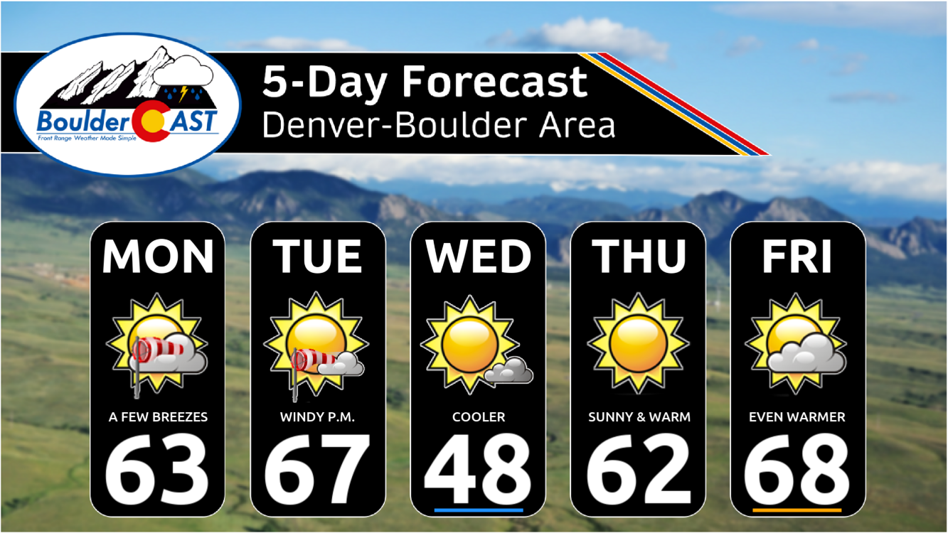
- Warm Breezes Monday & Tuesday: Gusty downslope winds will impact the area early in the week, but temperatures will be in the 60s
- Mid-Week Cooldown: A mostly dry cold front will pass through late on Tuesday and will bring cooler more seasonal temperatures for Wednesday with highs in the 40s
- Warmth Returns Quickly Late Week: A strong ridge will reform quickly late-week with temperatures rebounding back into the 60s to near 70 degrees
- Another Beautiful Weekend Ahead: Warm weather is expected to persist through the upcoming weekend alongside dry conditions
- Turning Cooler & Unsettled Next Week: Though still uncertain, next week looks to turn colder with chances for rain/snow returning!
DISCLAIMER: This weekly outlook forecast is created Monday morning and covers the entire upcoming week. Accuracy will decrease as the week progresses as this post is NOT updated. To receive daily updated forecasts from our team, among many other perks, subscribe to BoulderCAST Premium.

Go Premium, get all the perks.
Daily Forecast Updates
Get our daily forecast discussion every morning delivered to your inbox.
All Our Model Data
Access to all our Colorado-centric high-resolution weather model graphics. Seriously — every one!
Ski & Hiking Forecasts
6-day forecasts for all the Colorado ski resorts, plus more than 120 hiking trails, including every 14er.
Smoke Forecasts
Wildfire smoke concentration predictions up to 72 hours into the future.
Exclusive Content
Weekend outlooks every Thursday, bonus storm updates, historical data and much more!
No Advertisements
Enjoy ad-free viewing on the entire site.
Finally a warm week!
Happy Monday, everyone! After two straight weeks of (mostly) below normal temperatures — in some cases, wildly so — we finally got rewarded with a few warmer days over this past weekend, with highs Saturday in the 50s, with Sunday surging well into the 60s. That wet blanket of snow from Friday is nothing but a distant memory!
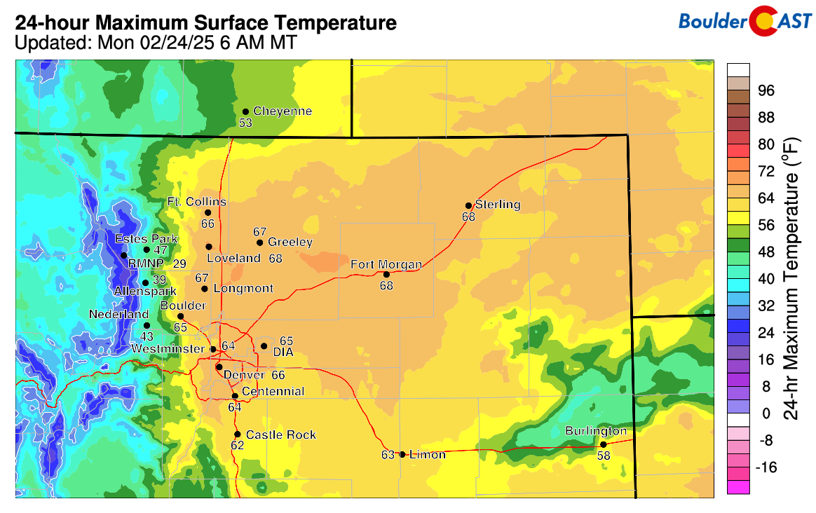
Sunday’s high temperatures were amazing!
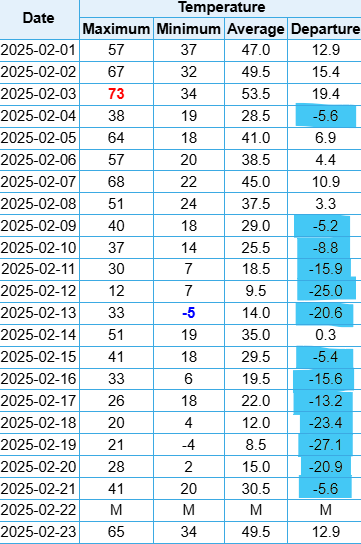
The table below shows Boulder’s high and low temperatures in February so far. The first week of the month was pretty nice, including on February 2nd when Flatiron Freddy peeped his shadow predicting six more weeks of winter. That silly stuffed marmot was seemingly onto something the last few weeks, but that changes as we head into the final days of February with a big shift towards warmer weather now under way!
This week’s weather in Colorado will be dominated by a broad area of high pressure that will be situated across the western United States. Around mid-week the big and warm ridge will get beaten down somewhat by a passing disturbance coming across the northern Rockies. This will briefly bring cooler conditions for Wednesday, but otherwise it will be down-right springlike in the Front Range the next seven days!
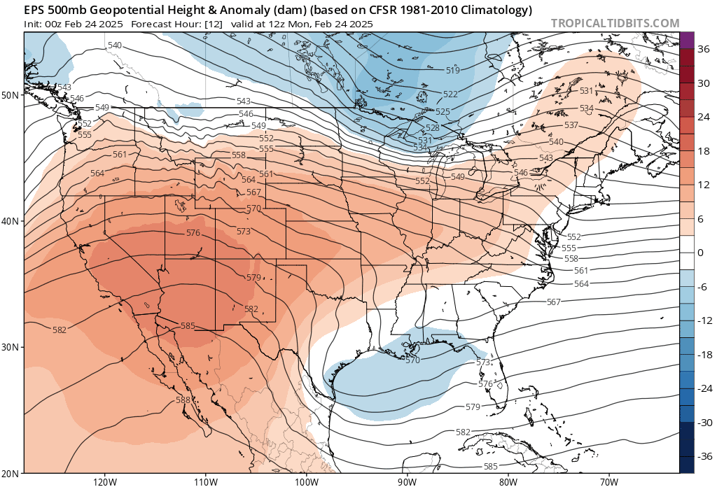
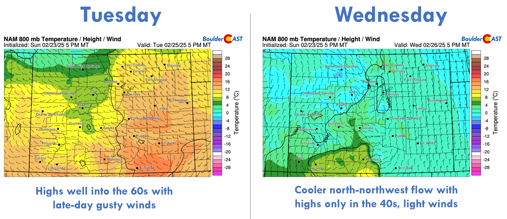
Colorado will be under strong westerly flow early in the week with our biggest weather concern being gusty downslope winds. Monday will feature a strong mountain wave setup much of the day with gusts over 65 MPH in the higher Foothills west of the Metro area. A few sporadic gusts of 20 to 30 MPH may occur across the lower elevations, but these won’t be too much of an issue. As we head into Tuesday, westerly winds are expected to become more widespread, with gusts over 30 MPH for much of area during the afternoon and evening. Some gusts upwards of 50 MPH may occur around Boulder and other western suburbs. Both Monday and Tuesday will be very pleasant with temperatures pushing into the middle 60s — at least it will be a warm wind!

In addition to the uptick in winds, late in the day Tuesday will feature a cold front working south across the High Plains tied to the aforementioned storm passing along the Canadian border. The front should arrive into our area during the early evening hours and won’t feature must moisture or energy, though there could be a few isolated showers during the evening as the front passes. The best chance to see a little precipitation with Tuesday evening’s front will be in the Mountains (spotty rain/snow mix) and across the eastern Plains (a couple of thunderstorms), but overall the chance in our immediate area is rather low — less than 5%.
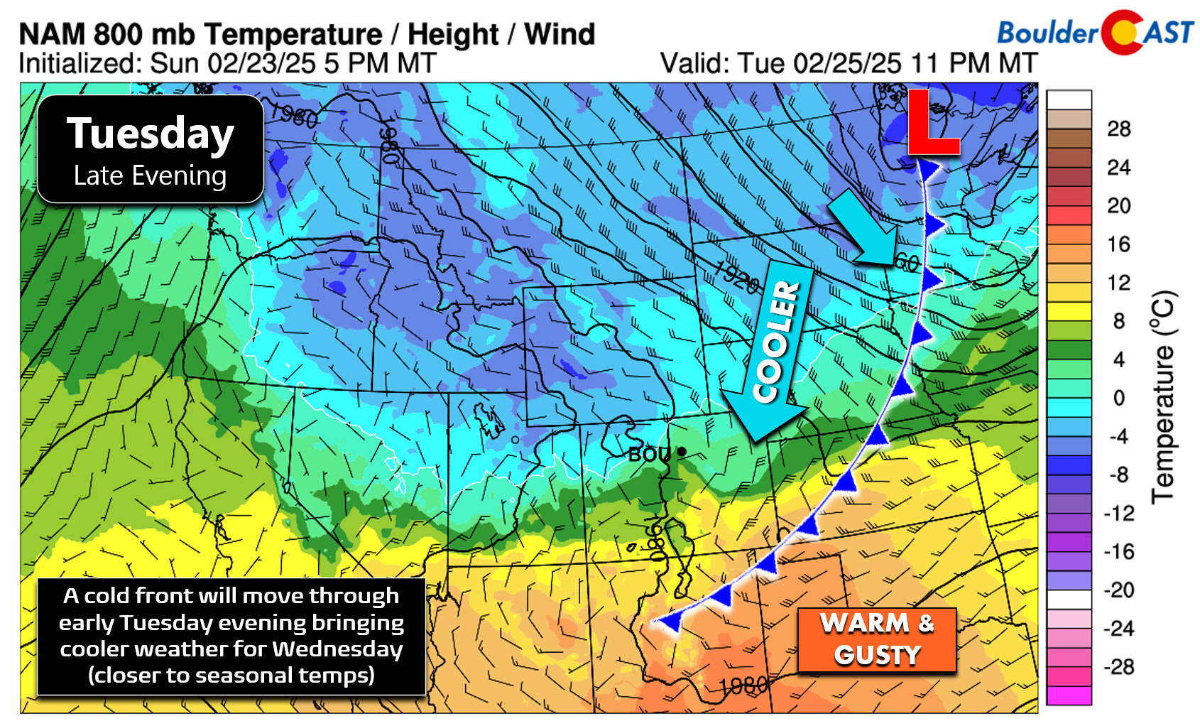
Temperatures on the backside of the cold front will tumble down towards normal with readings on Wednesday in the 45 to 50°F range, about 20° cooler than our toasty Tuesday!
By Thursday, the ridge of high pressure will quickly recover from the mid-week disturbance, likely becoming even more amplified than it was earlier in the week.
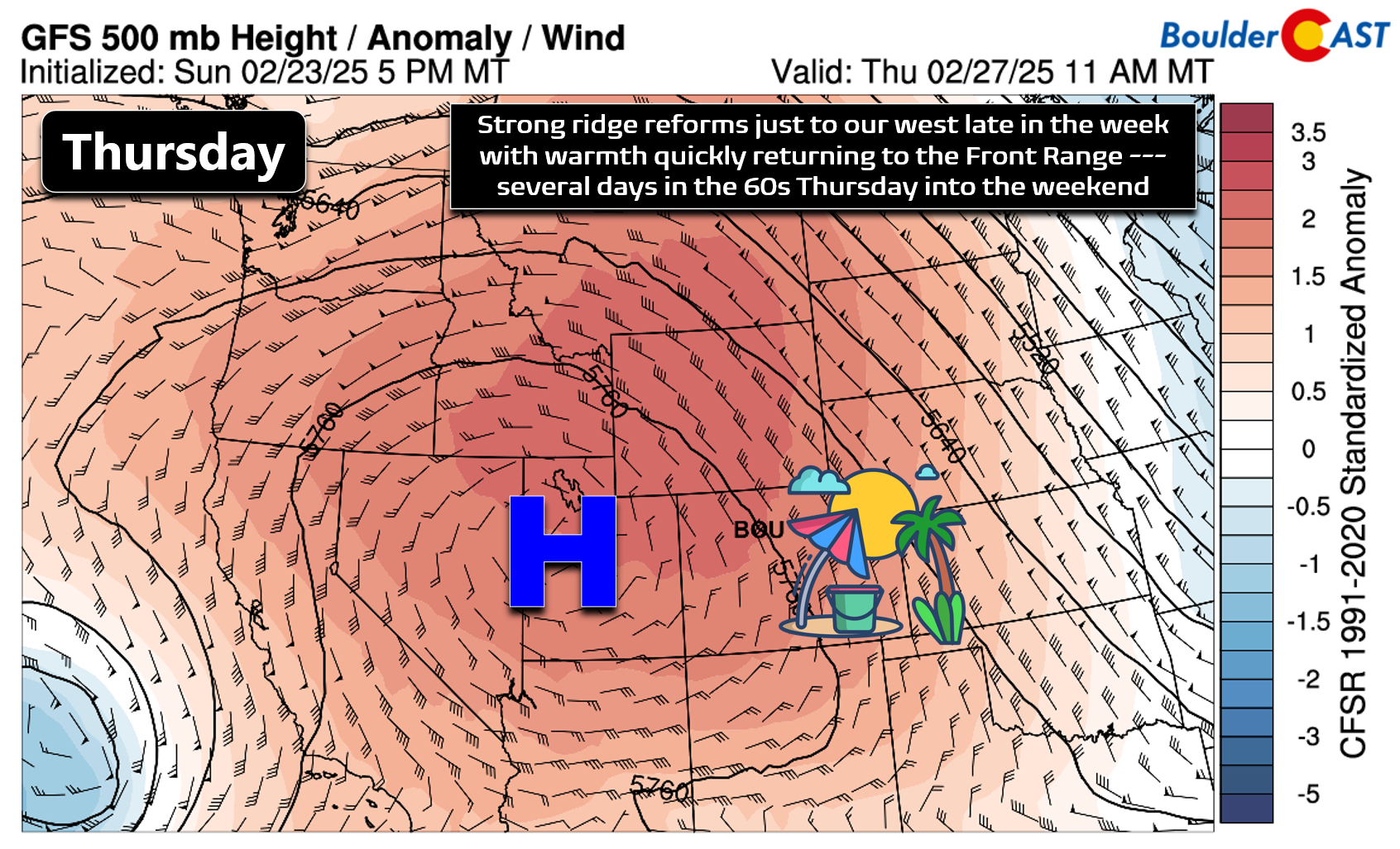
With strong high pressure situated near Salt Lake City Thursday into Friday, we’ll end the work-week on a pleasant note with temperatures shooting right back up into the 60s by Thursday, with Friday even having a chance of hitting 70 degrees! In case you are wondering, all of our record high temperatures are in the low to middle 70s this time of year, so at this point, we’re not predicting any record warmth this week.
The weekend ahead will stay very warm in the 60s across the area with no chance of precipitation either. Sunday will be the ninth straight totally dry day for Boulder!

Don’t get too comfortable with the spring-like weather, though. The extended forecast shows a shift towards more unsettled weather taking hold across Colorado by early next week, with 60-degree temperatures a thing of the past.
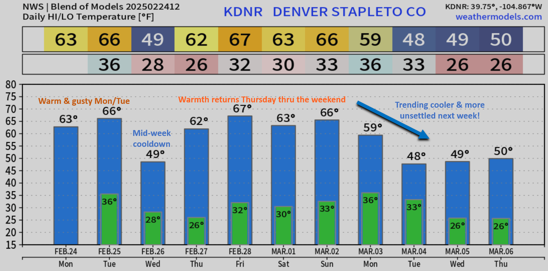
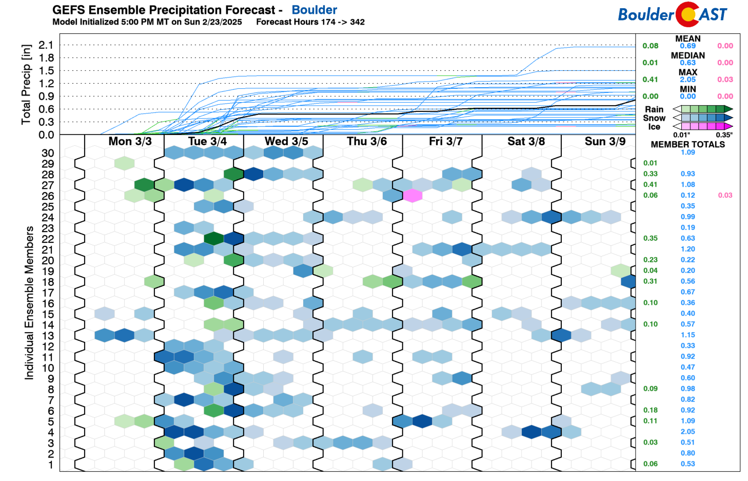
There’s still a lot of uncertainty, but at minimum we should see a trend back towards normal readings next week with increasing chances for precipitation in the form of rain and snow. Early ensemble signatures pinpoint Monday night or Tuesday as a strong candidate for our next chance of an organized storm system. For now, plan on cooler and more unsettled weather next week with snow likely returning to the forecast in the front half of the week.
Enjoy the wonderful weather out there this week — it’s not going to last forever!
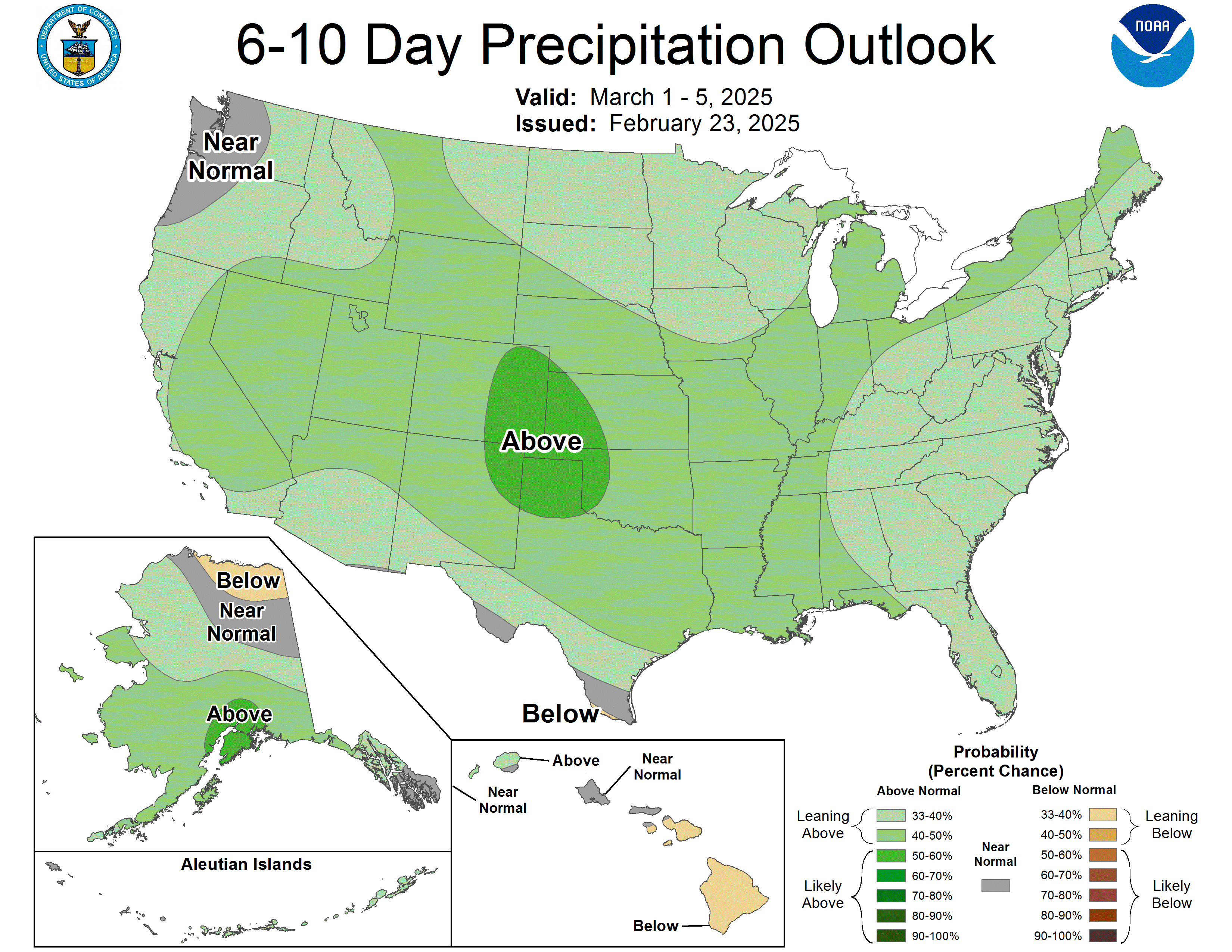
CPC outlook shows a strong chance for above normal precipitation next week in eastern Colorado
Forecast Specifics:
Monday: Partly cloudy and warm with sporadic wind gusts up to 25 MPH across the Metro area. Winds in the higher Foothills will gust over 60 MPH. Highs in the low to middle 60s on the Plains with upper 40s in the Foothills.
Tuesday: Mostly sunny and very warm with winds picking up after noon. Gusts of 30+ MPH will be common during the afternoon and evening, with gusts up to 50 MPH around Boulder. High temperatures soar into the middle to upper 60s on the Plains, with lower 50s in the Foothills. There’s a slight chance of an evening shower or storm, mainly well east of Denver and in the Mountains.
Wednesday: Mostly sunny and cooler with light winds. Temperatures top out in the mid to upper 40s on the Plains with upper 30s in the Foothills.
Thursday: Springlike conditions return under sunny skies. Look for readings in the lower 60s on the Plains and in the upper 40s in the Foothills.
Friday: Partly cloudy and very warm. Highs may encroach on 70 degrees for the lower elevations, with middle 50s in the Foothills.
Weekend: Staying warm and dry with temperatures topping out in the 60s both days.
Get BoulderCAST updates delivered to your inbox:
DISCLAIMER: This weekly outlook forecast is created Monday morning and covers the entire upcoming week. Accuracy will decrease as the week progresses as this post is NOT updated. To receive daily updated forecasts from our team, among many other perks, subscribe to BoulderCAST Premium.
Go Premium, get all the perks.
Daily Forecast Updates
Get our daily forecast discussion every morning delivered to your inbox.
All Our Model Data
Access to all our Colorado-centric high-resolution weather model graphics. Seriously — every one!
Ski & Hiking Forecasts
6-day forecasts for all the Colorado ski resorts, plus more than 120 hiking trails, including every 14er.
Smoke Forecasts
Wildfire smoke concentration predictions up to 72 hours into the future.
Exclusive Content
Weekend outlooks every Thursday, bonus storm updates, historical data and much more!
No Advertisements
Enjoy ad-free viewing on the entire site.
Enjoy our content? Give it a share!


You must be logged in to post a comment.