This week will feature a mixture of calm and chaos in Front Range Colorado! While the early part of the week will be relatively quiet with cool temperatures, a significant change in our weather is brewing for Friday. An Arctic blast is set to slam eastern Colorado during the late-day period, ushering in the coldest air of the season this weekend alongside widespread snowfall. Enjoy the sunshine and mild conditions the next several days, but begin preparations for the deep freeze and snowy conditions ahead!
This week’s highlights include:
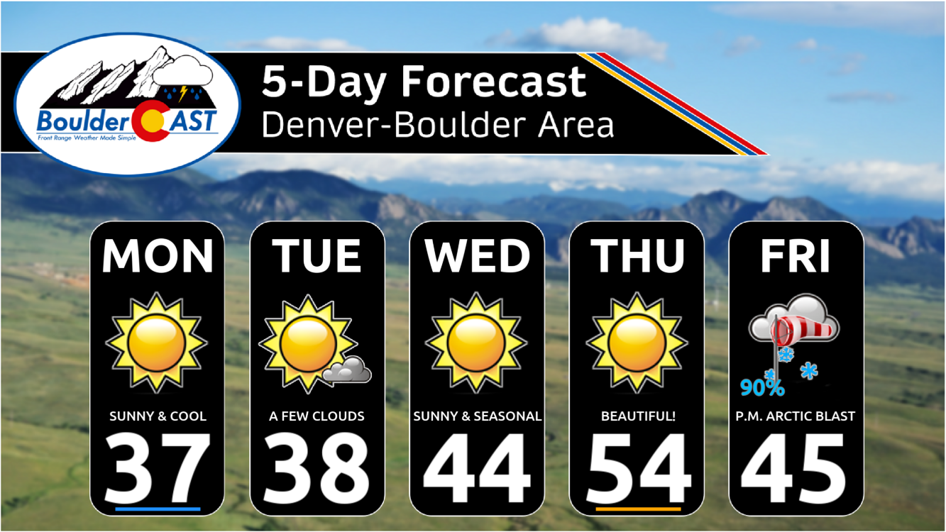
- Calm Early Week Weather: The early part of the week will be calm and cool with temperatures below average, but no significant precipitation is expected across the Front Range.
- Mid-Week Warm-Up: Temperatures will moderate nicely by Wednesday and Thursday, reaching the middle 40s to 50s, providing a pleasant couple days great for outdoor activities!
- Arctic Blast on Friday: An Arctic cold front will arrive late on Friday, bringing the coldest air of the season alongside a period of snow for the entire area. Snow totals in excess of 3 inches are expected everywhere, with up to 10 inches possible in favored upslope areas.
- Weekend Stays Bitter Cold: The weekend will see extremely cold temperatures, with highs below 15°F on Saturday and likely below 10°F on Sunday.
- Even Colder Monday? A secondary surge of Arctic air may work into the area Sunday night, paving the way for even colder temperatures (and maybe more snow) heading into Monday
DISCLAIMER: This weekly outlook forecast is created Monday morning and covers the entire upcoming week. Accuracy will decrease as the week progresses as this post is NOT updated. To receive daily updated forecasts from our team, among many other perks, subscribe to BoulderCAST Premium.
Daily Forecast Updates
Get our daily forecast discussion every morning delivered to your inbox.
All Our Model Data
Access to all our Colorado-centric high-resolution weather model graphics. Seriously — every one!
Ski & Hiking Forecasts
6-day forecasts for all the Colorado ski resorts, plus more than 120 hiking trails, including every 14er.
Smoke Forecasts
Wildfire smoke concentration predictions up to 72 hours into the future.
Exclusive Content
Weekend outlooks every Thursday, bonus storm updates, historical data and much more!
No Advertisements
Enjoy ad-free viewing on the entire site.
Quiet through Thursday, but things change big-time on Friday!
Our weather throughout the early part of the week won’t be changing much from recent times, with a stagnant setup across the nation lingering a few more days. However, eastern Colorado’s first real Arctic blast of the season is looming and will arrive late in the day Friday with snow and sub-zero temperatures in-tow! More on the incoming Arctic chill in a moment…
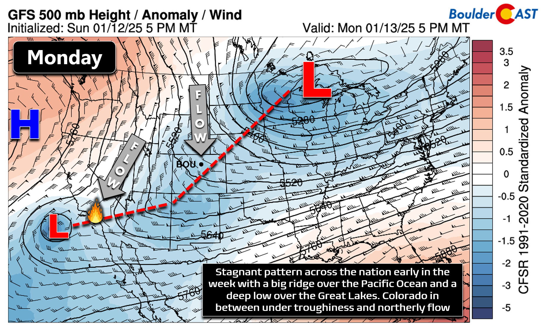
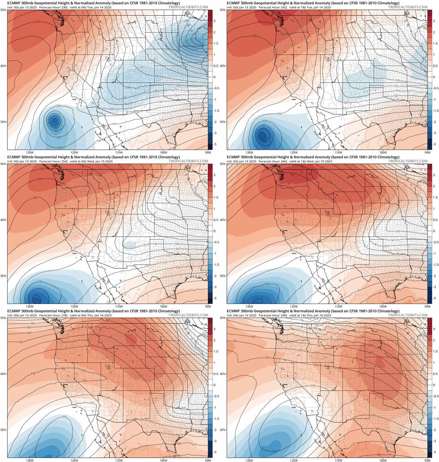
The early week weather pattern will be characterized by a deep low pressure in the Great Lakes, strong high pressure offshore over the northeast Pacific Ocean, and weak but notable troughing here in Colorado where we will be under northerly flow aloft for several more days. Our temperatures will remain cool and below average through Wednesday as a result of this setup, but nothing too bad really — especially considering what’s in the pipeline for the upcoming weekend!
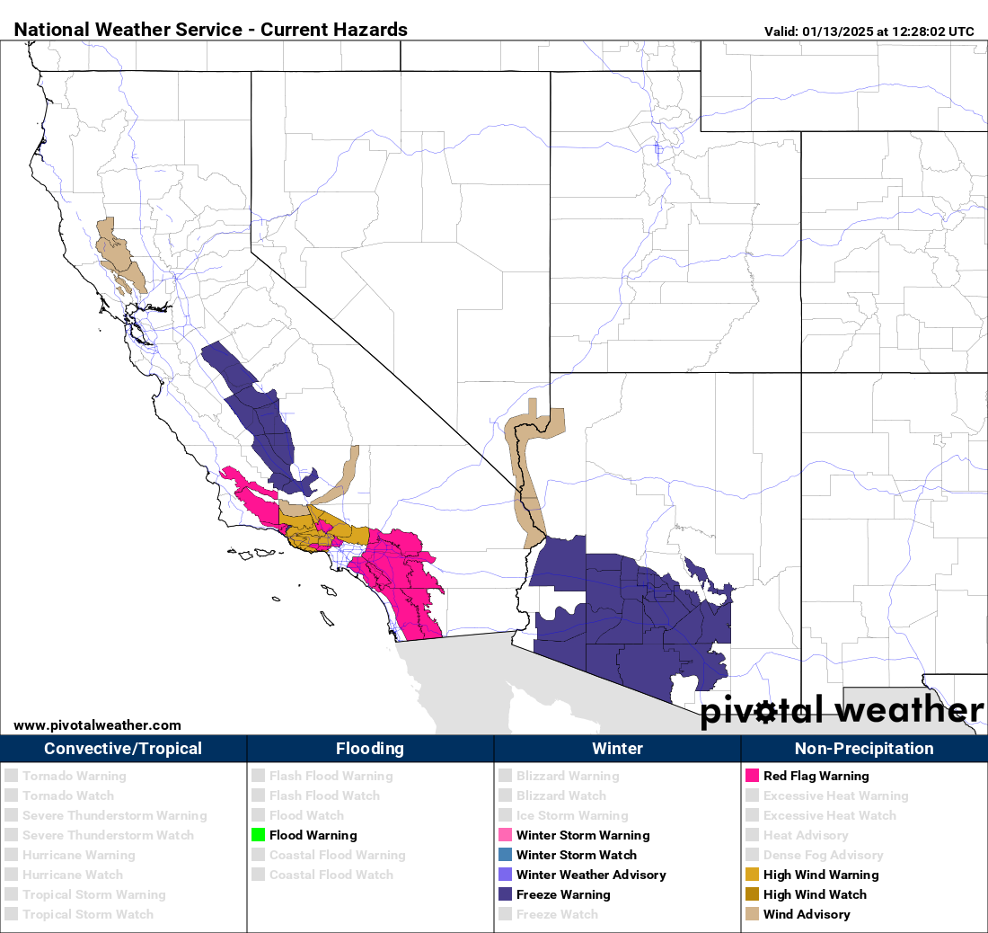
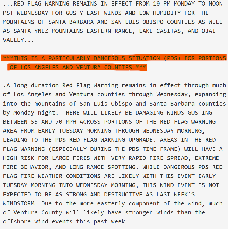
Unfortunately this atmospheric setup will lead to a resurgence of the Santa Ana winds and extreme fire danger across southern California Monday night through Wednesday. Our heart goes out to the hundreds of thousands of people directly impacted by the ongoing devastating urban wildfires there and the millions of people indirectly impacted by the thick smoke and/or general chaos in the city. To put things into perspective, the ongoing California fires dwarf the Marshall Fire in their magnitude of destruction — they are likely to become if not already the costliest wildfires in United States’ history.
The National Weather Service in Los Angeles has issued another Particularly Dangerous Situation (PDS) long-duration Red Flag Warning for the area early this week lasting about 36 hours. This is as bad of news as it gets, especially considering multiple large, uncontained and extremely dangerous urban fires are already burning in the area.
Back across Colorado, as we already mentioned, our early week period will be rather calm but cool under this northerly flow setup. The trough overhead will have numerous embedded weak shortwaves, none of which will bring any precipitation to the lower elevations though. The only minor concern will be light snow showers across the Mountains north of Interstate 70 on Tuesday (with minor accumulations of less than 2″ at most). High temperatures across the Boulder-Denver area will top out in the upper 30s both Monday and Tuesday with lots of sunshine to enjoy!
Wednesday into Thursday will see temperatures moderate nicely in the Front Range as that Pacific high pressure moves onshore and quickly passes across the northern Rockies, though it will be breaking down as it moves through our area. The result will be moderating temperatures, back into the middle 40s by Wednesday and even warmer into the 50s by Thursday when the ridge is overhead. Our house has been waiting for a pleasant and warm day to take down the Christmas lights — a wait that will finally end Thursday. Considering what is coming Friday into the weekend, you should plan to take advantage of the beautiful weather on Thursday in any way possible!
Arctic Blast arrives late Friday!
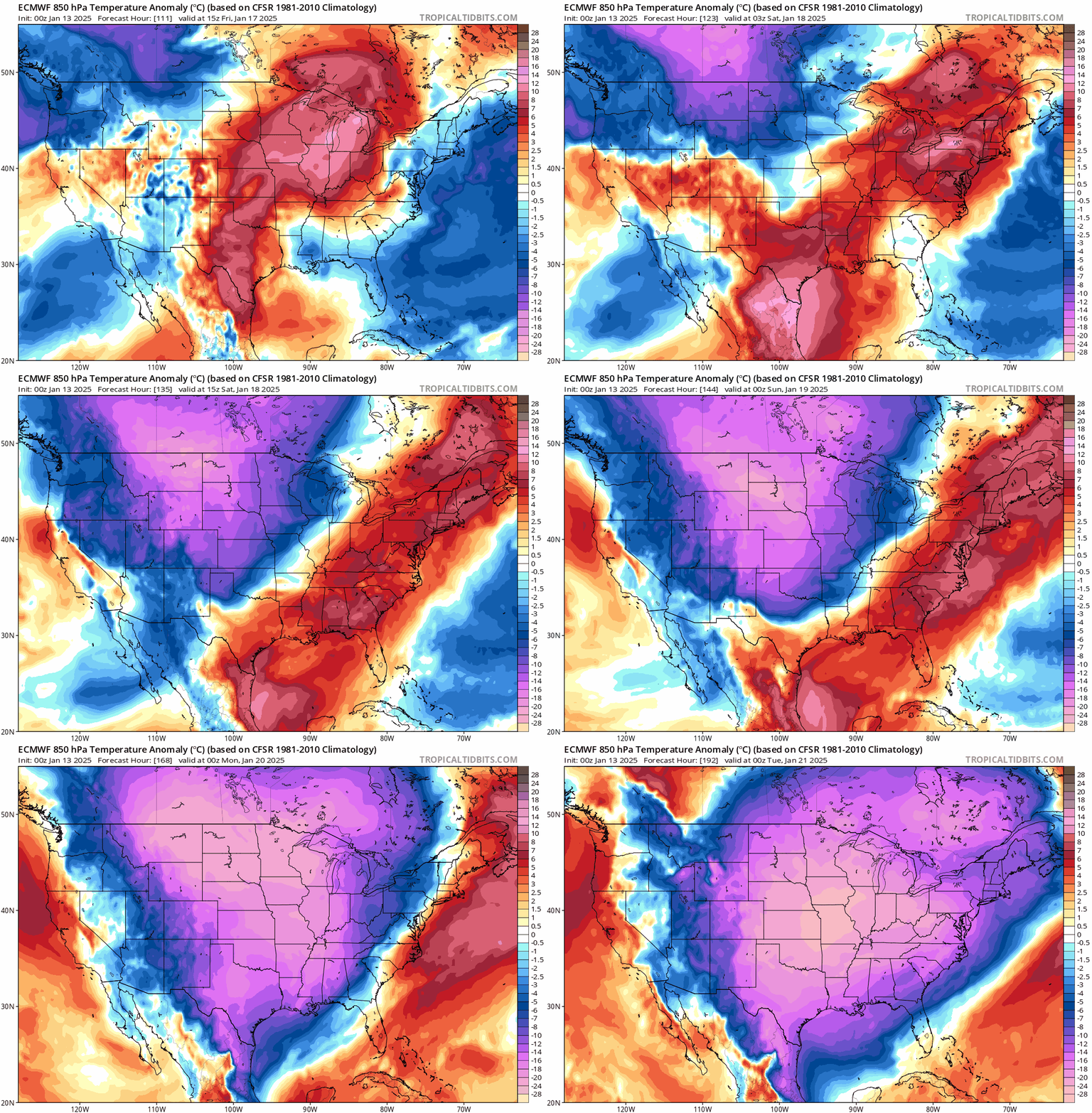
Friday is definitely the day to watch in this week’s forecast as Arctic air is going to be surging southward across the center of the country, blasting into northeast Colorado during the second half of the day ushering in the coldest air of the season for the weekend into early next week. Though still four and a half days out, there is indeed strong ensemble support for this Arctic air to reach our entire area, and models have been projecting this outcome for days. At this point, confidence is extremely high for a major change in our weather looming during the back half of Friday! As you can see in the low-level temperature anomaly forecast animation below for Thursday through Monday, almost no where in the continental United States will be spared from this Arctic outbreak!
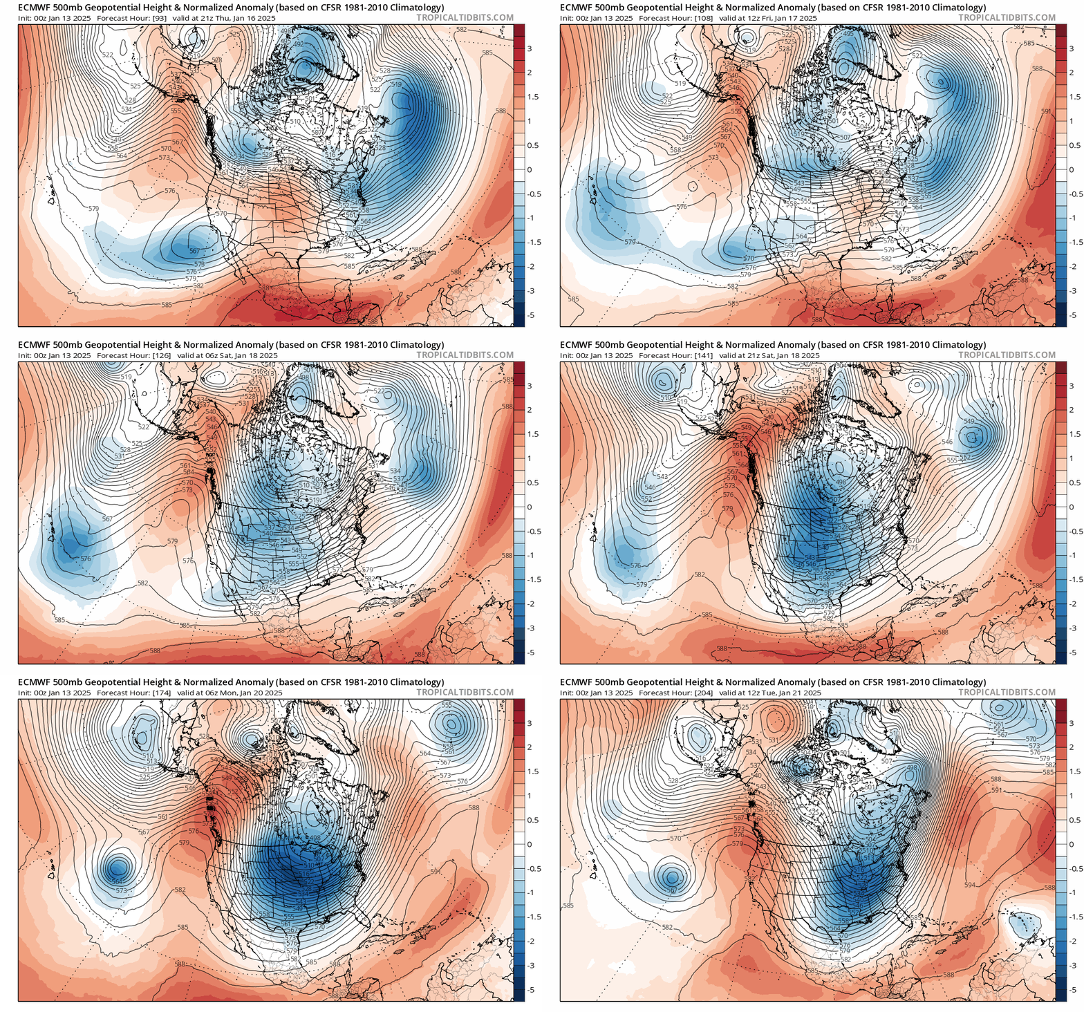
Looking bigger picture, we can see a classic setup for Arctic air to spill into Colorado, with a highly amplified ridge of high pressure stretching northward into Alaska this weekend — a pattern that we haven’t really seen materialize yet this winter, with most Arctic outbreaks thus far never coming this far west into our area. Luckily this ridge doesn’t linger too long over the Last Frontier; it’s forecast to break down by Tuesday of next week or so, but that will still allow for at least three or four extremely cold days in our neck of the woods before milder air works back into the region around the middle of next week.
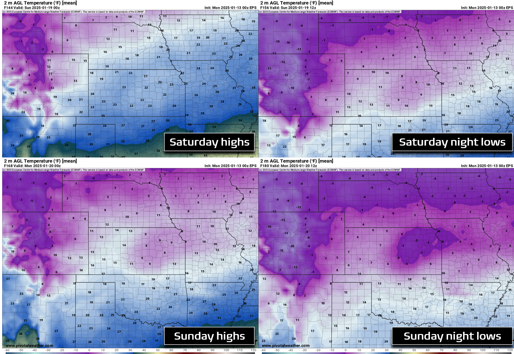
It’s still a bit early to forecast exactly how cold it will get this weekend, but for now let’s just take a look at ensemble means from the European suite. We’re looking at middle of the road high temperatures around 10 to 15°F on Saturday — those readings will likely be falling through the day as the Arctic air continues to ooze in. Saturday night’s lows will almost certainly drop below zero across most of the area, regardless if skies clear out or not. Sunday’s highs will be even colder, likely between -5° and +5°F for the Metro area. Sunday night’s temperatures once again plummet well below zero. There is even decent model support for a secondary blast of Arctic air to arrive Sunday evening or night, ultimately making Monday even colder than the weekend days. While still quite uncertain, daytime highs could end up below zero for the entire area next Monday!
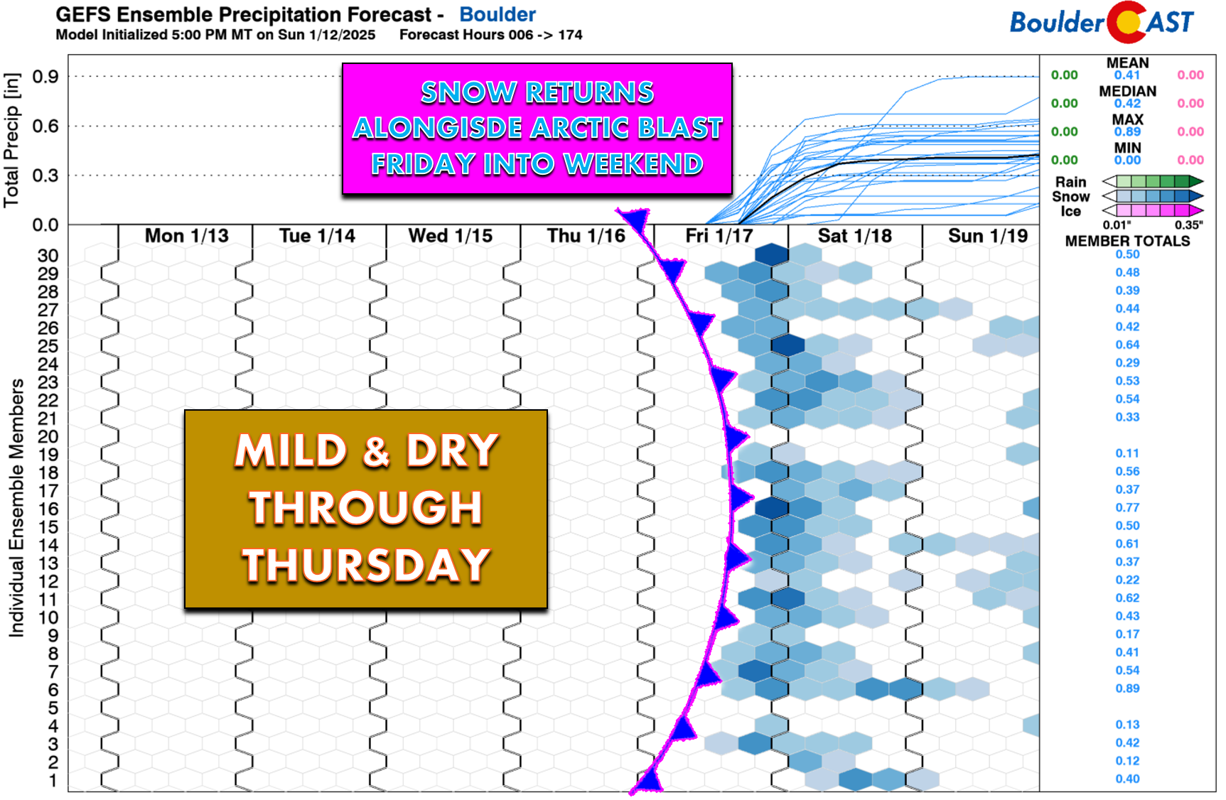
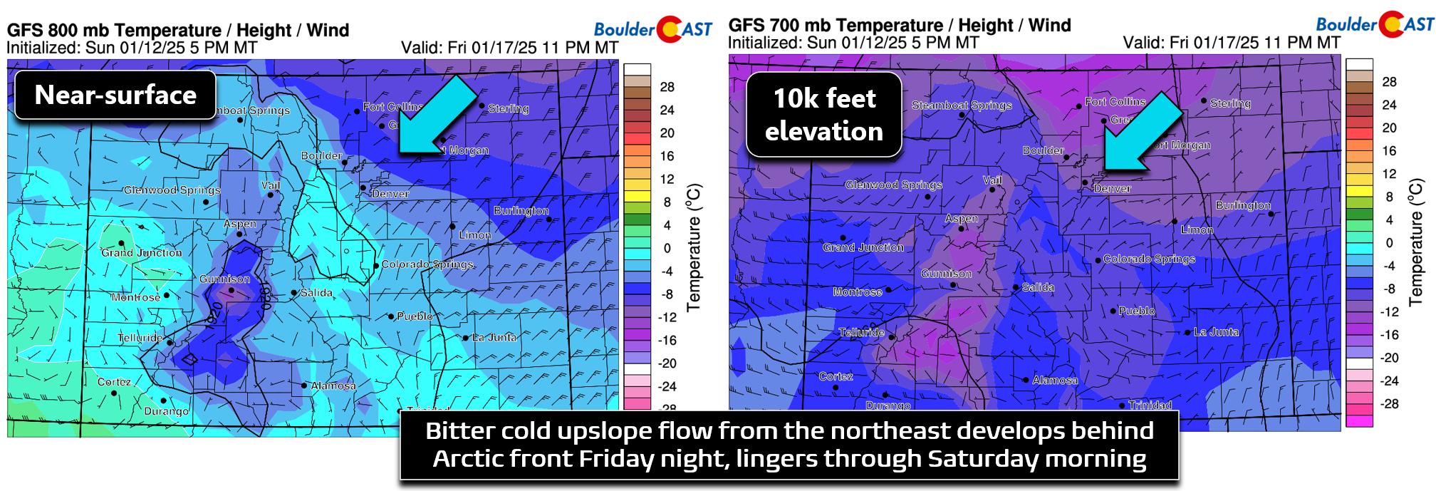
In addition to the bone-chillingly cold temperatures, the initial Arctic front will be followed by a prolonged period of deep upslope flow with enough moisture to support light snowfall for our area Friday evening into Saturday morning.
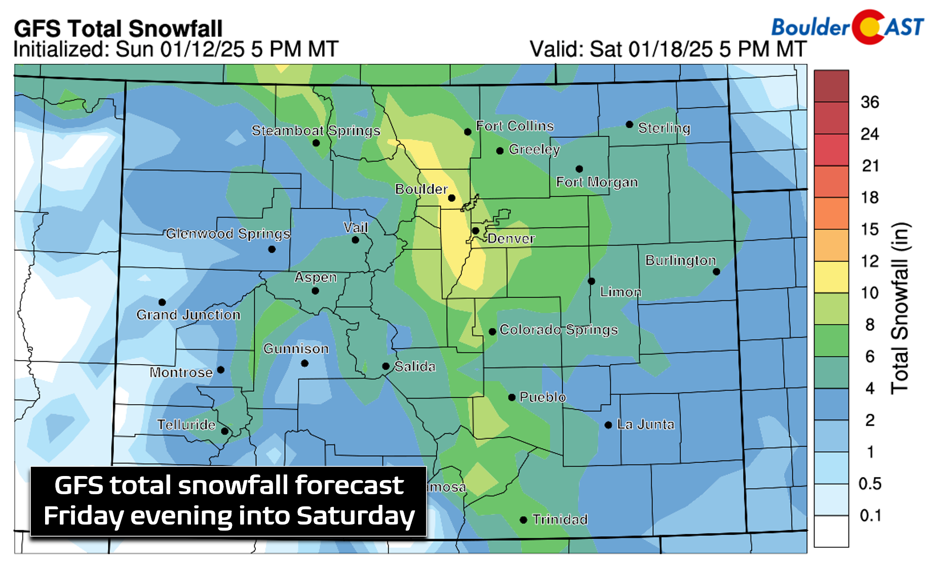
Given the very cold temperatures, snow ratios should be pretty high (15:1 or greater), so whatever moisture we can squeeze out of this cold and inherently dry Arctic airmass will add up quickly in the form of fluffy snow. The GFS forecast, combined with our team’s custom snow ratios applied, produces a widespread 5 to 10″ of snow across the area resulting from about 18 hours of upslope flow. The Euro model forecast is very similar to this right now, so that gives us some hope for these generous totals to come to fruition. Keep in mind this is still an extended range forecast, but this post-frontal setup will almost certainly be a favorable one for the entire Metro area, particularly around Boulder and the western suburbs which will cash in on the upslope most.
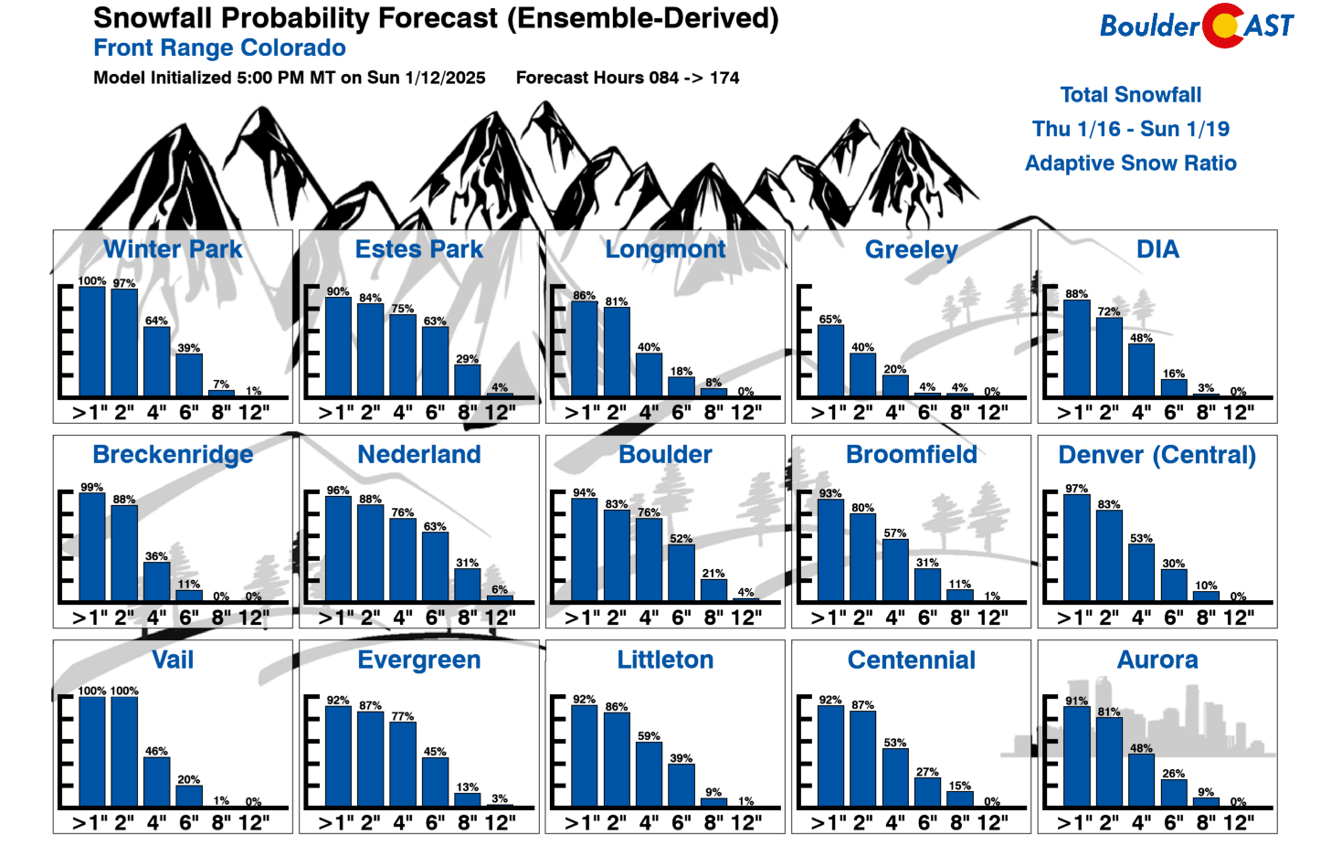
Our latest Snowfall Probabilities are clearly on-board for the widespread snow accompanying the Arctic air’s arrival late Friday into Saturday (see below). For now, plan on 3 to 7 inches of fluffy snow falling Friday evening into Saturday, with higher totals possible in Boulder and the Foothills — perhaps 5 to 11 inches?
This is definitely still an evolving forecast at this point, but here’s the general summary of where things stand now:
Arctic Blast: What we know right now:
- An Arctic cold front will arrive later in the day Friday into the Denver area, likely during the afternoon or early evening hours.
- Behind the front, the coldest air of the season so far will settle in and linger through at least Monday night.
- Widespread fluffy snow will follow behind the Arctic front Friday evening into early Saturday causing slick roads and travel impacts region-wide. Several inches of accumulation are highly likely. Probable snowfall totals are in excess of 4″ for the entire area, with 6″+ in Boulder and the Foothills.
Arctic Blast: What is still being ironed out:
- The exact timing of the Arctic front. If it comes in a bit earlier, we could see snowy impacts for the Friday evening commute.
- Snowfall amounts Friday into Saturday, and whether an additional round of light snow will follow later on Sunday into Monday.
- Exactly how cold it will get this weekend. Several nights of below zero temperatures are likely, with some chance for even daytime highs below zero one or two days!
- When and how quickly we will dig out from the Arctic air next week — Tuesday seems to be the day where things start to turn around, but Arctic air is dense and often stubborn to vacate around these parts.
That’s all we have to discuss for now. We’ll continue to monitor the situation and provide daily updates through the week via our morning Premium discussions. However, everyone will be hearing from us later in the week as the Arctic air and accompanying snow draw nearer. Be sure to follow us on Twitter, Facebook, Bluesky and Threads for additional updates this week and into the future. Enjoy the quiet weather through Thursday — this week will certainly end with a 💥!
Forecast Specifics:
Monday: Mostly sunny and cool. High temperatures in the upper 30s on the Plains with middle 20s in the Foothills.
Tuesday: A few clouds, but otherwise quiet and cool. Temperatures will reach the upper 30s on the Plains with upper 20s in the Foothills.
Wednesday: Lots of sunshine and slightly warmer. Highs reach the middle 40s on the Plains with lower 30s in the Foothills.
Thursday: Sunny and notably warmer with temperatures topping out in the middle 50s on the Plains with lower 40s in the Foothills.
Friday: Mild early in the day with sunshine, but increasing clouds and a blast of Arctic air arriving in the afternoon to early evening. Temperatures should top out in the 40s early on, but drop like a rock behind the front quickly into the teens with widespread snow developing. Several inches of accumulation are likely Friday evening into Saturday.
Weekend: Bitter cold air will be entrenched across northeast Colorado all weekend long, with high temperatures below 15°F Saturday and likely below 10°F on Sunday. Overnight lows will drop below zero. Light snow will taper off by Saturday afternoon, but additional snow may follow late Sunday or Sunday night.
Get BoulderCAST updates delivered to your inbox:
DISCLAIMER: This weekly outlook forecast is created Monday morning and covers the entire upcoming week. Accuracy will decrease as the week progresses as this post is NOT updated. To receive daily updated forecasts from our team, among many other perks, subscribe to BoulderCAST Premium.
Daily Forecast Updates
Get our daily forecast discussion every morning delivered to your inbox.
All Our Model Data
Access to all our Colorado-centric high-resolution weather model graphics. Seriously — every one!
Ski & Hiking Forecasts
6-day forecasts for all the Colorado ski resorts, plus more than 120 hiking trails, including every 14er.
Smoke Forecasts
Wildfire smoke concentration predictions up to 72 hours into the future.
Exclusive Content
Weekend outlooks every Thursday, bonus storm updates, historical data and much more!
No Advertisements
Enjoy ad-free viewing on the entire site.
Enjoy our content? Give it a share!





You must be logged in to post a comment.