Get ready, Colorado! A major winter storm is on the horizon, promising to blanket the Mountains with up to 30 inches of snow and transform ski resorts into powder paradises. But that’s not all—rain will turn to snow in the Denver Metro area Tuesday night, potentially disrupting the Wednesday morning commute. Curious about the full forecast and how it might impact your Thanksgiving plans? Read on as we discuss the timing of the change-over to snow, the expected snowfall totals for everyone and when travel may be most impacted.
At a Glance:
- Weather Overview: A deep pipeline of Pacific moisture is flowing into Colorado already with a slew of weather impacts expected now through Wednesday night!
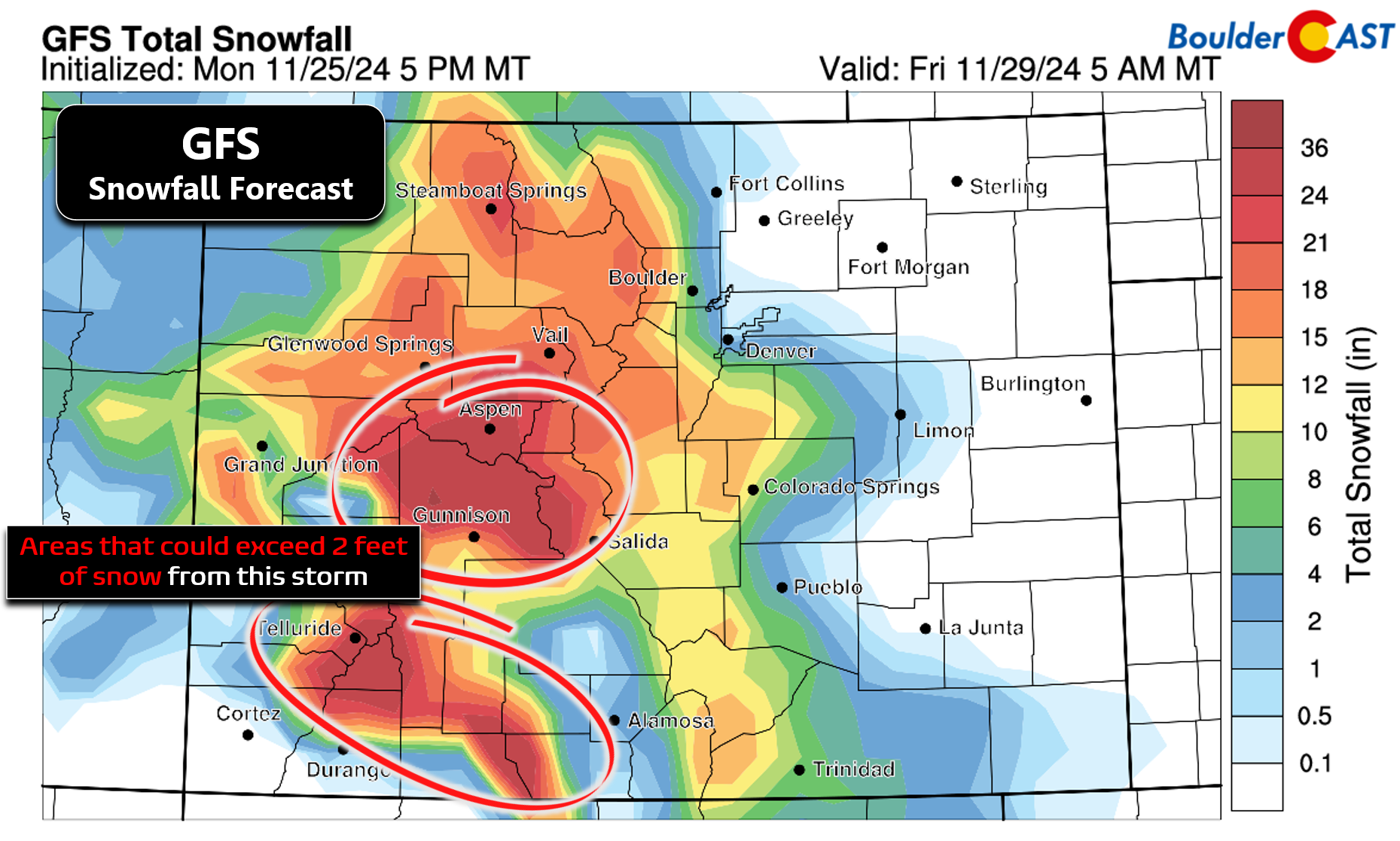
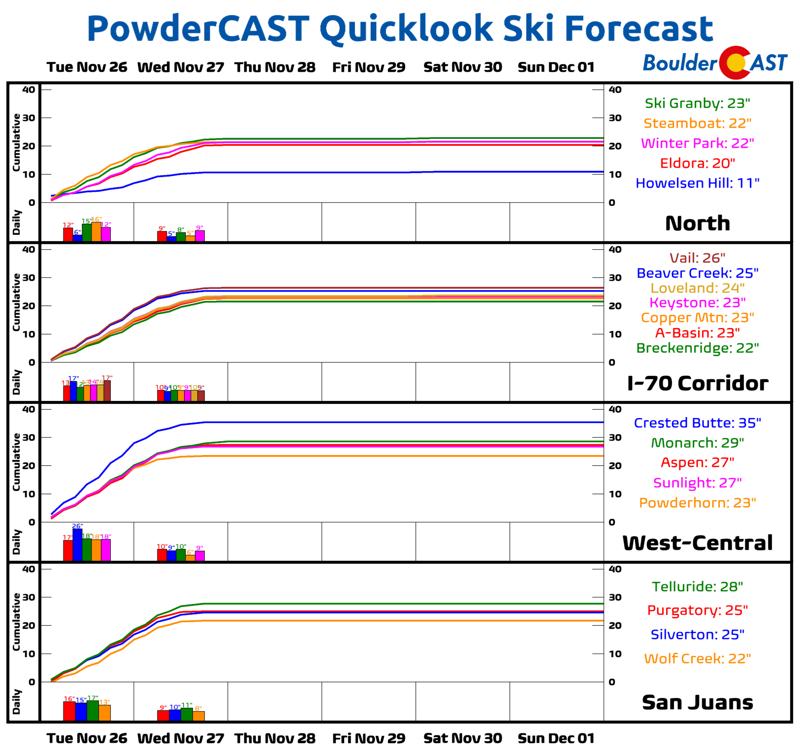
- Skiers Rejoice! The Mountains will experience continuous snowfall for about 36 hours, with totals ranging from 10 to 25 inches above 10,000 feet, and locally over 30 inches in southwest Colorado.
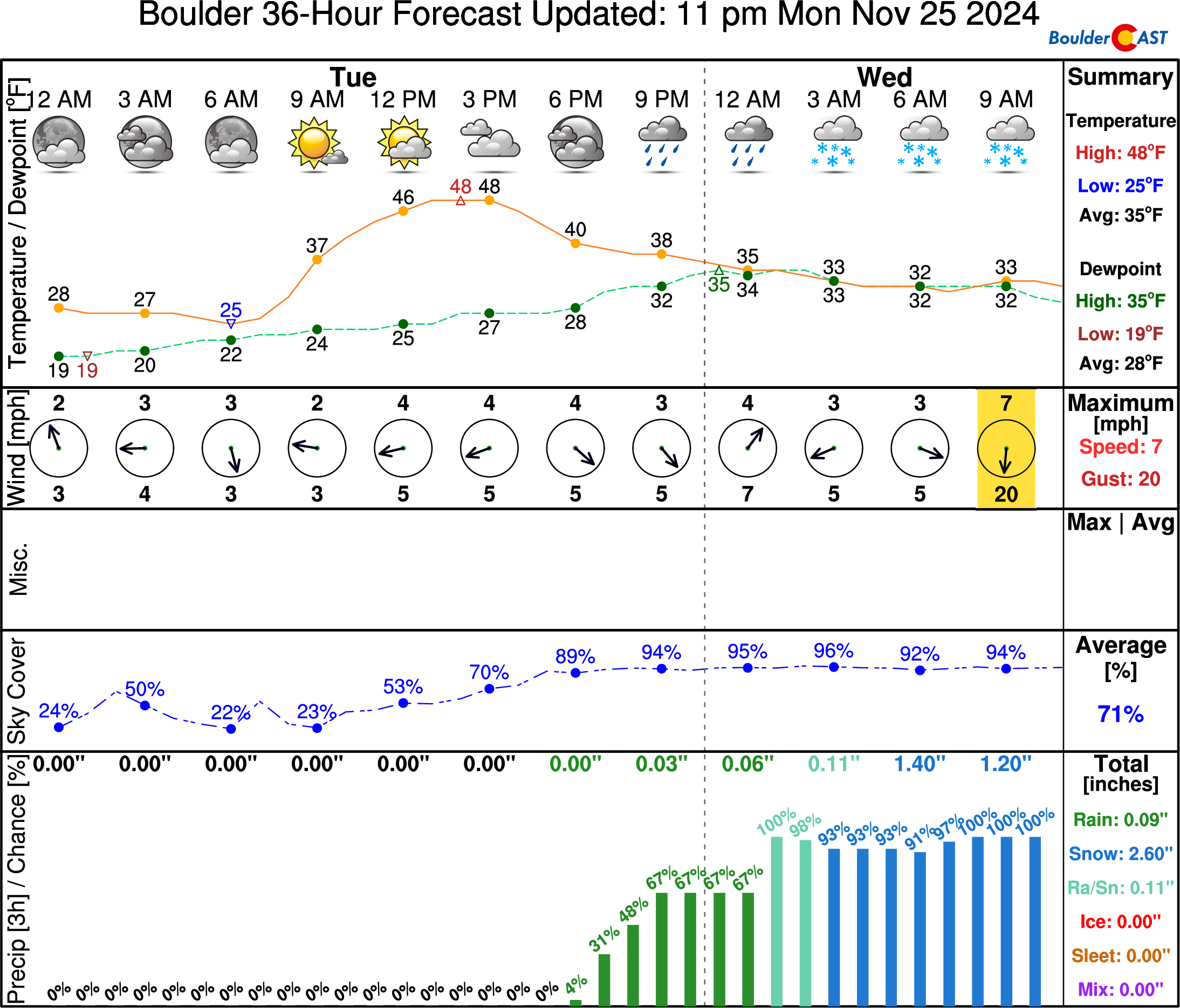
- Lower Elevations: The lower elevations will see rain changing to snow Tuesday night into Wednesday morning, with 1 to 4 inches of snow expected in the Denver area and 3 to 6 inches in Boulder.
- Travel Impact: Difficult travel conditions are a certainty in the Mountains, with road closures likely, especially over mountain passes. Enhanced snowfall during the Wednesday morning commute could create travel disruptions in the Metro area, but overall impacts across the lower elevations are expected to be relatively minor due to warm road and air temperatures.
- A Sunny Turkey Day: Snow will come to an end late Wednesday with skies clearing out. Though it will be chilly, Thanksgiving Day will be sunny, dry and quiet in the Front Range.
Daily Forecast Updates
Get our daily forecast discussion every morning delivered to your inbox.
All Our Model Data
Access to all our Colorado-centric high-resolution weather model graphics. Seriously — every one!
Ski & Hiking Forecasts
6-day forecasts for all the Colorado ski resorts, plus more than 120 hiking trails, including every 14er.
Smoke Forecasts
Wildfire smoke concentration predictions up to 72 hours into the future.
Exclusive Content
Weekend outlooks every Thursday, bonus storm updates, historical data and much more!
No Advertisements
Enjoy ad-free viewing on the entire site.
Snow returns leading up to Thanksgiving!
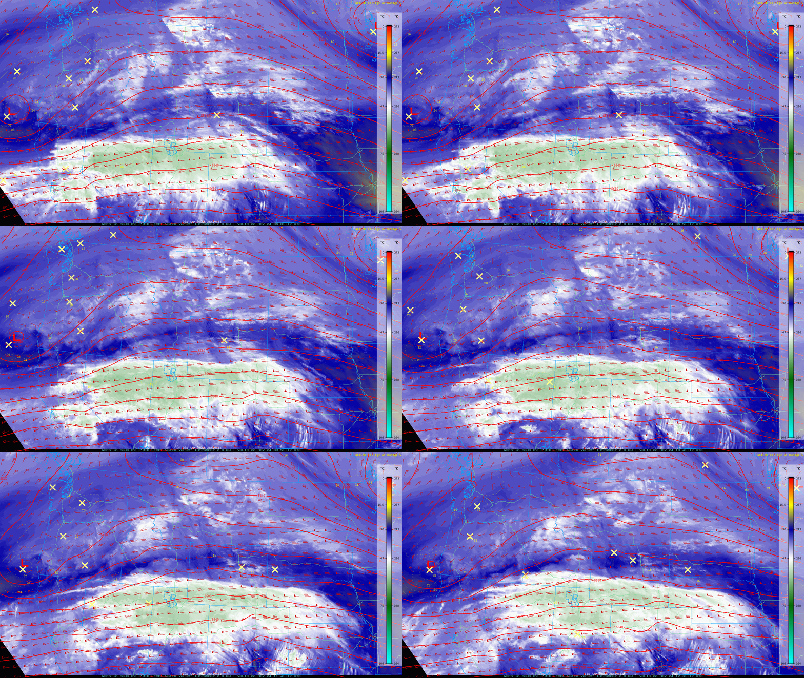
The anticipated deep pipeline of Pacific moisture, compliments of a remnant atmospheric river, is already flowing into Colorado early Tuesday morning with light to moderate snow beginning to spread into the Mountains. Check out the narrow plume of mid-level moisture advecting in across the area in the GOES-East water vapor animation below from early Tuesday. Amazingly, the primary trough and storm system are still offshore of Oregon right now. Everything unfolding today in the Mountains is simply the result of near-record levels of atmospheric moisture slamming into the terrain from the west.
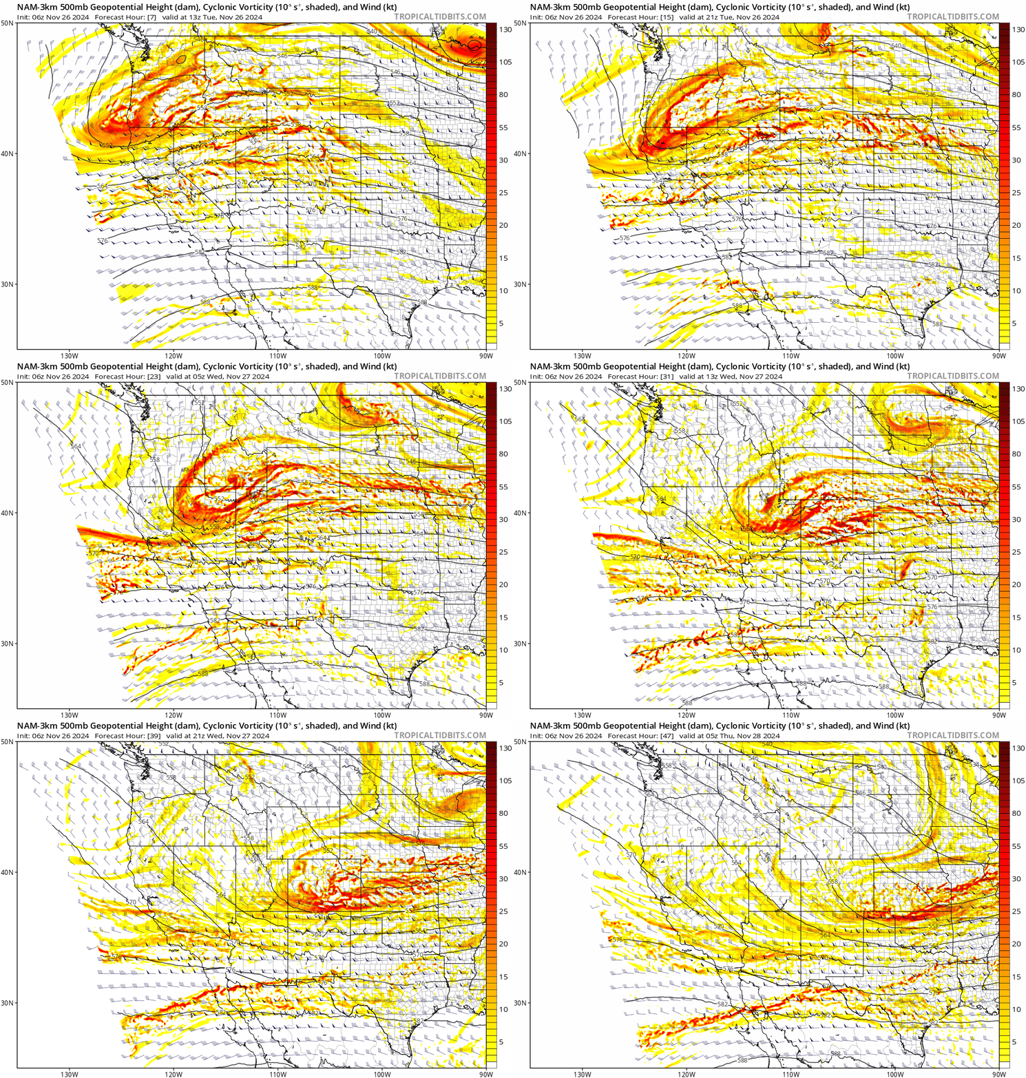
The main trough will be marching eastward over the next 36 hours, moving through Nevada Tuesday night and eventually across Colorado Wednesday morning.
Until this trough axis passes late on Wednesday, the Mountains will be under the gun from moist orographic flow the entire time with near continuous light to moderate snowfall adding up to significant totals over time. The widespread Mountain snow is the most certain aspect of the forecast as this system moves through — temperatures are plenty cold up there, there’s heaps of moisture flowing in, and the long duration of west-southwest flow will provide decent, prolonged orographic lift for all mountain ranges. There will also be periods of instability, jet forcing and frontal lift which could enhance snowfall rates up to 1-2″ per hour at times Tuesday evening and night. For the most part, though, this will be a light to moderate snowfall event in the Mountains but one that lasts some ~36 hours.
Mountain snowfall totals above 10,000 feet along and west of the Divide will range from 10 to 25 inches by Wednesday evening, with locally over 30 inches possible in the most favored slopes of southwest Colorado between Aspen, Crested Butte, Telluride and Durango. This will create very difficult travel the next couple days with road closures almost a certainty, especially over mountain passes. You may want to consider postponing any travel up there until things start to die down Wednesday evening or night.
Skiers will certainly have plenty of snow to flock to this week, no matter the slopes of choice. PowderCAST is predicting more than 20″ of snow for nearly ever ski resort in the state! As mentioned, you may have a difficult time traveling to many of these resorts if you aren’t already there. Otherwise, with quiet conditions expected for Thursday, it would be a wiser idea to plan to ski on Thanksgiving Day or Friday.
Across the lower elevations, the forecast is not as certain, nor as easy. The copious moisture flowing up over the Continental Divide and eastward into the Front Range will produce a lot of cloud cover Tuesday, but not much in the way of precipitation as the low levels remain quite dry and downslope flow is rampant. Our temperatures will warm up close to 50 degrees during the day with mostly dry conditions. There could be some spillover snow in the highest Foothills during the day Tuesday with light accumulations about 9000 feet. However, most of us won’t see precipitation begin until Tuesday evening.
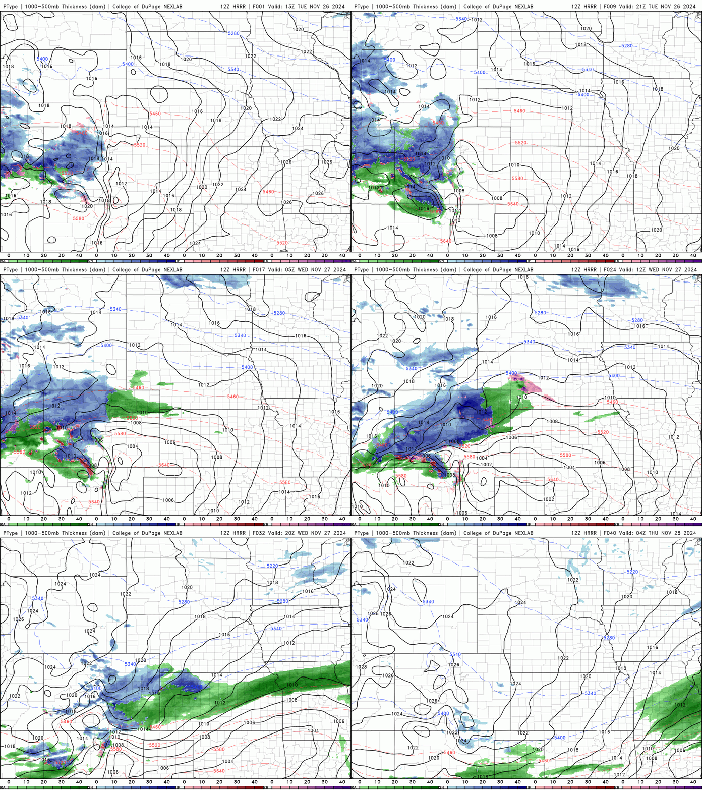
Even though we are nearly in December, this is a definitely Pacific-sourced storm system with the supply of cold air fairly limited, at least initially until the main trough catches up to the deep moisture plume. Snow levels will initially be quite high. As precipitation begins Tuesday evening, snow levels will be around 8000 feet, falling towards 6000 feet by midnight and dropping below 5000 feet sometime during the wee morning hours Wednesday. Rain showers should change-over to snow for everyone between Midnight Tuesday night and sunrise Wednesday, with the bulk of the accumulation across the Boulder-Denver area occurring during the morning hours into midday — largely centered on the AM commute window!
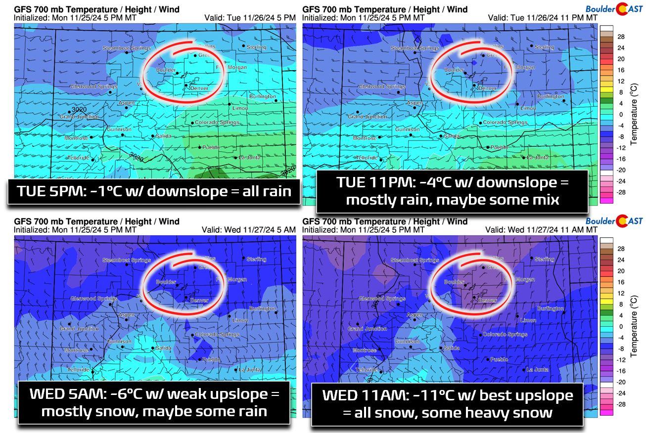
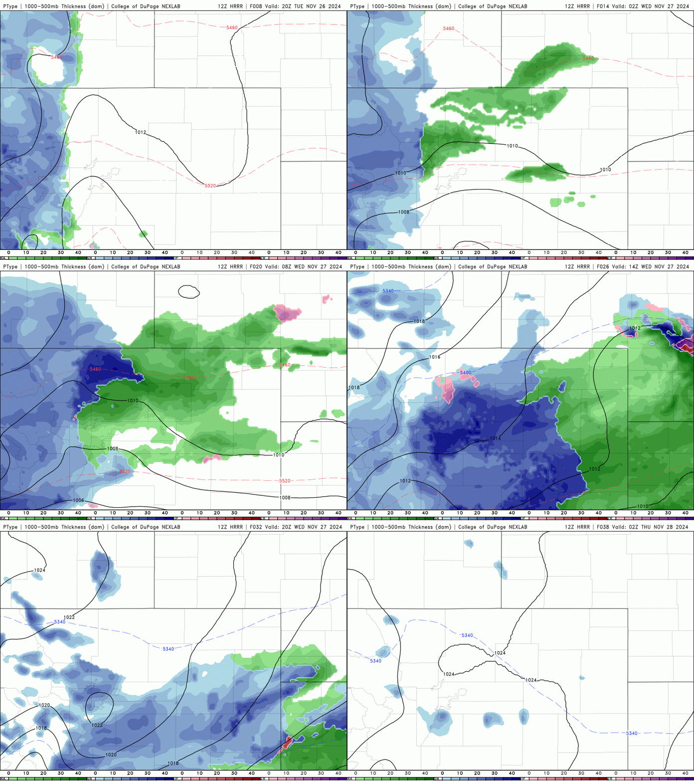
Column temperatures will be warm initially, but will plummet as the primary mid-level cold front arrives late Tuesday evening. The four-panel graphic below shows temperatures and winds at 10,000 feet elevation Tuesday night into Wednesday — this can help us gauge what temperatures aloft will be and how the wind fields may unfold. Basically, we see that this event will surely begin as liquid precipitation across the lower elevations as temperatures of -1 to -4°C will support rain in the Denver Metro area. As we cool further after midnight, rain will change over to snow for everyone as temperatures aloft tumble to -11°C by mid-morning Wednesday.
Sometimes when we have a system like this transitioning from rain to snow, the best forcing can occur in the warmer half of the event with lesser lift for precipitation after the change-over to snow— this can limit snowfall potential with much of the precipitation being “lost” to rain. That doesn’t really appear to be the case with this impending storm. We’re now also seeing pretty good model agreement for a burst of deeper and moderately strong upslope flow Wednesday morning from the northeast (above, bottom right panel), which may also overlap with a period of jet forcing. Thus, we should see a several hour period Wednesday morning where moderate to heavy snow falls across some of the area with up to 1″ per hour snowfall rates.
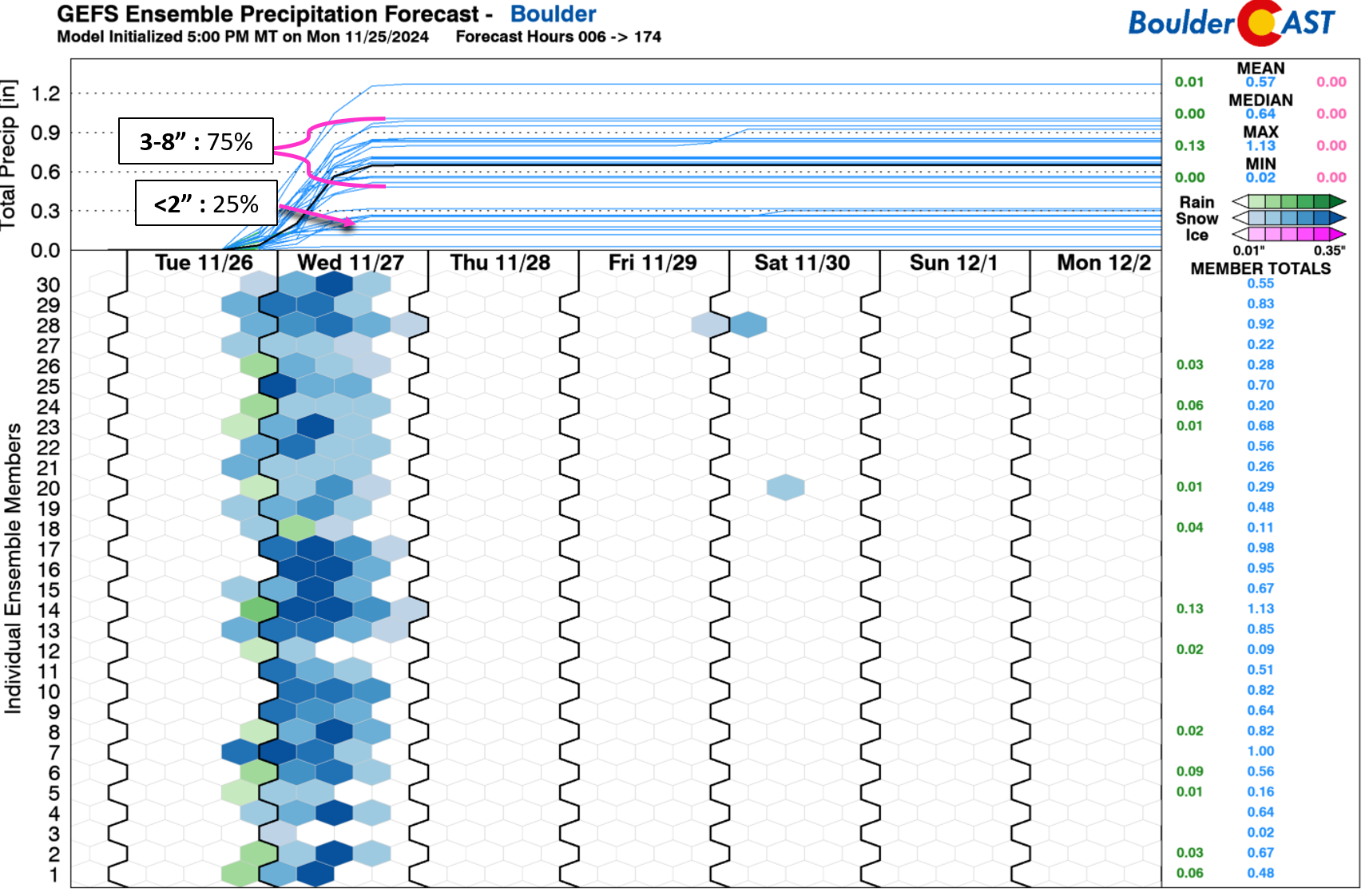
Global guidance has remained fairly consistent with this event over the last day or two, and now short-range models are coming in similar as well. In general we’re expecting about 0.4 to 0.9 of precipitation to fall in Boulder, with closer to half that amount in Denver. The latest ensembles indicate a bimodal distribution of precipitation for Boulder. The most likely outcome produces 3-8″ of snow in the city (75% of ensemble members), but there is a separate common outcome for <2″ of snow (25% of members). For now our forecast will lean towards the more likely, higher-end outcome. This is also supported by most other model guidance.
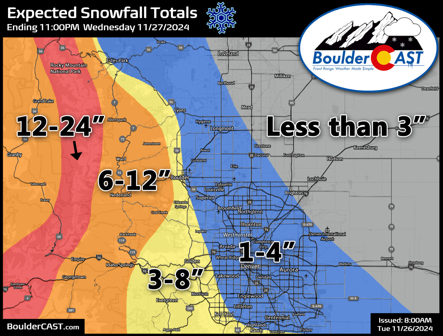
Our snowfall forecast map for this event is shown below covering all snow falling through Wednesday evening. As mentioned, most of the accumulation across the lower elevations will occur Wednesday morning. We are expecting a broad brush of 1-4″ of snow in most of the Denver area, with 3-6″ in Boulder, and 4-12″ in the Foothills — highest in Boulder County above 7500 feet. The Continental Divide will be blanketed by 1 to 2 feet by the time snow ends late Wednesday — this includes all the major passes such as Eisenhower Tunnel, Berthoud Pass, and Loveland Pass. Plan your travel accordingly!
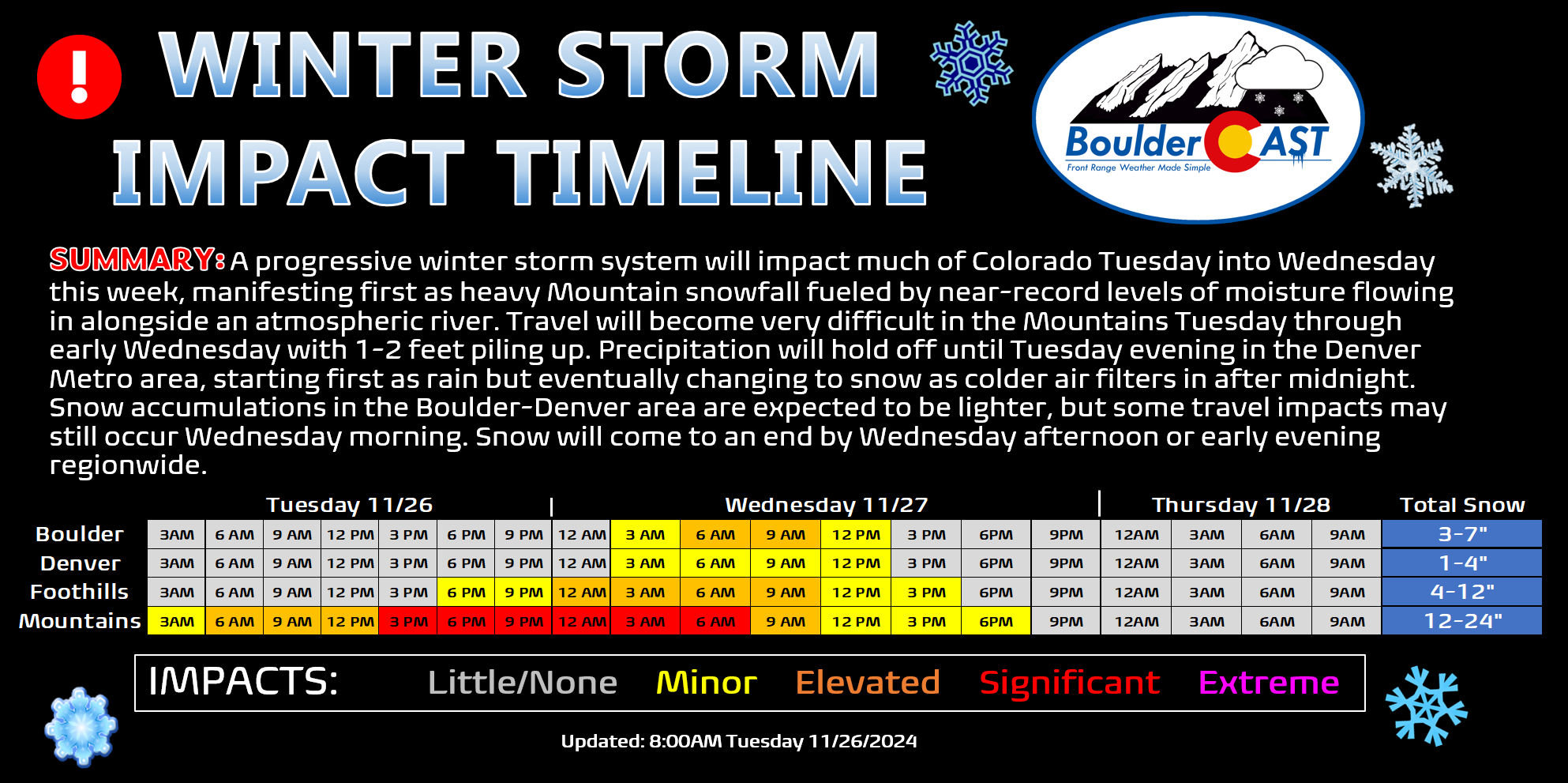
Speaking of travel impacts, most of the trouble with this storm will be found across the higher terrain with significant impacts expected in the Mountains with likely road closures at times. Across the Denver Metro area, generally only minor travel impacts are in the cards due to the warm road and air temperatures, only dropping slightly below freezing by Wednesday morning. There is the risk for embedded bands of heavier snow during the Wednesday morning commute which could create areas of worsened impacts early Wednesday, but in general travel should be mostly okay but leave a little extra time.
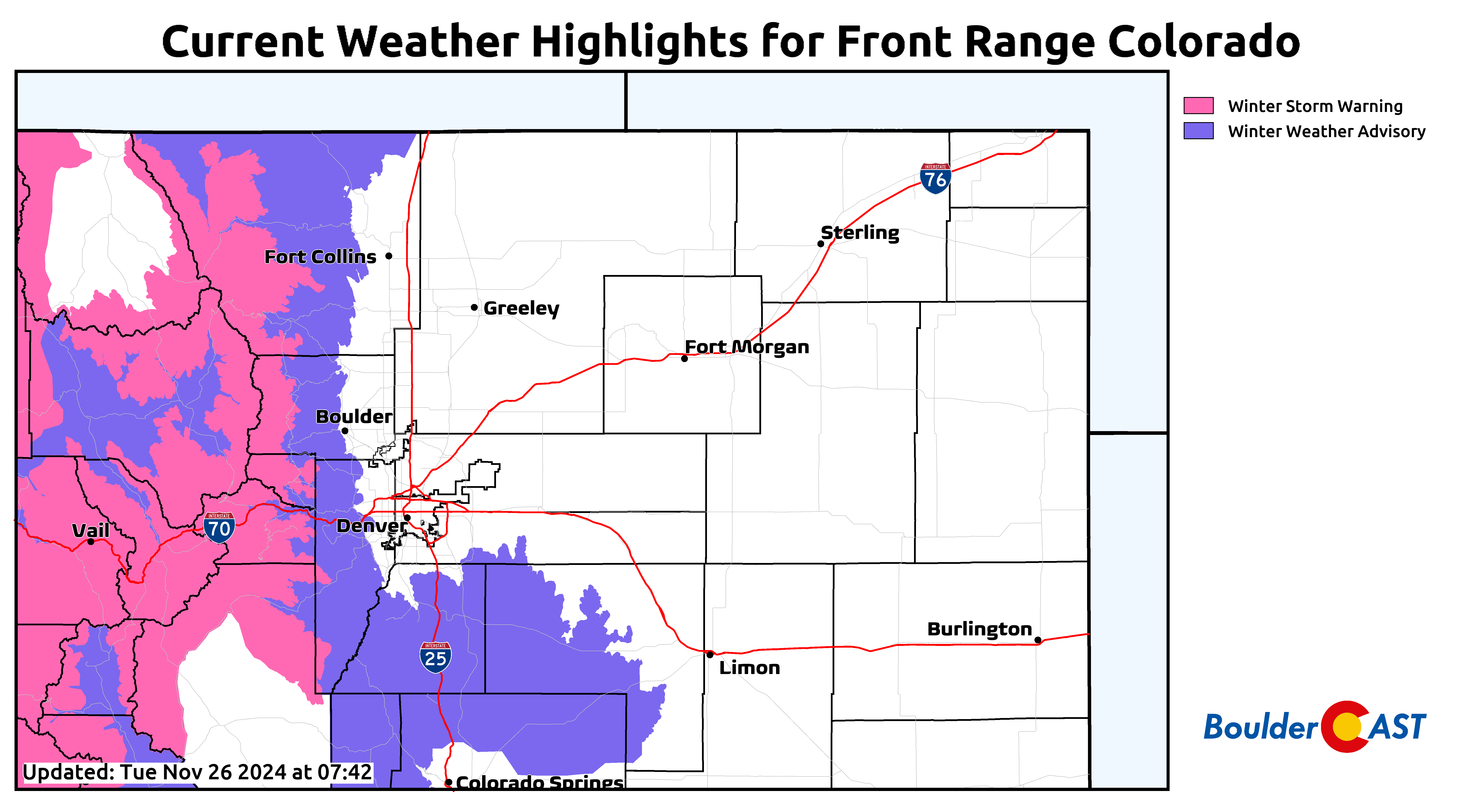
As of writing Tuesday morning, Winter Storm Warnings are issued for the Mountains where travel will become very treacherous. Winter Weather Advisories are posted for the Foothills and Palmer Divide which will be mostly snow, after a brief window of rain at the onset. Given the potential impacts to the morning commute on Wednesday, it wouldn’t be surprising at all to see Advisories soon expand to include Boulder and Golden, and possibly Denver as well.
We conclude with breakdown of the storm timeline:
- Tuesday: Partly to mostly cloudy but dry as high temperatures climb to near 50 degrees across the lower elevations. Light to moderate snow will be ongoing through the Mountains during the day, with some spillover into the higher Foothills and light accumulations.
- Tuesday night: Rain and Foothills snow will spread into the area through the evening with snow levels coming down slowly. Rain will change to snow across the lower elevations after midnight but before sunrise Wednesday. 3-6″ are expected by sunrise in the Foothills, with just an inch or two at best on the lower elevations.
- Wednesday: Snow will be widespread across the area in the morning, with some pockets of moderate to heavy snow possible. Snow will begin to taper off during the afternoon, lingering longest in the southern and southwest Metro area and Foothills. 1-4″ of additional snow may fall during the morning on the Plains, with 3-7″ in the Foothills.
- Wednesday night: Any lingering snow should taper off quickly leaving behind cold temperatures in the teens on the Plains with single digits in the Foothills as skies clear out.
- Thanksgiving Day: Beautiful and sunny with highs around 40 degrees.
- Friday: More sun and a bit warmer in the 40s.
We’ll pass along timely updates on social media as needed and via an additional Premium Storm Update tonight or Wednesday morning. Be sure to follow us on Twitter, Facebook, Bluesky and Threads for impromptu weather updates as the storm unfolds, or subscribe to get notified of our long-form updates here. That’s all we have for now. Let it snow!
Get BoulderCAST updates delivered to your inbox:





You must be logged in to post a comment.