After already delivering a thick blanket of snowfall earlier in the week, the very same storm system is set to boomerang back north and slam eastern Colorado once again with widespread precipitation Friday into Saturday. With temperatures not as cold as last time, the storm’s impact will vary across the region, with plenty of heavy snow to go around, but also unfortunately with chilly rain spoiling the party a bit for northern cities. We discuss expected snowfall amounts, potential travel impacts, and the unique meteorological conditions contributing to what will be an extreme event for some parts of eastern Colorado to end the week.
Premium Storm Update (11/9/24 9:00 AM): The faucet of Gulf of Mexico moisture is on full blast into Colorado today! Moderate to heavy snow is beginning across the Front Range NOW and will continue through early Saturday, at times mixing with rain on the north side. We discuss the latest on the approaching low pressure, take a tour through the most recent model data, and provide a few final details leading into this big and wet snowstorm! READ HERE
At a Glance
- Wait, This is the Same Storm? After dropping up to a foot of snow in the Denver Metro area Tuesday night, the very same storm will yo-yo back northward into eastern Colorado bringing another round of heavy snowfall beginning late Friday morning.
- Why You Gotta Be So Warm? Unlike the last event, temperatures will be near or above freezing much of the time Friday in the northern Metro area leading to rain or a rain/snow mix north of Boulder. Areas further south through Denver are expected to see all snow, or close to it. The Foothills will be all snow as well, and with higher snow ratios.
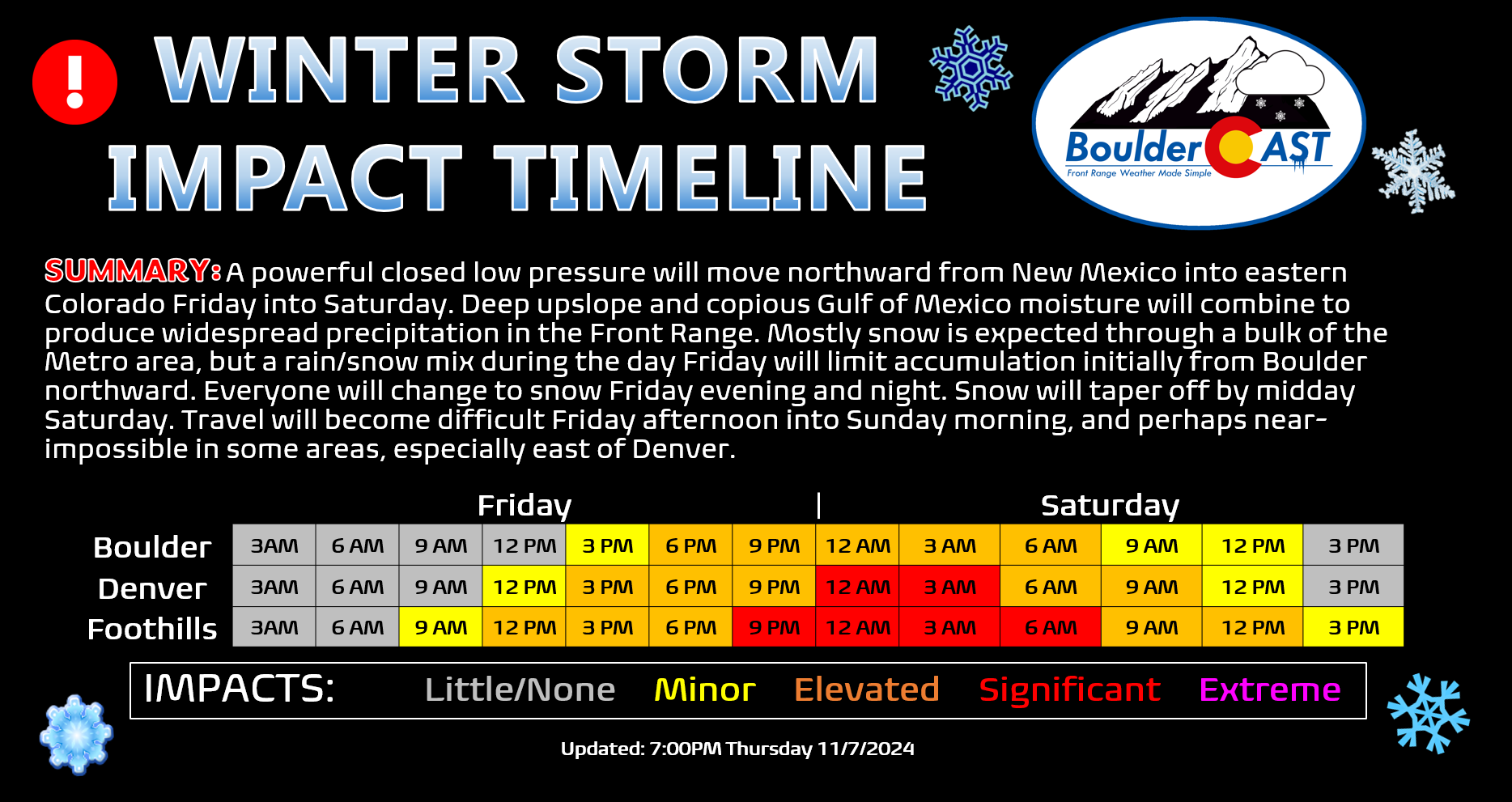
- Timing: Precipitation will begin Friday late morning and continue into Friday night, tapering off early Saturday. Areas that see rain/snow mix during the day Friday should transition to all snow Friday evening.
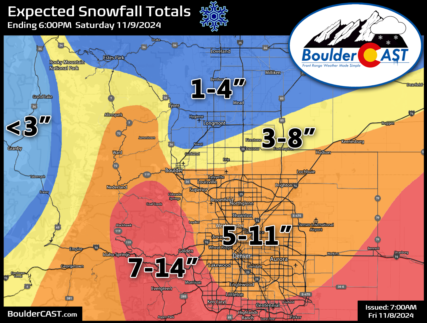
- Snowfall Amounts: 5-11″ are expected for much of the Denver Metro area, with 4-10″ in Boulder (very temperature dependent) and 1-6″ for areas further north. Up to 14″ may fall in the southern Foothills and southeast of Denver.
- Travel Impacts: Travel will become difficult across the Denver area Friday afternoon and especially into the evening and nighttime. Airport travel will likely be impacted with delays and cancellations. Travel east towards Kansas may become near-impossible due to heavy snow and blowing snow.
Daily Forecast Updates
Get our daily forecast discussion every morning delivered to your inbox.
All Our Model Data
Access to all our Colorado-centric high-resolution weather model graphics. Seriously — every one!
Ski & Hiking Forecasts
6-day forecasts for all the Colorado ski resorts, plus more than 120 hiking trails, including every 14er.
Smoke Forecasts
Wildfire smoke concentration predictions up to 72 hours into the future.
Exclusive Content
Weekend outlooks every Thursday, bonus storm updates, historical data and much more!
No Advertisements
Enjoy ad-free viewing on the entire site.
One final blast of snow this week, and it’ll be a doozy!
We first alerted you to just how wintry this week could end up being for the Front Range about one week ago when a few models started showing the potential for BIG snow in the distant forecast compliments of, not one, but two cut-off low pressure systems. On the highest end, the trusty European model was predicting widespread totals of 1 to 3 feet of snow for almost all of Colorado, with the bullseye landing across the Palmer Divide area.
We've mostly dodged winter weather so far in the Boulder/Denver area, but that will change next week as cold air settles in along with two potential cut-off low pressure systems. The latest Euro run is a bit excited…dumping 1-2 feet across our area in total. Still a lot of… pic.twitter.com/CaSfwVXPit
— BoulderCAST Weather 🏔️❄️ (@BoulderCAST) November 1, 2024
A week later, we’ve largely seen this snow lover’s dream forecast somehow come to fruition with Mother Nature absolutely pummeling Colorado (and New Mexico, to be fair) with borderline historic precipitation and snowfall totals totals already — and she’s not done yet!. The first cut-off low delivered a round of decent rain (and some wet snowflakes) Sunday night into Monday. This is the storm that technically ended our 10th Annual First Snowfall Contest in Boulder, as the slightly higher elevation neighborhoods of Boulder picked up a brief slushy accumulation on the grass.
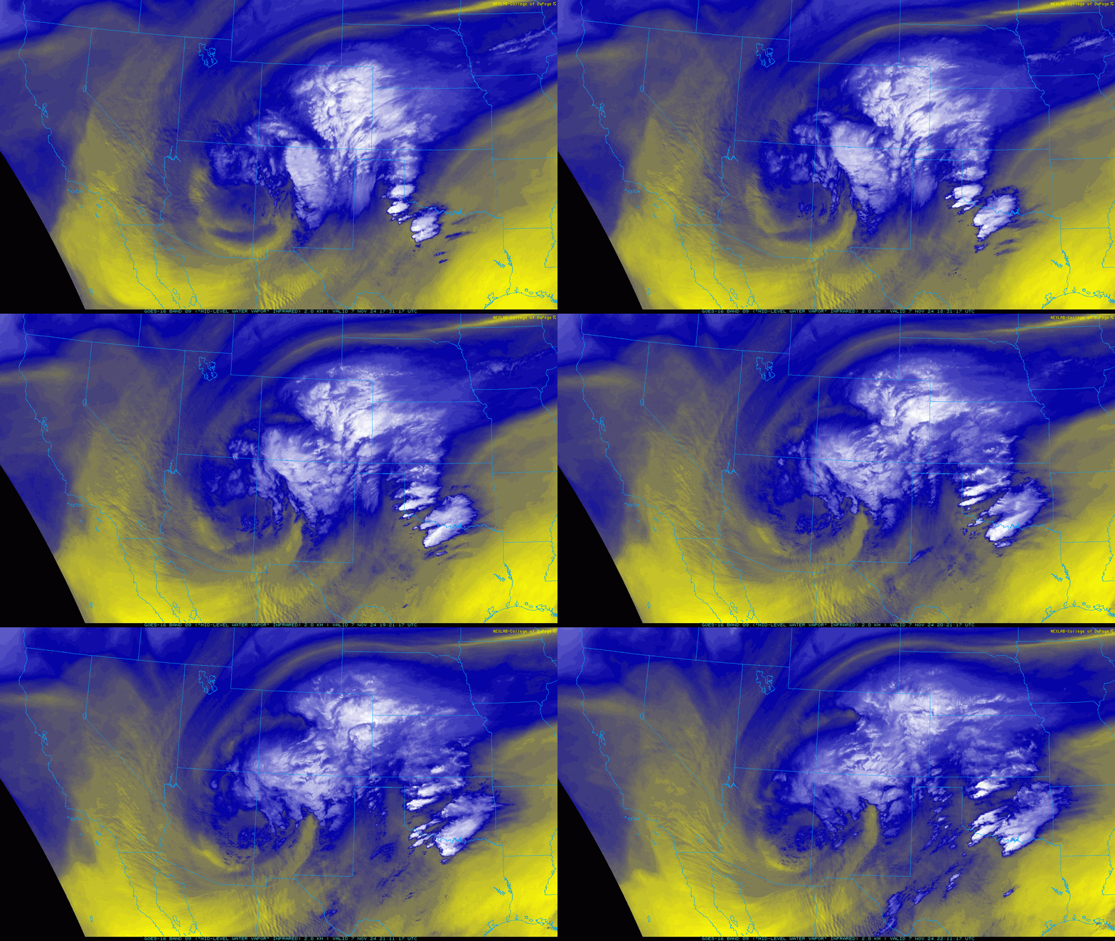
While many of you were left wanting a more rousing start to the snow season than just a few flakes, less than two days later the second cut-off low would deliver just that Tuesday night into Wednesday. The unique track of the storm initially had the models and forecasters alike confused and overall unimpressed with the situation. However, just before the flakes started flying Tuesday evening, nearly every single model started to take a sharp snowy turn as everything came together just a tad further north than expected. There were certainly some hints in the data to suggest this “boom” scenario could happen (about 10-20%, which we commented on in the days leading up), but things really came together at the last minute. You know the story from there — anywhere from 2 to 12″ of snow fell across the Denver Metro area on Wednesday as the big ol’ low pressure dove south through Utah on its way into Arizona, where it resides right now.
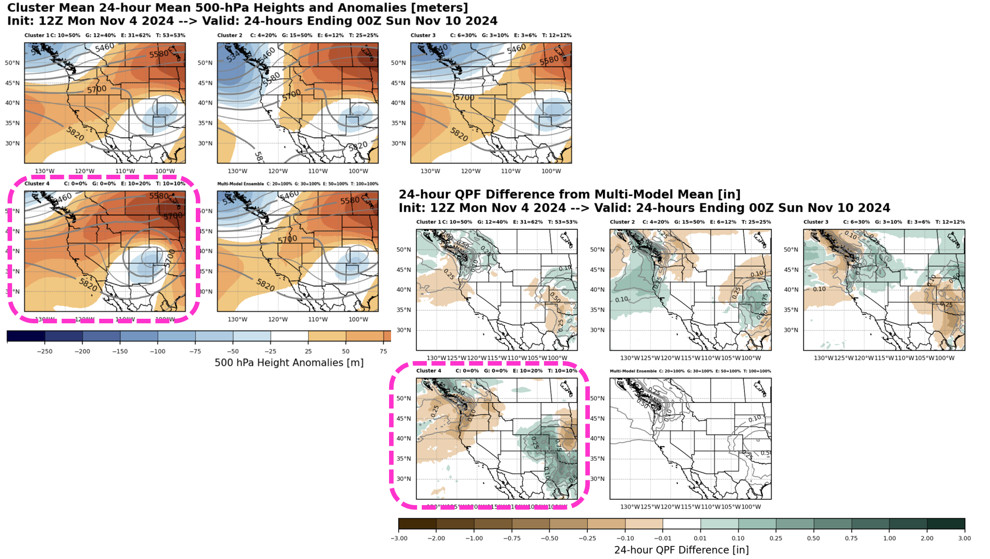
Interestingly, when we posted our weekly outlook discussion back on Sunday, our team was most excited about the final chance of snow for us set to unfold Friday into Saturday as the cut-off low pressure moved from Arizona into the Great Plains, boomeranging back north and passing through eastern Colorado in the process. This event looked the best on paper to us, one which could certainly deliver a classic upslope autumn storm for the Boulder-Denver area. In the days that followed, that late-week storm all but vaporized from the forecast. By Monday evening, the weather gods had changed their mind. The odds of seeing a substantial snowstorm on Friday in Denver fell to a measly 10% based on over 100 ensemble model runs. Only a small subset of model solutions were hanging onto hope, represented as Cluster #4 in the panels below:
Shockingly, as the week went on, our late-week snowstorm re-emerged from the bowels of the supercomputers as the track of the low pressure was now forecast to take it directly into the sweet spot for the Denver area snow. Even better, it would be a slow-mover with a prolonged period of moderate to heavy snowfall targeting essentially all of eastern Colorado. That’s where we pick up the forecast now…
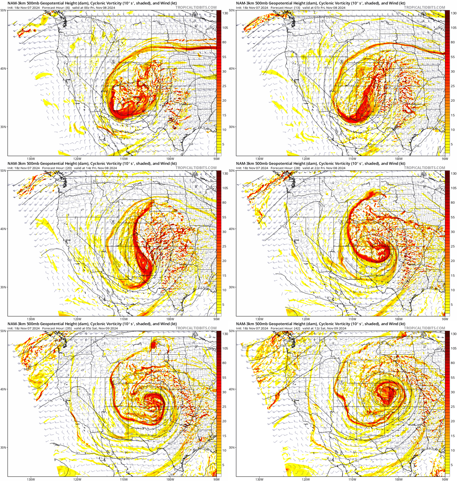
As we showed earlier, our anticipated low pressure system is currently spinning across southeast Arizona. Over the next 36 hours, this low pressure will slowly pivot while it moves into eastern Colorado by Saturday morning. The forecast animation at 500mb below really shows a unique evolution of the low, as it first pinches into a north-south oriented oval on Friday before strengthening into a tighter, concentric low over eastern Colorado early Saturday.
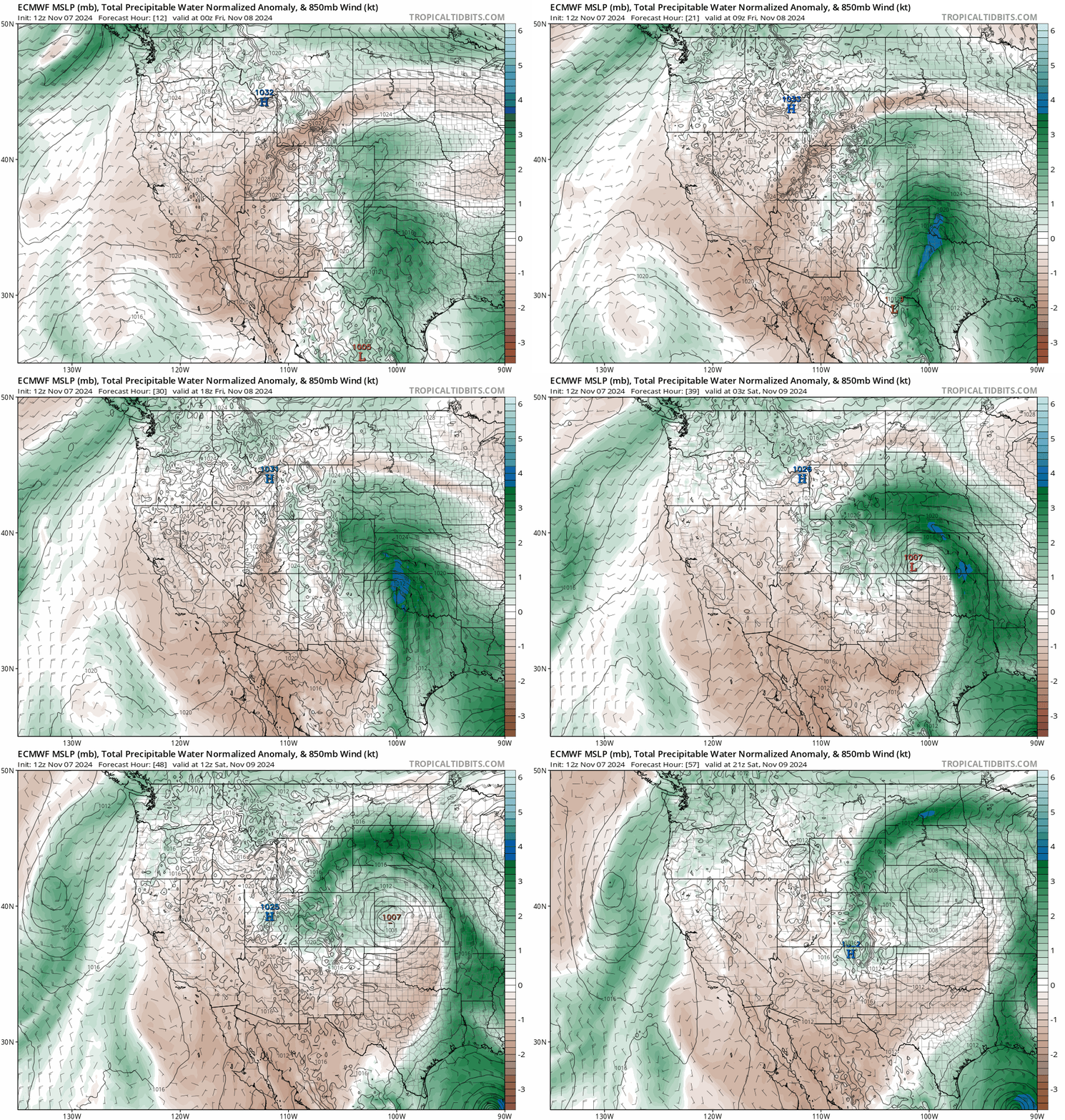
This north-south flattening of the low pressure will allow for exceptional meridional moisture transport straight northward from the Gulf of Mexico into eastern Colorado. Just look at all that juice:
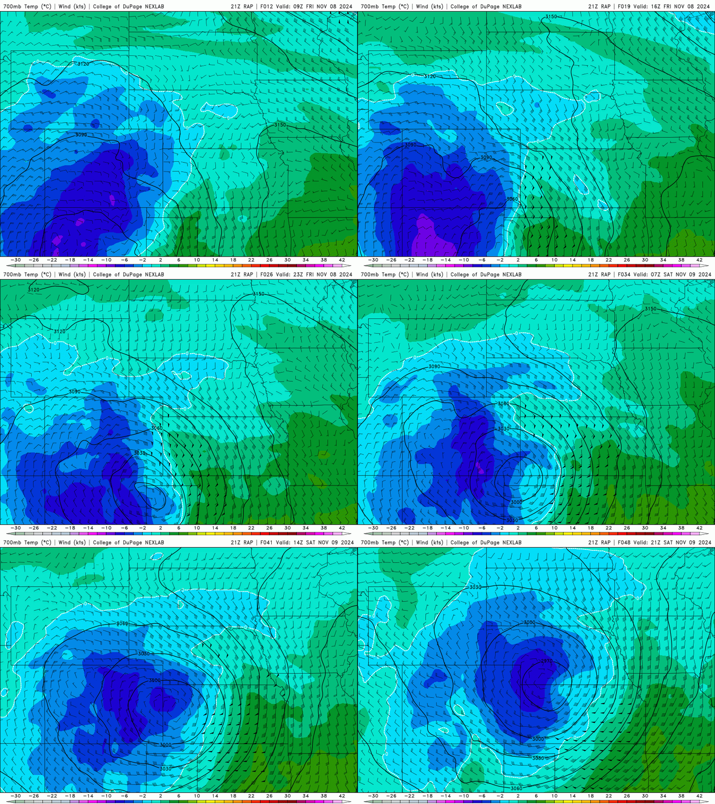
At the same time, a long-lived period of deep upslope flow will develop east of the Mountains, even well out ahead of the approaching low. The animation below shows temperatures and winds at the 10,000-foot elevation level. There’s a solid 18-hour period where deep upslope will be slamming into the terrain late Friday morning into late Friday night.
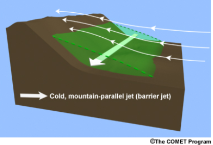
This situation seems like a prime candidate for a barrier jet to form in the Metro area. As a reminder, barrier jets develop when deep easterly flow is obstructed by the terrain for a prolonged period (3-5+ hours), causing low-level winds to turn towards the south near ground level. This mechanism forms a cold, dense “tube of air” near the base of the terrain which further enhances regional upslope motion. The tube of cold air essentially acts as an extension of the terrain eastward, allowing for heavy upslope precipitation to encompass the entire Front Range, even areas well away from the terrain. This could further enhance snowfall rates across much of the Denver Metro area, though it may end up hurting totals in and near the Foothills — including here in Boulder sadly.
Everything isn’t perfect for snow with this event though — we so wish it was! After spending a couple days down south in Arizona, the storm has moderated. It no longer possesses the bitter cold air it had when it first brought us that fluffy snow Tuesday night. This time around, temperatures will be warmer overall at the surface and aloft, especially once that warm and moist Gulf of Mexico air starts entraining into our area from the east and northeast. Cold air is often an issue for wandering, cut-off low pressure systems. By definition, they are cut-off or removed from the jet stream and cold air is usually north of said jet stream. Thus, due to the warmer temperatures, snow ratios will be lower (meaning wetter snow) and there will be more melting as temperatures will be near or just above freezing much of the day Friday as widespread precipitation falls. There will also even be some rain mixing in over the lower elevation areas from portions of northeast Boulder to Fort Collins where temperatures will be a couple degrees warmer (middle 30s). We also don’t love that some of the heaviest precipitation will be occurring during the daylight hours on Friday. Even through the clouds, the sun’s rays will cause increased melting.
Timeline & Precipitation Type Issues
After a lull in the action Thursday night, bands of precipitation will begin to spread northward into our forecast domain Friday morning, perhaps around sunrise to portions of the southern Metro area, a little later further north. Precipitation will be mostly snow at the onset from Denver southward, but it will be cold rain for areas north of Boulder (Longmont, Greeley, Loveland). As the ingredients all begin to meld together Friday morning into early afternoon, precipitation intensity and coverage will ramp up. This will mean heavy snow for places that are cold enough, with the warmer areas seeing rain/snow mix transition to snow occasionally in the heavier bursts. This will be a predominately snow event for many of us, but there will be lots of melting. Snow will be heavy at times during the day with rates of 1-2″ per hour possible during the afternoon and evening along and east of I-25, and in the Foothills.
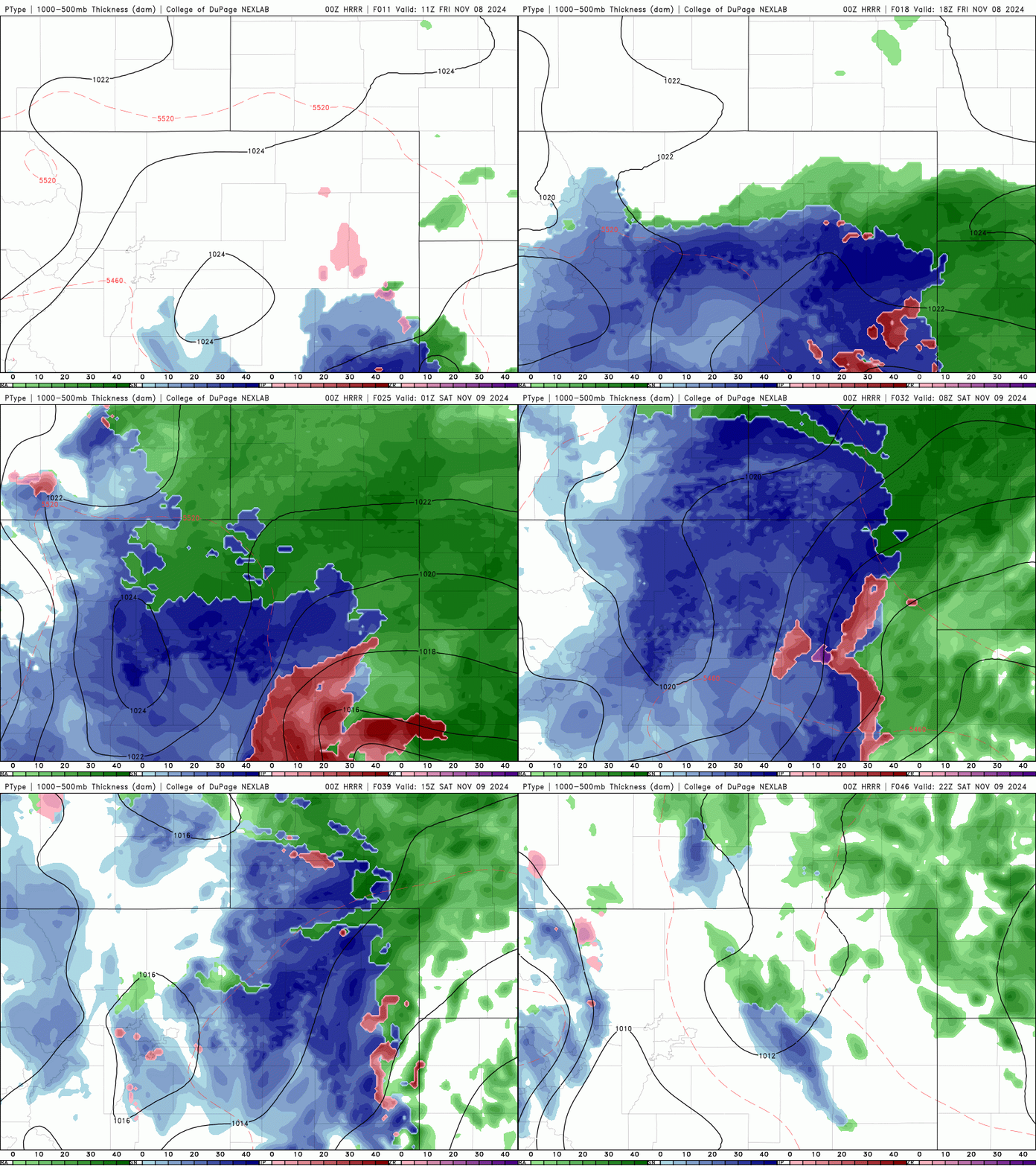
The far northern Metro area likely will remain as melty snow or rain/snow mix through much of the day with little accumulation. As the sun goes down Friday evening, temperatures will cool a tad allowing for everyone to shift fully over to snow with better accumulation rates. The far northern areas will take longest and may keep mixed precipitation into the late evening. Moderate to heavy snow should continue through at least midnight Friday night for much of the area. After that, upslope starts to weaken, with low and mid-level winds turning more northerly. This will begin to reduce precipitation intensity and shut down any barrier jet, with snow beginning to wind down Saturday morning as downslope starts to filter in from the northwest. Depending how long it lingers, the warmer areas may transition back to a tad of rain on Saturday at the tail-end of the event. The HRRR model simulated precipitation type forecast animation below highlights the most critical aspect of this particular storm — warm air leading to mixed precipitation from Boulder northward at times on Friday. As you already know, if it’s raining, it’s not snowing, and that will cut into potential snowfall totals.
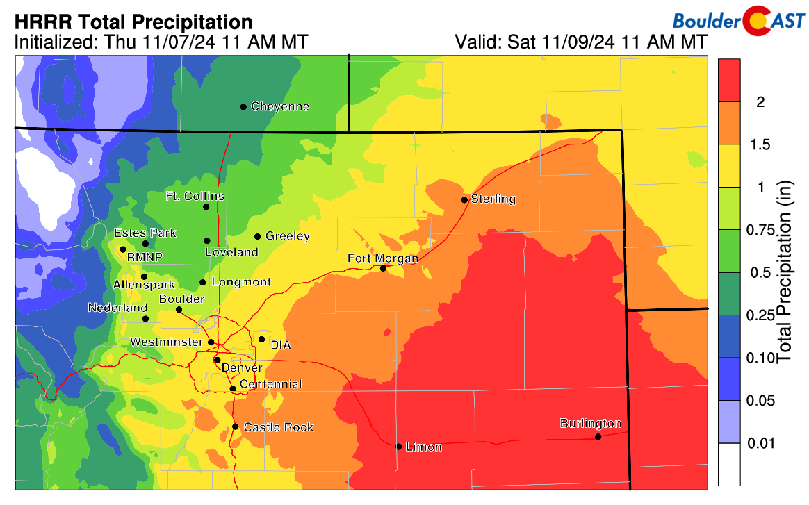
Most modeling agrees that our area will receive a hefty helping of moisture from this low pressure system as it passes by. In general, we’re looking at around 1″ of liquid falling from the sky Friday into Saturday, a bit higher south and east but lower north and west. Areas on the eastern Plains along I-70 could see 2-4″ of liquid equating to near historic snow totals in areas that don’t change over to rain (some will, at least part of the time). Plan for difficult to impossible travel out that way the next couple of days between DIA and the Kansas Border. Interstate 70 will almost certainly close for some time Friday into Friday night.
Snow Amounts
How much snow will we see from this storm? That’s always the million dollar question. With the intrusion of warm air in the northern Metro area for this event, snow totals will certainly be lower up there. However, further south and east, and in the Foothills above 6000 feet elevation, temperatures will be cold enough for snow the entire time leading to big totals. Our snowfall forecast map for this event is shown below. The trickiest part of this forecast is definitely what will happen between Boulder, Loveland, and Greeley where temperatures will be an issue. For now we’re going with 1-6″ from Gunbarrel to Loveland, with 4-10″ in most of Boulder and perhaps up to a foot in the higher elevation neighborhoods. Remember northerners, be patient if you’re not seeing much accumulation during the day Friday. Your turn will come Friday evening and night. For most of Denver, 5-11″ is in the forecast, though higher totals up to 14″ are possible on the colder, southern outskirts.
With this much snow falling in the very populated Front Range area, there’s bound to be travel impacts. Denver could start to see roadways trend downhill as early as late morning, getting worse Friday evening and night. Boulder will be warmer during the day and will only have limited impacts until late afternoon or evening. Due to considerably colder temperatures, plan for difficult travel in the Foothills beginning Friday late morning and well into Saturday, with roads quickly becoming snow-packed. It should be obvious, but any flights into and out of Denver after around midday Friday will be subject to cancellation or long delays.
Lingering Concerns & Things to Watch
- Temperatures: This is about as warm of a snow event as we’ll ever have in November here in the Front Range. We’ll be keeping an eye on observations and the modeling Friday morning to confirm that temperatures are on-track. Even a small 50-mile shift in the track of this huge storm system could drag the rain/snow line to new locations, north or south.
- Barrier Jet: It seems likely a barrier jet will form in the area, helping to intensify snowfall rates well east of the terrain up to 2 or even 3″ per hour. We’ll have to watch how this evolves Friday afternoon and evening. It could end up aiding in bonus snow for areas along and east of I-25, and in turn, lesser totals for areas in and near the Foothills.
Wrap-Up
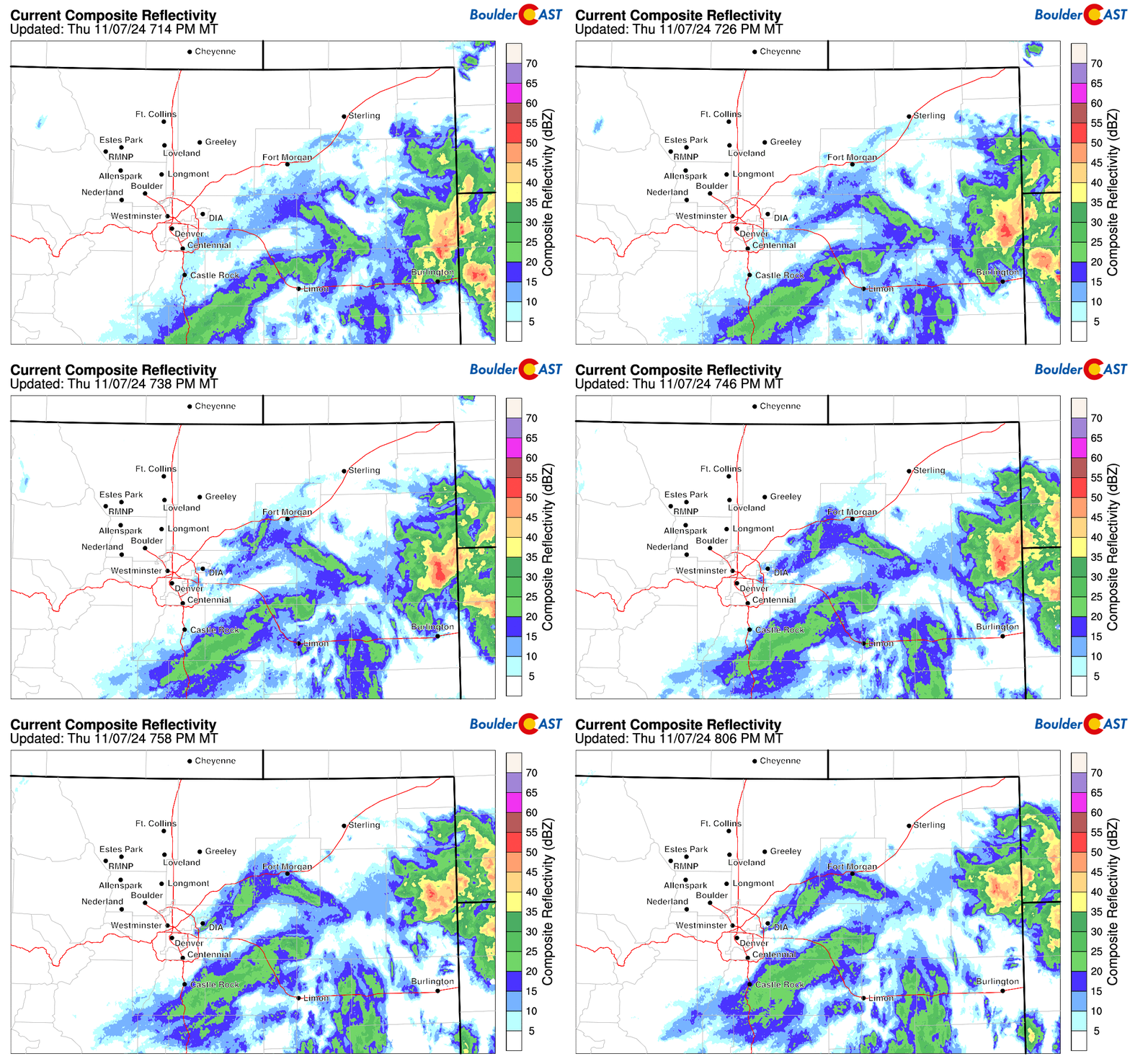
Please note: there will be a period of light snowfall between 9PM and 1AM Thursday night moving across the region from the south (see current radar below). This will lead to a dusting to 1″ of snow at best for some areas. This is NOT the main event — as mentioned, that will arrive some hours after sunrise on Friday.
That’s all we have for now. We’ll continue to keep an eye on things overnight and post a last minute Premium update in the morning (it’s now live HERE). Be sure to follow us on Twitter, Facebook, and Threads for impromptu weather updates in the coming days, or subscribe to get notified of our long-form updates like this one. Have a wonderful, snowy end to the week and be safe if travel you must!
Get BoulderCAST updates delivered to your inbox:
DISCLAIMER: This weekly outlook forecast is created Monday morning and covers the entire upcoming week. Accuracy will decrease as the week progresses as this post is NOT updated. To receive daily updated forecasts from our team, among many other perks, subscribe to BoulderCAST Premium.
Daily Forecast Updates
Get our daily forecast discussion every morning delivered to your inbox.
All Our Model Data
Access to all our Colorado-centric high-resolution weather model graphics. Seriously — every one!
Ski & Hiking Forecasts
6-day forecasts for all the Colorado ski resorts, plus more than 120 hiking trails, including every 14er.
Smoke Forecasts
Wildfire smoke concentration predictions up to 72 hours into the future.
Exclusive Content
Weekend outlooks every Thursday, bonus storm updates, historical data and much more!
No Advertisements
Enjoy ad-free viewing on the entire site.
Enjoy our content? Help us out and give it a share:




You must be logged in to post a comment.