Fortunately, as of last Friday afternoon, the wildfire smoke from Canada has cleared out of our area. However, this week will feature new weather challenges in Colorado, with the primary story being a brutally hot, dry and extended heatwave, with a secondary concern being the return of thicker smoke later in the week. Let’s take a look!
This week’s highlights include:
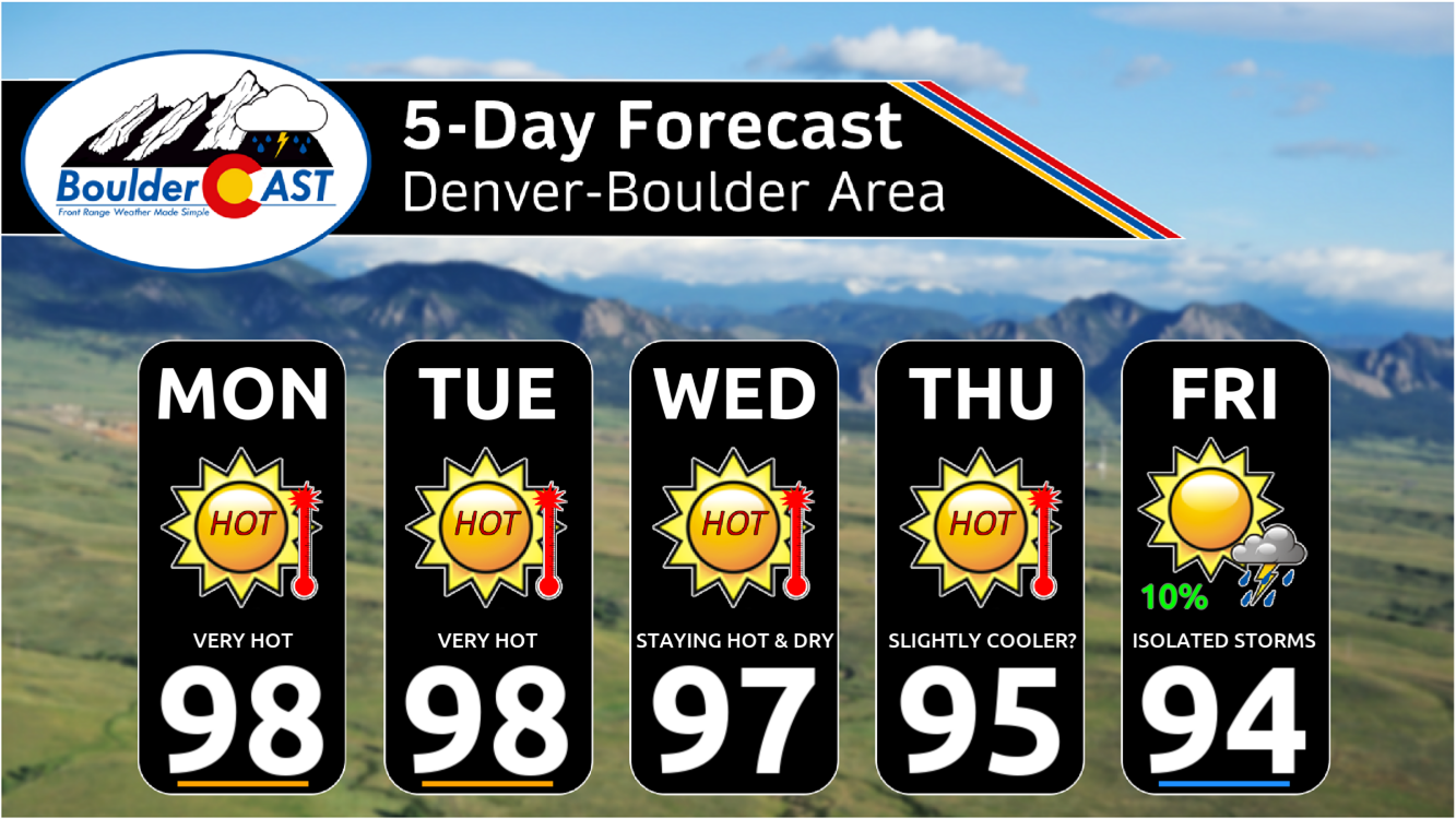
- Near Record Highs Through Wednesday: A combination of southwesterly downslope flow and bone dry air will soar temperatures in the Front Range into the upper 90s Monday through Wednesday, close to record highs.
- Exceptionally Dry as Drought Expands: Completely dry weather expected through Thursday, but a slight risk of storms will return Friday into the weekend. This is terrible news for the ongoing drought which continues to intensify across the Front Range with fire danger becoming a serious concern.
- Smoke Will Return to the Area: While minimal smoke is expected early in the week, a shifting pattern by mid to late-week will see smoke from Western fires pile up and engulf Colorado for a prolonged period.
- No Sign of the Heatwave Breaking: Only a slight cooldown is expected in the extended with temperatures staying in the 90s at least through Sunday, if not (much) longer.
DISCLAIMER: This weekly outlook forecast is created Monday morning and covers the entire upcoming week. Accuracy will decrease as the week progresses as this post is NOT updated. To receive daily updated forecasts from our team, among many other perks, subscribe to BoulderCAST Premium.

Go Premium, get all the perks.
Daily Forecast Updates
Get our daily forecast discussion every morning delivered to your inbox.
All Our Model Data
Access to all our Colorado-centric high-resolution weather model graphics. Seriously — every one!
Ski & Hiking Forecasts
6-day forecasts for all the Colorado ski resorts, plus more than 120 hiking trails, including every 14er.
Smoke Forecasts
Wildfire smoke concentration predictions up to 72 hours into the future.
Exclusive Content
Weekend outlooks every Thursday, bonus storm updates, historical data and much more!
No Advertisements
Enjoy ad-free viewing on the entire site.
Hot temperatures inbound
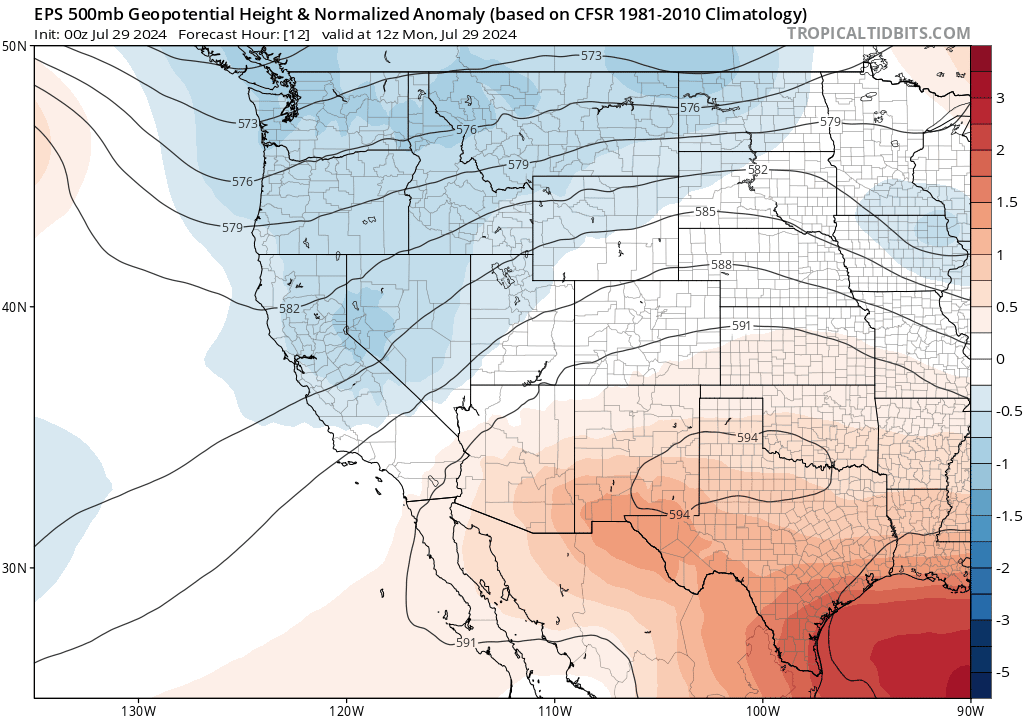
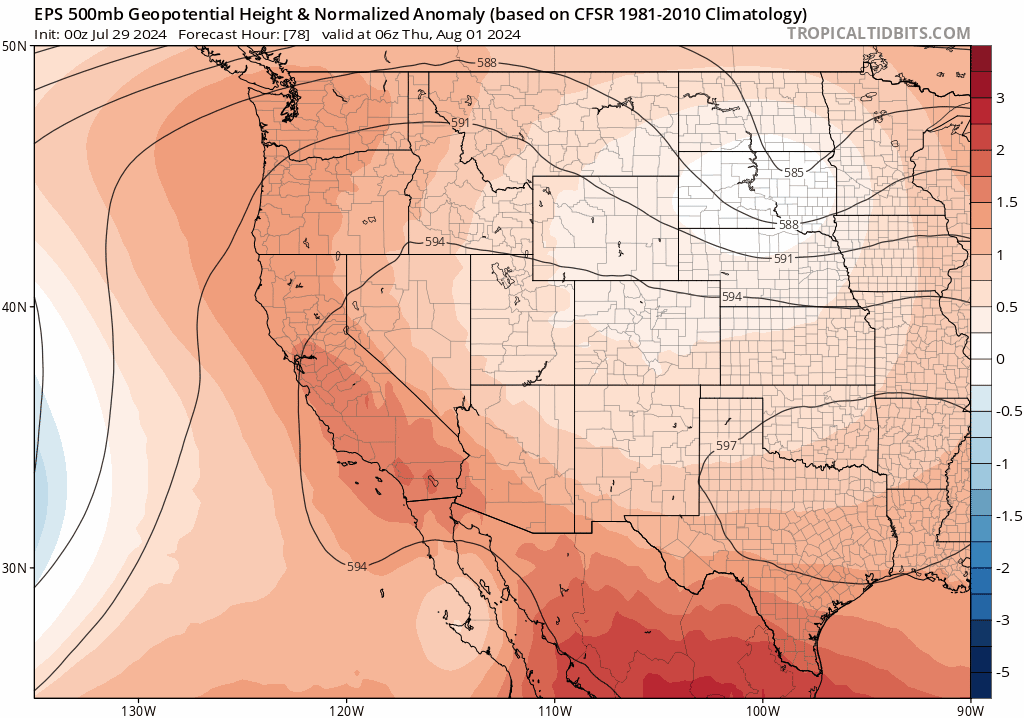
There’s no way to sugar-coat things here — the next several days will be hot across the Front Range as a ridge of high pressure stays put to our southeast in Texas. At the same time, a weak trough will be passing through the Pacific Northwest and eastward across Montana. Together these features will induce deep southwest flow into Colorado, ushering in hot air from the Desert Southwest. The early week ridge and trough can be seen in the European 500mb height anomaly forecast animation below which runs through Wednesday.
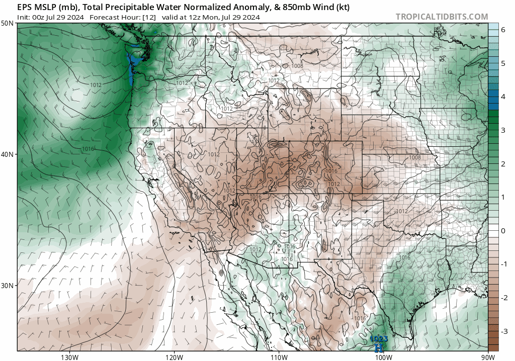
Southwest winds between two large-scale weather features like this would typically aid in the flow of monsoonal moisture to our area. However, the monsoon is completely cut-off right now and the airmass over the Desert is about as dry as it gets for this time of year. The animation below shows precipitable water anomalies for the same time period through Wednesday. Moisture levels over the entire Centennial State will be more than two standardized anomalies below normal through at least midweek.
In addition to the scorching heat, this setup will spell out bone-dry conditions for us. There’s absolutely no chance of rain Monday through Wednesday. There are some signs of moisture ticking up late-week into the weekend, which would support the risk of isolated thunderstorms Friday and beyond. However, we’re not at all optimistic that any of those would produce meaningful rainfall for us.
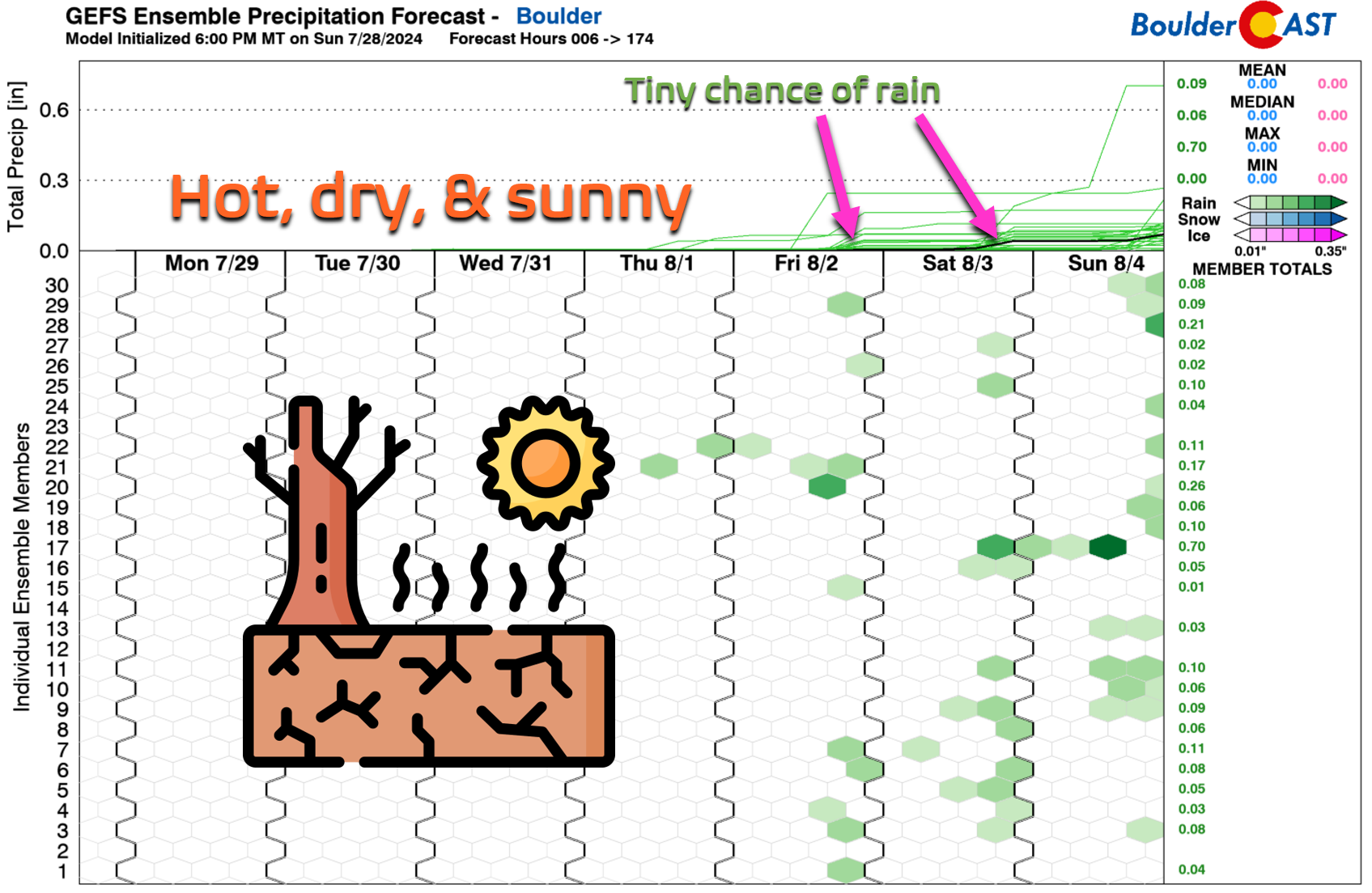
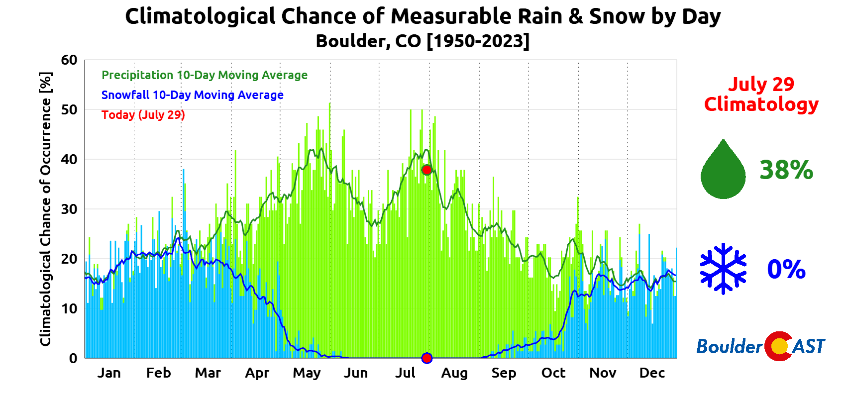
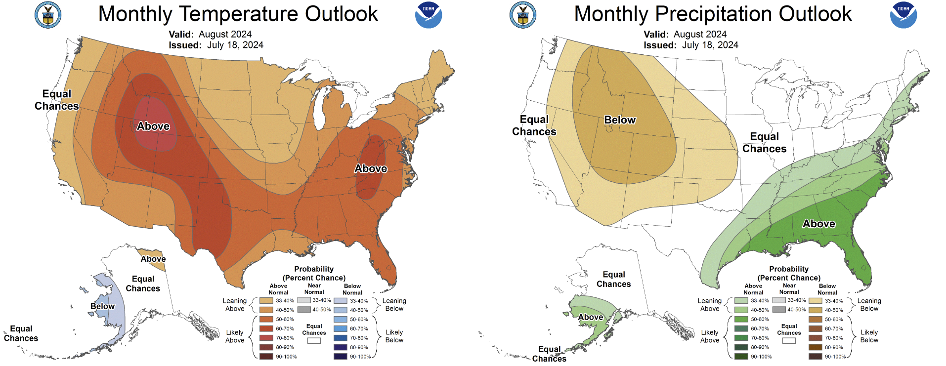
The saddest part of the dry weather about to unfold is that this time of year is typically our wettest. Late July is climatologically the peak of monsoon season with greater than 40% chances to see measurable rainfall on a daily basis. As we head into August, the chance of rain falls off a figurative cliff, with this downtrend continuing into Autumn:
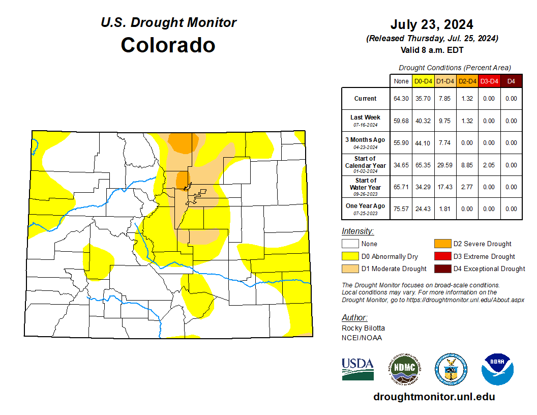
More dry weather is exactly what we don’t need right now. We undoubtedly sound like a broken record at this point, but drought continues to expand across the Front Range, with Severe Drought recently returning to parts of Boulder, Larimer and Weld Counties.
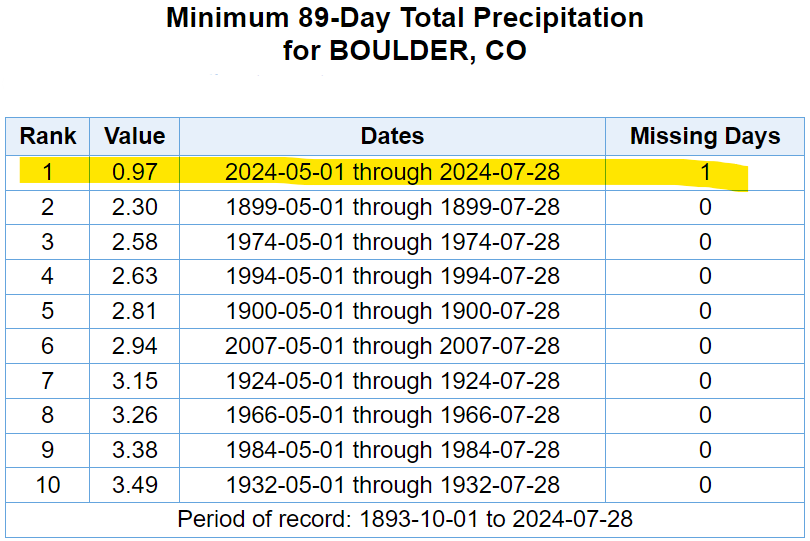
Boulder, in particular, continues to experience all-time dry conditions for the late-spring/summer period with just 0.97″ of rain falling since May 1st. This is an incredible and dire situation in Boulder County right now, especially after how wet the first four months of the year were here. Larimer County is in a similar spot as well. At this point, it’s impossible not to draw connections back to 2021, a year that ultimately ended in fiery catastrophe.
The Front Range is in terrible shape and it’s only going to get worse during the back half of summer as the (already nearly non-existent) monsoon begins to taper off and we move into the typically even drier time of year. The Climate Prediction Center is already predicting increased chances for hot and dry weather during the month of August in Colorado.
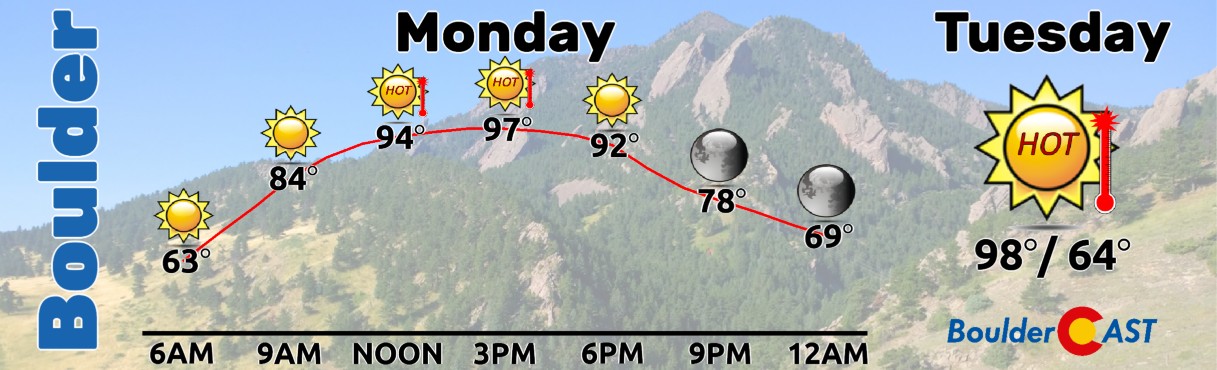
Nonetheless, we can only play the cards that we are dealt so let’s get back onto the topic of this week’s weather. The first three days of the week will be almost identical in the Denver Metro area — expect very hot temperatures, mostly sunny skies, and no hope for rain. Luckily models have backed off slightly on temperatures in recent runs by a degree or two. We’re currently forecasting highs to reach the mid to upper 90s in the Denver Metro area on Monday, Tuesday, and Wednesday.
This would put us in the running for several daily record highs. However, the pattern at-hand isn’t one we would typically expect to produce all-time records. It does have the lack of moisture going for it (which will prevent clouds/rain from forming), but the driving ridge of high pressure isn’t really that strong. We won’t fully rule out record highs this week for cities across the Front Range, but the pattern doesn’t overwhelmingly support them.
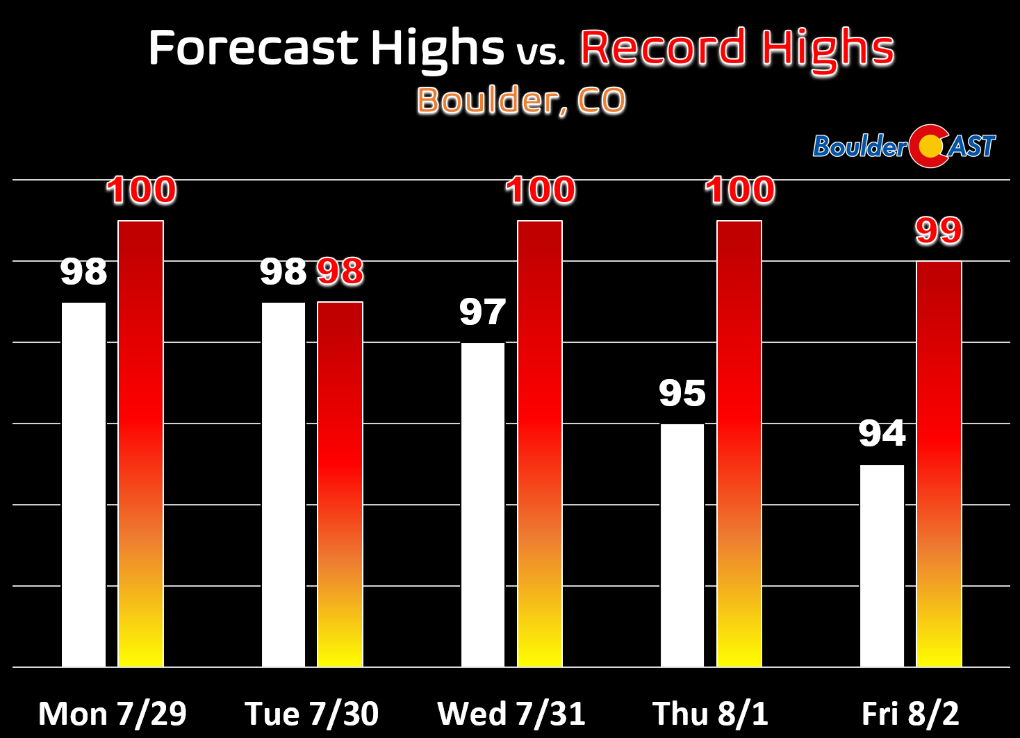
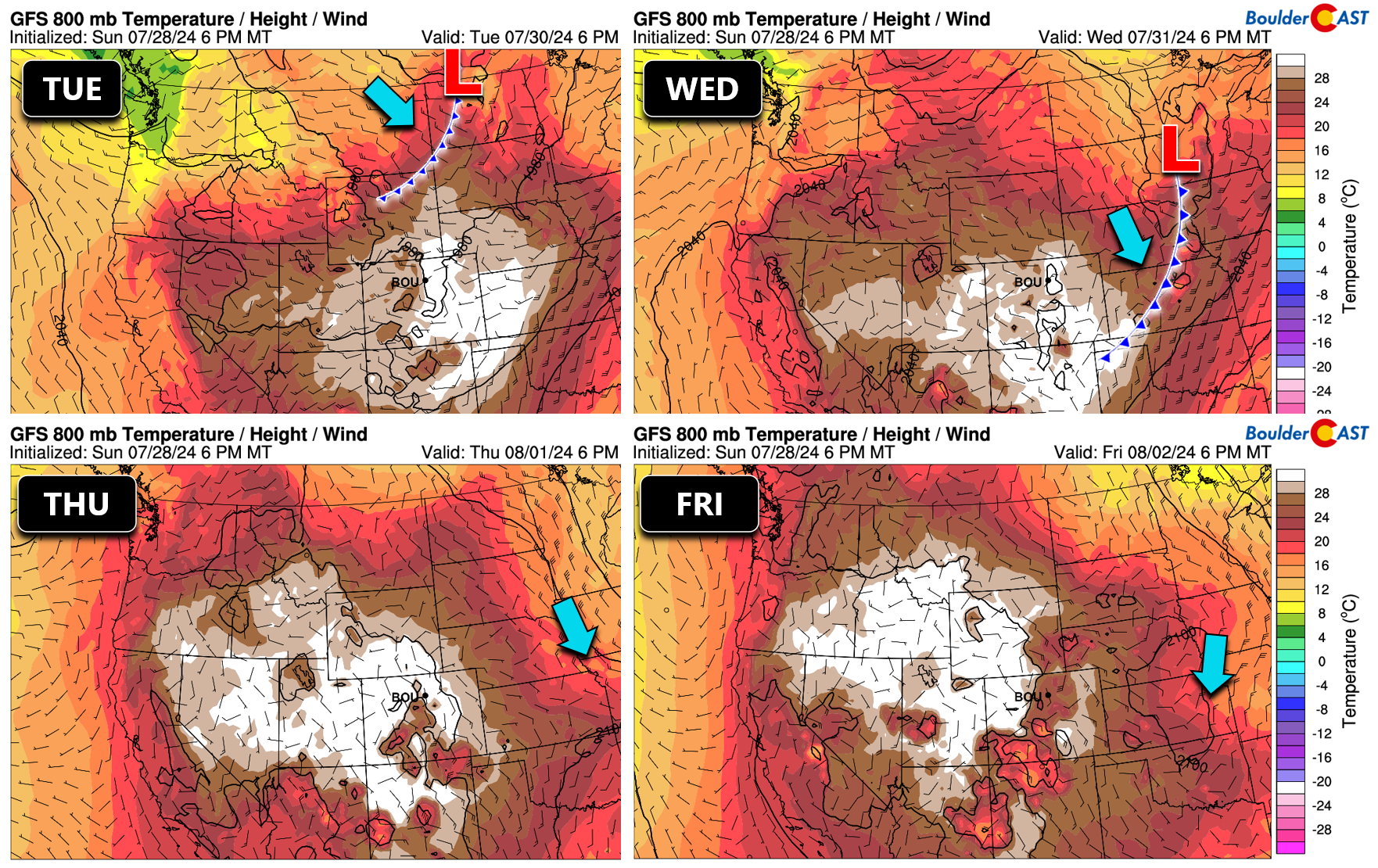
As we arrive to mid-week, the hot ridge in Texas will begin to weaken, while at the same time a meager cold front will slide across the northern Great Plains, clipping parts of eastern Colorado in the process. The front is expected to move through eastern Colorado Tuesday evening or night with hot downslope winds getting replaced by weak upslope flow Wednesday and beyond. The best chance to see more than a few degrees of cooling looks to stay east of Denver towards Kansas and Nebraska. Models are struggling to bring this cooler airmass into Denver as it’s only a glancing blow of a weak front. Still, this should drop our high temperatures back into the middle 90s for Thursday and Friday. As mentioned earlier, Friday will offer our first actual chance of rain for the week, though odds are storms will be just isolated and weak with below normal moisture remaining overhead.
Finally, let’s discuss wildfire smoke. Last week was brutal with over 100 straight hours of smoky air blanketing the Denver area before clearing out on Friday.
The smoke has cleared and those Colorado views we all egregiously overpay for have returned! #cowx pic.twitter.com/VlRoK7iYhB
— BoulderCAST Weather 🏔️❄️ (@BoulderCAST) July 27, 2024
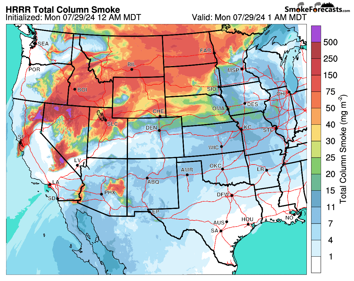
This week’s smoke situation will definitely be better than last week, but not perfect by any means. While the Canadian smoke has largely vacated the United States, there are still plenty of massive fires burning across the West, with the greatest concentration in Idaho, Oregon, and California. Moderately strong southwest winds through Tuesday will keep most of the smoke flowing past Colorado to our north, though there will be some minor pulses at times moving through. Any smoke we see early in the week would largely be lofted in the atmosphere, so only minor impacts to air quality should occur. The total smoke forecast through Tuesday evening is shown below, indicating we may also see some smoke from smaller fires burning in Arizona and Mexico. The weak cold front Tuesday night is likely to bring with it some low-level smoke to eastern Colorado. It’s unclear exactly how much there will be, but do plan on smoke increasing for Wednesday.
Late in the week, we’ll start to see upper-level winds greatly weaken as a new, massive ridge of high pressure spawn across the West. The formation of this secondary, much stronger ridge is shown in the European ensemble 500mb height anomaly animation below spanning from Thursday through Sunday. The concentric nature of this ridge (and calm winds within) will likely allow thick smoke to accumulate across much of the West, including here in Colorado. With this, we definitely expect to see smokier conditions stay the course across our area through the upcoming weekend and perhaps longer. Most long-range models indicate that this ridge will be parked over the Four Corners area for a long time, so any smoke that does move in won’t be in any hurry to exit. With the exception of last week, smoke really hasn’t been too bad this summer. That’s about to change! Stay up to the date with the smoke on our Colorado Smoke Forecast page.
Enjoy the week, stay cool, and let’s try to avoid starting any wildfires in this wonderful yet terrifying tinderbox we all call home…
Forecast Specifics:
Monday: Hot & dry with just a few late-day clouds forming. High temperatures will approach record values in the upper 90s on the Plains with middle 80s in the Foothills.
Tuesday: Hot & dry again with just a few late-day clouds forming. High temperatures will approach record values in the upper 90s on the Plains with middle 80s in the Foothills.
Wednesday: Staying hot and dry with just a few late-day clouds forming. Temperatures may be a shade cooler following an overnight cold front. Smoke from California will also increase behind the front leading to degraded air quality and visibility. High temperatures will approach record values in the mid to upper 90s on the Plains with middle 80s in the Foothills.
Thursday: Mostly sunny and slight cooler, but still quite hot. Smoke will be around again with degraded air quality and visibility region-wide. Highs reach the middle 90s on the Plains with lower 80s in the Foothills.
Friday: Morning sun giving way to some afternoon clouds with a slight chance of an isolated thunderstorm producing very little rainfall (10%). Temperatures reach the low to middle 90s on the Plains with near 80 in the Foothills.
Weekend: Staying hot with highs in the 90s and a slight risk of late-day storms (10-20%).
Get BoulderCAST updates delivered to your inbox:
DISCLAIMER: This weekly outlook forecast is created Monday morning and covers the entire upcoming week. Accuracy will decrease as the week progresses as this post is NOT updated. To receive daily updated forecasts from our team, among many other perks, subscribe to BoulderCAST Premium.
Go Premium, get all the perks.
Daily Forecast Updates
Get our daily forecast discussion every morning delivered to your inbox.
All Our Model Data
Access to all our Colorado-centric high-resolution weather model graphics. Seriously — every one!
Ski & Hiking Forecasts
6-day forecasts for all the Colorado ski resorts, plus more than 120 hiking trails, including every 14er.
Smoke Forecasts
Wildfire smoke concentration predictions up to 72 hours into the future.
Exclusive Content
Weekend outlooks every Thursday, bonus storm updates, historical data and much more!
No Advertisements
Enjoy ad-free viewing on the entire site.
Enjoy our content? Give it a share!


You must be logged in to post a comment.