Following the active day of weather in Colorado on Sunday — from thunderstorm to snow to blowing dust — things quiet down to begin the week. However, it won’t remain that way for too long! Our next storm system will approach mid-week bringing a chance of rain and possibly accumulating snow to the Denver Metro area. The Mountains will likely pick up another round of powder as well. Let’s take a look at the weather week ahead for the Front Range.
This week’s highlights include:
- A strong storm brought blowing dust, heavy mountain snow, thunderstorms, and even some wet snow to the area on Sunday
- Dry to begin the week with seasonal conditions Monday and Tuesday under partly cloudy skies
- Our next storm to watch arrives late Wednesday into Thursday and will offer a chance of rain and accumulating snow across the Denver Metro area
- Thursday will be the coldest day of the week wit highs only in the 40s at best
- Quiet weather returns Friday with sunshine and highs near 60 degrees
DISCLAIMER: This weekly outlook forecast is created Monday morning and covers the entire upcoming week. Accuracy will decrease as the week progresses as this post is NOT updated. To receive daily updated forecasts from our team, among many other perks, subscribe to BoulderCAST Premium.
A varied day of weather on Sunday
All is quiet across northeast Colorado this morning as the first storm system of the season pulls away from the area with drier downslope flow having taken hold quickly overnight. On Sunday we saw moderate to heavy snow in the Mountains with snow-covered roadways impacting travel at times. Some areas saw more than a foot of snow.
Snow is already covering the roadways in the Mountains and it will continue through the rest of Sunday, heavy at times. Travel carefully! #cowx pic.twitter.com/qIw0uMWI3y
— BoulderCAST Weather (@BoulderCAST) October 23, 2022
A few thunderstorms fired up around Fort Collins in the afternoon — possibly some of the last storm activity of the waning convective season.
Yep a few rumbles!
— BoulderCAST Weather (@BoulderCAST) October 23, 2022
Strong winds ahead of the system created a massive dust storm in far eastern Colorado, Kansas and Nebraska.
Incredible satellite imagery of dust and smoke sweeping across the U.S. Plains. pic.twitter.com/Gt3s44upcA
— Dakota Smith (@weatherdak) October 23, 2022
Finally, there were a few spotty light rain/snow/graupel showers that developed late Sunday evening over the heart of the Denver Metro area, technically giving some cities their first trace of snow for the season including Denver International Airport.
I’ve got graupel accumulation in north Arvada. Currently 39°. #COwx #9wx graupel is not hail or snow btw pic.twitter.com/3PsyYSjTke
— Cory Reppenhagen (@CReppWx) October 24, 2022
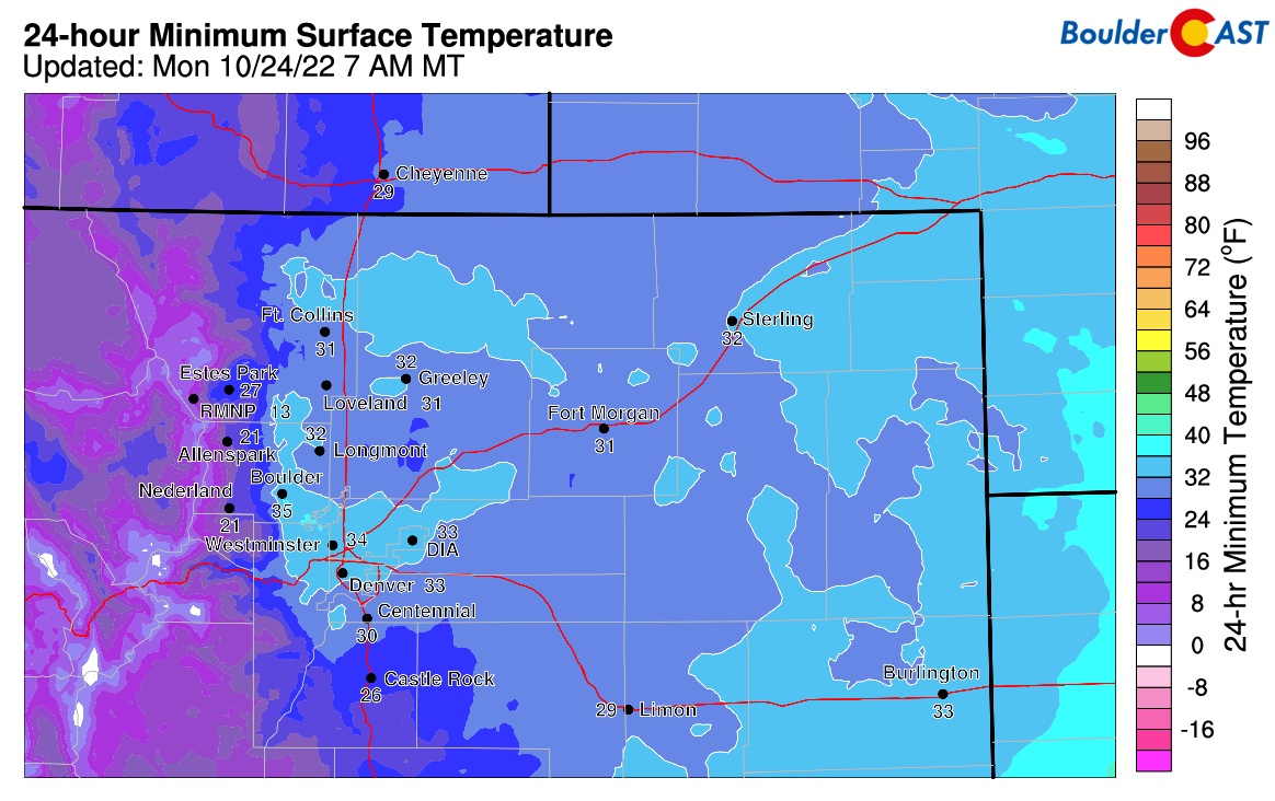
Based on temperatures early Monday morning, it looks like much of the Denver Metro area has dodged sub-freezing temperatures once again. Denver International Airport did drop to 31°F briefly, officially Denver’s first freeze of the season. Westerly downslope winds never fully-relaxed and lessened the amount of cooling overnight. Thus the growing season continues in most locations but remains clearly on life-support as we wrap up the last full week of October and flirt with freezing temperatures many nights in the days ahead…
Seasonal temperatures for once
As of early Monday morning, the deepening trough across the West has actually split into two distinct pieces of energy — 1) the stronger colder low pressure is over the Dakotas which will get swept into Canada and 2) a secondary cut-off low which is trying to develop across the Four Corners. This southern piece of energy will bring light rain/snow to southern Colorado and New Mexico through the day. Perhaps not surprisingly, this splitting setup is partially to blame for the lack of much precipitation across our area with this particular storm system — unfortunately we mostly ended up between the two!
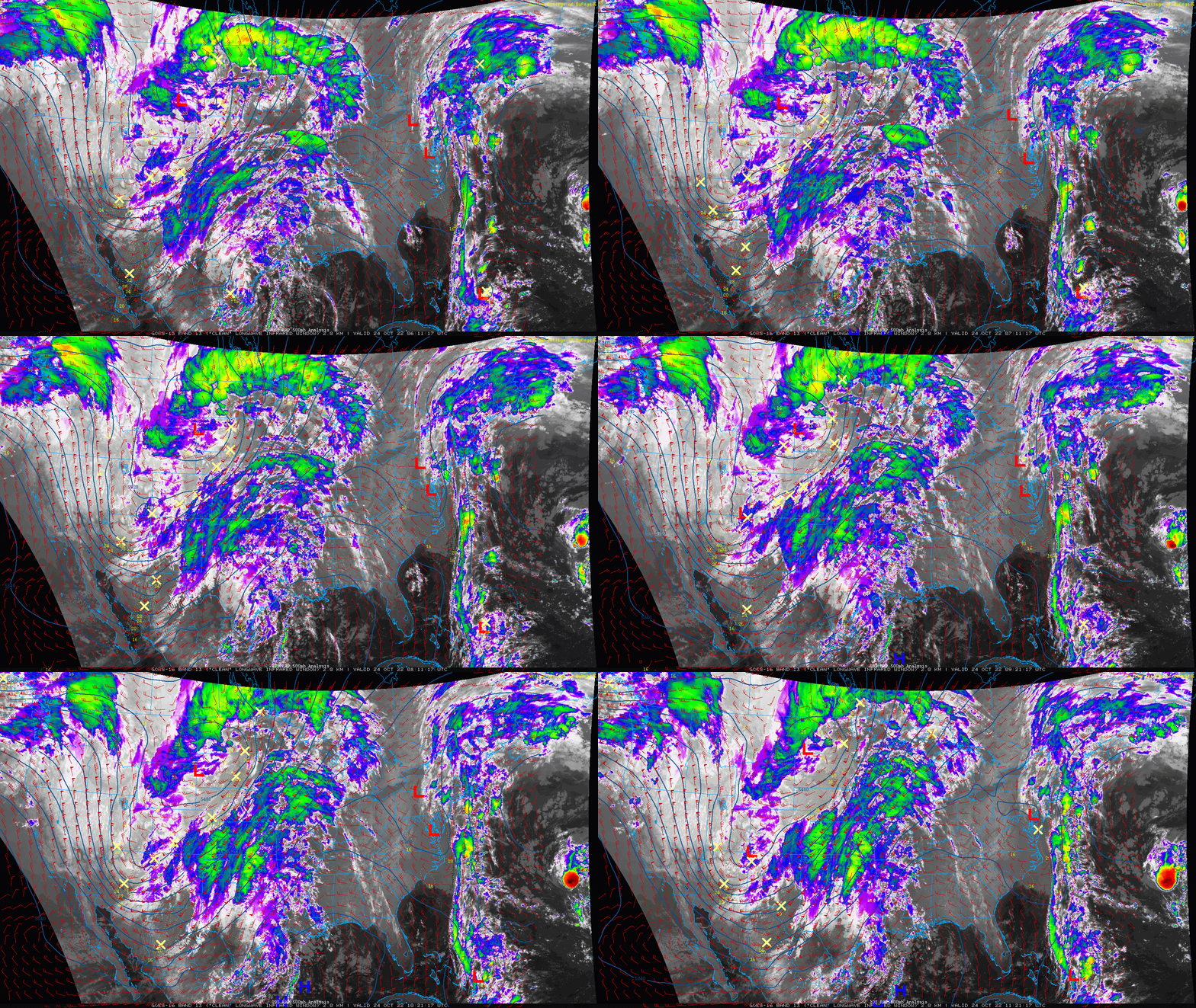
GOES-East infrared satellite animation from early Monday morning showing the trough across the West and its two distinct pieces of energy
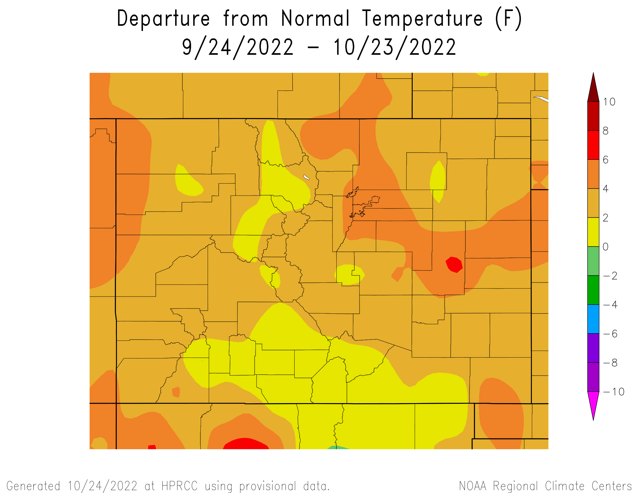
The week ahead will admittedly be a cooler one overall but this falls much closer to normal than anything we’ve seen of late. Over the last thirty days, the Front Range is trending 3 to 5 degrees above normal — certainly a contributing factor towards the late arrival of our first accumulating snow and the first wave of widespread sub-freezing temperatures. We are still waiting on both…
As quickly as the weather turned ugly on Sunday, it will shift quiet once again for our Monday with partly to mostly sunny skies and just breezy conditions during the evening. High temperatures will be around 50 degrees which won’t feel too bad with the sunshine. Tuesday will be fairly nice as well but closer to 60 degrees.
Throughout the week ahead, broad west and northwest flow will be a mainstay over Colorado leading to those seasonal conditions. There will be two features to watch in this flow — a weak system on Tuesday evening which scoots across Wyoming. This should only bring impacts to the Mountains with light accumulations of 1 to 3″ for northern Colorado. The only impact on Tuesday for the Metro area will be some wave clouds. A weak cold front will slide south across our area Tuesday night making for a slightly cooler mid-week — look for mid to upper 50s on Wednesday.
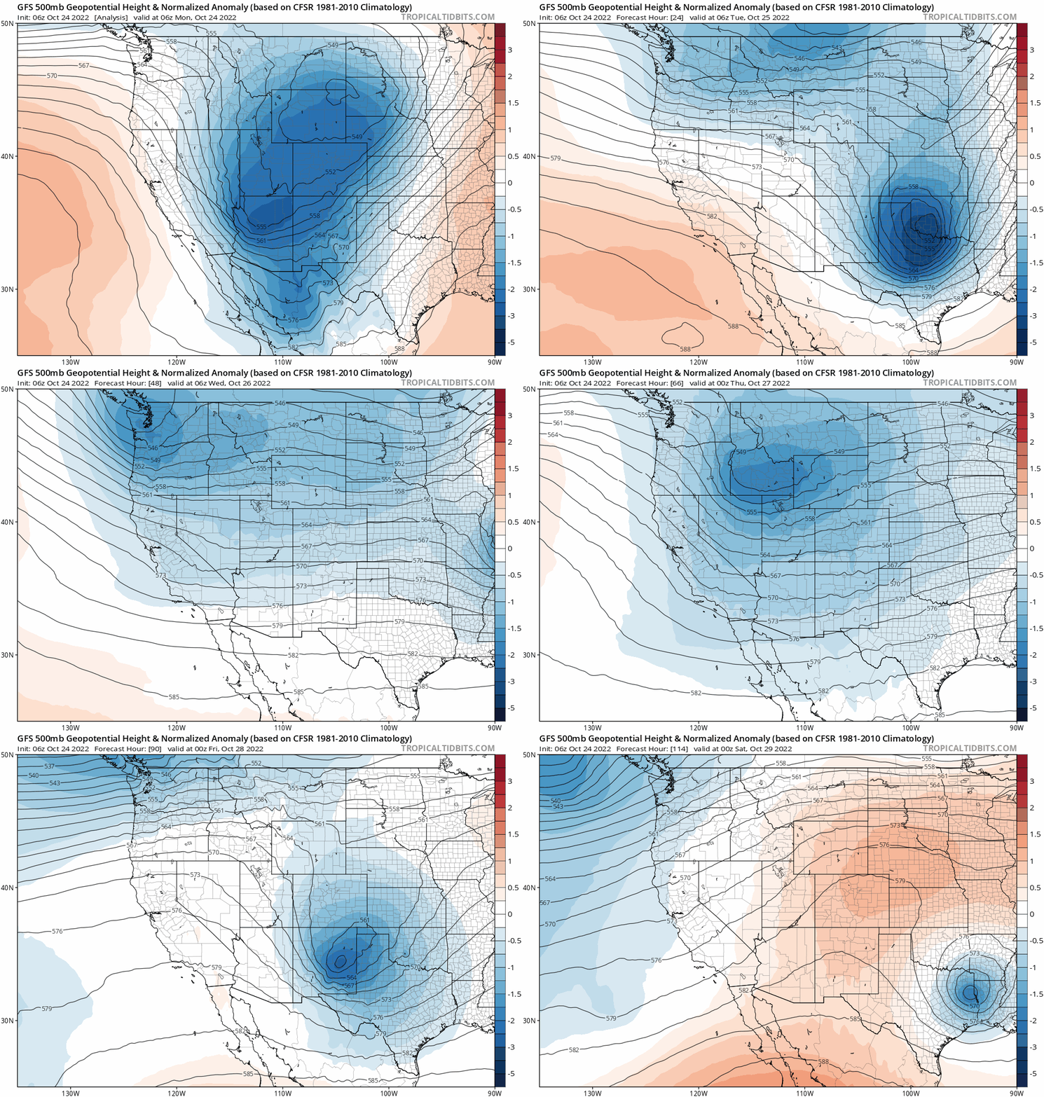
GFS 500mb height anomaly forecast animation from Monday through Friday. Several system will be impacting Colorado this week!
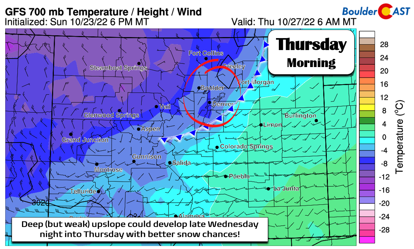
The more interesting feature of the week arrives in the form of a small but vigorous trough late Wednesday into Thursday. It’s still several days away, but early signs point to this system offering a better chance of upslope-enhanced light precipitation across the Denver Metro area — with a good probability that it would be cold enough for some snow again. While far from an ideal setup, we are seeing indication of deeper upslope developing behind this system’s main cold front. For example, shown below is the GFS temperature and wind forecast for Thursday morning at the ~10,000-foot elevation level. Northeasterly (upslope) winds are indicated in this model forecast across the Front Range with temperatures around -6°C. This would be cold enough for snow, especially given the overnight/morning timing.
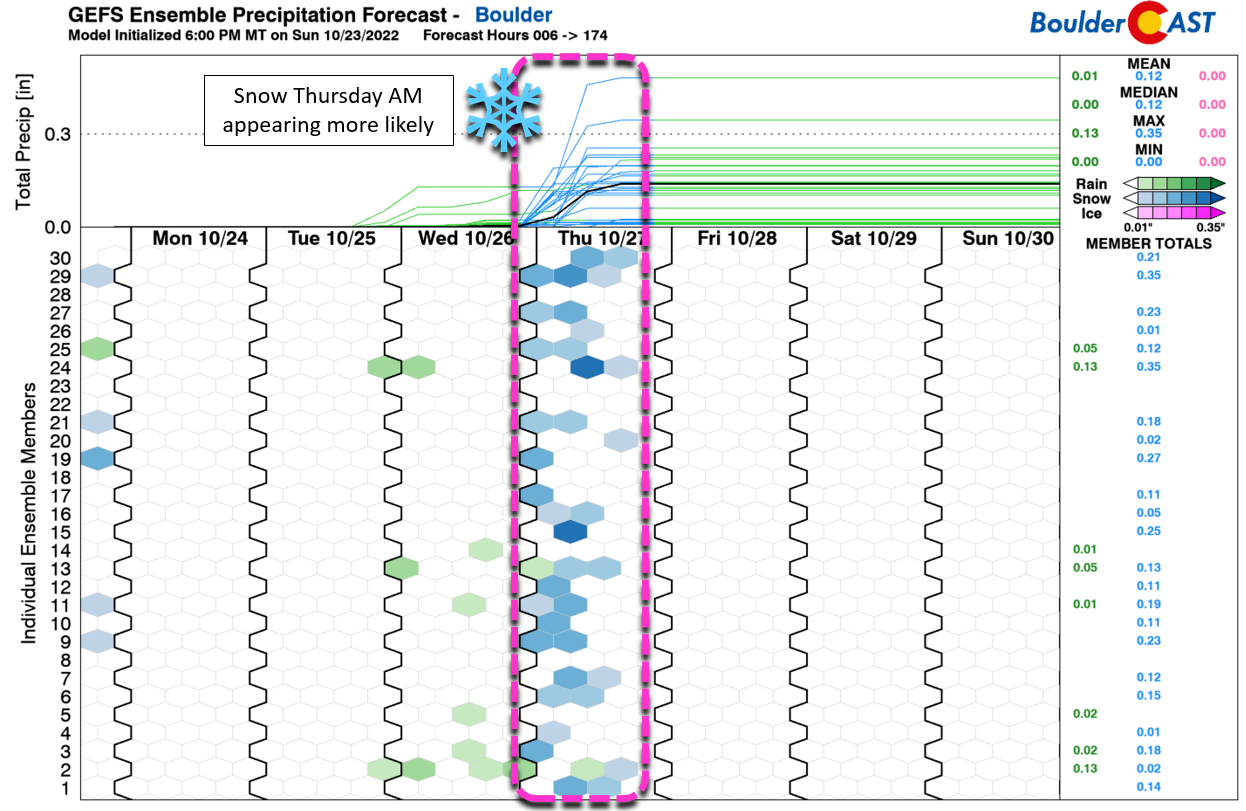
The GFS ensembles look promising to say the least, with decent agreement for a light accumulation of snow for the area Wednesday night into early Thursday. The overall ensemble mean and median are both around 1″ of snow in Boulder.
It’s certainly something to watch for now, especially for those with a stake in our 2022 First Snowfall Contest. We are a bit concerned that models may back off from this feature in the coming days, possibly taking it even further south. It’s not an overwhelming feature in the flow so changes in the models are more likely to occur. They have already been trending less aggressive with the amount of cold air coming into Colorado. Nonetheless, we will include scattered rain and snow showers in the late Wednesday into early Thursday timeframe with temperatures staying well below normal in the 40s for Thursday.
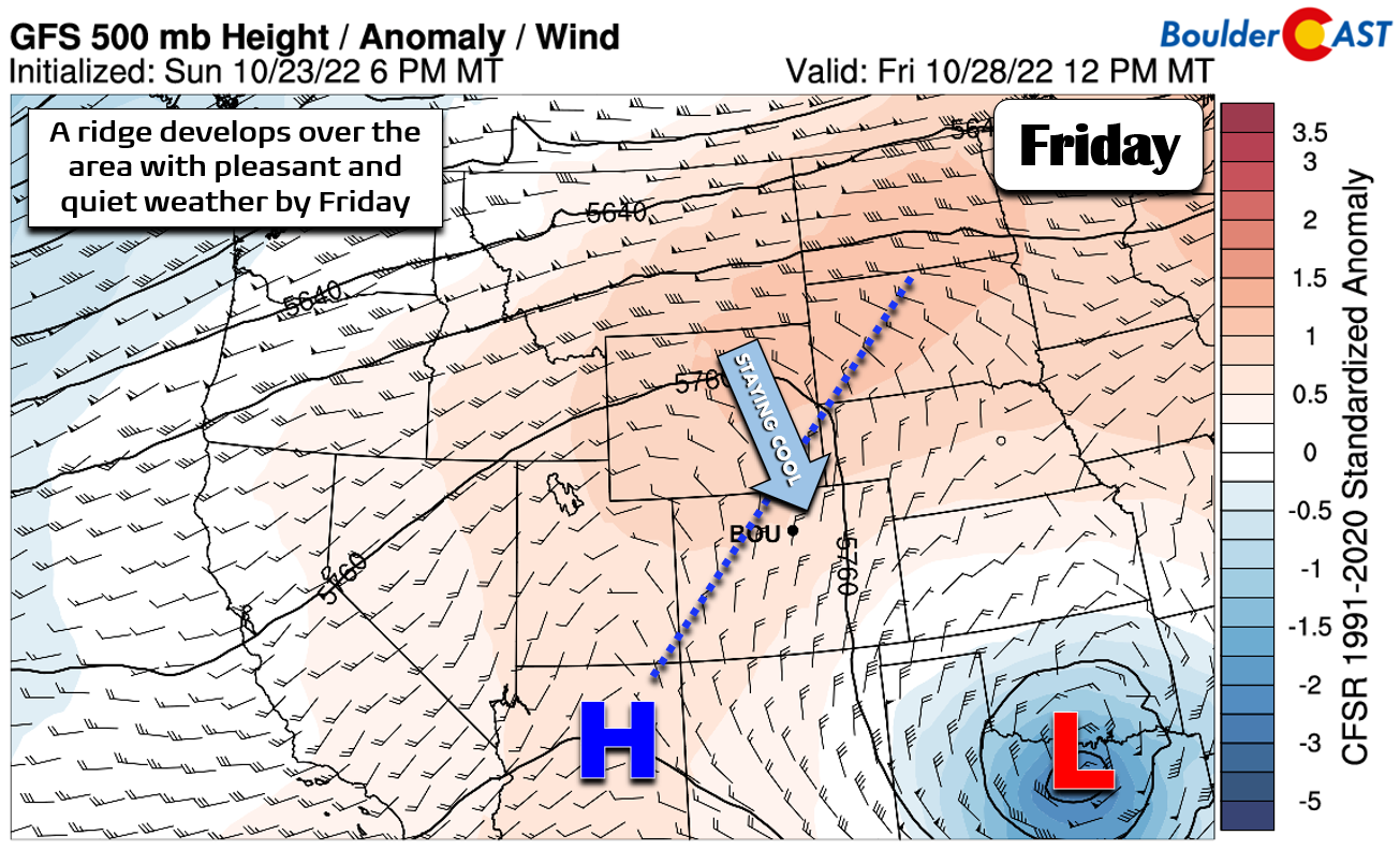
By Friday, things will clear out with a shortwave ridge developing across the Rockies. This will lead to a pleasant but cool day with high temperatures likely returning towards 60 degrees.
Stay tuned for updates in the coming days about that next chance of snow. Have a seasonal week!
Forecast Specifics:
Monday: Partly to mostly sunny and cool with highs around 50 degrees on the Plains and in the upper 30s in the Foothills.
Tuesday: Partly cloudy and warmer with temperatures reaching the lower 60s on the Plains and the upper 40s in the Foothills.
Wednesday: Partly cloudy with a slight chance of late-day rain showers, eventually turning to snow Wednesday night. Highs in the upper 50s on the Plains with middle 40s in the Foothills.
Thursday: A chance of light snow in the morning with minor accumulations possible, then skies clear by afternoon and evening. Highs reach the middle 40s on the Plains with lower 30s in the Foothills.
Friday: Sunny skies and seasonal temperatures. Look for highs to reach near 60 degrees on the Plains with middle 40s in the Foothills.
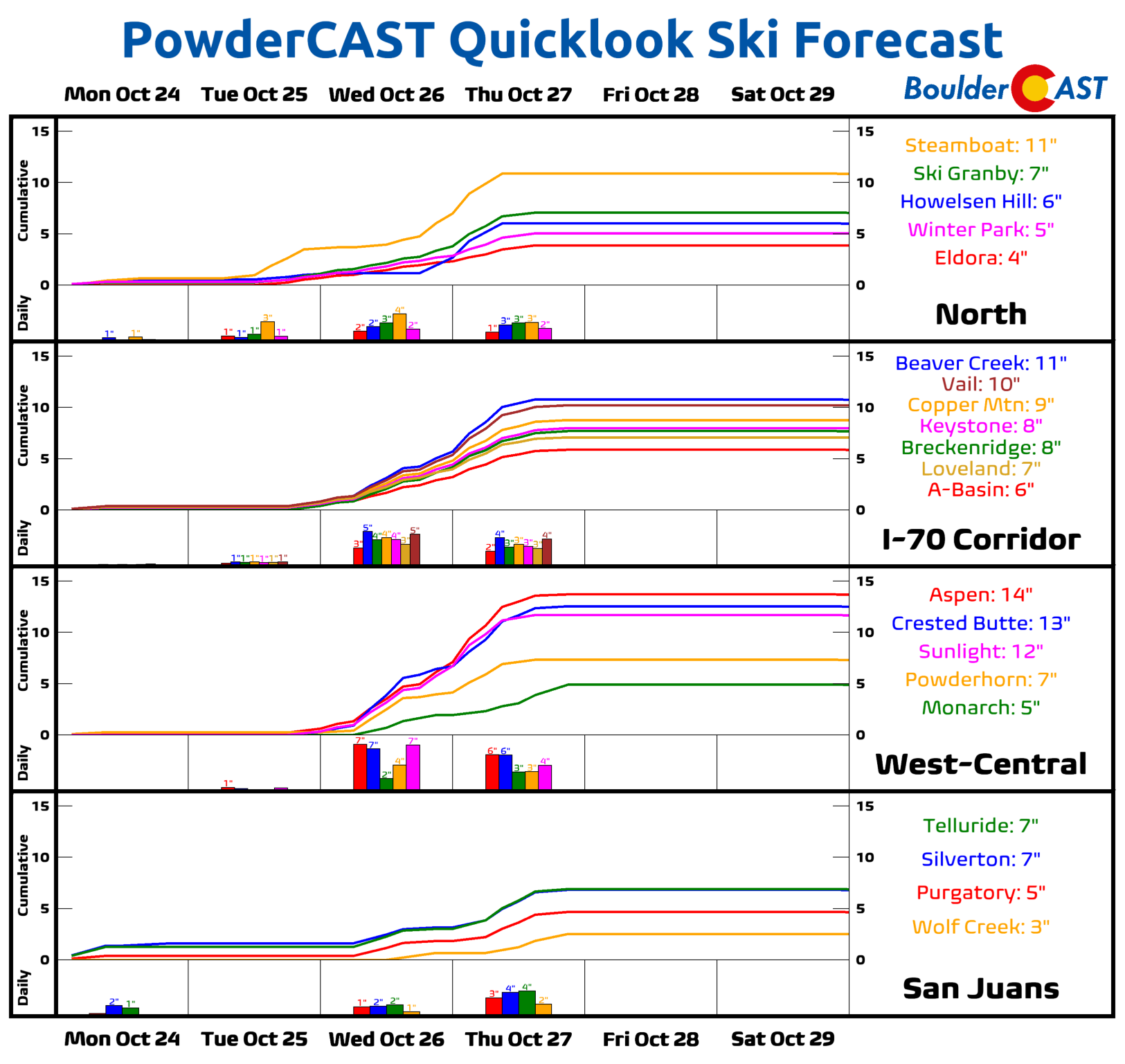
High Country: Lingering light snow showers will taper off early Monday morning with dry conditions through Tuesday morning. A weak system will bring snow again to the area Tuesday evening with 1-3″ of accumulation for the northern Mountain. The main system of the week moves in Wednesday into Thursday with widespread snowfall in the Mountains with another 6 to 12″ not out of the question for many ranges. The entire state dries out Friday and warms up as a brief shortwave ridge develops over the Rockies.
Help support our team of Front Range weather bloggers by joining BoulderCAST Premium. We talk Boulder and Denver weather every single day. Sign up now to get access to our daily forecast discussions each morning, complete six-day skiing and hiking forecasts powered by machine learning, first-class access to all our Colorado-centric high-resolution weather graphics, bonus storm updates and much more! Or not, we just appreciate your readership!
Spread the word, share the BoulderCAST forecast!






You must be logged in to post a comment.