With Turkey Day nearly upon us, this week’s forecast will feature another chance of snow and our first dose of Arctic cold air. We have high confidence that just about all of Boulder County is in store for a white Thanksgiving. Read on for all the frigid details!
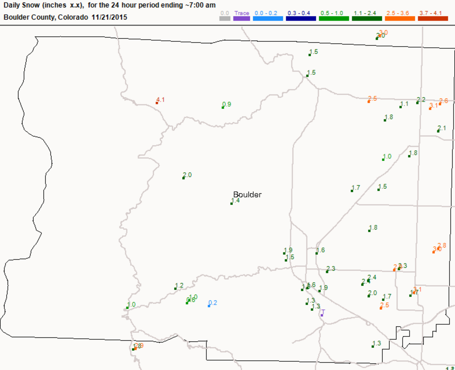
Despite the forecasting woes of last week’s storm, everyone across the Front Range should have gotten at least a little taste of snow on Friday night, with a general 1-3″ falling across most of Boulder County as a weak front moved through (see map below). This time there was plenty of cold air.
The recent weeks across Colorado have been relatively active, with a storm system arriving about every five or six days on average. The active pattern doesn’t look to show any signs letting up just yet!
Our week will begin mild and tranquil.
The 500 mb vorticity map for this afternoon is shown below. Notice the zonal flow and even slight ridging across Colorado.
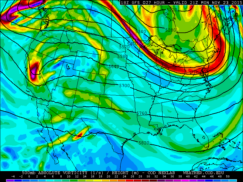
GFS 500 mb height and vorticity map for Monday afternoon. A weak ridge is present across our region, but our next storm system can be seen looming in the Gulf of Alaska.
There is a tiny shortwave trough visible above in California. This system will quickly skirt through southern Colorado on Tuesday. It has extremely limited moisture to work with and remain to our south, so we don’t expect it to have any impact on our weather, outside of a few high clouds. Temperatures on the Plains will be fairly warm, climbing to near 60 degrees.
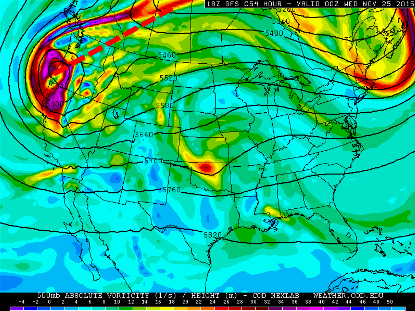
By Tuesday afternoon, we can see this week’s main weather system now ashore in the Pacific Northwest. The trough already has a significant positive tilt (axis looks like a forward slash), which is outlined in a dashed red line below. This generally indicates a weak or weakening system.
Tuesday will also be fairly nice. There may be a few more clouds around compared to Monday, but temperatures should once again top out in the low 60’s.
Wednesday will be a day of transition. A cold front associated with the main trough will plunge into northeast Colorado during the late morning or early afternoon. Under gusty southwesterly winds, temperatures ahead of the front will probably climb in the 40’s or low 50’s, but will rapidly fall through the 30’s, 20’s, and into the teens overnight. Initially, there won’t be enough moisture to produce much precipitation in Colorado, so Wednesday will be largely dry, save a chance of a few light snow showers after dark. Snow showers will increase in coverage after midnight Wednesday night.
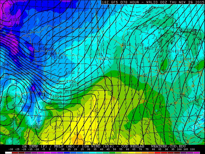
Surface temperature, wind, and pressure from the GFS model, valid Wednesday afternoon. A cold front has already moved through our region, evident by NE winds and a strong temperature gradient across the state.
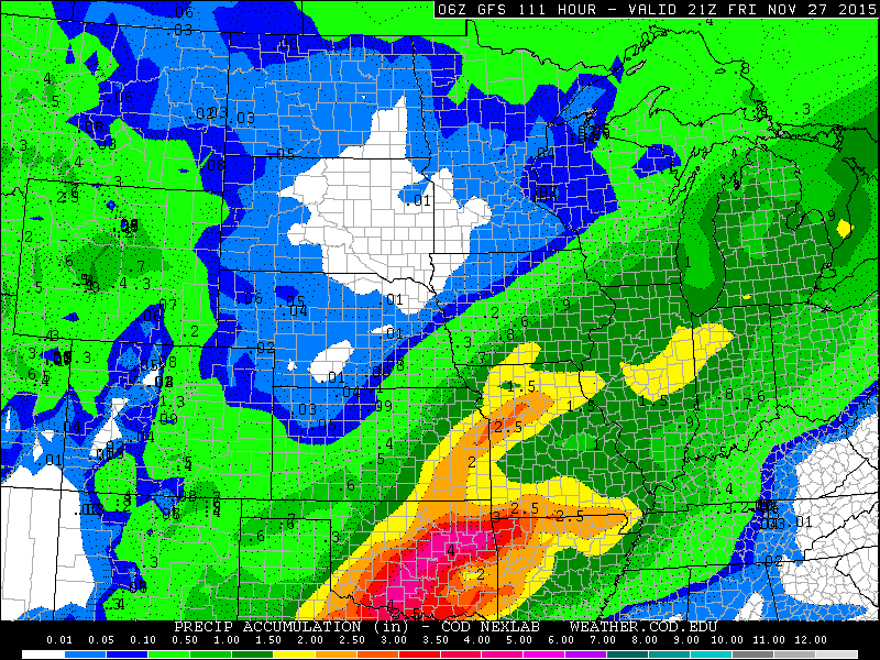
A word of caution: at this point, the models have this weather system cutting off, and then meandering across Nevada, Idaho, and Utah through the weekend. This is observed in the GFS, Canadian, and Euro. We will have to see how this plays out. At this time, the system appears too weak to spit out anything impressive in the way of snow. However, whenever a system is progged to move this slow, it bears watching.
Light, shallow upslope will continue through most of Thanksgiving Day and into Friday morning, keeping skies overcast and a chance a snow showers through the day. This is in response to a dome of Arctic high pressure sliding south through Montana (1042 mb!). The counterclockwise flow around the high will persist in Colorado for 36 to 48 hours, possibly longer.
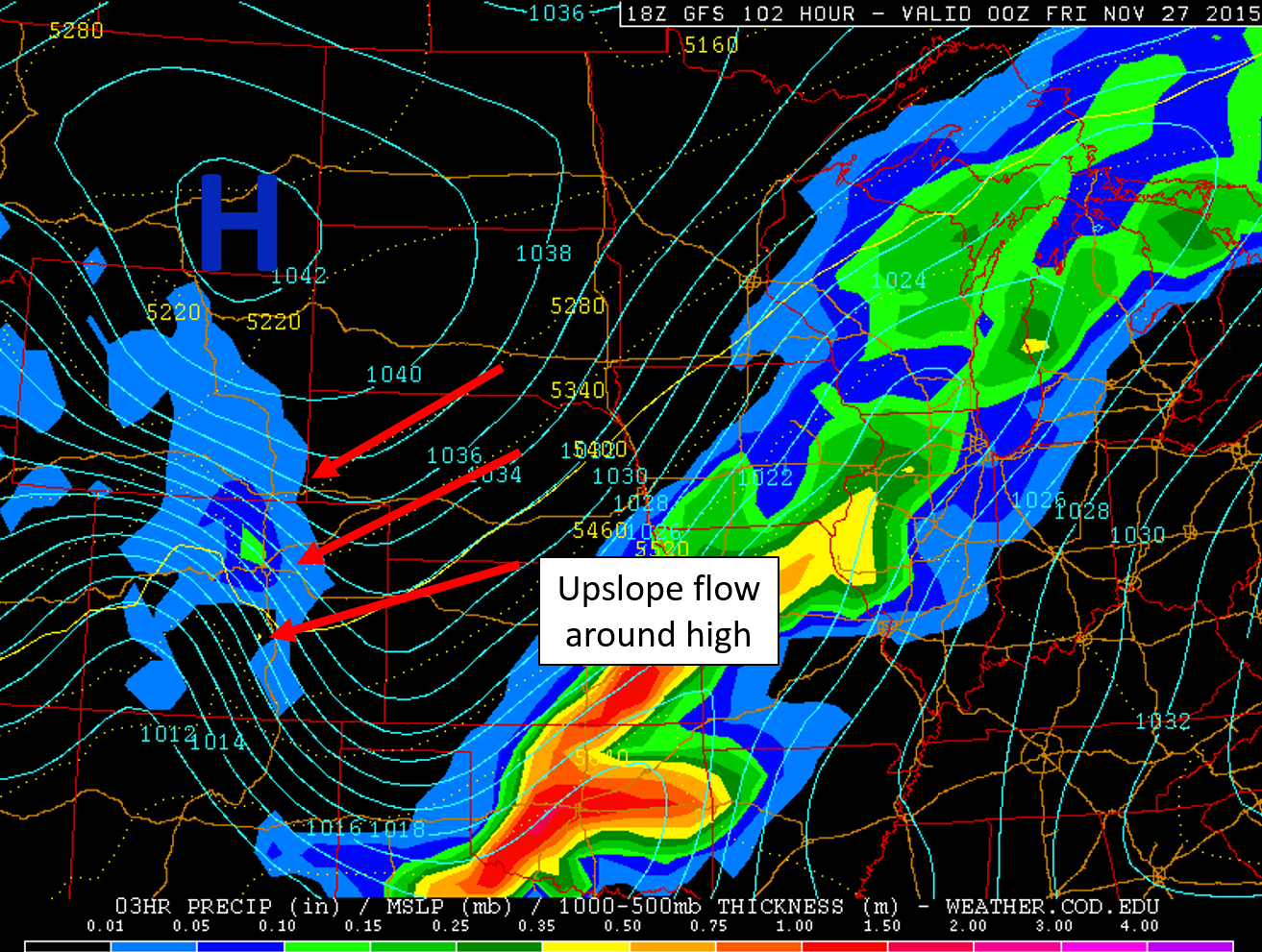
GFS pressure and precipitation map for Thursday evening. Notice the intense high over eastern Montana, driving upslope into eastern Colorado.
Don’t expect too much snow.
Still, the cold air mass is very shallow and dry, and the system, as we hinted, isn’t all that impressive. Despite the long duration event, snowfall rates will be tiny throughout. The main forcing will be persistent, but weak upslope. This will favor areas like the city of Boulder and the Foothills for snow, more so than the Denver Metro.
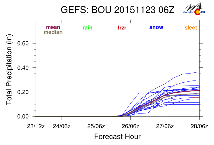
It is too early to place our official bets just yet, but for now, we are thinking 1-4″ of accumulation for the Plains from late Wednesday night through Friday morning. The higher elevations could see more like 6″.
It looks like a widespread light snow event, with most of Wyoming, eastern Colorado and NE New Mexico getting in on the action. Right now, the best snow looks to set up in central Wyoming, but there is still plenty of time for things to evolve. We are fairly confident that everyone will have a white Thanksgiving across Boulder County! The snow, combined with cold temperatures, will likely produce some slick roads across the region, particularly Thursday evening and night. Not the best timing, but do be careful if you are traveling to meet up with family and friends.
The Arctic air mass is the real story.
It is near certain we won’t get out of the 20’s on Thursday or Friday. We could even see temperatures dip into the single digits Friday and Saturday mornings. Some light, but gusty at times, wind could make for some dangerous wind chills. Be sure to bundle up if you have any outdoor plans during the holiday!

GEFS plumes for surface temperature in Boulder. Thursday and Friday likely wont get out of the 20’s.
Be sure to check back on Wednesday for an update on how much snow to expect! Subscribe to our posts to stay even more in the loop!
The Forecast:
Monday: Mostly sunny and warm. Highs for the Plains in the low 60’s, with 50’s in the Foothills.
Tuesday: Mostly sunny early, then partly cloudy. Highs in the low 60’s again for the Plains, with mid 50’s in the Foothills.
Wednesday: Breezy early with temperatures in the 40’s. A cold front will cause plummeting temperatures, falling into the 20’s by evening. A slight chance of light snow showers in the late evening, otherwise dry.
Thursday: Overcast and cold, with on-and-off light snow through the day. Highs on the Plains in the mid 20’s, with low 20’s in the Foothills.
Friday: Very cold with a few light snow showers in the morning. A couple peaks of sun in the afternoon are possible. Highs in the low 20’s for the Plains, with upper 10’s in the Foothills. Brr!
Source
Mon
Tue
Wed
Thu
Fri


BoulderCAST
60
60
46
26
24


NWS
59
58
45
26
20


AccuWeather
58
59
48
27
22


The Weather Channel
57
59
45
29
25
Last week’s recap:
Here are the results of last week’s forecast. First, the forecasts and observations from all of the sources:
Last week’s story was a busted snow forecast on Monday. Officially, we got 0.1″ of snow, thanks to downslope warming and a system that tracked just a bit too far south. We expected a big cool down on Tuesday, with temperatures returning to near normal for Wednesday through Friday.
Let’s look at the error analysis. Shown below is the amount of degrees (in Fahrenheit) that each source was off from the mean observed temperature for Boulder. Positive values indicate the forecast was warmer than what actually occurred, while negative values arise from a forecast that was cooler than what was observed.
The worst forecast day of the week ended up being Tuesday, with more than 14 degrees of error. This was related to our snow forecast busting, and was discussed in more detail in a previous post. The last three days of the week were forecasted quite well, surprisingly.
The bottom row of the error table shows the weekly mean error for each weather outlet, a good measure for who was the best and more consistent “forecaster” for the week. AccuWeather takes first place this period, with 4.0 degrees of error. BoulderCAST fell just short, and takes second place, having the best forecast on Friday. The NWS is once again in last, thanks in part to a horrific temperature forecast on Tuesday.



You must be logged in to post a comment.