With epic snowstorms, record warmth, and an ultra-rare tornado, this year had a little of everything. We take a look back at 2015’s whirlwind of weather across Boulder County, the state of Colorado and the lands beyond.
A Boulder take on weather!
2015 was a big year for BoulderCAST! Our crew had been tossing around the idea of creating a weather outlet specific to the Boulder area for a while, but it wasn’t until April of this year that it became a reality. We recorded our first podcast in May, and broke-ground on a reliable weather station in North Boulder in June. Since then, we have been providing weekly forecasts, storm updates, editorials, and general weather knowledge on a range of topics, all of which has been a resounding success. For that, we thank you, Boulder. Your desire for knowledge. Your passion for the outdoors. We couldn’t have done it without you. We hope you have enjoyed the ride as much as we have!
With that, let’s check out some of this year’s highlights!
The snow must go on!
2015 will conclude with Boulder recording 108.8″ of snow during the calendar year. This is good enough to be the 10th snowiest year on record for the city, despite the abnormally warm weather this autumn.
We had a rapid fire of snow events in February, a month where more than 50% of this year’s snow came (54.6″), including two snowstorms in excess of 16″. Outside of February, 2015 was really sub-par for snow. It was just too warm, especially during the blizzard that dumped nearly a foot of snow in parts of southern Denver, while Boulder got left with only very cold rain.
Though, who can forget our White Thanksgiving and White Christmas? The last time that measurable snow fell on both holidays in the same year was 1987! We also have to mention the “surprise” snowstorm that put down a foot of snow in Boulder and Denver just two weeks ago, making most forecasters seem more useless than binary code without zeroes. Front Range snow storms are a tough, but rewarding beast to battle with as forecasters.
We are about 6″ below normal for this winter season. But with four and a half snowy months remaining, there is plenty of time to make a comeback!
The deluge that just plain quit
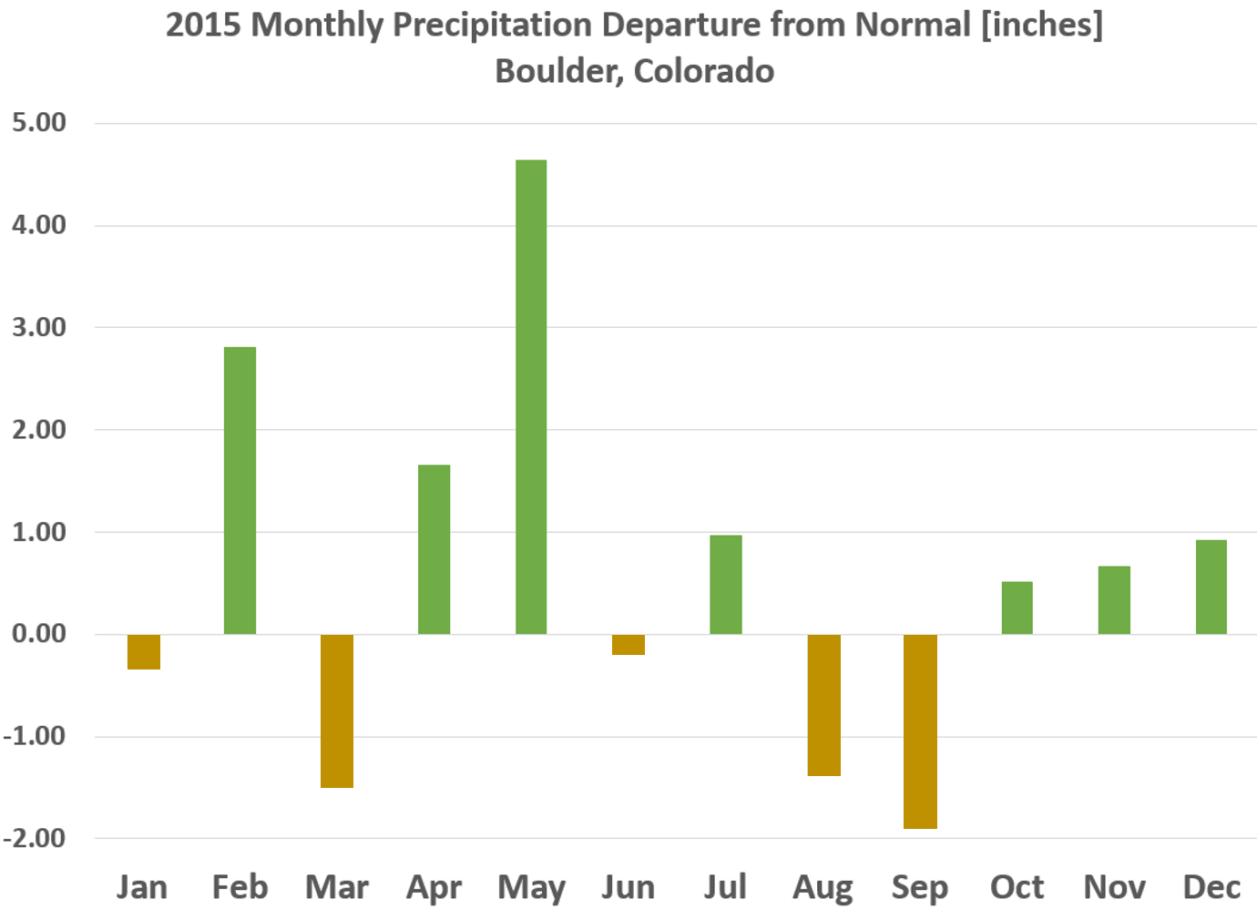
With a year having that much snow, it is not at all surprising that we also ended up as the 11th wettest year, finishing 2015 with 25.74″” of precipitation (more than 5.5″ above average).
2015’s precipitation distribution by month is seen below.
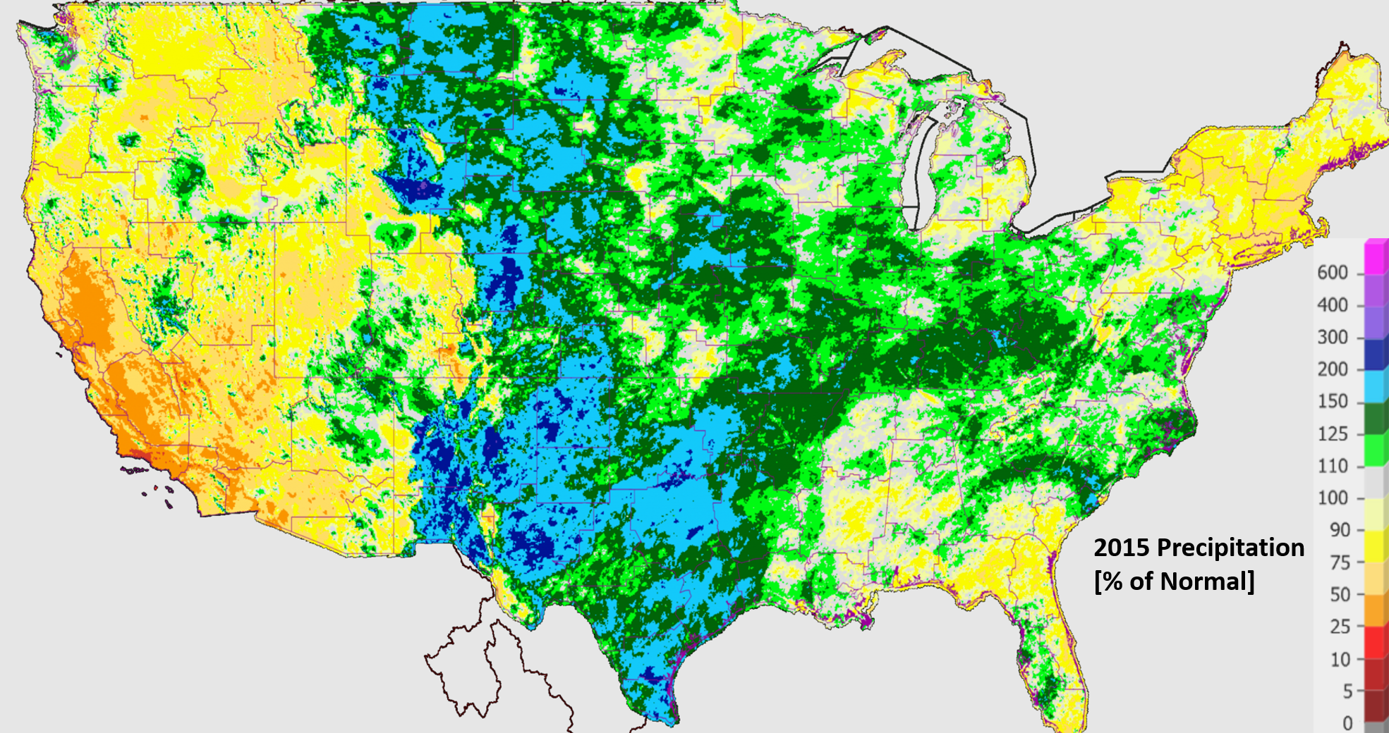
After one of the wettest spring seasons in Boulder’s history, the summer monsoon left us disappointed, despite the climatological enhancement we would normally expect from El Niño. By mid-July, the possibility for 2015 to become the wettest year on record was very real. However, the last half of summer destroyed that potential outcome. Then, in September, two years after the devastating flood of 2013, the clouds only mustered up 0.14″ of rain in Boulder, good enough to become the 12th driest September in the books. We ended the year with three consecutive months of above average precipitation, but it wasn’t enough to set the annual record. Regardless, most of eastern Colorado ended up fairly wet. As it happens, maybe one of the wettest places in the entire USA (at least as far as percentage of normal is concerned).
Despite the drier end to the year, 2015 allowed all of Colorado to dodge what looked like the beginnings of another drought in some parts, and to have a nearly non-existent wildfire season. Sure, we had to breathe in plenty of smoke this year, but that was mostly from fires burning in the Pacific Northwest.
Earth was warm. We were, too.
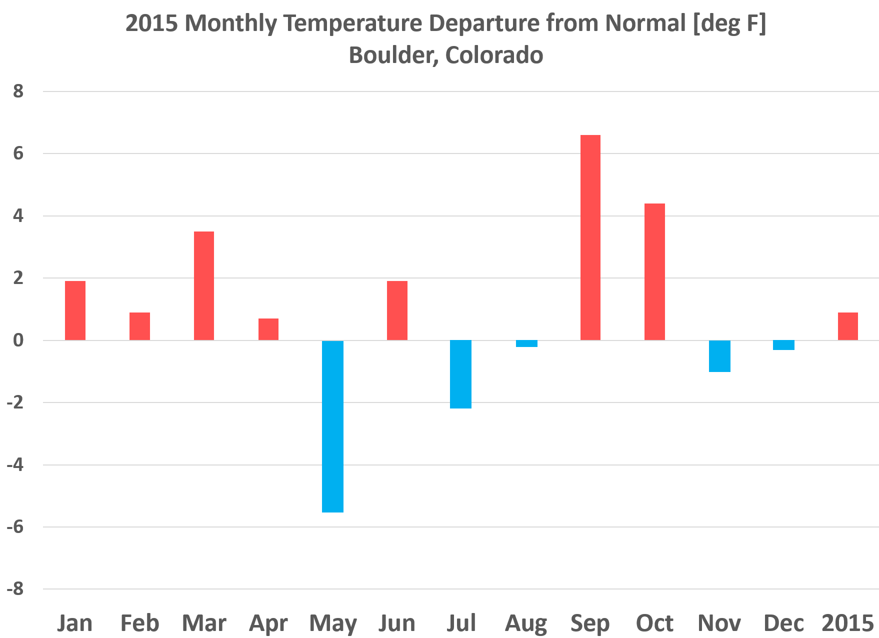
According to the National Climatic Data Center, 2015 will go down as the warmest year yet for planet Earth, some 2.4 degrees Fahrenheit above the average for the last century. Colorado ends up about 1.5 degrees above normal. Warm, but not enough to even make our top ten. Boulder concludes the year about 1.0 degree above normal (the final numbers aren’t in yet). This will put 2015 near spot 20 for warmest years. The graph below shows the temperature anomaly by month for 2015 in Boulder.
With a troughing pattern this summer, Boulder had below average temperatures in July and August, dodging the hottest weather of the year. We didn’t even reach 100 degrees at all, though we still sizzled to the 90-degree mark on 35 occasions, slightly above the normal of 31.
Our warmest temperature, 96 degrees, occurred on both August 15th and August 30th. Our coldest temperature, and only morning below zero was February 27th, with a chilly temperature of -1.
Rare Severe Weather Event
In early June, Mother Nature set the stage for a rare, multi-day severe weather event in Boulder County. Supercell thunderstorms can easily spin up from Denver eastward, but with our close proximity to the mountains, Boulder is mostly immune to such occurrences, making this situation quite a rarity. On the evening of June 4th, an EF3 tornado developed just north of Longmont. This was the first tornado in Boulder County since 1997, and the first F3 tornado ever observed in the county. Fortunately, it rolled through farmland and no one was injured. The same night, hail ranging in size from golf balls to tennis balls fell along a line stretching from Longmont to Lyons. Be sure to read our post recapping the historic, westward-moving supercell!

June 4, 2015 EF3 tornado, just north of Longmont.
Godzilla El Niño
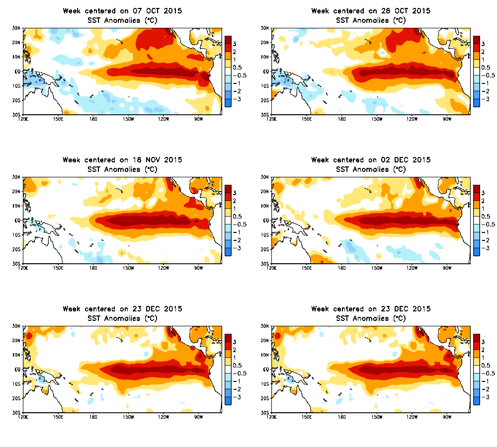
The forecasted and mega-hyped El Niño actually did show up to the party. However, it didn’t bring it’s A-game in 2015, at least for our neck of the woods. We have yet to truly see any sort of “typical” El Niño pattern set-up this fall, lacking the more pronounced southern storm track. Though, in our last forecast, we did mention that changes may finally be on the horizon.
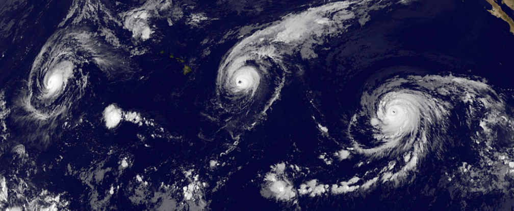
One clear and direct impact of this year’s El Niño was in the Pacific Ocean’s hurricane season which was aided by warm ocean temperatures and reduced wind shear. A staggering amount of records were set, including the formation of the strongest hurricane ever to exist in the Western Hemisphere (Hurricane Patricia / 200mph / 879 mb pressure), which explosively intensified just off the Mexican coastline before making landfall in a rural area. Though no storms made landfall in Hawaii, it looked ominous for a while there, with storms popping up all over the central Pacific, a typically hostile environment for hurricane development.
Over in the Atlantic, El Niño has the opposite effect, causing increased vertical wind shear which inhibits cyclone formation. Our tropical expert, Matt Steiner, made a forecast for a below average hurricane season in the Atlantic Basin, which did verify, despite the very early formation of Tropical Storm Ana in the first week of May. There were only 12 named storms, including four hurricanes, including Hurricane Joaquin, which briefly gave about 20% of the United States’ population a major scare before heading out to sea.
El Niño remains at it’s strongest right now (which by the way, still isn’t as potent as the 1997 one), but weakening is projected over the next month. It will persist at least into late spring. The biggest impacts from El Niño across the American West typically occur during the heart of winter and early spring (though we showed a fairly significant relationship with big October snows in Boulder). Look for El Niño to become more of a player in early 2016.
Animation showing the development of El Nino from the Jason-2 Satellite throughout 2015. Click to animate (if it isn’t already)
Around the globe
The Earth’s is far too large and diverse for us to mention everything in the weather world here. We didn’t cover much of this content in detail on the site, but if it piques your interest, hit up Google for more information, or listen to our discussion in some of the podcasts on these topics.
- FEBRUARY: Weather world went crazy over Boston’s setting all-time seasonal snow record with 110″. Fun fact: Boulder had 118″, and the Priuses still didn’t slow down!
- APRIL: Calbuco Volcano erupts in Chile
- MOST OF THE YEAR: Record heat and extreme drought plague Western USA for most of 2015, limiting snowpack and contributing to the next point
- JULY – SEPTEMBER: Wildfires burn rampant across the west, particularly California, Oregon, and Washington. Several states saw their largest and most destructive fires ever.
- SEPTEMBER: Two tropical cyclones form in the Arabian Sea, making unprecedented landfalls in Yemen just a week apart
- OCTOBER: Extreme flooding in the Carolinas as a result of Hurricane Joaquin’s moisture over-riding a stalled front
- DECEMBER: U.S. nearly had the lowest annual tornadic death toll on record, but last weekend’s outbreak in Texas tragically took 2015 way out of contention
—–
As always, thanks for reading! Continue spreading the word about our site and look for many more great products and forecasts from BoulderCAST in 2016! Happy New Year!
P.S. We have received several requests to organize a meet-up/happy hour type event with good beer, and even better weather discussion. It is now in the works for early 2016. More details on this are coming soon. For now, if you have any questions, comments or concerns, be sure to hit us up via email at contact@boulercast.com.




I looked and looked to find out how strong that Longmont tornado was and your site is the first one to classify it. Awesome! I assume that’s the official rating? Where did you find that?
Interesting. It is odd that now looking I also can’t find much information on the classification. However, I have the screencap from the original storm survey done in the linked post. Showing the track of the tornado and strength at each point based on damage.
http://www.bouldercast.com/a-look-back-last-weeks-severe-weather/
Were you near the storm? Did you get any photos?
Update: Here is a new article mentioning EF3 as well.
http://denver.cbslocal.com/2015/06/07/berthoud-tornado-strongest-in-nearly-a-decade-rated-as-one-of-colorados-rarest-twisters/
Ah – thanks for that. Holy cow – had no idea it was that powerful.
Ha – I checked out the other blog post just now, and ironically I’m ‘gcgoods’ from that YouTube video (thanks for the embed!). I have another video of it from my handheld camera and a few good stills from my cameras:
https://www.youtube.com/watch?v=fv3M3WZiwEs
https://www.facebook.com/greggoodson/posts/10101354695875529
Reading everything about this storm and the tornado it produced, I’m realizing more and more how lucky I was to see it almost from start to end. It was something to behold.
Just came across your site / podcast only just today. Good stuff!
Wow, that is awesome. Thanks for sharing. Small world. 😛
Unfortunately, I was in Wyoming for both days of this event. Though did get to see golf ball sized hail off of I-80 near Cheyenne.