The first two storm systems of the season capable of producing snow across the lower elevations mostly missed the mark, with only a small portion of the Denver Metro area reporting snow so far this season. Neither Boulder or Denver have officially received any snowfall since April. That will definitely change this week, perhaps as early as Sunday night as a light round of rain changing to snow is expected. Furthermore, a complicated, unsettled weather pattern will unfold the rest of the week in Colorado keeping our temperatures well below normal with almost daily chances for more rain and snow. We’re fairly confident everyone will see additional light accumulating snow Tuesday night into Wednesday, with a potential for a more impactful storm late in the week into the weekend, including possible blizzard conditions. We truly have a lot to cover in this week’s outlook, so let’s dive in!
At a Glance
- Rain to Snow Sunday Night into Monday Morning: A closed low pressure will pass across New Mexico with chilly upslope and a cold front producing rain/snow for our area. There will be a sharp gradient in precipitation amounts, highest in and near the Foothills.
- More Snow Tuesday Night into Wednesday: A second storm will drop across Utah on Wednesday clipping our in the area process with another round of very cold older upslope. This should lead to light snow for our entire area Tuesday night through much of Wednesday with light accumulations favored (dusting to 4″)
- Late-Week Blizzard Possible: A strong low pressure is likely to pass through eastern Colorado Friday or Saturday, potentially strengthening into a blizzard somewhere on the Plains. The exact track remains uncertain, with impacts here ranging from just a little rain/snow to a full-on blizzard in the cards. The late-week forecast should be closely watched.
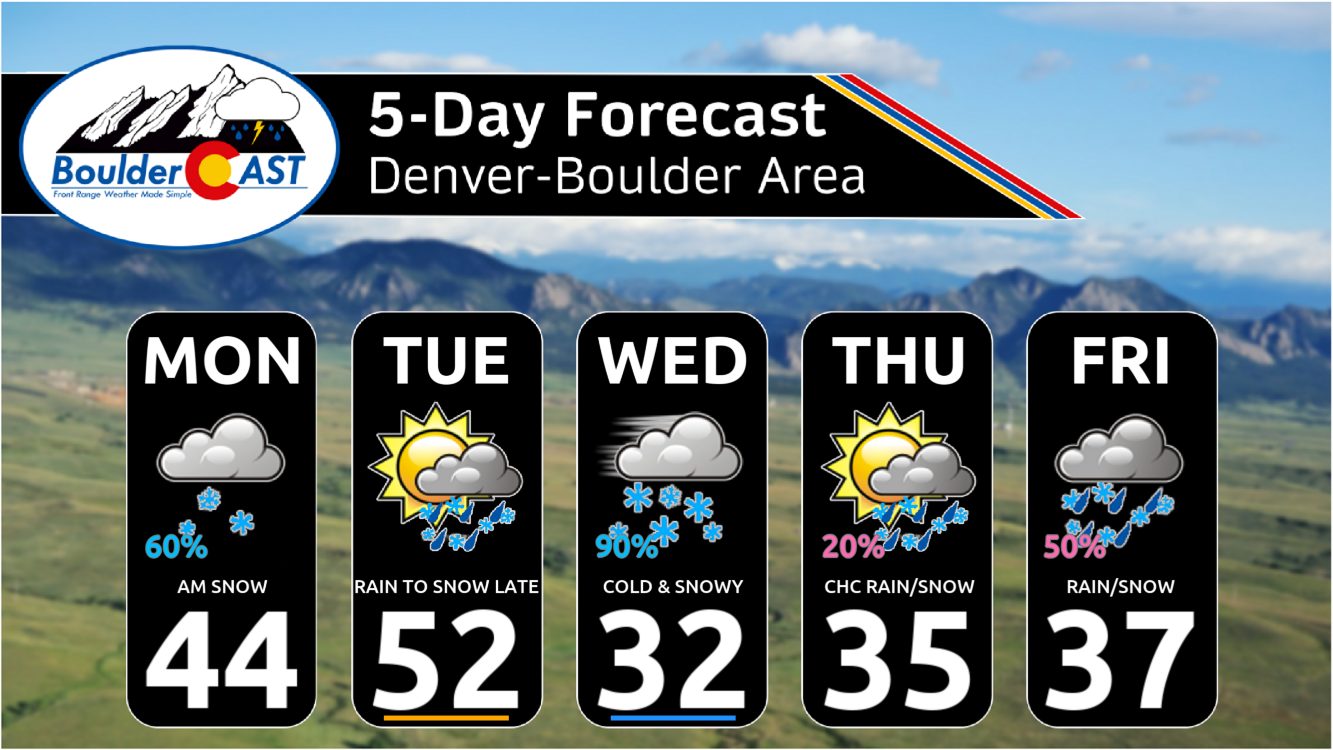
- Chilly Weather Lingers: Temperatures will remain below normal through the week ahead — warmest on Tuesday in the 50s, coldest Wednesday near freezing. Thursday into the weekend will be in the 30s to lower 40s.
Daily Forecast Updates
Get our daily forecast discussion every morning delivered to your inbox.
All Our Model Data
Access to all our Colorado-centric high-resolution weather model graphics. Seriously — every one!
Ski & Hiking Forecasts
6-day forecasts for all the Colorado ski resorts, plus more than 120 hiking trails, including every 14er.
Smoke Forecasts
Wildfire smoke concentration predictions up to 72 hours into the future.
Exclusive Content
Weekend outlooks every Thursday, bonus storm updates, historical data and much more!
No Advertisements
Enjoy ad-free viewing on the entire site.
Third time is the charm?
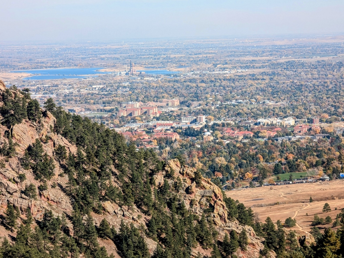
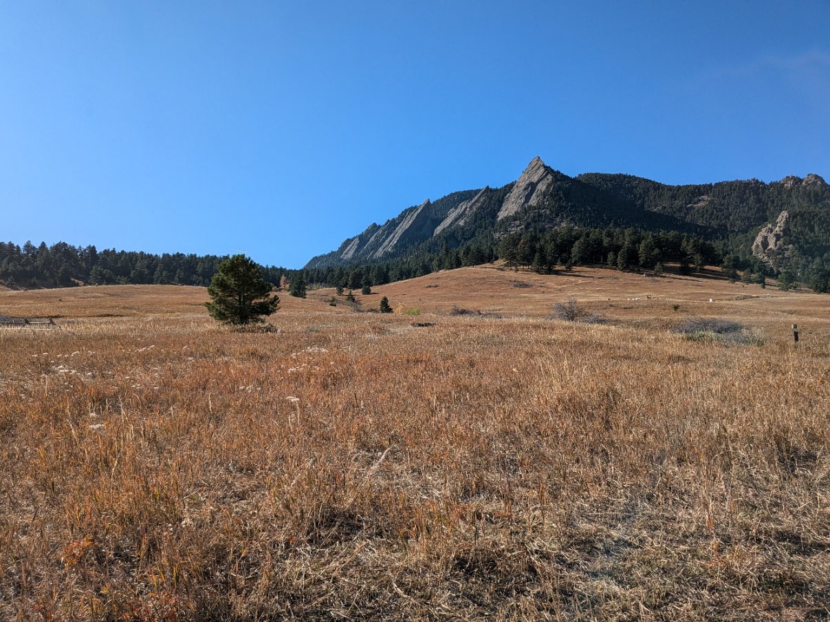
It was a beautiful Saturday across the region with high temperatures in the 60s under completely sunny skies. We hope you were able to get outside and enjoy it! I personally ventured up Green Mountain in Boulder. There was a bit of accumulating graupel near the top near 8000 feet elevation, still unmelted from last Thursday’s storm. Otherwise, conditions were excellent and the views of Boulder even better. Foliage is definitely past its peak, but there are still some muted colors to be found.
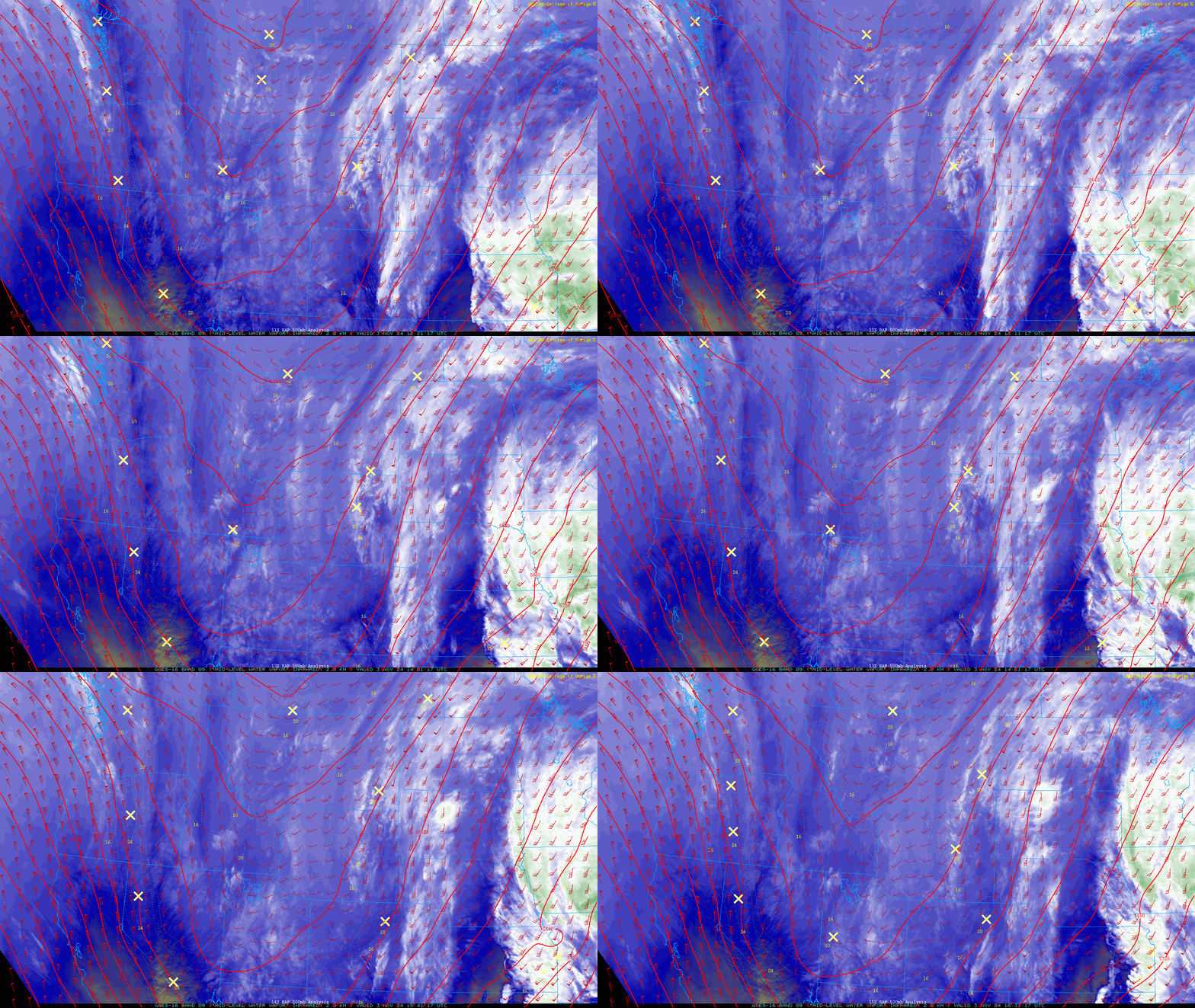
The nice weather will be short-lived, however, as our next storm system is already entering the area from the west, part of a larger pattern shift we’ve been discussing which is ushering in more seasonally-appropriate weather to our area beginning last week. As seen in the GOES-East water vapor animation below for Sunday morning, a broad trough is slowly dipping into the Intermountain West.
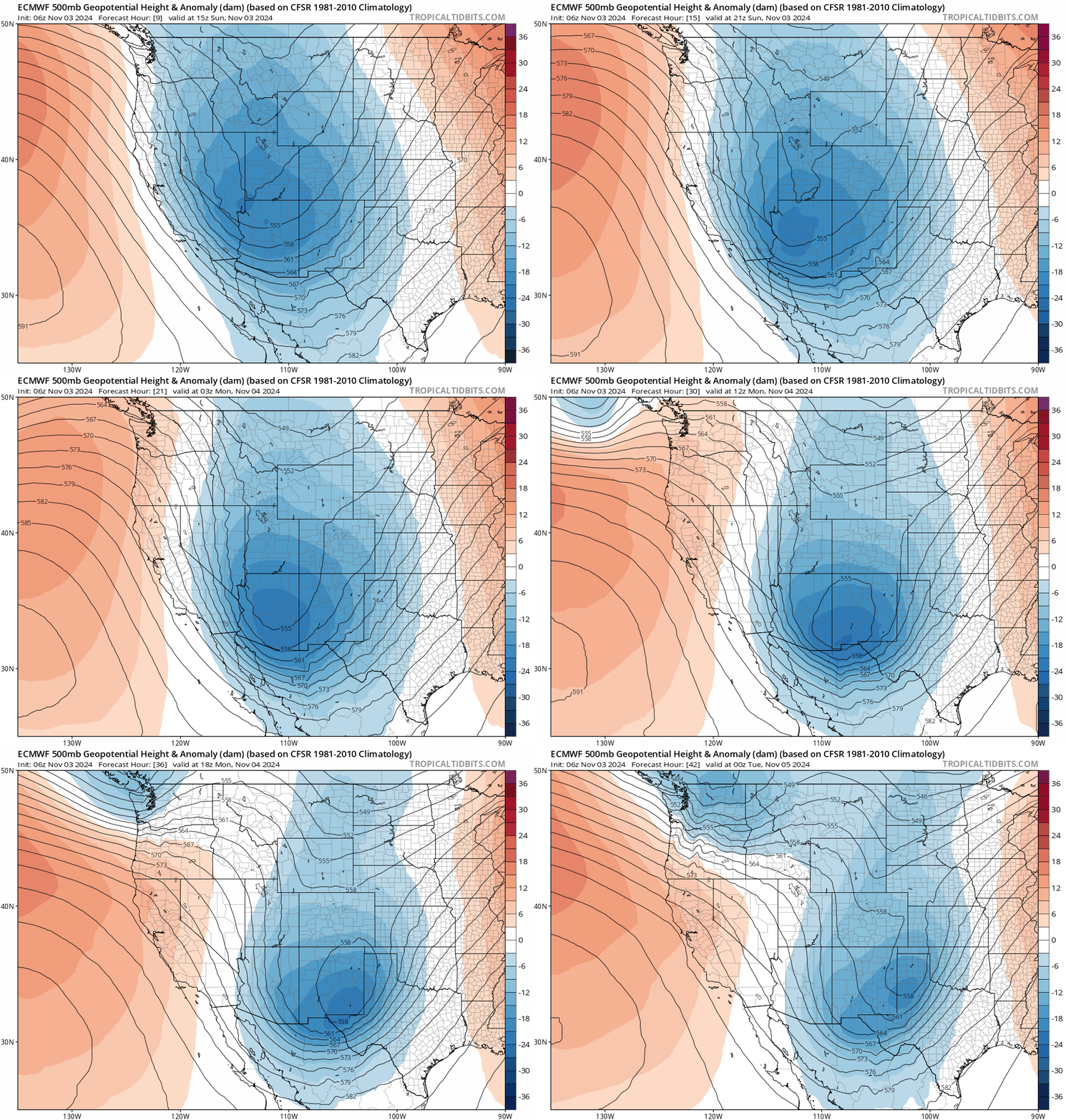
Over the next 12 hours or so, a piece of energy will consolidate along the southern tier of this trough, forming into a cut-off low southwest of the Four Corners. This low will then move east across New Mexico Sunday night into Monday before exiting the area Monday night. Check out the track of the developing cut-off low in the European 500mb forecast below:
Similar to our last two (or three?) storms, this track is once again too far south to bring major impacts to the Front Range. However, there will be a period from Sunday afternoon into late Monday morning when precipitation will be possible to likely across the Front Range area. Sunday afternoon will see instability snow showers form across the Mountains, some of which could produce snowfall rates of 1-2″ per hour during the afternoon and evening. Expect winter weather if you are driving in the Mountain passes later today, especially around Rocky Mountain National Park! Further east in the Metro area, things are already starting to turn cooler as the preliminary cold front has moved through overnight. There will be just a few rain showers around through the day Sunday with highs in the 50s. Overall, Sunday will still be fairly nice if you can mind the slightly cooler temperatures and thickening clouds.
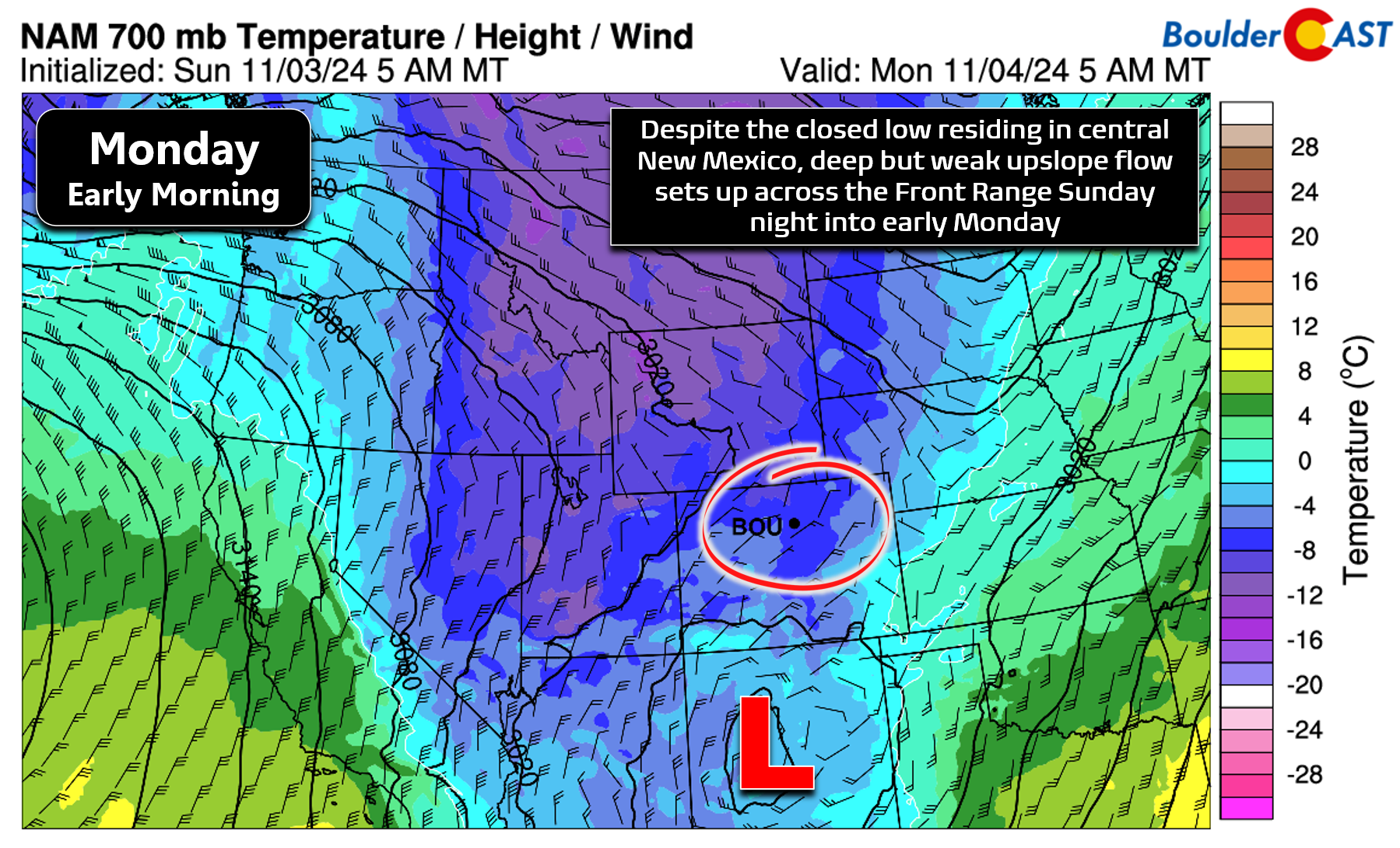
As we head into late Sunday, a secondary cold front will drop across the Metro area with upslope flow on its backside. This front, combined with the upslope, will aid in spreading more substantial precipitation east of the Continental Divide and into the Boulder-Denver area. Precipitation will begin as rain across the lower elevations Sunday evening, but should mix with or change-over to snow Sunday night in most areas. The change-over to snow will rely on the formation of heavier showers to aid in dynamic and evaporative cooling to get us down into the lower 30s, at least early on. By early Monday morning, sufficient cold air advection will have taken place, allowing for everyone to get cold enough for snow — though at that point, the forcings will be waning with precipitation on a steep decline.
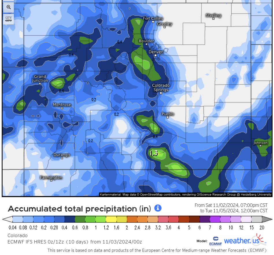
Most guidance forms a bulk of the heavier precipitation in and near the Foothills Sunday night into early Monday, including around Boulder and Golden. The latest Euro precipitation forecast for Colorado through Monday evening shows that greater than 0.5″ of moisture is possible in the Foothills and along the Continental Divide:
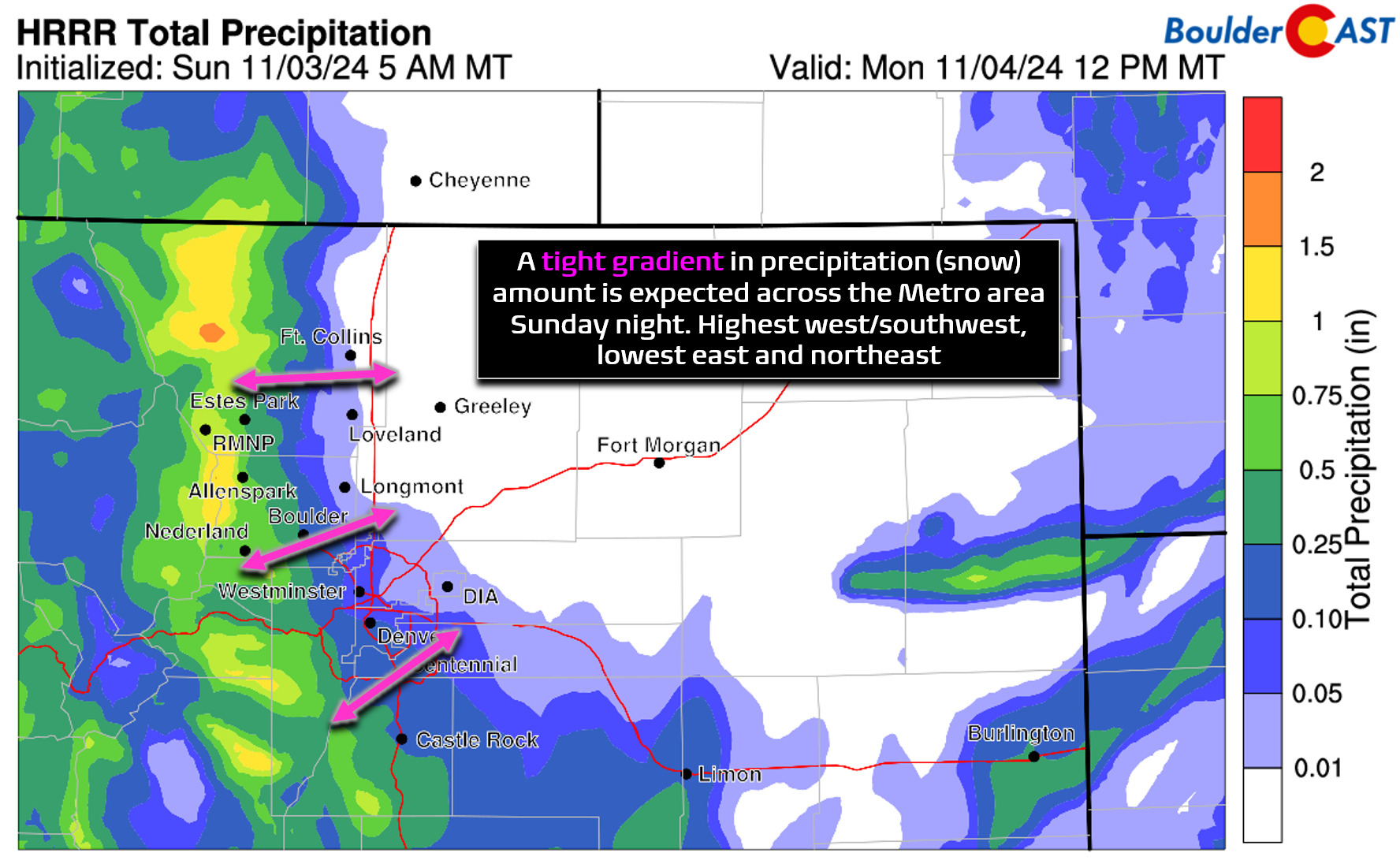
Short-range guidance also indicates this classic upslope signature across the Front Range, with a strong gradient of almost no precipitation at Denver International Airport pushing above 0.5″ in the Foothills. Boulder should land somewhere in the middle between 0.2 and 0.4″
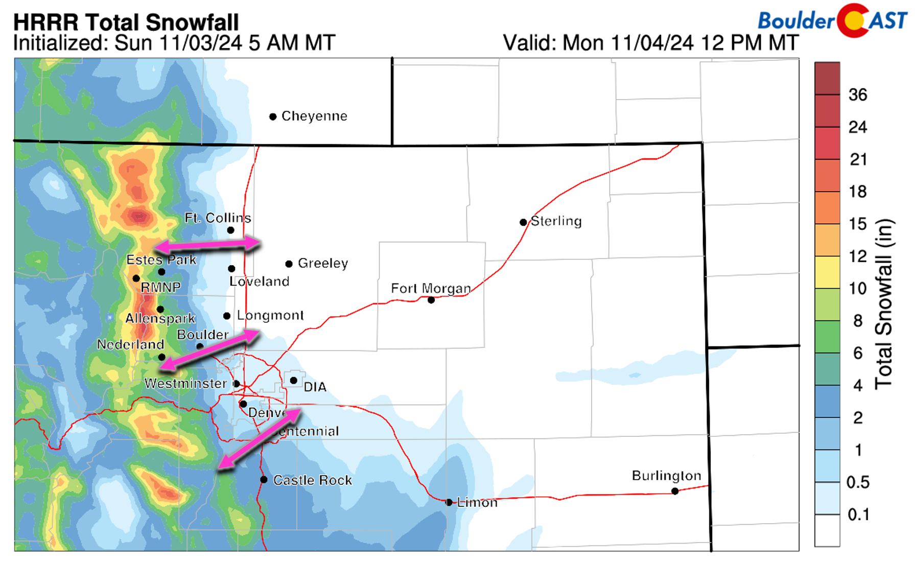
This will mean the best chance of accumulating snow tonight will be in the western and southern suburbs, and in the Foothills and Palmer Divide, where a bulk of the action will reside. Precipitation will be lighter (and warmer) for areas east of I-25 and snow accumulation may be limited or non-existent there.
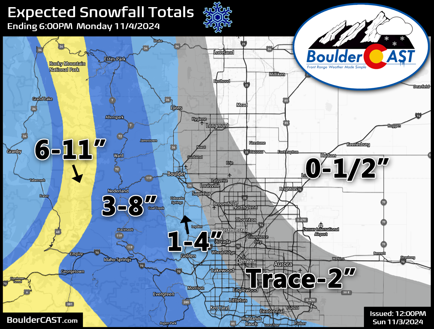
Sadly, the first snow of the season isn’t 100% guaranteed for our area again with this event. It looks quite likely that our western and southern communities will see some wet snow stick tonight, while areas further east may miss out once again. Our official snowfall forecast map for this Sunday into Monday storm is shown below. We expect most of the Denver Metro area to receive between a trace and 2″ of snow, with up to 3″ right near the base of the Foothills (far western Boulder, Golden, Rocky Flats). Up to 8″ is possible in the higher Foothills above 8000 feet where it will be colder and precipitation is expected to be more intense/widespread. Areas like Longmont and DIA may see no snow (or even no precipitation) at all.
Our latest Snowfall Probability Charts tell a similar story to our forecast map. Boulder stands a pretty good chance to see 1-2″ of snow, but not much more with this system. The rest of the lower elevations are unlikely to exceed 1″.
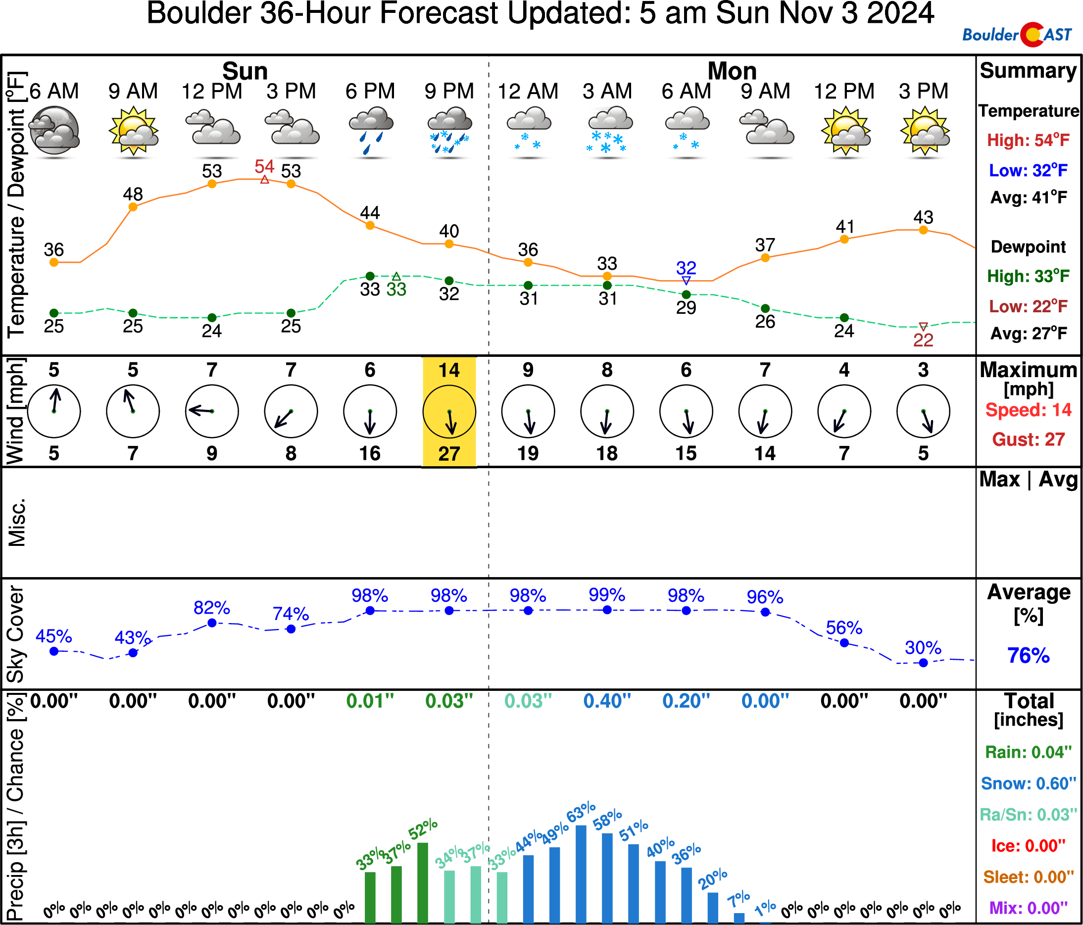
Look for temperatures to stay in the 50s throughout the daytime hours on Sunday, quickly falling into the 40s and 30s this evening. We could start to have snow mix in after 9PM in areas that see more intense rain showers. Otherwise, most of the Metro area will slowly transition to light snow after midnight but before sunrise Monday as deeper cold air filters in from the north and surface temperatures drop towards the freezing mark.
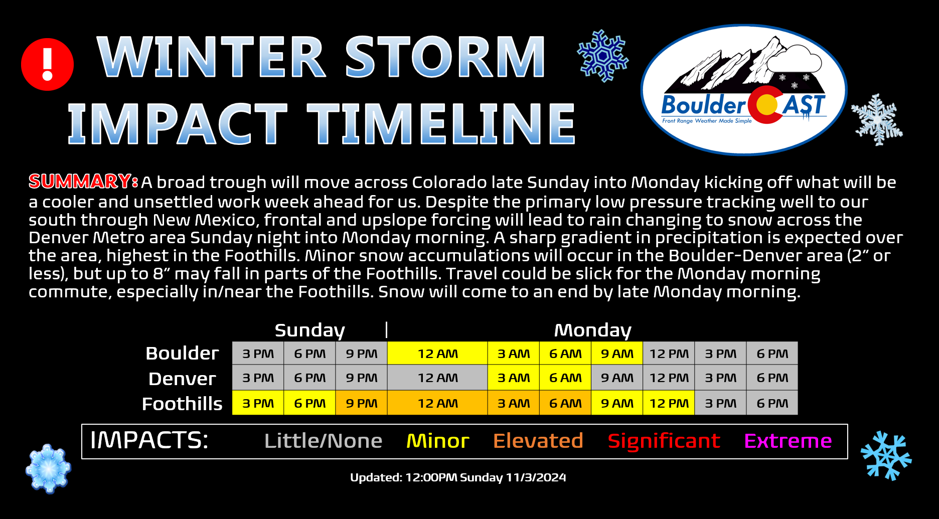
Monday morning’s commute should be mostly fine in the Denver Metro area as pavement temperatures remain warm, though there may be some isolated slick spots in the far western/southern suburbs. Keep in mind that the first accumulating snow of the season is always pretty wild on the roadways here, with many procrastinating drivers still running summer tires and some seemingly forgetting that snow is indeed slippery. Our Storm Impact Timeline shows the timeframe for mostly minor travel impacts:
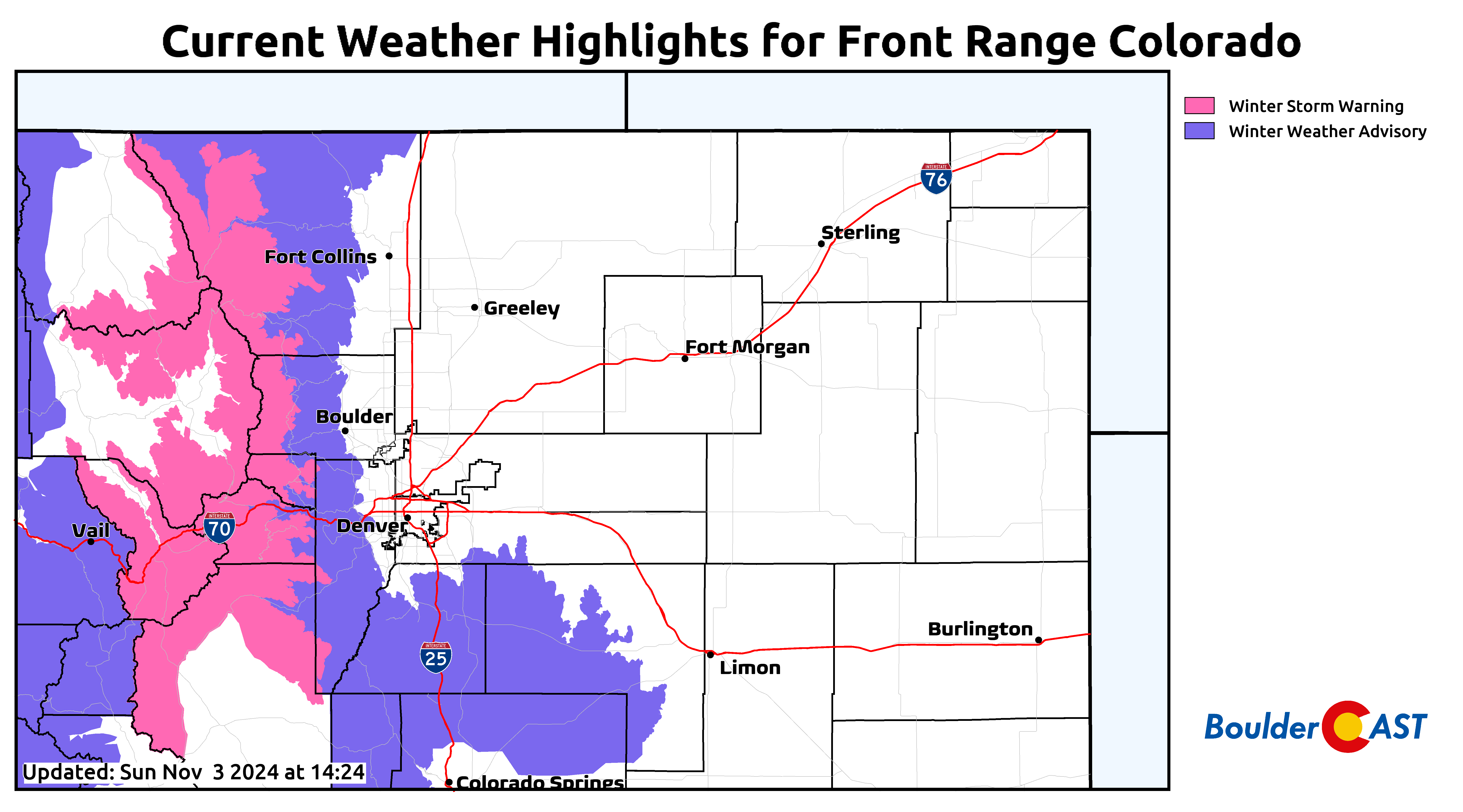
Roadways will be slicker and snowier across the higher terrain where Winter Weather Advisories (Foothills & Palmer Divide) and Winter Storm Warnings (Mountains) are posted. Conditions will start to deteriorate as early as Sunday afternoon in these higher elevation areas.
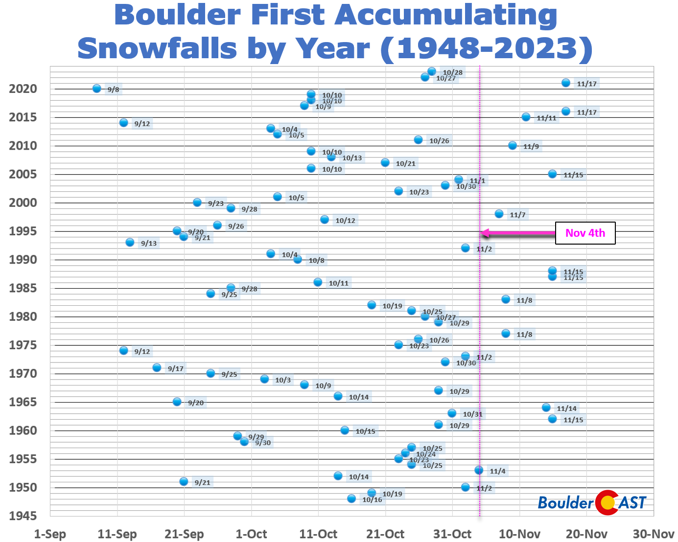
We still await our first accumulating snow of the year in Boulder, but as we’ve discussed above, maybe not for long! There’s a pretty good chance that our 2024 First Snowfall Contest will wrap-up in the next 24 hours. You can find a breakdown of all the entries HERE. If our first snow does indeed occur later tonight in Boulder, this would be tied for the 14th latest first snow since 1948.
The week ahead: Staying unsettled with additional snow likely
The weather for the rest of the week will remain cool and active across the Front Range thanks to a secondary cut-off low pressure expected to form Wednesday morning in eastern Utah. You can see tonight’s storm departing eastward in the animation below, but notice the secondary one immediately dropping into the Four Corners in its wake. This follow-up low pressure has our team very interested, as it will linger across the Four Corners area for several days before eventually kicking out across Colorado late in the week.
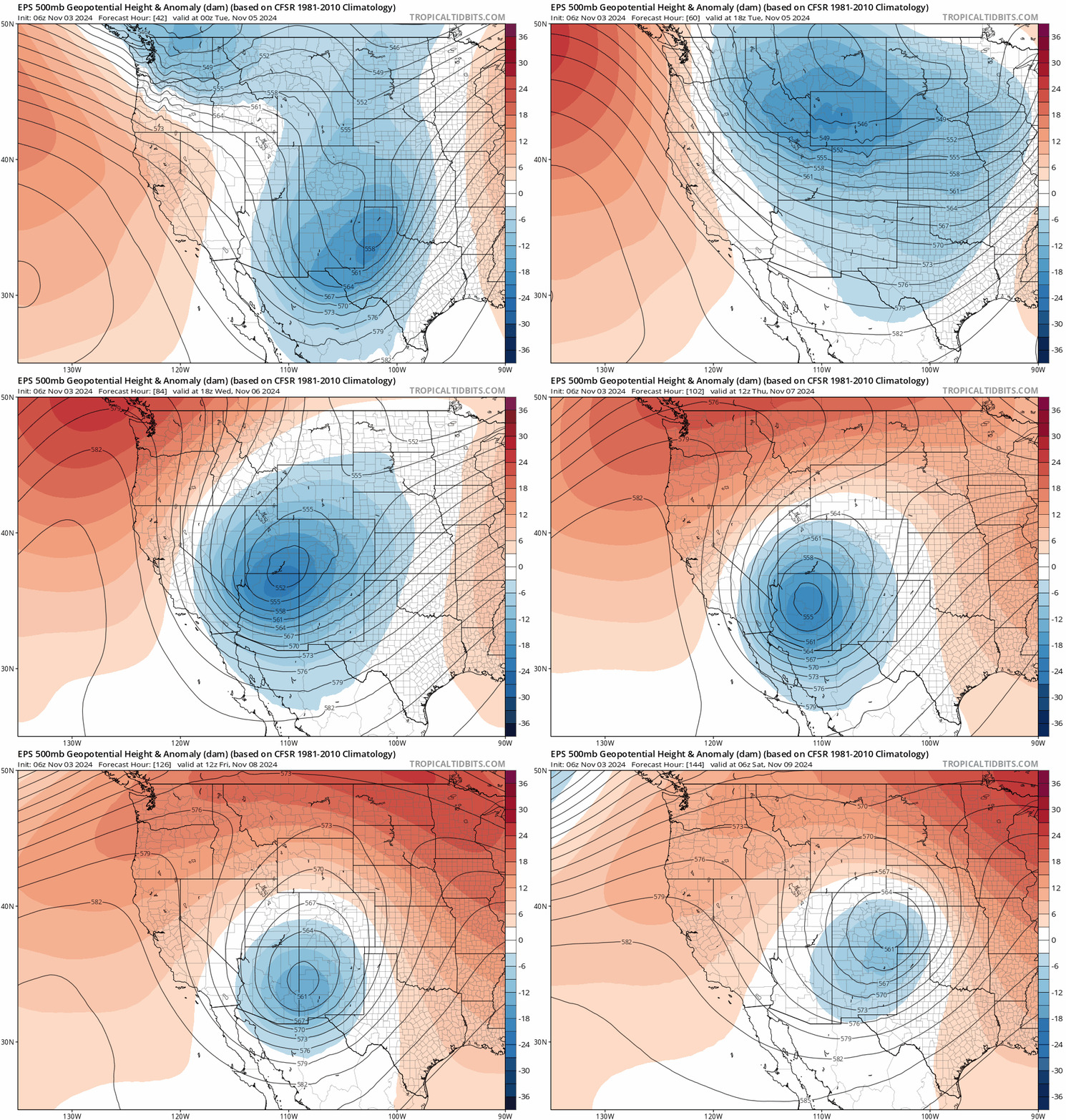
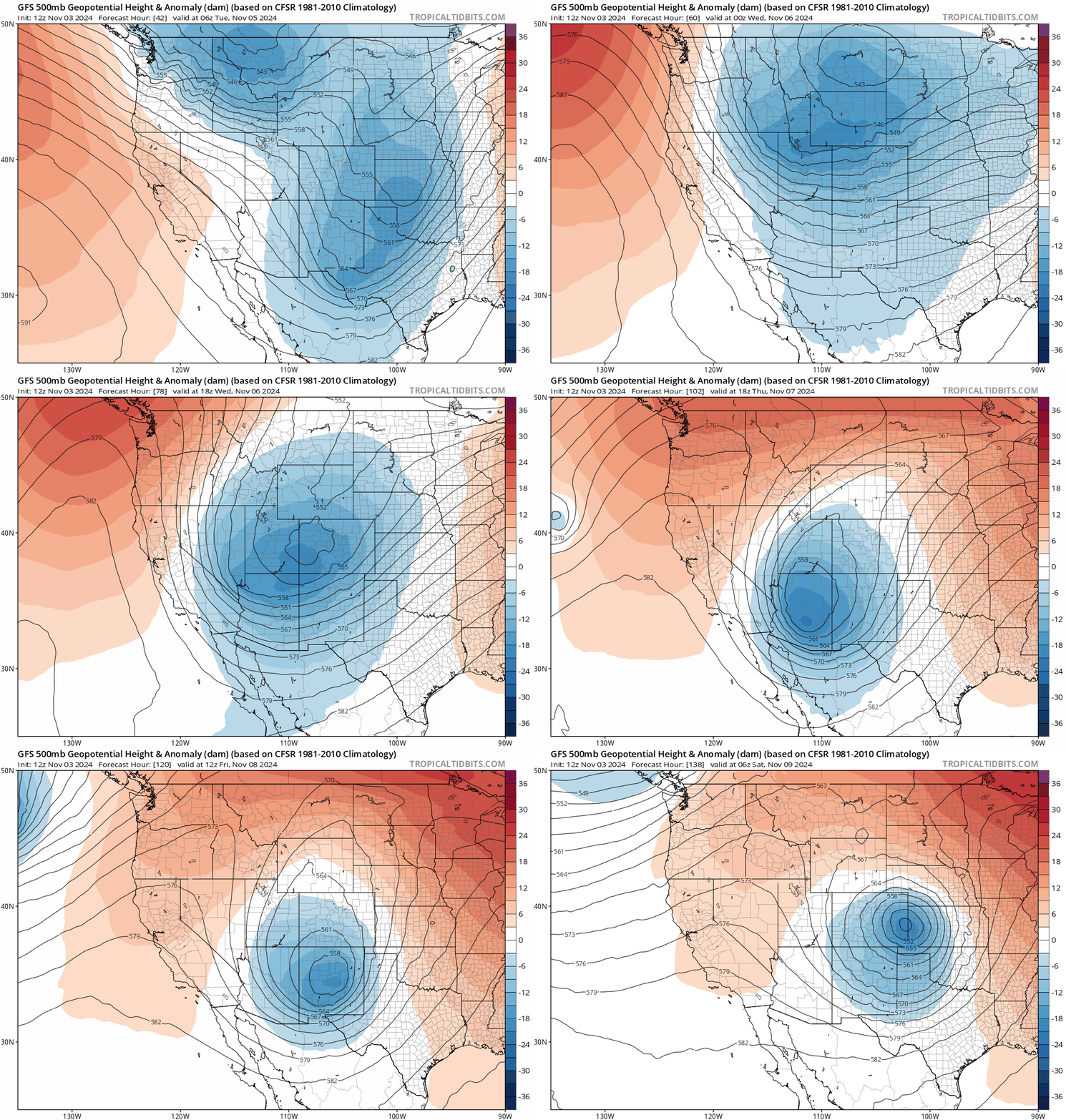
That fact that it dives so far south into Arizona and New Mexico doesn’t favor our area in general. However, most ensemble guidance agrees that the storm will kick out into eastern Colorado by Friday or Saturday. The European ensemble mean solution (above) aligns fairly well with the GFS ensemble mean (below), though the GFS has a much stronger low in eastern Colorado by Saturday morning. A stronger, tighter storm isn’t necessarily better as it could lead to more downslope for us (and nasty blizzard conditions out east).
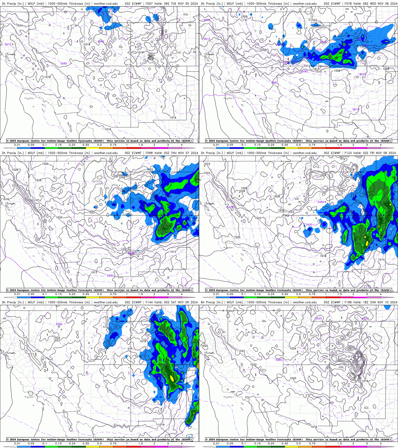
Exactly how this low pressure evolves from Wednesday through Saturday will determine the slew of impacts we see here in northeast Colorado. In general, we will be looking at an extended period of chilly temperatures with intermittent rain/snow beginning Tuesday night, likely lasting into the weekend. The European model’s 6-hour precipitation forecast is animated below. As an example of the prolonged unsettled weather, this model has nearly continuous chances for rain/snow most of the week.
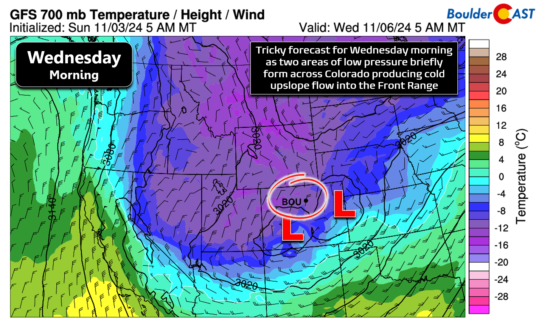
Our initial concern will be for a round of widespread snow Tuesday night through Wednesday as the low pressure drops across eastern Utah, making its closest approach to the area for the time being. Some form of low pressure will develop in the lower levels in Colorado, forcing another cold front to drop south with upslope enhancement in the Denver Metro area, this time with even colder air to work with. 700mb temperatures are forecast to drop below -10°C Tuesday night into Wednesday — certainly cold enough for snow across the entire area, if we can manage to squeeze out some precipitation during this timeframe. Expect high temperatures Tuesday in the low to middle 50s, but with an abrupt cold frontal passage late in the day with rain quickly changing over to snow in the evening. It’s still early, but there’s plenty of model support for 1-4″ of additional snow accumulations Tuesday night into Wednesday evening for Boulder and Denver, with higher amounts in the Palmer Divide and southern Foothills. Wednesday will be a very cold day with overcast skies, intermittent light snow through the day, and highs only around the freezing mark. The colder airmass should also allow for greater travel impacts, even with only light snow accumulations, as snow will have better luck sticking on the roadways.
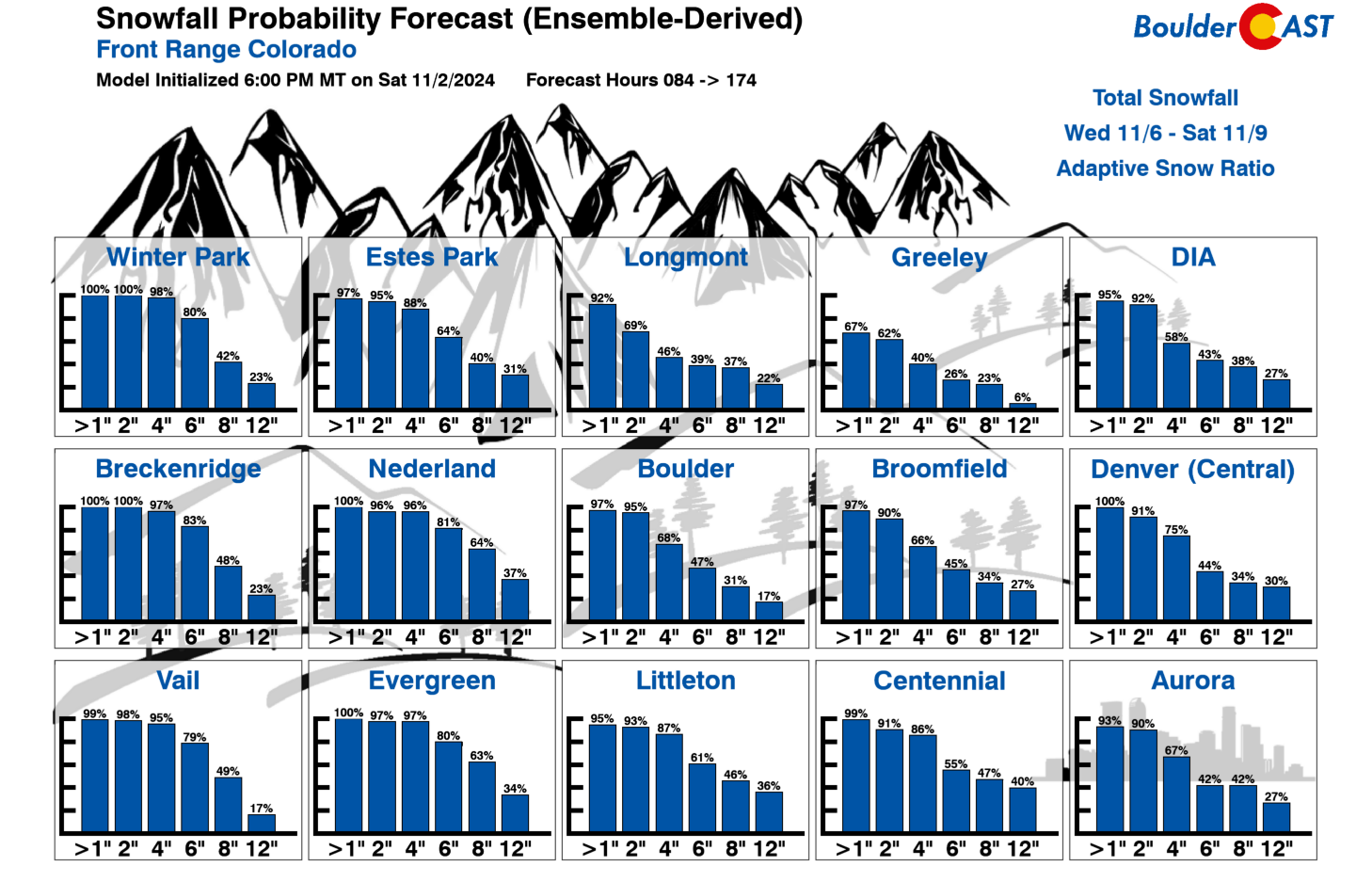
Thursday and Friday will remain chilly with subsequent chances for rain and snow across the area. High temperatures will likely be in the mid to upper 30s both days. Thursday looks to be somewhat drier as the stalled mid-level low pressure will be sitting far away in Arizona at this time. We still could see a few sporadic rain/snow showers Thursday, with the best odds south of Denver. Friday will see the low pressure draw closer across New Mexico and it should lead to an uptick in rain/snow chances, especially heading into Saturday. We can’t stress this enough — there is a lot of uncertainty in our weather late week so we won’t make any specific forecast for timing or snow amounts quite yet. Just be aware that it is looking increasingly likely there will be a strong storm spawning across eastern Colorado by Friday or Saturday, one which would tap into a deep fetch of Gulf of Mexico moisture, with potential blizzard conditions developing somewhere east of the Mountains. Temperatures will be creeping back up late week a tad, thus making mixed precipitation more likely than pure snow. The Snowfall Probabilities below are for the period of Wednesday through Saturday. Our entire area will have excellent odds to see a few inches of accumulating snow through the extended period, with 20 to 30% chances of a FOOT or more. Those high-end amounts would rely on that aforementioned late-week storm targeting Denver, which remains nebulous at best at the moment.
For now, plan on much colder week with unsettled conditions each and every day. Be sure to follow us on Twitter, Facebook, and Threads for smaller updates in the coming days, or subscribe to get notified of these long-form posts. This should be an intriguing week in Colorado weather! Stay tuned…
Forecast Specifics:
Monday: Lingering light snow in the morning hours with minor impacts on the morning commute, mainly in and near the Foothills and Palmer Divide. Skies will become partly cloudy with highs in the lower 40s on the Plains with middle 30s in the Foothills.
Tuesday: Mostly sunny early with increasing clouds late in the day. High temperatures reach the lower 50s on the Plains with lower 40s in the Foothills. Rain showers will develop around sunset changing to snow quickly in the evening and continuing overnight.
Wednesday: Much colder with light snow on and off through the day, mainly south and west of Denver. High temperatures will only be around freezing on the Plains, with low to middle 20s in the Foothills. Low end accumulating snow is expected for the entire Front Range (1-3″?)
Thursday: Skies will be partly to mostly cloudy with a slight chance of rain/snow showers through the day. Highs only in the upper 30s on the Plains with upper 20s in the Foothills.
Friday into the Weekend: Continued overcast with chances of rain/snow. The forecast remains uncertain but increasing confidence for a strong storm across eastern Colorado Friday into the weekend. It may hit the Denver area, or could mostly miss us south and east. Time will tell but keep a close eye on this as impacts COULD be substantial.
Get BoulderCAST updates delivered to your inbox:
DISCLAIMER: This weekly outlook forecast is created Monday morning and covers the entire upcoming week. Accuracy will decrease as the week progresses as this post is NOT updated. To receive daily updated forecasts from our team, among many other perks, subscribe to BoulderCAST Premium.
Daily Forecast Updates
Get our daily forecast discussion every morning delivered to your inbox.
All Our Model Data
Access to all our Colorado-centric high-resolution weather model graphics. Seriously — every one!
Ski & Hiking Forecasts
6-day forecasts for all the Colorado ski resorts, plus more than 120 hiking trails, including every 14er.
Smoke Forecasts
Wildfire smoke concentration predictions up to 72 hours into the future.
Exclusive Content
Weekend outlooks every Thursday, bonus storm updates, historical data and much more!
No Advertisements
Enjoy ad-free viewing on the entire site.
Enjoy our content? Help us out and give it a share:





You must be logged in to post a comment.