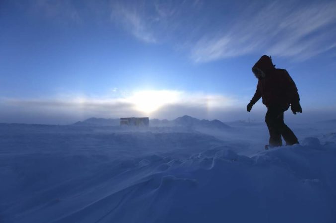
Significant weather changes are headed to the area over the next 12 to 48 hours with our second winter storm of the season taking aim on the Front Range. That’s right…don’t forget we had snow seven long weeks ago! This system will pack record-setting cold for late-October as well as widespread fluffy snowfall and embedded heavy snow bands compliments of the overhead jet stream. In this winter storm update, we discuss when the snow will arrive, how much accumulation to expect, and just how cold it will get to shatter existing records.
At a Glance:
- A strong storm system will dive southward through the Rockies bringing a bitter cold Arctic airmass and snow to the Front Range Sunday into Monday
- Pre-storm, gusty winds in the higher terrain during the day Saturday will lead to high fire danger and continued growth of existing fires
- The cold front will arrive around sunset Saturday night with temperatures falling off a cliff into the teens overnight
- Snow begins early Sunday morning and continues into early Monday
- Upslope will be limited with this storm, with the main lift for snow coming from the overhead jet stream
- Snowfall amounts of 4-8″ around Denver, 6-13″ in Boulder and the Foothills northwest.
Help support our team of Front Range weather bloggers by joining BoulderCAST Premium. We talk Boulder and Denver weather every single day. Sign up now to get access to our daily forecast discussions each morning, complete six-day skiing and hiking forecasts powered by machine learning, first-class access to all our Colorado-centric high-resolution weather graphics, bonus storm updates and much more! Or not, we just appreciate your readership!

General atmospheric setup
Not at all unlike what unfolded one year ago, October will wrap-up with a bitter cold and snowy stretch this year as well in the Denver Metro area. Our winter storm system is en-route to Colorado this morning, currently producing very cold temperatures and widespread snow upstream in Montana and parts of Wyoming. The main trough will sag slowly southward through Saturday and Sunday. Eventually a closed-low will pinch off into northern Arizona by Monday morning. The storm’s large-scale evolution over the next two days is shown in the animation below.
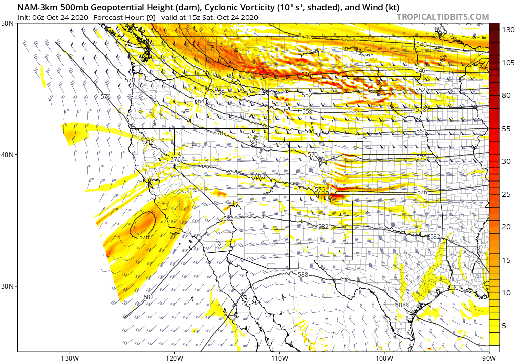
The track of the developing low has been getting further and further away from the Front Range in subsequent model runs over the last few days. It’s a little concerning that the primary core of the system is tracking so far to our west, but not overly so. The main trough and resulting upslope wind fields across the Boulder/Denver area were never going to be that favorable anyways. As we have been reiterating for six (!) days now, the primary forcing at-play with this storm system for our area is the overhead jet stream, and that is still very much aligning as it needs to. Both the subtropical and polar jet streams will be draped across Colorado for this snow event. The one to watch for our area in particular is the polar jet stream. Northern Colorado will reside in the right-entrance region of the polar jet for about 18 to 24 hours beginning early Sunday morning and continuing into Sunday night, as shown below. Jet forcing lingering that long in one area is not typical, but the result will be lots of snow despite the less-than-ideal storm track to the west.
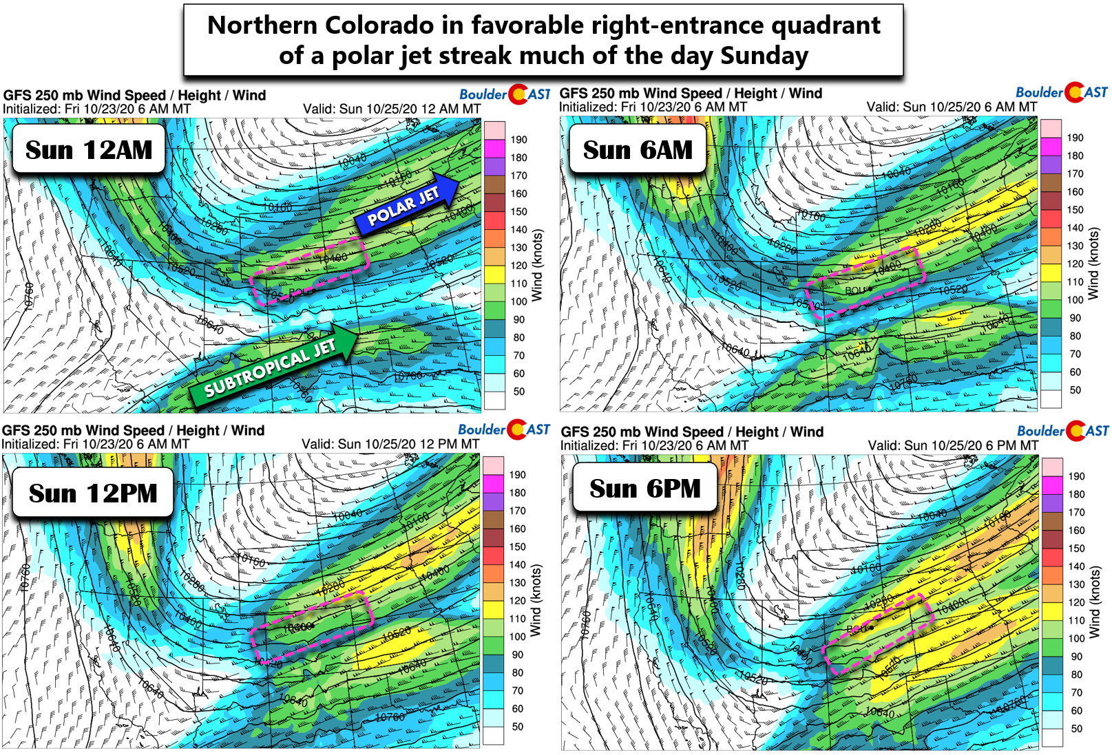
Northern Colorado being in this location will allow for the development of widespread jet-forced snow bands across the Front Range Plains, Foothills, and Mountains alike. At the same time, a strong Arctic cold front will be pushing through which will also add more lift into the mix to enhance snowfall rates and coverage across the area.
Storm Timeline
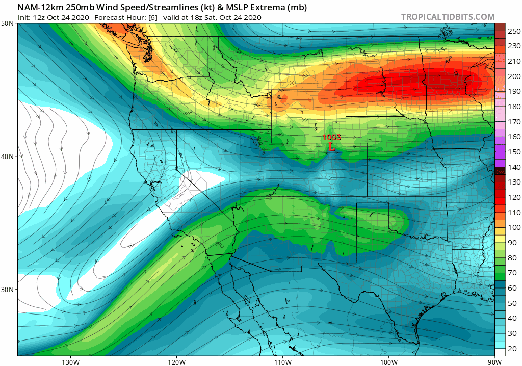
Unfortunately, before the snowy main event begins Saturday night, a day of mild and dry downslope lies ahead with strong westerly flow aloft pushing across the state of Colorado. Models indicate that a mountain wave is present Saturday morning with enhanced wind speeds just below mountain-top level east of the Continental Divide.
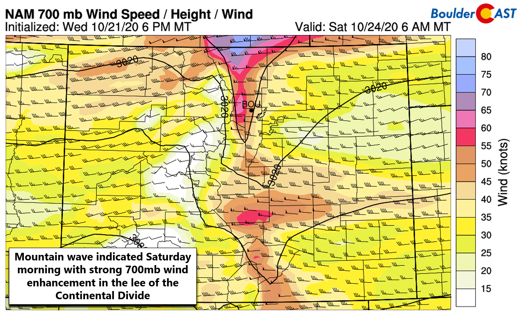
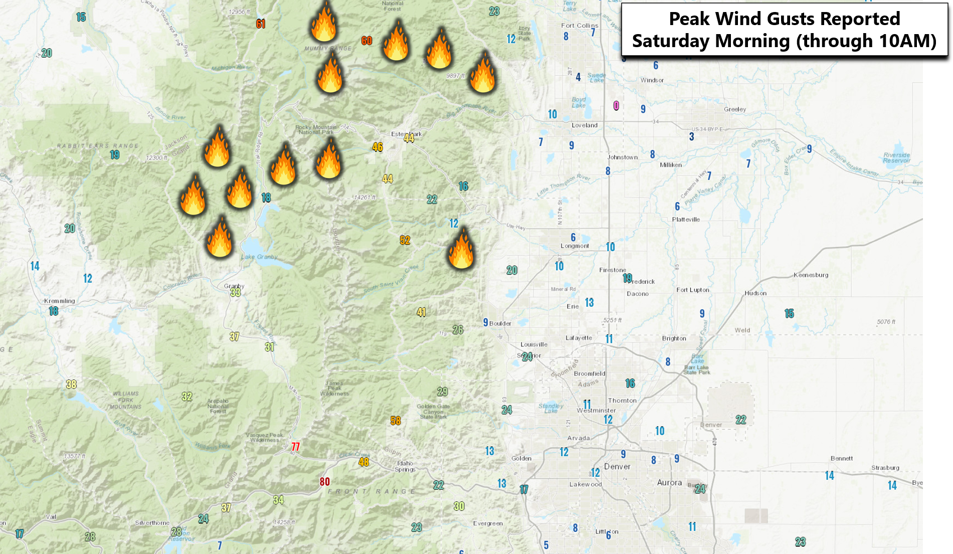
This will create dangerous fire conditions through the morning, especially in the Mountains and Foothills where gusts of 40 to 60 MPH will be possible above 7000 feet elevation. The mountain wave is forecast to dissipate through the day, but general mixing will keep those gusty winds active in the higher terrain, with breezy conditions possible across the lower elevations by afternoon. This does not bode well for area fires that will have to endure a period of favorable growth conditions today before the snow and cold arrive late tonight. Peak gusts this morning from around the area are shown below. We need to watch closely what happens around Grand Lake, Granby, and Estes Park as the East Troublesome Fire is burning just to their west. Red Flag Warnings are in effect Saturday for the entire area above 6500 feet elevation.
Temperatures across the Plains will be tough to predict for the day Saturday. Where the inversion breaks and gusty west winds enter the picture, highs will climb into the 60’s. It’s unclear if this will happen everywhere or not today across the Plains. It’s conceivable that some areas, especially north and west of Denver towards Boulder, don’t get out of the 40’s today. Whatever unfolds Saturday in your area, get outside and enjoy the weather if you can. We promise it will be much better than what is lurking around the corner! The leading edge of the cold air will arrive promptly around or slightly after sunset Saturday evening. A secondary push of Arctic air will funnel in a handful of hours later overnight with temperatures dropping rapidly into the 20’s and teens overnight.
The overhead jet will be slow to move in through the night but it will make persistent and gradual progress southward into the Boulder-Denver area towards sunrise Sunday. Snow may begin along the Wyoming border before midnight. It will then fill-in across the Metro area through the wee morning hours towards sunrise Sunday. Once it gets started, banded snow will be possible anywhere across our area through the day Sunday into Sunday night. Snowfall rates of 1 to 2″ per hour in these bands will create whiteout conditions and lead to rapid accumulation in localized areas. The most favorable location for banded snow will actually be across the Mountains, according to the high-resolution models. Our area will be on the fringe of the strongest lift, but it should still be plenty sufficient to produce widespread snowfall for a period of about 24 hours.
Snow will begin to wind down late Sunday night and taper off fully Monday morning or early afternoon.
Snow Amounts
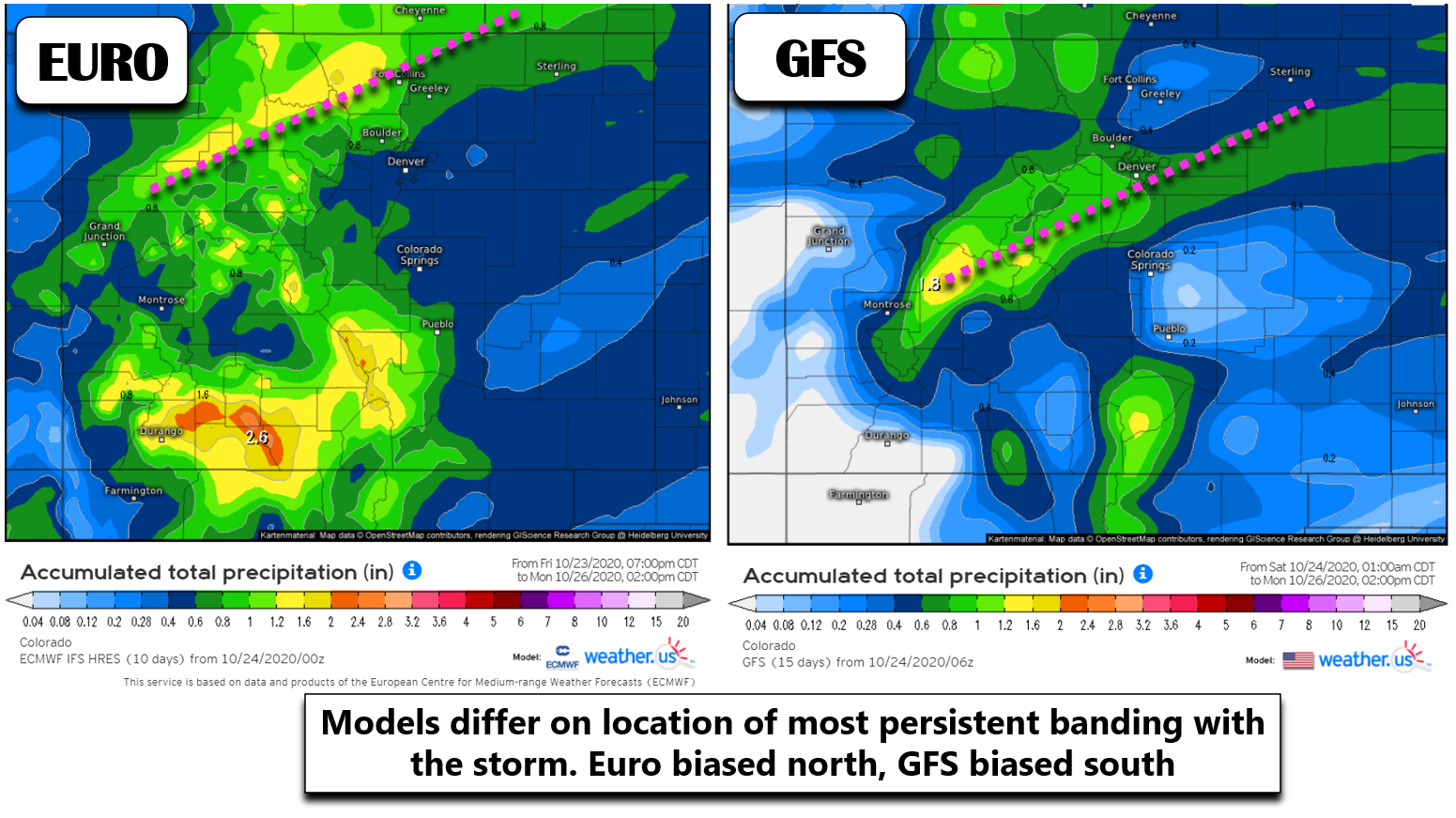
Models have consistently been indicating that a broad brush of 0.5 to 1.0″ of liquid will fall across the Front Range from this storm system. This is just what we need considering the active wildfires and on-going severe drought. However, the problem is that unlike a typical upslope event where we know which areas will get the most snow and those that won’t, the jet-forced nature of this storm leads to a bit of ambiguity in which spots will get hit hardest. As mentioned earlier, we believe the most persistent banding will be focused just west of our area across the Mountains. The global weather models remain torn on whether the better banding will occur north or south of our area. The Euro and Canadian (not shown) models favor Fort Collins into Cheyenne, while the GFS targets southern Denver and the Palmer Divide.
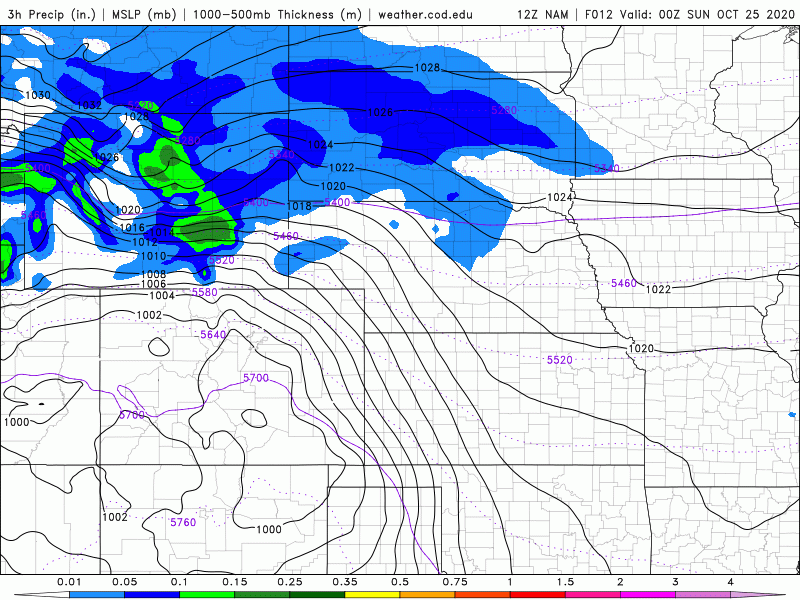
Higher-resolution regional models like the NAM seem to also favor the northern tier of the Front Range (shown below). This northern bias is also indicated by the HRRR model (not shown).
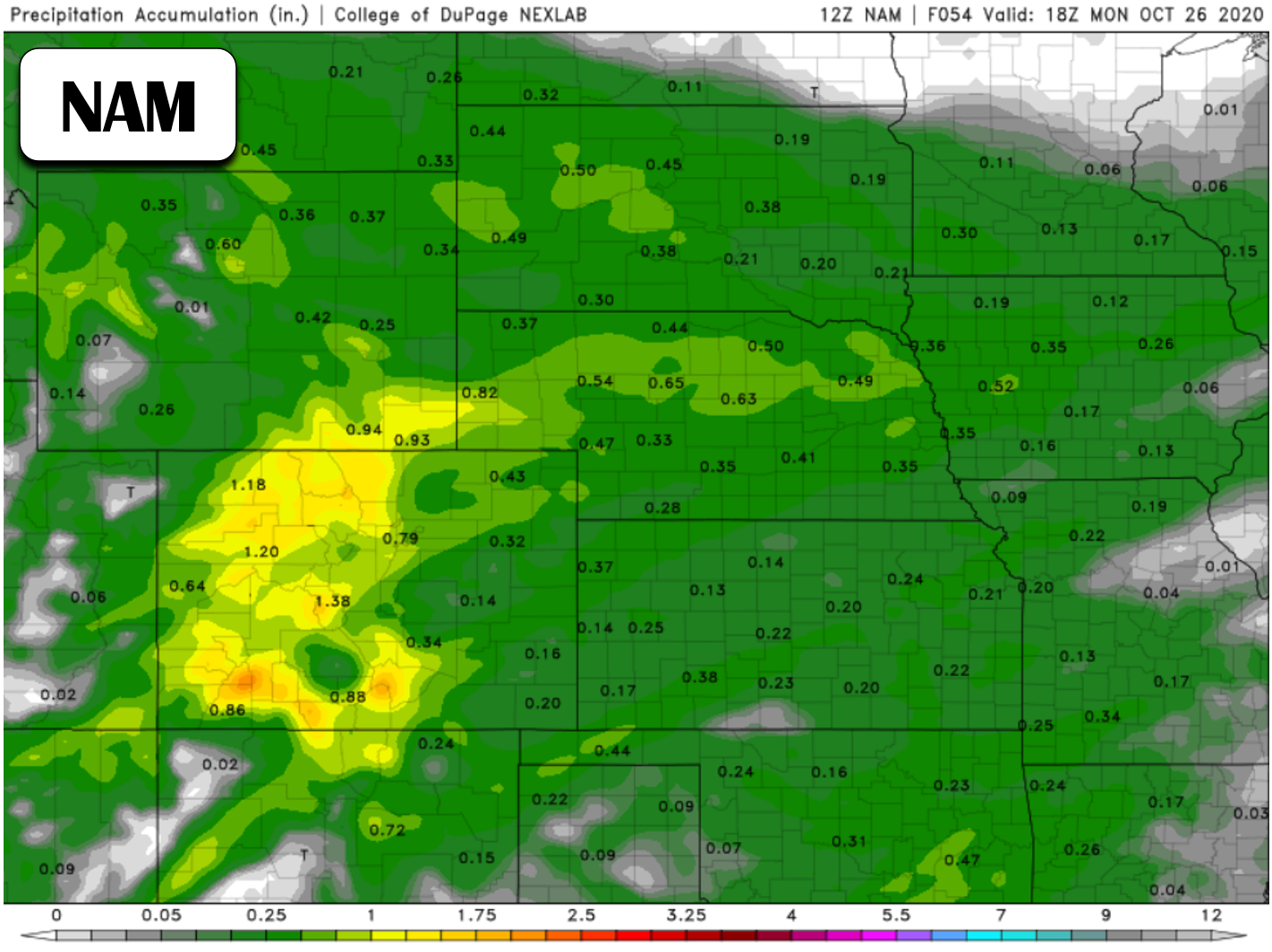
With most models leaning towards a more northern setup to the heavy bands, we believe those areas will see the most snow from this system. The immediate Metro area is looking at a solid 4-8″ by the time things are all said and done around midday Monday, with amounts inching upwards heading west and north across the Boulder area.
Our snowfall forecast map for the event is shown below. This covers snow falling throughout the entire duration of the storm into Monday afternoon. Keep in mind that due to the particularly banded nature of this event and meager upslope, we’re sure there will be highly variable snow totals over relatively small distances. Localized spots could end up on the high or low side of the fence, sometimes immediately adjacent to one another.
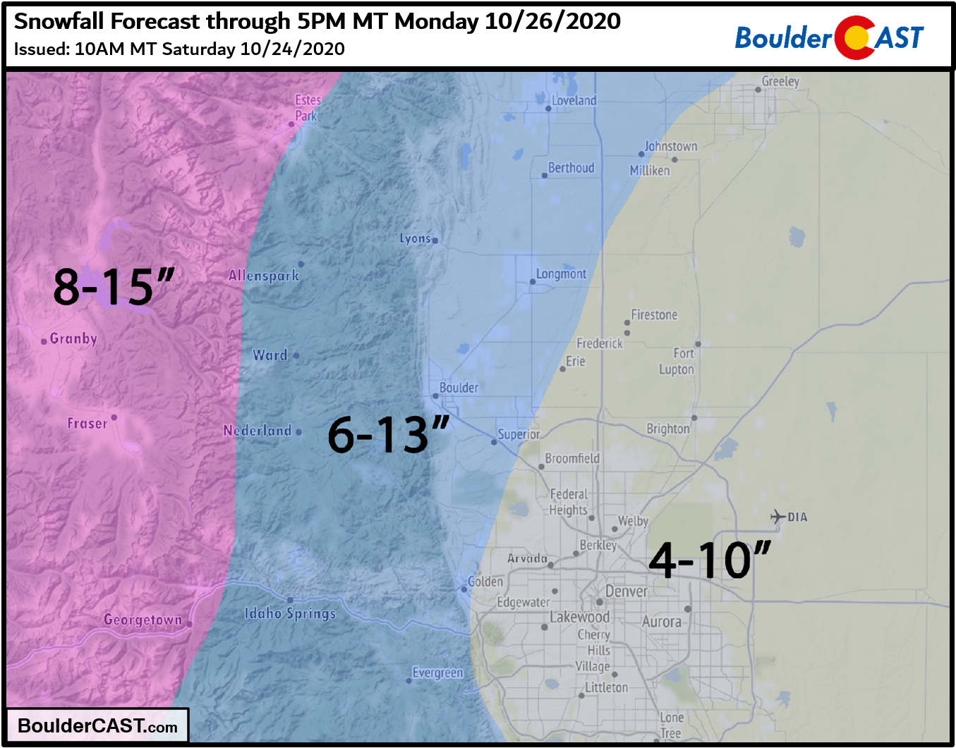
Travel impacts will be likely during the day Sunday and Sunday night as very cold temperatures combine with periods of moderate to heavy snowfall under the embedded bands. Slushy and eventually snow-packed roadways will be possible especially in the higher terrain where temperatures will be downright frigid.
Our final comments surround the bitter cold temperatures that will accompany the snow as the Arctic airmass plunges into Colorado. Temperatures on Sunday will be in teens around Boulder and Denver during the day. Shockingly, the existing record low in Boulder for October 25th is only 17°F. That will most likely be broken, possibly even during the middle of the afternoon. Sunday night into early Monday, temperatures could drop into the single digits across the area. Boulder’s existing record low on Monday is 19°F set back in 1932. We could easily obliterate that near century-old record by 10 or even 15 degrees given this airmass. Plan for extremely cold temperatures beginning late tonight into Tuesday morning.
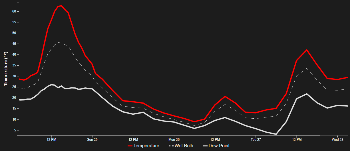
The climb back out of the snowy and cold hole will be a slow one with temperatures warming up but still not getting back to normal until the latter part of the upcoming work week.

For additional pre-storm discussion on this winter event, listen to our recent ~30-minute episode of the BoulderCAST Podcast recorded on Friday.
Whether or not you’re a fan of the cold and snow, let’s all be thankful for this moisture. We’ll be back on Monday with our regularly scheduled weather outlook, which we’ve been doing for nearly 300 straight weeks. Stay warm!
Subscribe to receive email notifications for BoulderCAST updates:
We respect your privacy. You can unsubscribe at any time.
Help support our team of Front Range weather bloggers by joining BoulderCAST Premium. We talk Boulder and Denver weather every single day. Sign up now to get access to our daily forecast discussions each morning, complete six-day skiing and hiking forecasts powered by machine learning, first-class access to all our Colorado-centric high-resolution weather graphics, bonus storm updates and much more! Or not, we just appreciate your readership!
.
Spread the word, share this BoulderCAST post:
.


You must be logged in to post a comment.