
Monsoon lovers may have to wait awhile for our daily dosage of summer-time thunderstorms. Mid and long-range weather models predict a delay in the onset of monsoon season across the American Southwest. We discuss why this won’t necessarily impact Colorado all that much, at least compared to other states such as Arizona.
T
he diagram below shows the typical set-up for what is known as the North American Monsoon, a seasonal shift in the winds that happens every year across northwestern Mexico and the southwestern United States. A “monsoon” low pressure in southern California often teams up with high pressure in the southern United States to funnel relatively large quantities of subtropical moisture northward into the Desert Southwest. This moisture is key to forming those daily thunderstorms that are a staple of Colorado’s summer months. Along with the increased chance of daily thunderstorms, the monsoon brings more dangerous alpine hiking conditions, frequent evening rainbows, warmer nights, more lightning to spark wildfires, and “stickier” air overall.
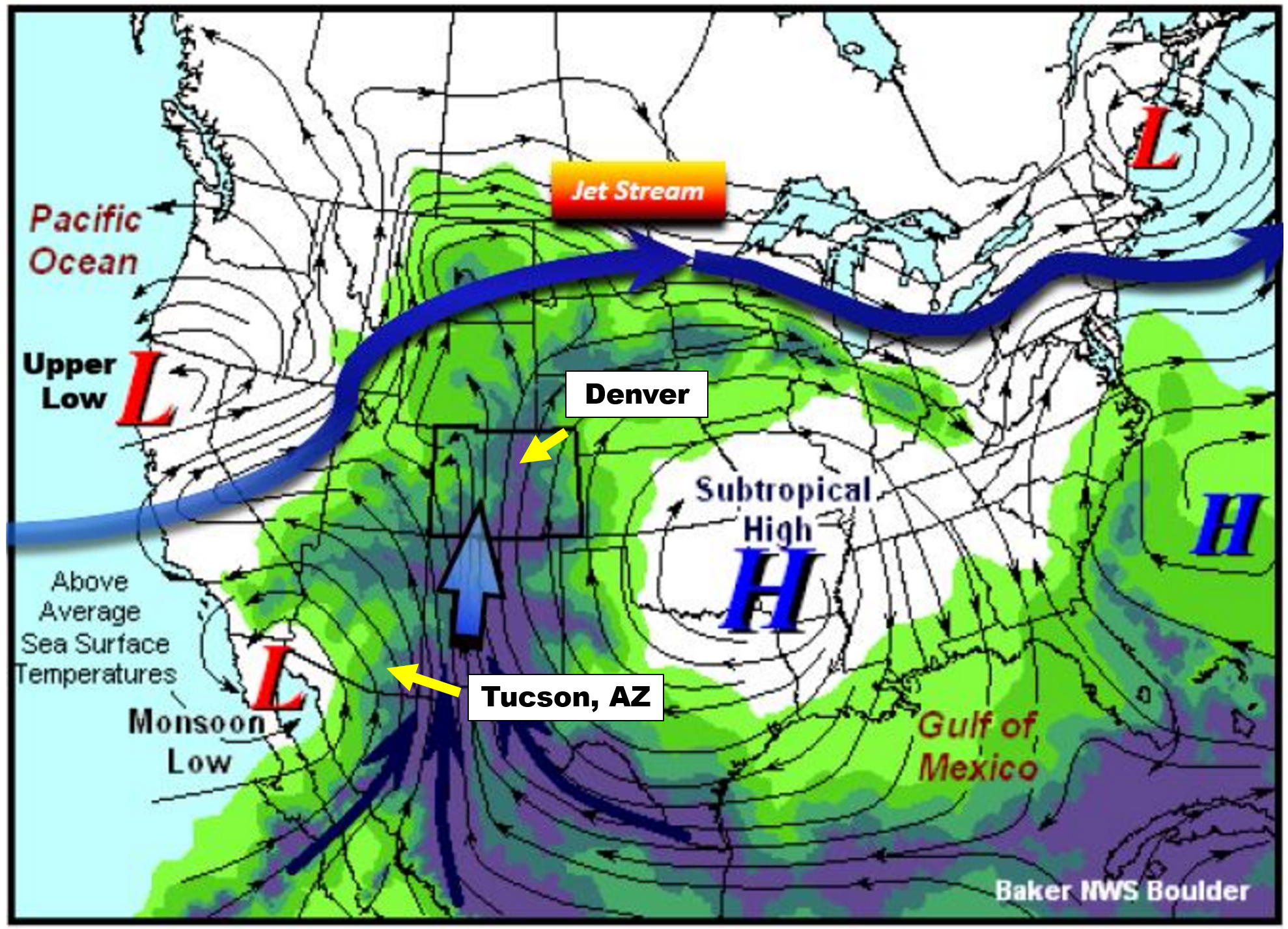
Monsoon set-up diagram | NWS Boulder
Officially, monsoon season across the American Southwest begins on June 15th and runs until September 30th. However, much like hurricane season, the official seasonal dates act only as rough guidance and do not necessarily reflect actual atmospheric conditions from year-to-year.
One way that we can track the true arrival of the North American Monsoon is to monitor surface dew points in southern Arizona. Cities like Tucson, which is just 60 miles from the Mexican border (see location above), are much closer to the source of the moisture than we are here in Denver. The moisture more-or-less has to pass through Tucson as it moves northward into the United States. Tucson is also a pivot-point for the moisture plume itself. Think of Tucson as the “faucet”, with a “hose” of moisture wandering northward. Sometimes the hose is over Nevada, other times it meanders over Utah, and Colorado as well.
While our monsoon is sporadic throughout July and August here in Colorado, the faucet is nearly continuous for Tucson. For this reason, Tucson actually sees more monsoon rainfall than Denver on average and has a more predictable and consistent monsoon climatology.

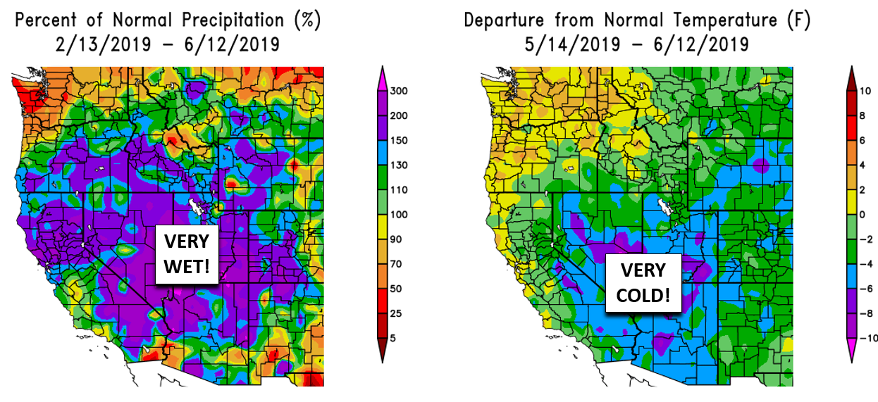
It is largely agreed upon that monsoon season’s true start is when the average daily dew point in Tucson is at least 54 degrees for three consecutive days. This parameter is closely monitored by meteorologists and residents of that area. We can’t blame them…July’s average rainfall exceeds the combined total for March, April, May and June in Tucson (above plot on the left). The monsoon is a much bigger reprieve for them than it is for us, especially considering the edge it can take off of those 100+ degree afternoons!

The graph below shows the daily average dew point values at Tucson Airport. The blue line is the actual data from June 2019 so far. The red line is climatology and the green line is the coveted 54-degree threshold for the monsoon.
![]()
Will the monsoon be late this summer?
As you can see from the graph above, yesterday’s average dew point was only in the lower 20’s. We are quite a ways from the beginning of monsoon season. This is normal. However, odds are elevated that this year’s monsoon may arrive later than normal. Here are a few reasons why:
1.. A weak El Niño continues in the tropical eastern Pacific Ocean. Shown below is an animation of the last 12 weeks of sea-surface temperature anomalies along the equatorial Pacific. The warm anomaly is clear, but this El Niño has been far from definitive and normal, with the strongest warming currently located in the central Pacific region, more akin to an El Niño Modoki. The climate model consensus keeps this pattern in-place through most of summer and climatologists warn that the presence of El Nino might delay the northward migration of the monsoonal high pressure, and thus, the arrival of the monsoon to Colorado.

2.. A key factor influencing the seasonal shift in winds that define the monsoon is warmth that slowly builds through May and June across the southwestern United States. Most of spring and especially the last month or so has been very cool and wet across this area. Though this week has turned hot and dry in Arizona, we consider the lack of much heat so far a set-back to the monsoon. Furthermore, all of the rain and remaining above normal snowpack has and will keep soil moisture elevated in these same areas. High soil moisture limits warming, especially in dry climates.
So what exactly does this all mean for the Front Range?
Frankly, the latest summer outlook issued by the Climate Prediction Center doesn’t appear too bad for Colorado with our region having the best odds of being wetter than normal this summer (June-July-August period).

This is because despite the possibility that monsoon season may be delayed, the mid-latitude storm track continues to hammer Colorado well into the month of June with general troughing across much of the northern United States. The bad news is that this type of pattern this time of year can prolong severe weather season in eastern Colorado well into July. Sometime similar actually happened last year. On the contrary, southern Arizona which relies much more heavily on a true monsoon pattern for their summer-time rainfall, has been given a drier than normal outlook for the next three months.

The take-away here is that while monsoon season could be slightly delayed in Colorado, we’re only talking a couple of weeks at most. And in its absence, the mid-latitude storm track should keep us from drying out too much. Our weather for the upcoming weekend is a prime example! Furthermore, the ongoing El Niño in the Eastern Pacific will favor an active hurricane season this year. As you know, the remnants of Pacific hurricanes can and often do impact Colorado, providing at least the potential for late summer and early fall to remain relatively wet in Colorado. We not shy about saying it, nothing at all indicates we are in any danger of slipping back into a drought anytime soon.
By the way, recently the U.S. Drought Monitor released a revision that removed all drought-related classifications from the state of Colorado:

For the first time 18 years, Colorado has no areas experiencing drought or even semi-dry conditions. What a glorious late winter and spring it has been!

Help support BoulderCAST by sharing this post:
.


You must be logged in to post a comment.