The Arctic chill is REAL this morning as temperatures hover around zero degrees with wind chills much colder than that! We provide an update on the blast of winter currently engulfing the Front Range, including a review of the snowfall totals so far, the expected record cold temperatures to be challenged in the coming days, and a look at how much snow is still to come.
At a Glance:
- The Arctic airmass is fully entrenched across the area and will remain in place through at least Friday night
- High temperatures in the single digits Tuesday and not much warmer on Wednesday either
- Several new record cold temperatures are likely in Boulder and Denver over the coming days
- 3″ of snow has fallen so far in Boulder, with around 1″ or less elsewhere
- Another 1-4″ of snow expected by Wednesday morning with more snow to follow Wednesday afternoon into the night
- We may finally get above freezing on Saturday — maybe!
We discuss Boulder and Denver weather every single day on BoulderCAST Premium. Sign up today to get access to our daily forecast discussions every morning, complete six-day skiing and hiking forecasts powered by machine learning, access to all our Front Range specific weather models, additional storm updates and much more!

WOW!
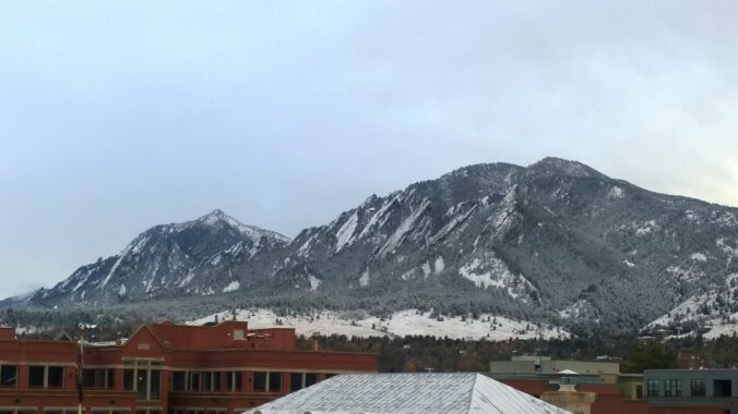
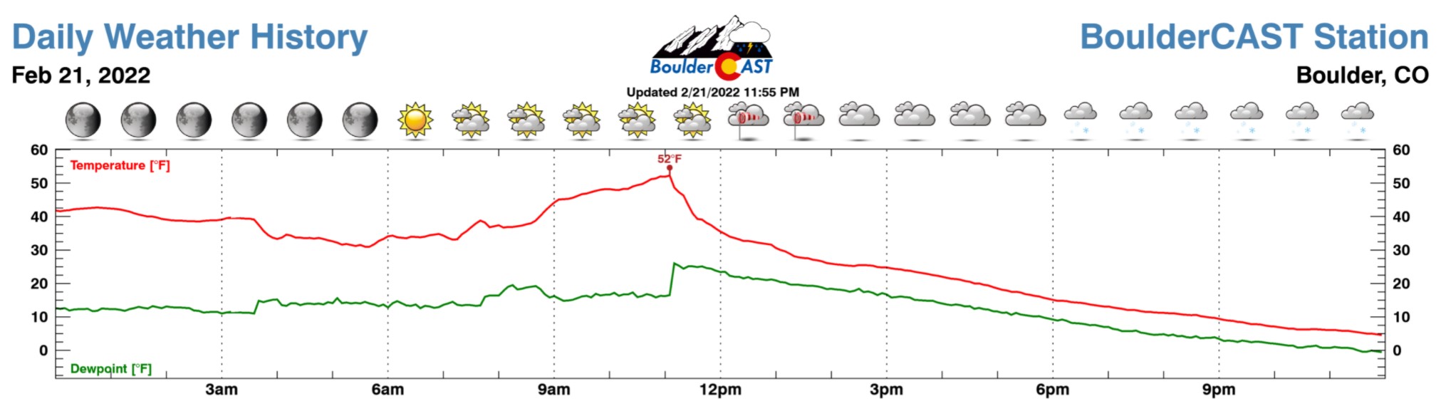
What a change has transpired over the last few days. From the 60’s on Sunday, to the 50’s early Monday, to below zero temperatures this morning! It’s been quite a wild ride so far as the well-advertised Arctic airmass has engulfed much of the state of Colorado. The initial cold front passed through our station in Boulder around 11AM on Monday when the temperature was a comfortable 52°F. The familiar “farmy” smell accompanying the frontal passage let everyone know that Mother Nature was not messing around this time and winter was on the way!
Mmm, the good, wintery smells have arrived🐄🚜🌾 https://t.co/ehRTC56uKE
— BoulderCAST Weather (@BoulderCAST) February 21, 2022
By midnight Monday night, the temperature had dropped nearly 50 degrees all the way down to 4°F with light snow falling the entire evening.
Currently temperatures are hovering right around 0 degrees in the Denver Metro area, with many spots slightly below zero.
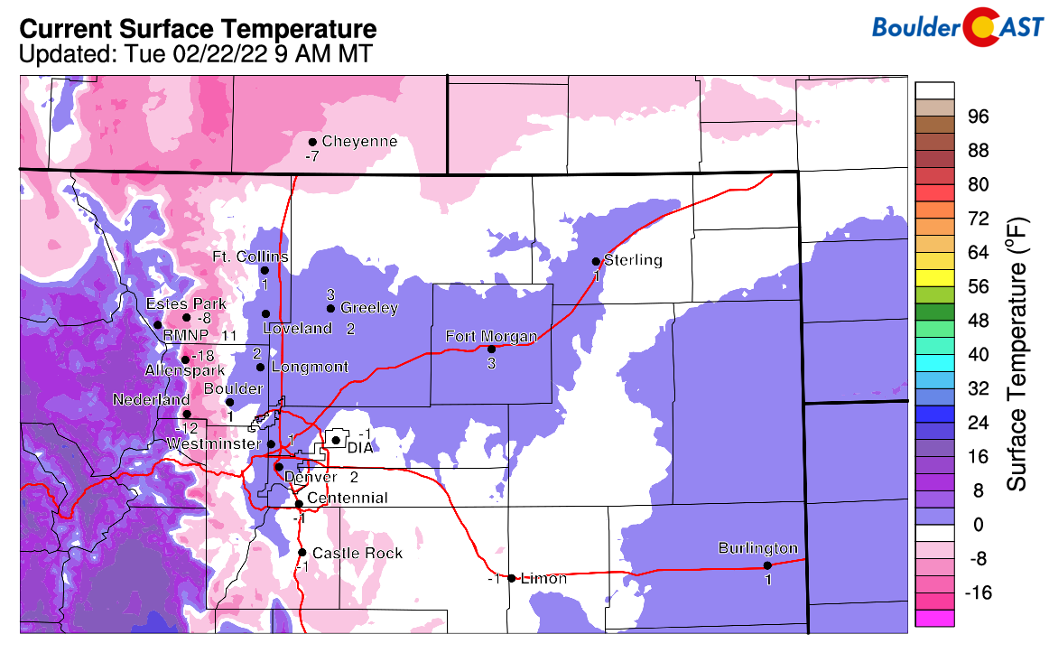
Factoring in the breezy northeast winds, it feels more like 5 to 15 degrees below zero!
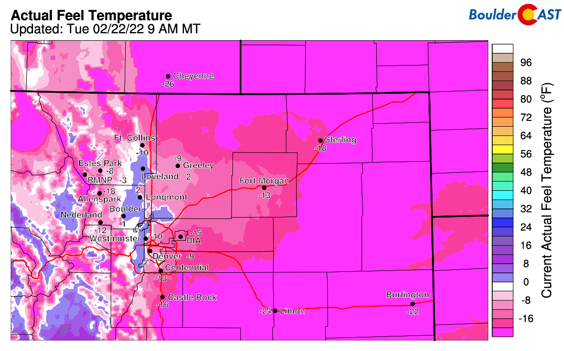
Don’t even get us started on the truly polar temperatures upstream to our north!
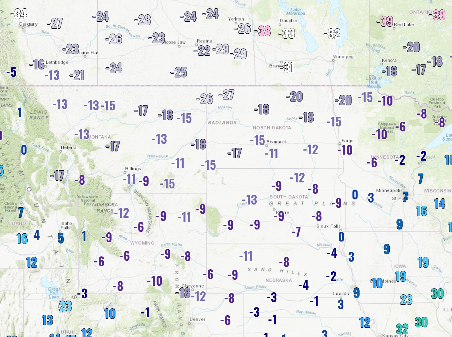
Tuesday morning low temperatures across the northern Rockies and Great Plains — Brr!
The bitter cold temperatures are truly the headline this week with several records likely to be challenged or broken in the coming days. The prolonged period of intermittent light snow accompanying that cold is just the icing on the (ice cream?) cake!
Here’s a look at some of the records up for grabs this week in Boulder and Denver:
- Boulder
- Tuesday (2/22): Record Low -1°F (1911), Forecast Low -2°F
- Tuesday (2/22): Record Low High 15°F (1899), Actual High 18°F (occurred Monday at 5PM)
- Wednesday (2/23): Record Low -5°F (1899), Forecast Low -3°F
- Wednesday (2/23): Record Low High 16°F (1899), Forecast High 11°F
- Thursday (2/24): Record Low -4°F (2003), Forecast Low 2°F
- Denver
- Tuesday (2/22): Record Low High 13°F (1922), Forecast High 9°F
- Wednesday (2/23): Record Low -4°F (1899), Forecast Low -5°F
- Wednesday (2/23): Record Low High 10°F (1879), Forecast High 13°F
- Thursday (2/24): Record Low -8°F (1874), Forecast Low -2°F
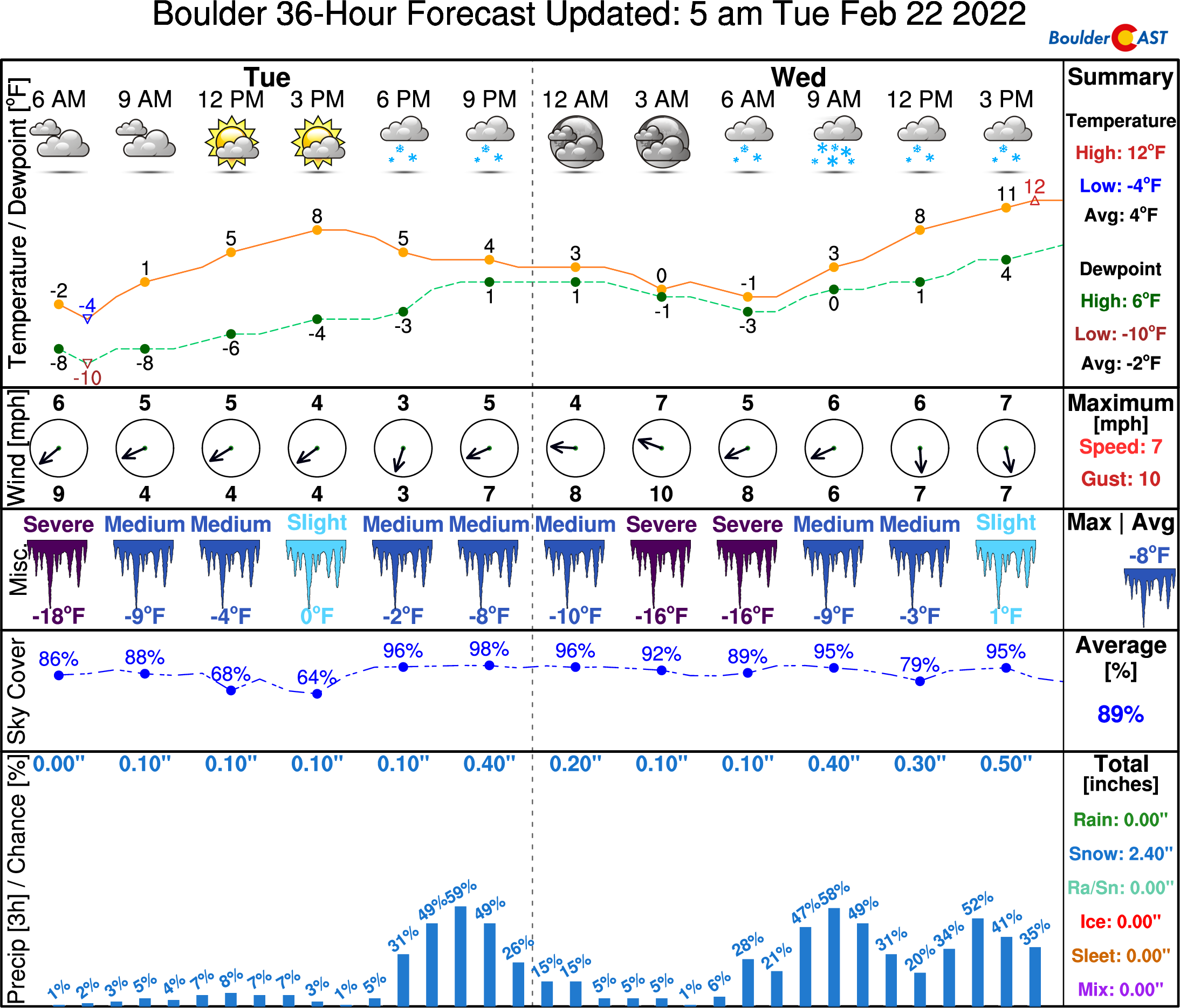
Remarkably, temperatures won’t get out of the single digits on Tuesday in Boulder and probably not in Denver either. NowCAST has a high of 8°F in Boulder Tuesday afternoon — this is probably optimistic considering the northeasterly winds, overcast skies, and intermittent snow. The Arctic airmass really doesn’t want to warm up so we’ll likely stay even colder! Wind chills will remain below zero all the way into Thursday morning, so be sure to bundle up if headed out and about into the winter wonderland!
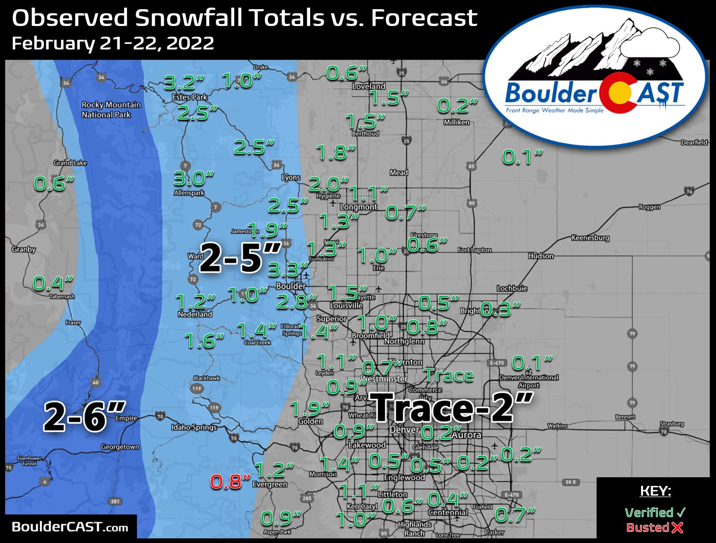
So far as of Tuesday morning, about 3″ of snow has fallen in Boulder, the most out of the entire Denver Metro area. In the near-absence of any upper-level forcing, weak and frigid northeasterly upslope butting up against the Flatirons is the absolute best mechanism for wringing moisture out of this very dry Arctic airmass. Elsewhere across the Denver Metro, most areas picked up a dusting to 1.5″ so far. Shown below is our snowfall forecast map for the first wave of snow ending Tuesday morning. Observed snow totals are overlaid. Green numbers indicate our forecast verified to within 1″. Red did not. We’re happy with the way things played out so far, but some of the Foothills have come in on the lower side.
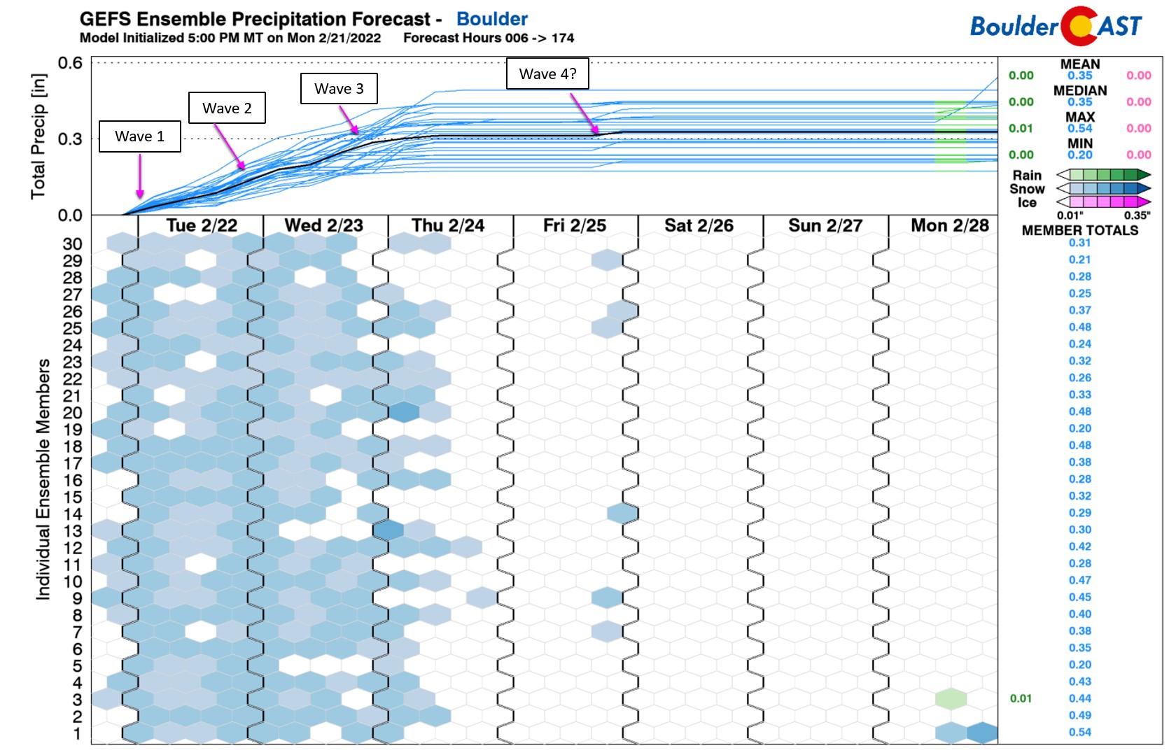
The deep trough across the West is visible in the infrared satellite animation below from this morning. The primary storm system is still all the way back west near the border of Oregon and California. Out ahead of this system, there will be several pulses of energy in the southwesterly flow which will team up with the Arctic upslope to aid in snowfall production across our area. The forcings passing through will be on the weaker side, but they will certainly help things along today and Wednesday for continued light snow.
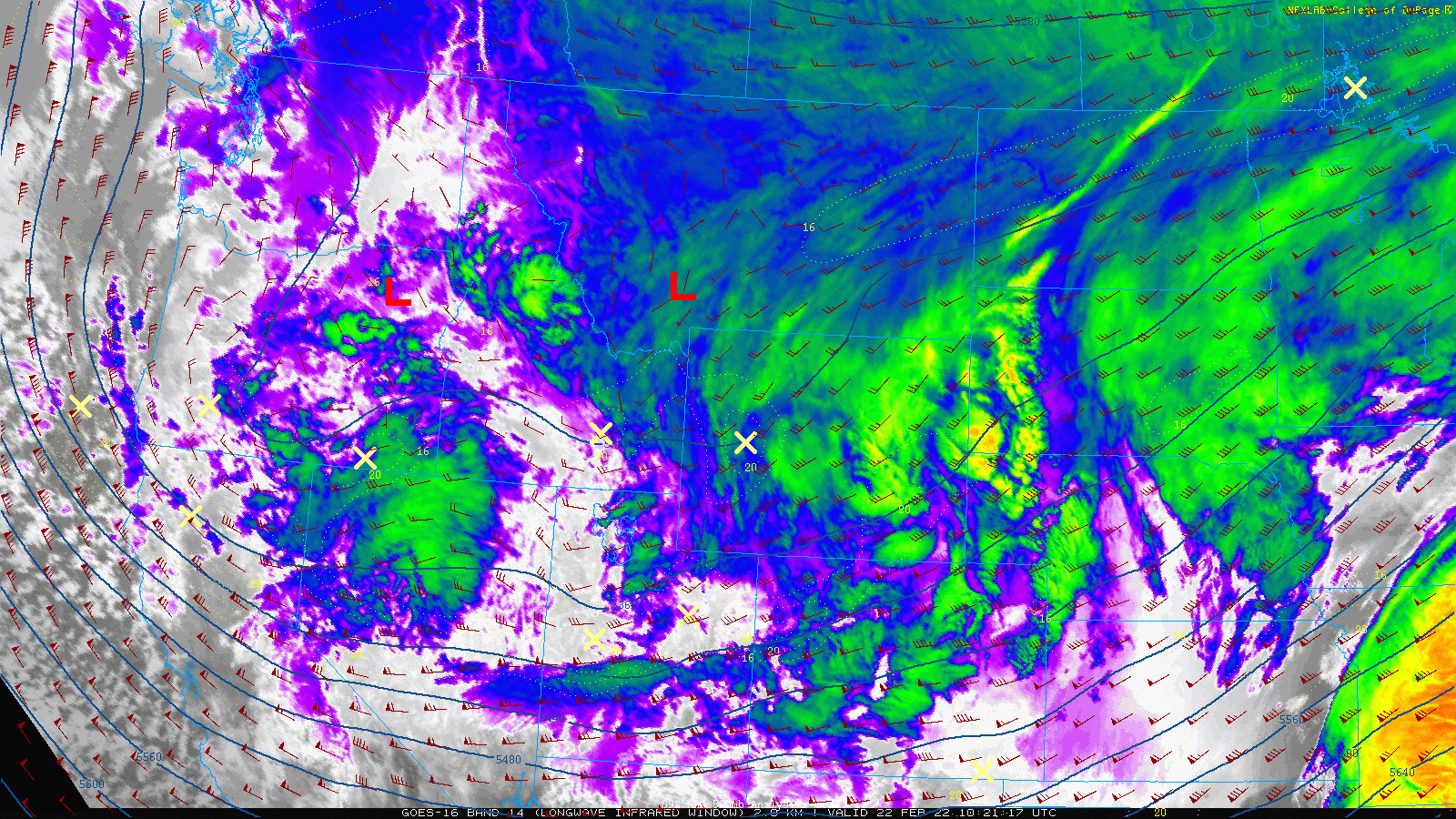
GOES-East infrared satellite animation from Tuesday morning
After a brief lull in the action during the day Tuesday, the next wave of upper-level forcing and moisture will arrive to the Front Range Tuesday afternoon. In areas highly-favored by upslope flow like Boulder, snow may never actually fully cease. In fact, that is our expectation today. Areas away from the base of the Foothills can look forward to some dry time today before the snow ramps back up by mid to late Tuesday afternoon. This incoming second wave of snow will be focused from about mid afternoon until midnight or so. As was the case today, lighter upslope snow will linger in and near the lower Foothills into the day Wednesday as well (maybe again not fully stopping in Boulder).
Our snowfall forecast map below covers this anticipated second wave of snow — basically everything falling from Tuesday morning through Wednesday morning.
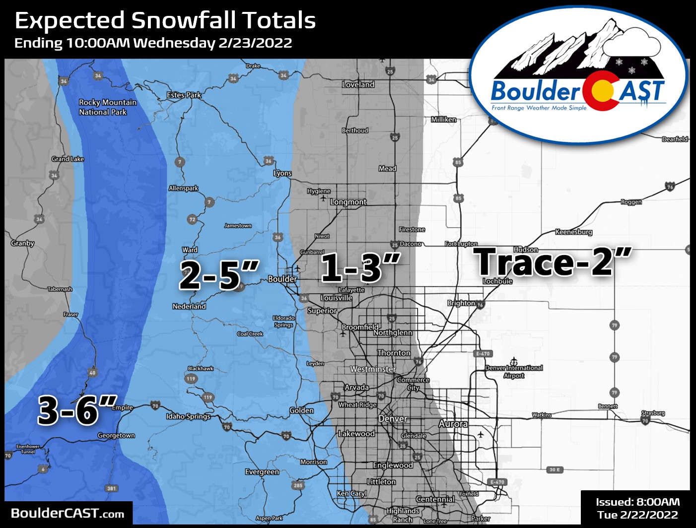
There will also be a third wave of snow Wednesday afternoon into early Thursday morning as another pulse of energy passes through. This will actually be the remnants of the main storm system so it may pack a slightly bigger punch in terms of snow amounts — we think. It’s still uncertain, but for now plan on at least as much snow falling late Wednesday as will fall today and tonight. There may also be a weaker trailing trough to watch for on Friday, but that looks to mainly impact the Mountains with just a dusting or less for the Plains, if that.
Thus, the TOTAL snowfall amounts throughout the ENTIRE week should end up something like as follows:
- Boulder: 5-9″
- Denver Metro: 2-6″
- Denver Int’l Airport: 1-3″
- Foothills: 4-9″
That’s all we’ve got for you today. Hang in there — it still looks like we should finally get back above freezing Saturday afternoon, but no guarantees on that just yet. Stay warm!
With five straight days of sub-freezing temperatures in the pipeline, there's no better time to dust off the soup recipes. Tonight we've got loaded baked potato chowder! What else is good? #cowx #arcticmenu #soup #snow pic.twitter.com/6cjIOnlajG
— BoulderCAST Weather (@BoulderCAST) February 22, 2022
Get BoulderCAST updates delivered to your inbox:
Help support our team of Front Range weather bloggers by joining BoulderCAST Premium. We talk Boulder and Denver weather every single day. Sign up now to get access to our daily forecast discussions each morning, complete six-day skiing and hiking forecasts powered by machine learning, first-class access to all our Colorado-centric high-resolution weather graphics, bonus storm updates and much more! Or not, we just appreciate your readership!
Enjoy our content? Give it a share!


You must be logged in to post a comment.