
This week’s weather is front-loaded with light snow and colder temperatures Monday night into Tuesday. We discuss potential snow accumulations for the Front Range, then detail quiet and seasonal conditions returning for the remainder of the week.
Snow Monday night into Tuesday
We begin the first full week of November with a weak trough approaching from the northwest. West-southwest flow across Colorado will lead to temperatures in the low 50’s this afternoon. This is right around average for this time of year.

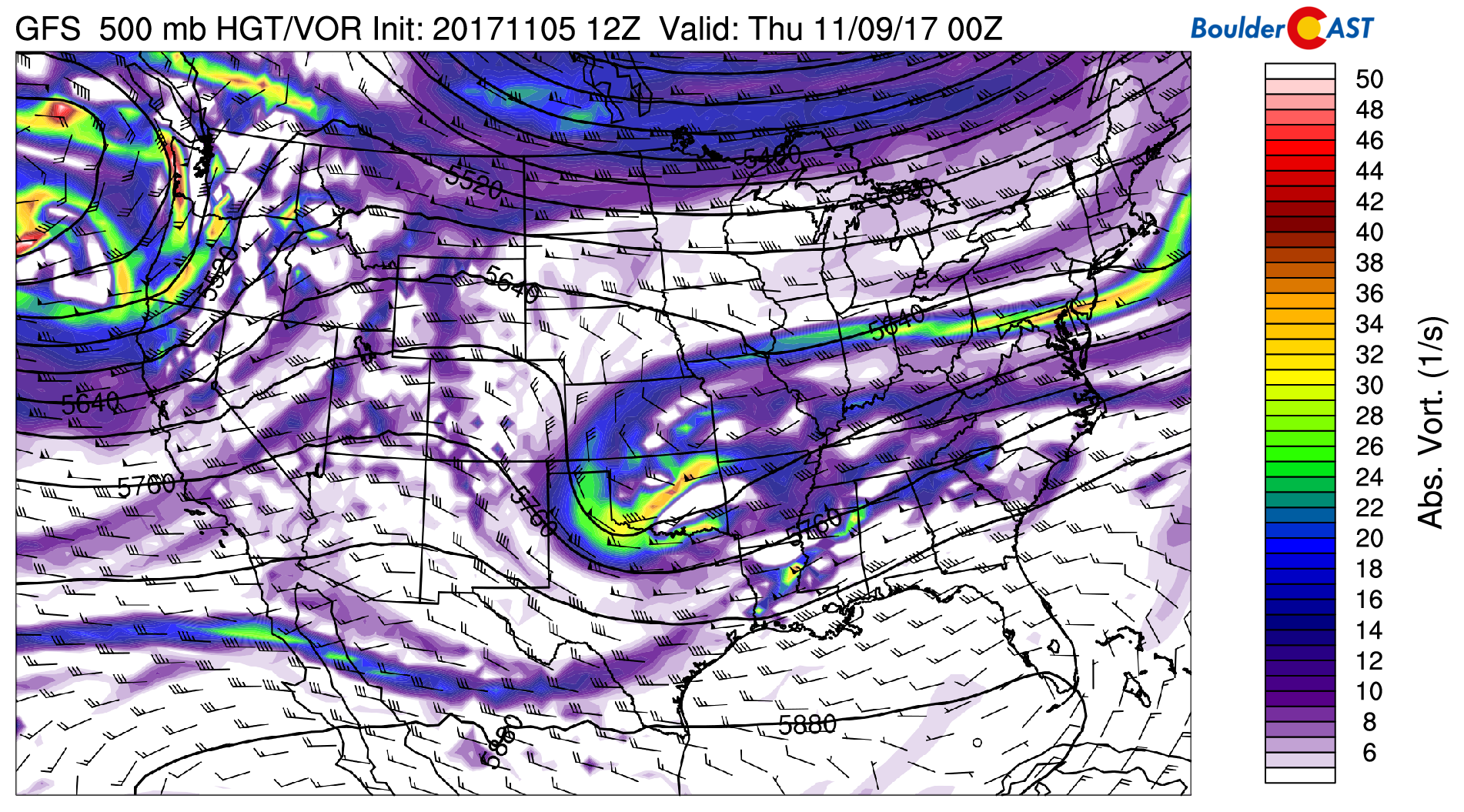
GFS 500 mb vorticity map for Monday evening.
Shallow upslope and low-level moisture is creating dense fog across the Metro area this Monday morning, with light drizzle/mist falling in areas along the base of the Foothills. Temperatures are generally 33 to 35 degrees across the Plains, so it isn’t freezing fog or drizzle. Just a nice moist chill to the air this morning!
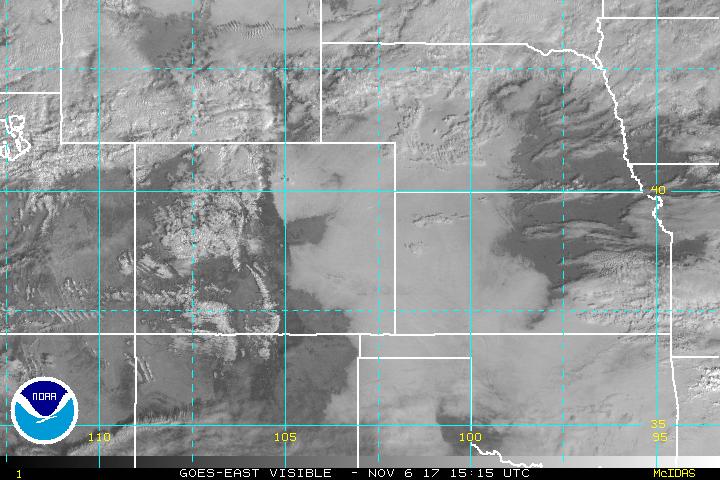
Current visible satellite as of 7AM Monday
Now…about tonight’s snow…
The forcing is multi-faceted, with no single component all that impressive….
1) A cold front associated with the trough will swing into northeast Colorado after sunset tonight. This will produce shallow upslope and drop temperatures quickly into the low 30’s and eventually 20’s by morning. The upslope will not even reach up to the 700 mb level. However, it will be enough for light snow to commence around midnight and continue into Tuesday.
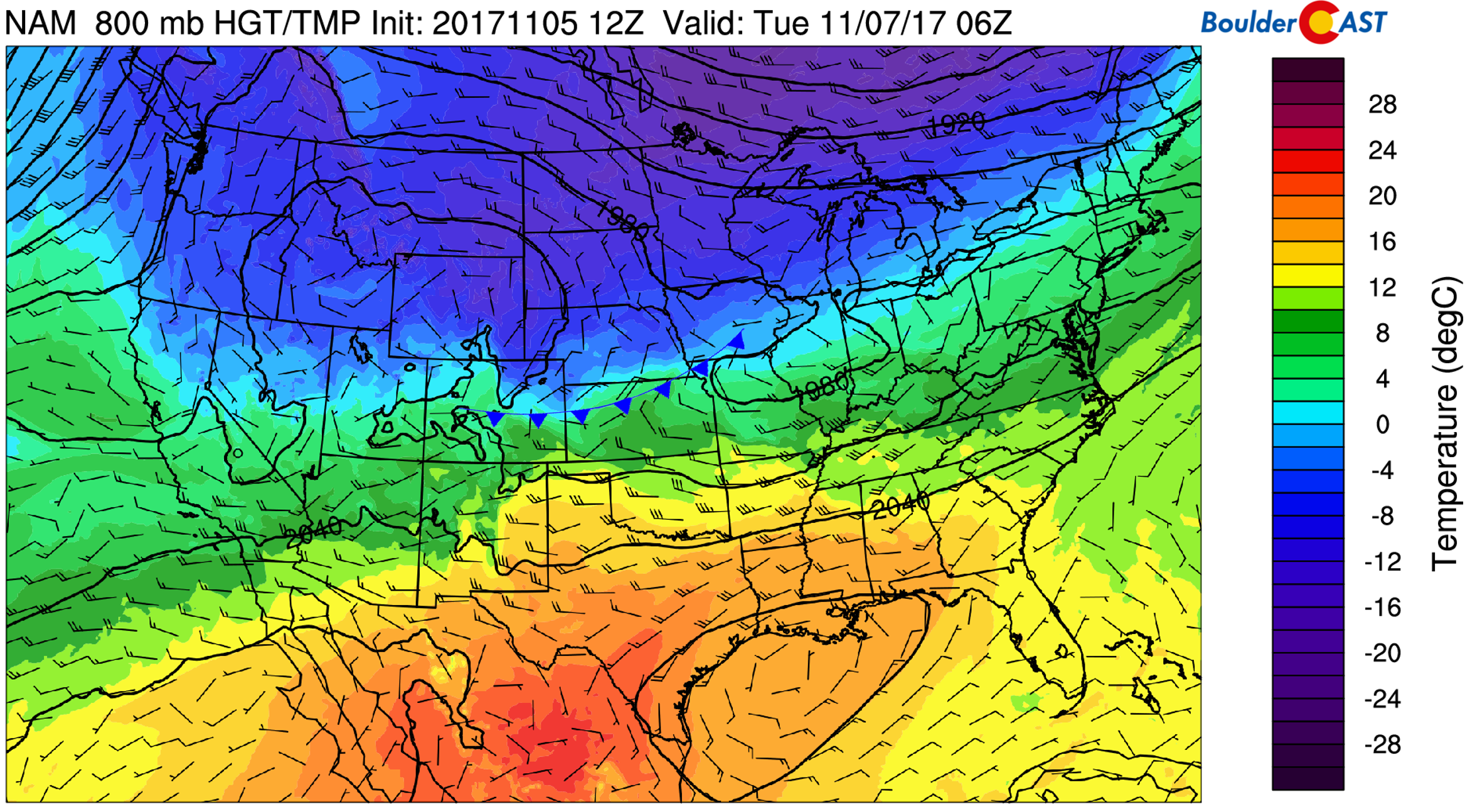
NAM 800 mb temperature and wind forecast for Monday night showing the position of the cold front
2) An atypically strong southern jet is stretched across the state. Northern Colorado will be in the left exit region late tonight and Tuesday morning.

GFS 250 mb winds for Monday night showing the position of the jet streak
3 ) This subtropical jet is carrying abundant moisture in the mid-levels of the atmosphere.

GFS atmospheric moisture anomaly for Monday night
The net effect of this jet and the cold front is that “warm” moist mid-level air is overrunning the low-level cold airmass across eastern Colorado. When also combined with topography, this is a great mechanism for snowfall!
4 ) The duration for light snowfall is 14 to 18 hours…. midnight Monday night through Tuesday evening.
This set-up will continue to dump powder across the Mountains today, with lighter snowfall spilling over to the Foothills and Denver Metro area tonight. While snowfall rates will generally be light, the duration of the event into Tuesday afternoon means 2 to 4″ snow totals will be common across the Plains, with perhaps twice this amount in the Foothills where the seeder-feeder will be in play. Furthermore, while difficult to pin-point the exact location, models are indicating the development of a few heavier snow bands associated with the jet. Latest high-resolution models have these bands mostly around Fort Collins and not so much in Boulder. However, we have seen models trend further south in the last few runs, so we need to be weary of a few 1+” per hour snowfall bands across the Boulder/Denver area.
Given everything we are seeing, our thoughts are summarized in our snowfall forecast map:
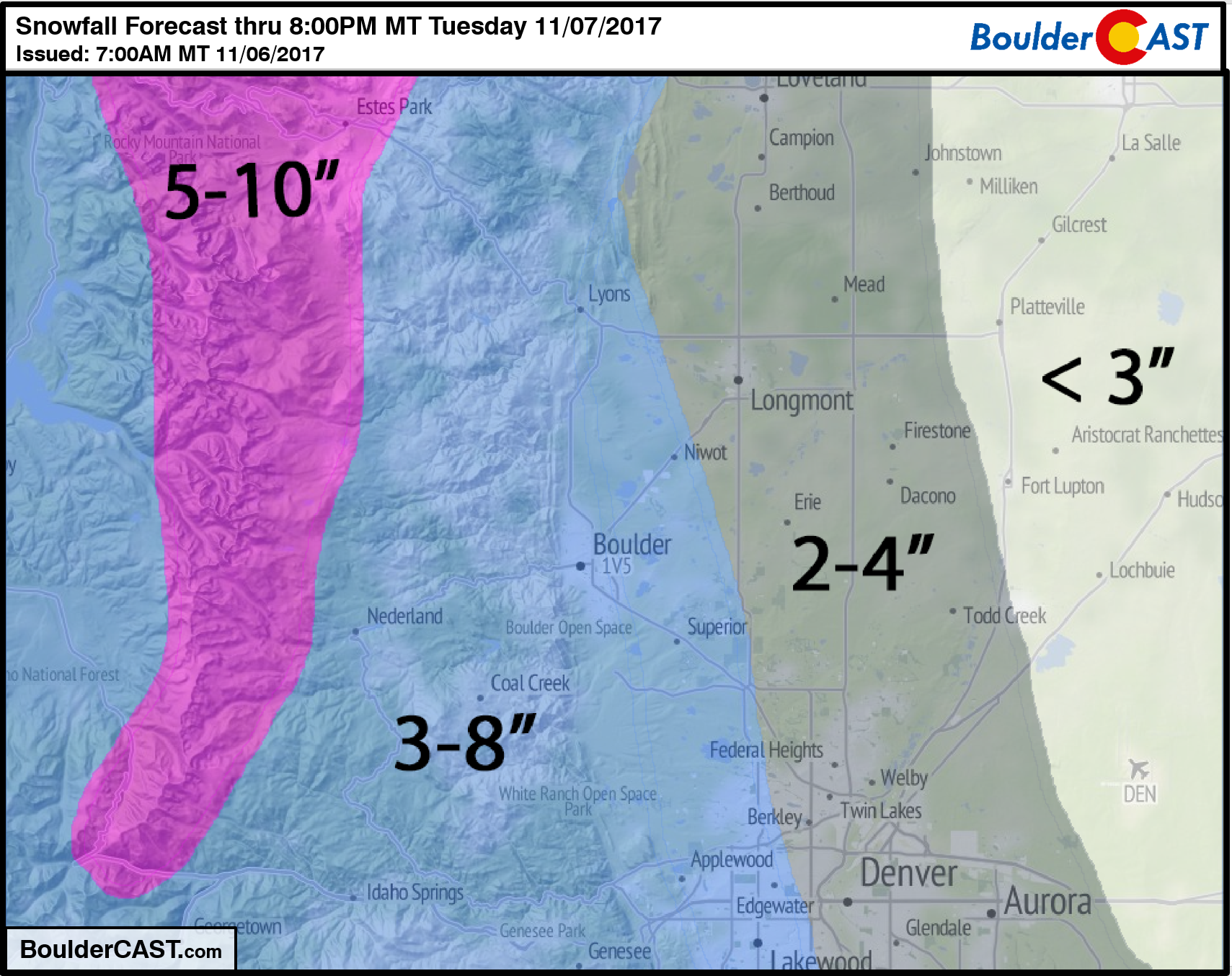
Light snow will linger in and near the Foothills into Tuesday evening, with overcast skies prevailing through the day. Highs will struggle to reach 30 degrees. Brrrrr!
Three-day snow totals in the high Mountains north of Interstate 70 will be 1 to 2 feet (Saturday night through Tuesday morning).
Wednesday warm-up
Short-wave ridging will develop across the southern Rockies by mid-week. The 500 mb map below for Wednesday shows the departing storm system into Oklahoma and Texas. A ridge axis is already developing across western Colorado. Models generally agree that this ridge will persist at least through Friday, with quiet and warmer weather returning to the Front Range.
We should see our temperatures jump to near 50 on Wednesday, with near 60 Thursday and 60’s Friday. Another trough is eyeing our region this weekend. However, models are not in good agreement on direct impacts to northern Colorado at this time. For now, expect continued quiet weather for the weekend, with an outside chance of light Mountain snowfall.
Forecast Specifics:
Monday: Morning fog and mist, then partly cloudy and cool with highs in the 40’s across the Plains and upper 30’s in the Foothills. Snow showers will be possible through the day along and west of Peak to Peak Highway. A cold front will move into the region after sunset, with snow showers developing before midnight.
Tuesday: Overcast with light snow showers tapering off in the afternoon or evening. Expect total snow accumulations of 2-4″ for the Denver Metro area, with 3-8″ in the Foothills. High temperatures in the low 30’s across the Plains with mid 20’s in the Foothills.
Wednesday: Partly sunny with snow melting across the region. Highs will climb into the upper 40’s across the Plains, with mid 30’s in the Foothills.
Thursday: A mix of clouds and sun and warmer. Highs in the mid to upper 50’s for the Plains and mid 40’s in the Foothills.
Friday: Partly sunny and mild with temperatures in the low 60’s on the Plains and mid 50’s in the Foothills.
Weekend: The upcoming weekend looks relatively quiet across the Front Range. We’re watching a trough that should remain weak and north of Colorado. With this, expect dry weather and seasonal or slightly warmer weather this weekend.
High Country: Heavy mountain snowfall continues Monday into Tuesday for northern Colorado. The hardest hit locations will be the Front Range north of Boulder, and the Gore Range near Steamboat. Storm totals of 12-24″ are likely for high alpine areas in these ranges. Dry weather then takes over for the rest of the week, though strong westerly flow will be in place Thursday and Friday. Find the latest forecast for all your favorite Colorado ski resorts on our PowderCAST page.
DISCLAIMER: This weekly outlook forecast is was created Monday morning and covers the entire upcoming work-week. Accuracy will decrease as the week progresses as this post is NOT updated. To receive daily updated forecasts, subscribe to BoulderCAST Premium.

Share our forecast:
Mon
Tue
Wed
Thu
Fri


Temperature
47
31
48
55
61


Precip Chc (Plains)
0%
100%
0%
0%
0%


You must be logged in to post a comment.