It’s business as usual to start the week with continued mild conditions through Wednesday. However, we are keeping close tabs on a developing winter storm later this week. It’s a complex system to say the least and our confidence in the forecast is low right now, but we could be talking up to a foot of snow in some portions of the Metro area by Friday morning. Read on for our complete outlook for the next five days.
This week’s highlights include:
- Generally quiet conditions Monday through Wednesday with above normal temperatures
- A shallow cold front spawns low clouds and patchy fog/drizzle Monday night into Tuesday morning
- A messy forecast is shaping up for Thursday with rain changing to wet snow
- Though highly uncertain, the Front Range could see 6+” of wet snowfall
- A chilly end to the week with highs in the 30’s on Friday
DISCLAIMER: This weekly outlook forecast is created Monday morning and covers the entire upcoming week. Accuracy will decrease as the week progresses as this post is NOT updated. To receive daily updated forecasts from our team, subscribe to BoulderCAST Premium.
Continued mild weather to start the week
For what seems like the third or fourth week in a row, our forecast discussion begins with yet another cut-off low pressure system spinning off the coast of California. This morning’s infrared satellite animation from GOES-East shows the system currently centered northwest of San Francisco. A plume of moisture is streaming into the area from the south. This slow-moving storm and associated deep moisture has prompted Winter Storm and Avalanche Warnings across the Sierras, with many mountain locations expected to receive 2 to 6 feet of snow in the coming days.

GOES-East infrared satellite animation near California Monday morning showing the approaching storm system
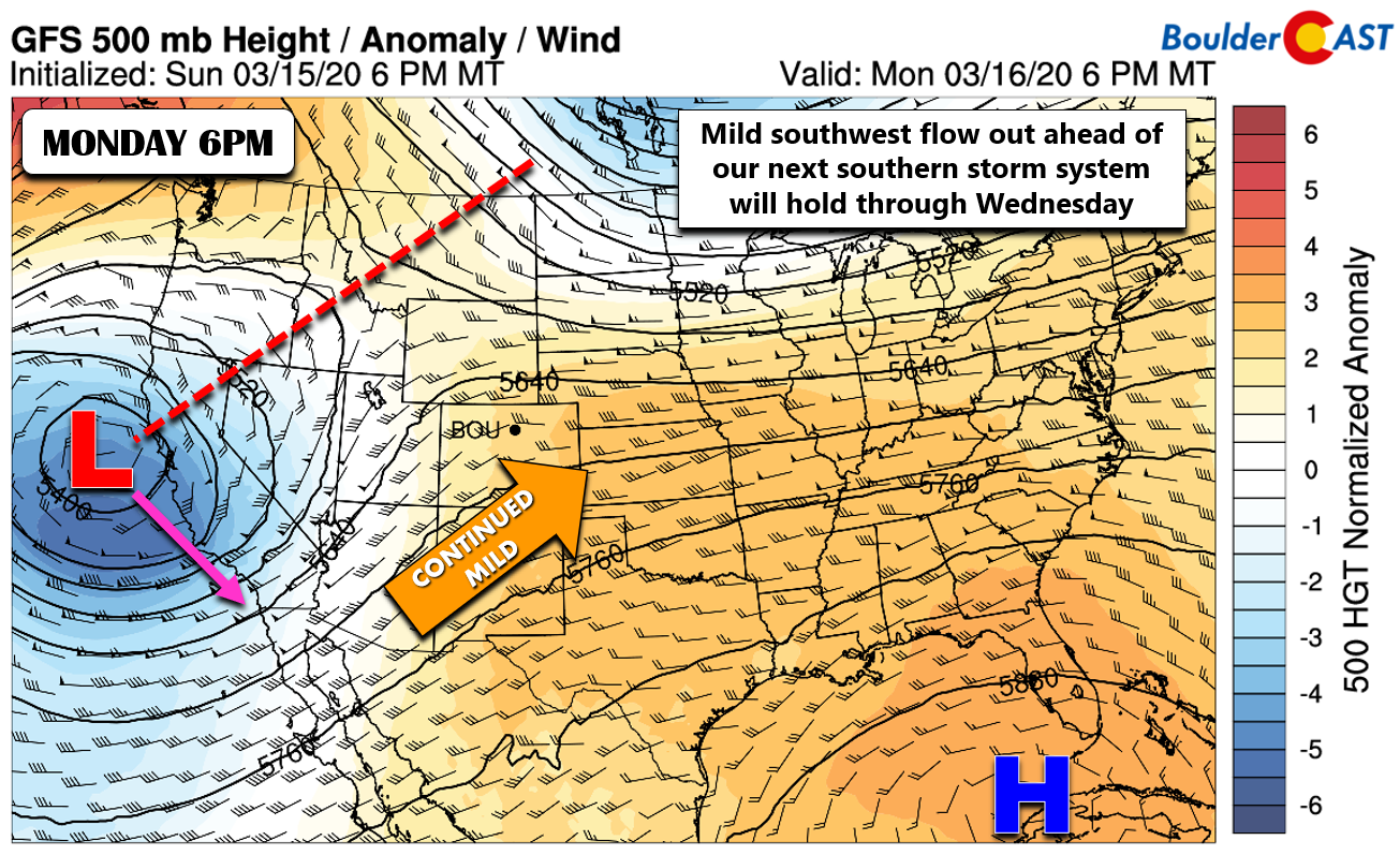
Monday’s GFS model 500mb height anomaly forecast map is shown below, confirming the location off the northern California coastline. Just like the last few weeks, this storm will take a “round-a-bout” track to get to Colorado, but it will definitely become a player for us later in the week. In the meantime, we expect continued southwesterly flow aloft across Colorado into Wednesday which will largely translate into mild and dry conditions.
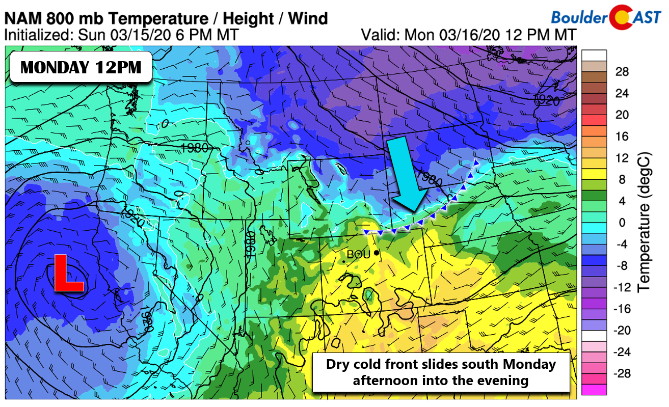
The first forecasting challenge of the week comes in the form a weak cold front making southward progress towards the Front Range as of Monday morning. Westerly downslope flow will likely keep the front from fully impacting the Denver Metro area until after sunset. Before this, expect mostly sunny skies on Monday with increasing clouds. Highs will push into the upper 50’s.
However after dark, chilly low-level easterly flow will take over across the lower elevations. High pressure moving into the Great Plains will help to reinforce and enhance this upslope flow, but the best upslope will be across southeast Colorado. Notice how low-level winds are more southeasterly across the Boulder area, as opposed to almost easterly in southern Colorado (see below). This is just a result of the clockwise flow around the high and the way it is positioned.

NAM sea-level pressure and 6-hour precipitation forecast for Tuesday morning. High pressure fuels upslope and low clouds across Front Range
Under this setup, we do expect low clouds and patchy fog to develop across the Denver Metro area late Monday night into early Tuesday. There could also be some pockets of drizzle mainly in Larimer County. As you can see below, latest model forecasts show temperatures remaining just above freezing so it will mainly be non-freezing drizzle.
In any case, Tuesday will begin with low clouds and cooler weather. If you recall the gloomy conditions in Boulder much of this past weekend, Tuesday morning will be similar. Expect clouds to linger through most of the day, though some peaks of sunshine wouldn’t be surprising before sunset. Highs Tuesday will be cooler due to the socked in clouds. Look for highs in the low to middle 50’s.

Looking down on a sea of clouds this past weekend from the top of Green Mountain, just west of Boulder.
Wednesday will be a day of transition, but we should be able to ink out one final pleasant day before the aforementioned storm system takes over Wednesday night into Thursday. Expect increasing clouds and gusty southerly winds on Wednesday with highs in the lower 60’s. There may be just enough moisture to spawn a few isolated rain showers late in the day. However, we expect most of these would remain across the higher terrain.
A mess of a forecast on Thursday
The California storm system we mentioned earlier will slowly wobble eastward through the early part of the week and arrive on our doorstep sometime Wednesday night into Thursday. We don’t want to get too excited, but the way things are developing, Mother Nature could potentially pummel the Front Range with heavy wet snow. The GFS 500mb vorticity animation below shows the storm’s complicated evolution from Monday through Friday. Not only does the main low pressure shear out into three separate storm systems, another shortwave gets injected from the Pacific Northwest and then all four resulting lows interact and rotate around one another. Yikes! This is going to be a mess of a forecast and one that we will cautiously provide a status update on below.

GFS 500mb vorticity forecast animation for Monday through Friday. A complex cluster of low pressure systems will move into Rockies as the week progresses
With that said, the current guidance is in rough agreement that a strong surface low will form somewhere in eastern Colorado early Thursday and then move eastward through the day. Depending on exactly where this low forms, we could see a prolonged period of moderate upslope-enhanced precipitation across the northeast Colorado with cold enough air for the primary precipitation type to be heavy wet snow. The GFS (shown below) and European models are both indicating the low will form in east-central Colorado, a favorable location for deep upslope to engulf the Front Range. The NAM model solution is noticeably further north and limits the overall upslope and cold air flowing into our area. We need to take any specific model tracks with a grain of salt right now, however.

GFS sea-level pressure and precipitation forecast for Thursday. Will the low form in a favorable location for Front Range upslope precipitation?
Given the favorable storm track, deep moisture, and cold air damming present across the Metro area, the GFS is predicting around 1″ of liquid for us and nearly a foot of snow by Friday morning! The European model is surprisingly similar in its prediction as well.

GFS forecast total precipitation (left) and total snowfall (right) through Friday morning. The Front Range may get slammed.
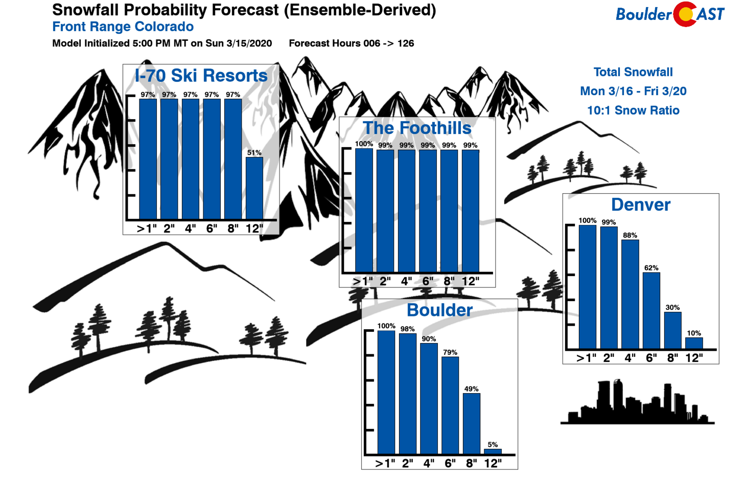
We’re also seeing decent agreement in the ensembles with Thursday’s potential snowstorm. Our latest Snowfall Probabilities have around 80% odds of 6″ or more of snow in Boulder, and 60% odds in Denver (using 10:1 snow ratios). Precipitation will likely begin as rain Wednesday night changing to snow sometime Thursday as much colder air filters southward. The timing of the heaviest precipitation may align with the daytime hours on Thursday, limiting potential impacts of accumulating snowfall on roadways.
Let’s keep everyone’s expectations in-check, though. This is going to be an extraordinarily difficult forecast with low confidence in an exact outcome heading through the week. Every aspect of the forecast at this point is suspect and likely to change between now and Thursday. However, we must say that models are in better agreement than we would expect this far out and for a storm this complex. So there is that! It’s too bad all the ski resorts are closed this week; there should be plenty of powder to go around. As always, we’ll continue to monitor the evolving snowstorm through the week. Stay tuned for updates…
Subscribe to receive email notifications for BoulderCAST updates:
We respect your privacy. You can unsubscribe at any time.
.
Forecast Specifics:
Monday: Mostly sunny in the morning, but skies then turn partly cloudy with highs in the upper 50’s on the Plains and middle 40’s in the Foothills.
Tuesday: Low clouds and patchy fog in the morning, then mostly cloudy with a few peaks of sunshine possible later in the day. Highs cooler in the low to middle 50’s on the Plains and 40’s in the Foothills.
Wednesday: A good deal of sunshine early, then increasing clouds with gusty southerly winds developing. There is a chance of a few rain showers rolling off the higher terrain, but these will be very isolated. Highs in the lower 60’s across the Plains and upper 40’s in the Foothills.
Thursday: Morning rain changing to all snow by early afternoon with gusty north winds. Several inches of heavy wet snow are possible through the day into the night. Highs in the morning in the 40’s falling into the lower 30’s through the day.
Friday: Continued cold with a slight chance of late-day snow showers. Highs in the middle to upper 30’s on the Plains and middle 20’s in the Foothills.
High Country: Mainly dry conditions will prevail across the Mountains Monday and Tuesday. As moist southwest flow increases Wednesday, snow showers will become widespread Wednesday afternoon through the day Thursday as the main series of storm systems pass across Colorado. More than a foot of snow is likely for most of the ski resorts (too bad they are all closed!). Lighter and more scattered snow showers will linger into Friday. Check our PowderCAST page for always-updated weather forecasts for all of the Colorado ski resorts.
Help support our team of Front Range forecasters by joining BoulderCAST Premium. We talk Boulder and Denver weather every single day. Sign up now to get access to our daily forecast discussions each morning, complete six-day skiing and hiking forecasts powered by machine learning, first-class access to all our Colorado-centric high-resolution weather graphics, bonus storm updates and much more! Or not, we just appreciate your readership!
.
Spread the word, share our forecast!


You must be logged in to post a comment.