After a seven-day onslaught of severe weather across northeast Colorado, we’re happy to report that things will be quieting down this week. The weather will be pleasant for Monday and Tuesday, but recirculated monsoon moisture will bring the chance of storms back our forecast from Wednesday on. A slow but steady warming trend will unfold as well.
Dry and cool early on
The recent stretch of severe weather was driven mainly by a stalled frontal boundary which has since gotten its act together and pushed southward into New Mexico.
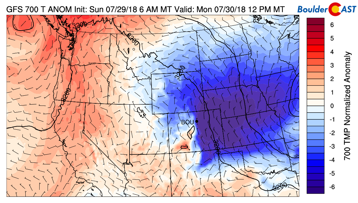
GFS 700 mb temperature anomaly forecast for Monday afternoon showing the unseasonably cool air across eastern Colorado.
Did you feel the refreshingly cool air and gusty winds as the front passed us by Sunday evening around 6:30 PM?
With the front’s passing, drier air has taken over across much of our state. The ridge that hasn’t gone away since mid-June is still parked across the Desert Southwest. Strong, by mid-summer regards, 30 knot northerly winds at 500mb are funneling cooler air into Colorado today (see below).
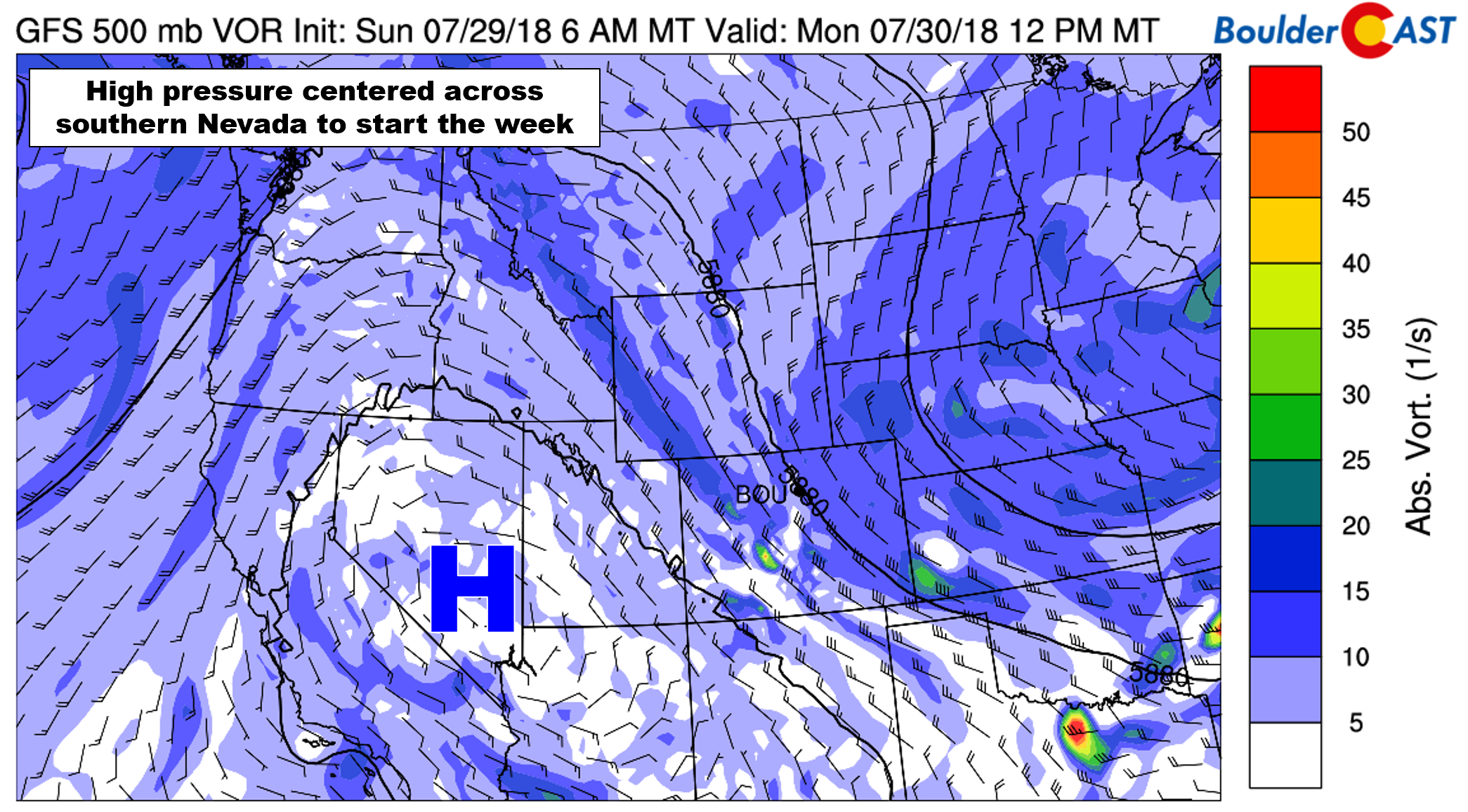
GFS 500 mb vorticity map for Monday
The drier air has significantly stabilized the atmosphere. The GFS forecast CAPE map for this evening shows literally zero instability for the Metro area today (save for a 100-200 J/kg in the Foothills).
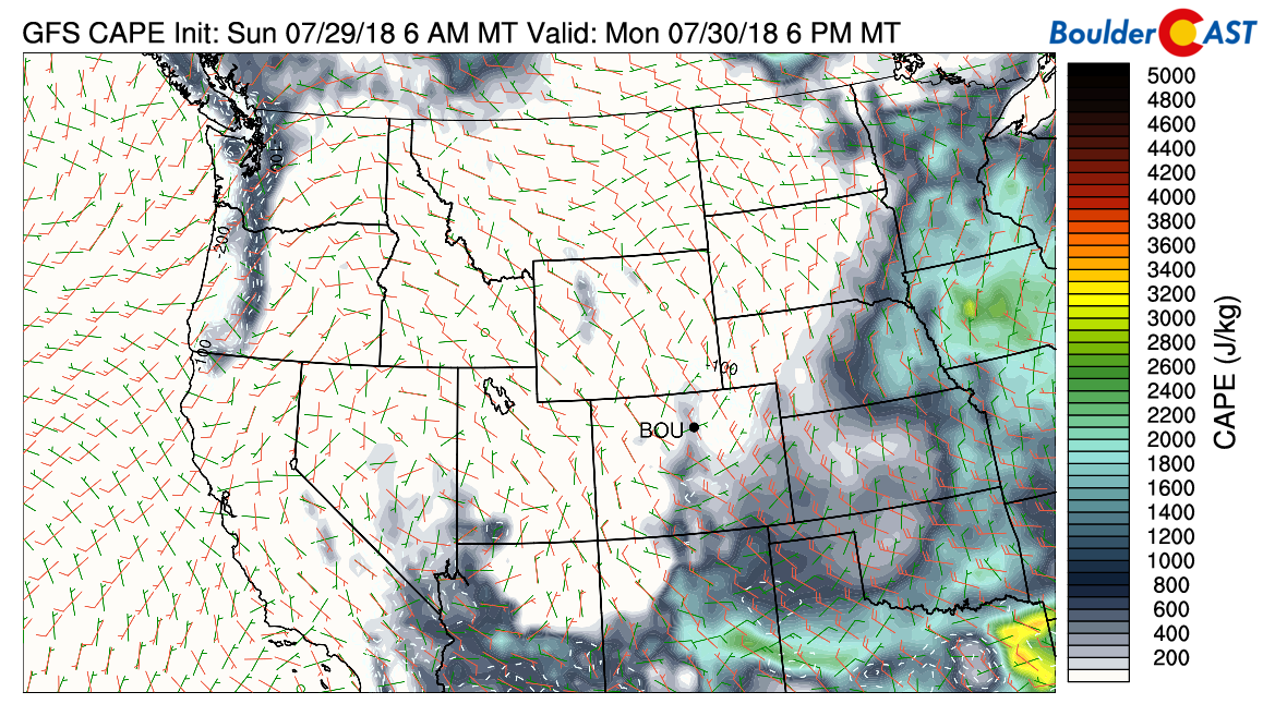
GFS CAPE/shear forecast for Monday afternoon.
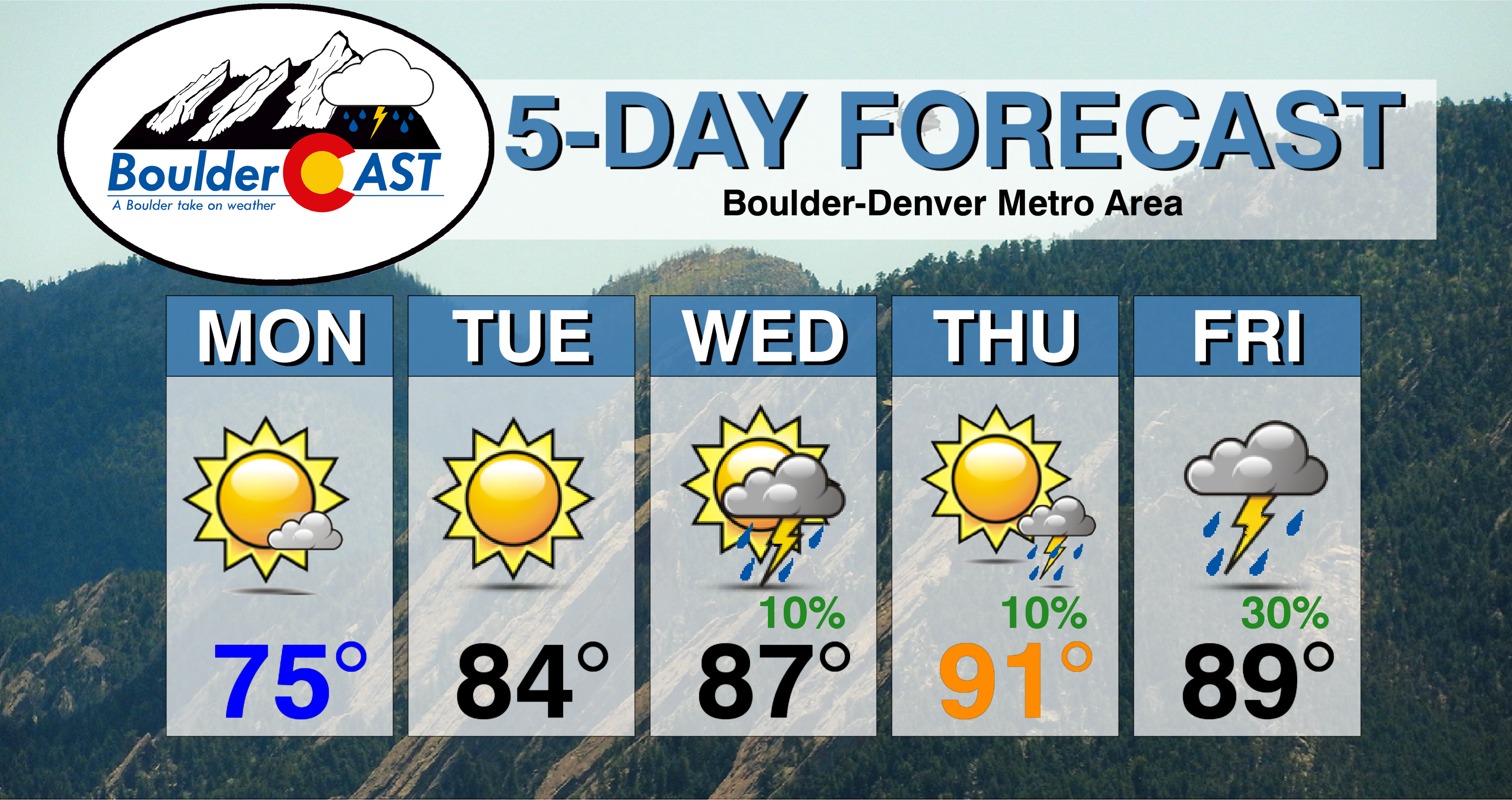
For Monday, skies will be partly sunny with temperatures only reaching into the middle 70’s. This is about 10 to 15 degrees below normal! Tuesday will also be quite pleasant as temperatures will crack back into the 80’s under mostly sunny skies. Tuesday morning will be the last “chilly” one….lows should drop into the low to middle 50’s.
Stagnant high pressure stays in the driver seat
The high pressure that begins the week centered in Nevada by Friday will be a whopping 200 miles further southeast in northern Arizona. While 200 miles may seem like a fair distance traveled for a person on foot in five days, it’s a snail’s pace for a large-scale atmospheric feature! This should not surprising to anyone….the stagnation of this high pressure has been a staple in our forecasts for more weeks that we can count…
Below shows the 500mb pattern on Wednesday (left) and Friday (right). Notice that the ridge will get slightly beaten down by the end of the week as a trough enters the northern Rockies.
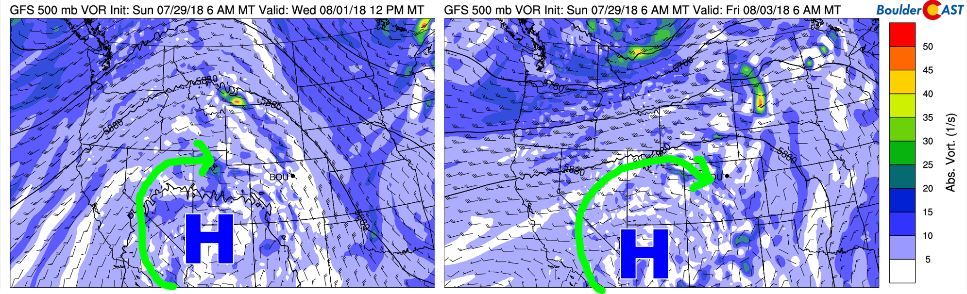
GFS 500 mb vorticity map for Wednesday (left) and Friday (right) showing the stagnant high pressure and recirculated monsoon moisture.
This flattening of the ridge will have two key consequences for us:
- The large and cool fetch of north-northwest flow into Colorado will shorten and eventually turn southwesterly. This will facilitate a gradual warm-up for us as the week progresses with temperatures bumping up a few degrees each day. The dissipation of the trough across the eastern United States will play a role in this as well (no more back-door cold fronts).
- Recirculated monsoon moisture is taking the scenic route and will be back into northern Colorado by Wednesday through the rest of the week. We call this recirculated moisture as it’s not flowing directly into Colorado as would normally be the case with monsoonal flow. Nonetheless, rain will return to the forecast on Wednesday and continue in meager doses through the upcoming weekend.
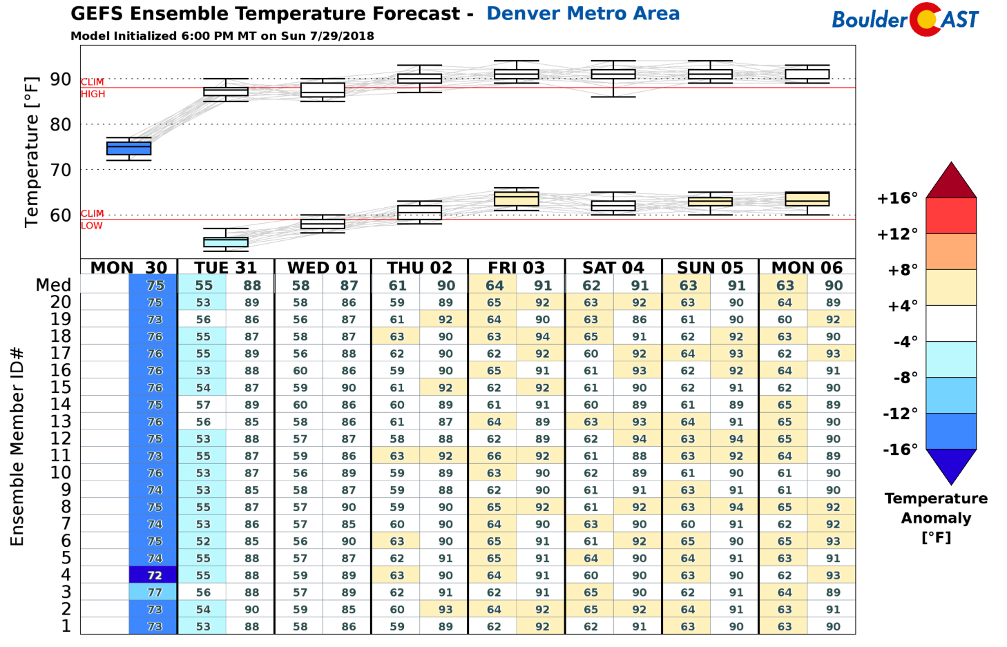
The slow warming trend is captured well in the GFS ensemble temperature forecast below. Mid 70’s on Monday will give rise to the low 90’s by late week.
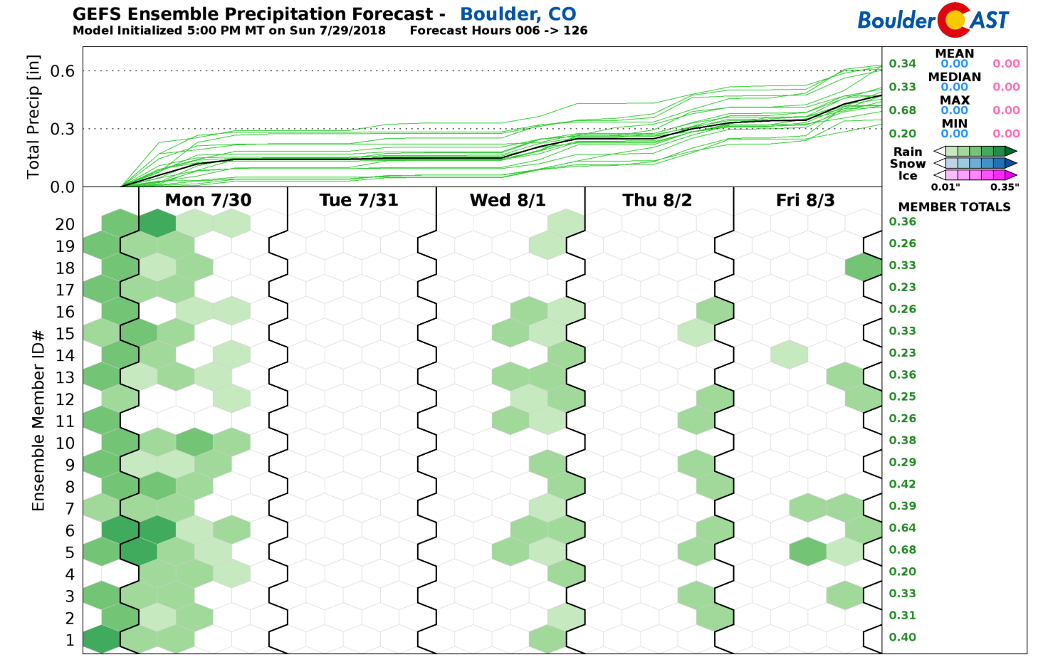
We like the look of the GFS ensemble precipitation forecast for the week as well. It shows nicely when there will be chances for rain….Wednesday, Thursday, and Friday…..and also sheds light on the disappointingly low potential each day. Ignore the rain showing up on Monday….that is already behind us at this point.
Enjoy the quieter weather moments this week!
Forecast Specifics:
Monday: Cool in the morning, then partly cloudy and strikingly pleasant. Highs in the mid 70’s across the Plains and mid 60’s in the Foothills.
Tuesday: Starting out chilly in the morning, then mostly sunny and warmer. High temperatures in the middle 80’s for the Plains with lower 70’s in the Foothills.
Wednesday: Morning sunshine, then partly cloudy with isolated afternoon and evening thunderstorms. High temperatures in the upper 80’s across the Plains with mid 70’s in the Foothills.
Thursday: Partly to mostly sunny with isolated afternoon and evening thunderstorms, mainly south of Denver. Expect highs in the lower 90’s for the Plains and in the upper 70’s in the Foothills.
Friday: Mostly sunny skies transitioning to increasing clouds and widely scattered thunderstorms in the afternoon and evening. Highs for the Plains near 90 degrees, with upper 70’s in the Foothills.
Weekend Outlook: The late-week pattern will continue into the weekend. Expect temperatures to remain in the realm of 90 degrees with isolated storms for the lower elevations.
High Country: Dry and pleasant weather will be in place Monday and Tuesday thanks to the cleansing of atmospheric moisture. However, isolated to scattered storms return to the forecast Wednesday through Friday, especially for southern Colorado. At this time, Friday looks to be the wettest day statewide. Check out SummitCAST for twice daily updated forecasts for more than 120 Colorado hiking destinations!
DISCLAIMER: This weekly outlook forecast was created Monday morning and covers the entire upcoming week. Accuracy will decrease as the week progresses as this post is NOT updated. To receive daily updated forecasts, subscribe to BoulderCAST Premium.

.
Share our forecast!


You must be logged in to post a comment.