The last week of July will feature very seasonal weather in the Front Range as a stationary ridge of high pressure remains across the southern Rockies. While initially suppressed, monsoon moisture will make its way back into Colorado by mid-week. As a result, hot and dry conditions will transition stormier as the week wears on.
The break from the monsoon is brief
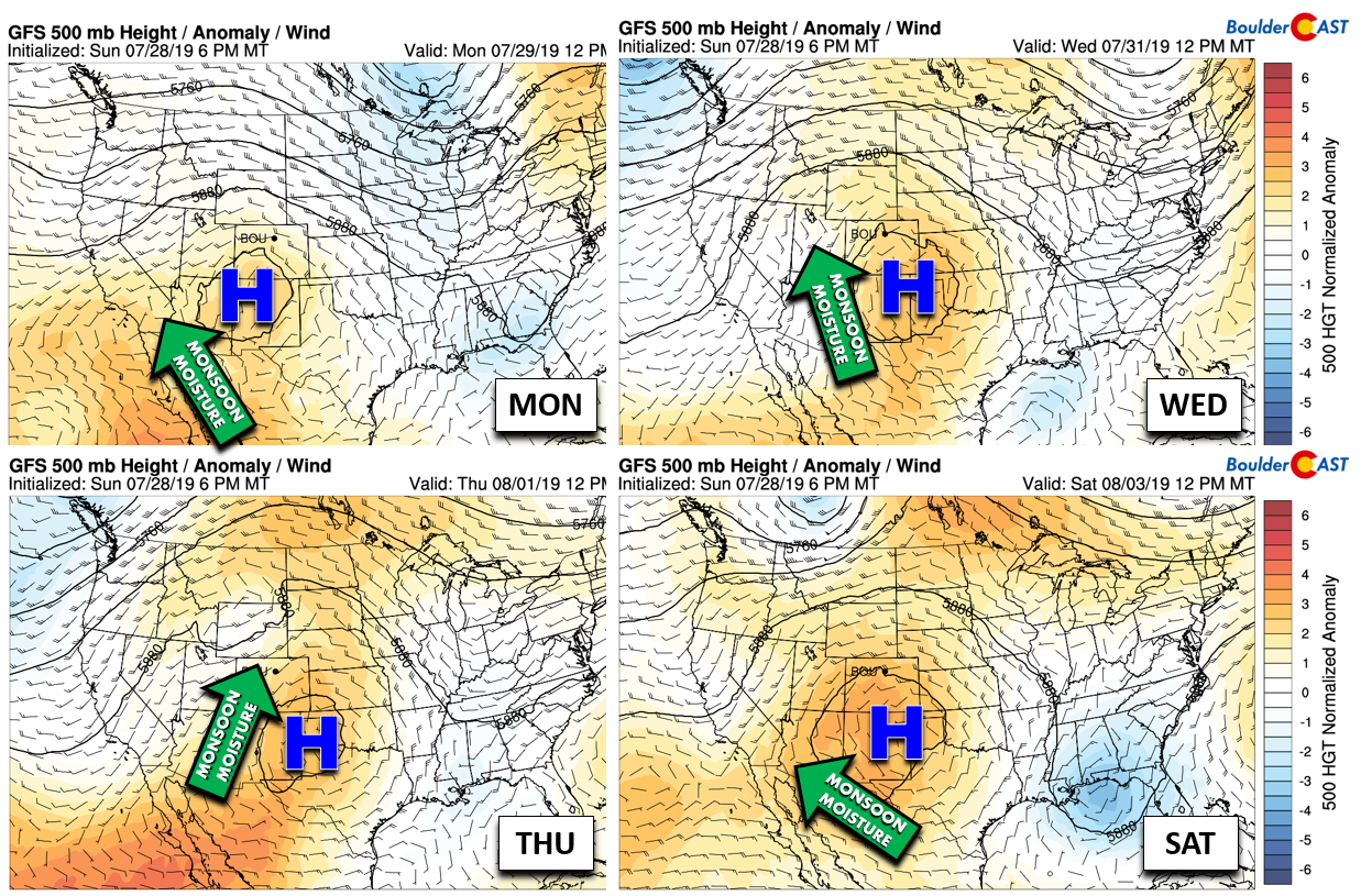
As we move through the upcoming week, the large-scale weather pattern will change very little across the Inter-Mountain West. A ridge of high pressure at 500 mb will remain relatively stationary and possibly strengthen a little as the week progresses.
As you can see in the graphic below, on Monday the center of the high will be along the New Mexico and Arizona border, with dry west-northwest flow across the Boulder area. The deepest pool of monsoon moisture has been suppressed into southern Arizona and Mexico. By mid-week, however, the high will move a bit eastward into the Texas Panhandle. This will open the floodgates so-to-speak, allowing for much better monsoonal flow into the Four Corners region and eventually northeast Colorado. As such, we’ll begin the week on the dry side, but the threat of storms will ramp-up quickly come Wednesday and Thursday.
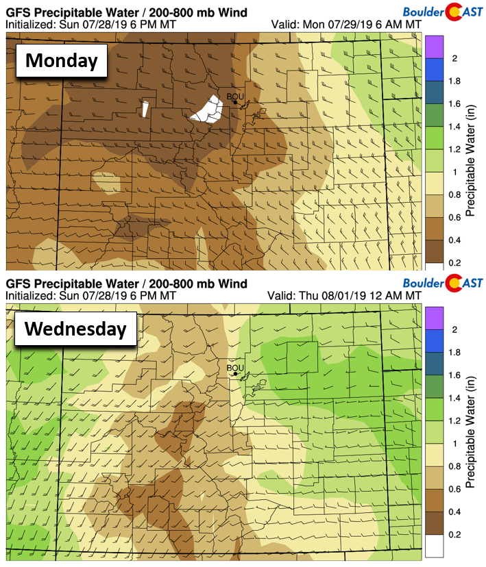
The animation of moisture anomaly below from the American GFS model shows the northward surge of sub-tropical moisture expected this week. Watch the explosion of positive anomalies (green) northward into Nevada, Utah, Wyoming and eventually Colorado.
Models are showing precipitable water values in Denver around 0.6″ Monday morning…well below normal for late July. The increase in moisture by mid-week is clear though, with moisture expected to surge over 1″ by as early as Wednesday afternoon.
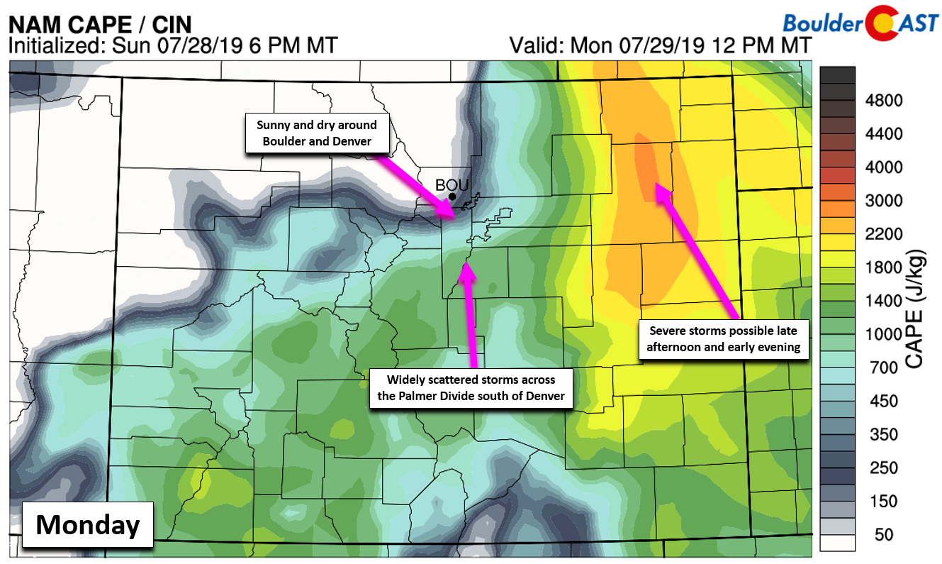
All of this will translate into a hot and dry beginning to our week with sunny skies Monday and highs in the lower 90’s for Boulder and Denver area. Further east across the farmy-Plains, a stalled frontal boundary will facilitate the development of a few severe storms late Monday afternoon and early evening. Run-of-the-mill isolated thunderstorms will develop over the Palmer Divide but remain south of Denver thanks to the northwesterly steering flow.
Tuesday will remain very hot, but moisture does increase a little (though not necessarily at the surface). This will bring the chance of high-base storms, albeit slight, back into our forecast. Look for highs in the middle to (dare we say) upper 90’s with isolated late-day storms. We put the chance only around 10%. Brief gusty outflow winds accompanied by virga will be possible thanks to the dry lower atmosphere.
Wetter Wednesday and beyond
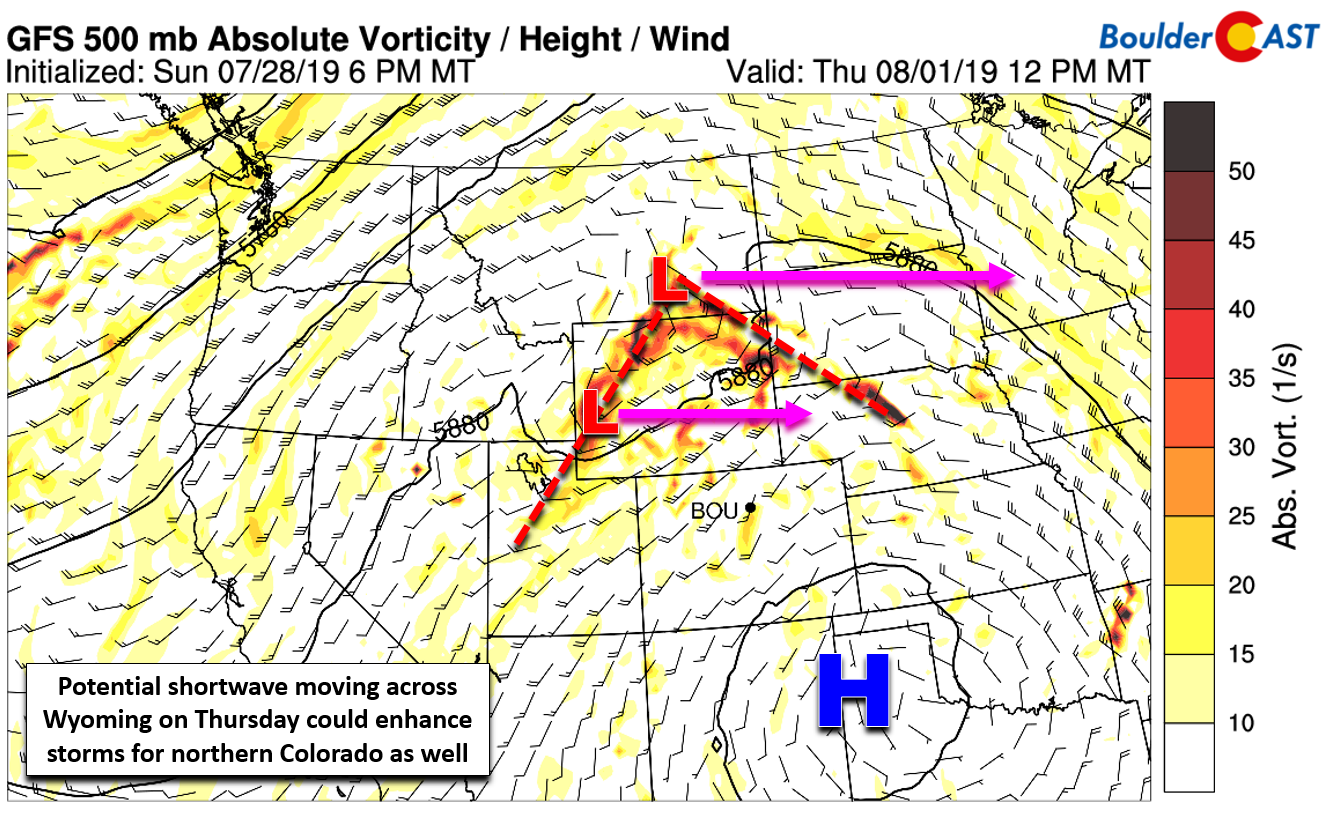
With the aforementioned resurgence of moisture expected around mid-week, storm chances will go up alongside temperatures falling back into the upper 80’s to lower 90’s given the increased cloud cover. If the models are correct, a shortwave will pass during the day Thursday along the northern edge of the ridge. While the main focus will be across Wyoming, this shortwave should provide additional lift and instability to northern Colorado as well. Thus, our best chance of moisture and lift overlapping will be on Thursday…and so too will be our best odds of storms.
Friday will be slightly warmer and drier, but at least isolated to widely scattered coverage of storms is likely. Highs will return to near 90 degrees.
A quick check on the tropics
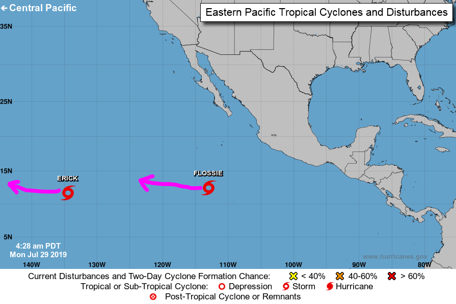
While mainstream media coverage tends to focus on the Atlantic for tropical cyclone development (and rightfully so), at BoulderCAST we keep our attention focused on the eastern Pacific Ocean as these are the only systems that can impact Colorado. Currently we have two active tropical storms, Erick and Flossie. While both are forecast to become hurricanes in the next day or so, they will keep a westward track and thus are not a concern for Colorado. With a weak El Niño still holding, the tropical Eastern Pacific should remain active for the rest of summer into early fall which will definitely be something to keep an eye on.
Have a good end of July and beginning of August!
Forecast Specifics:
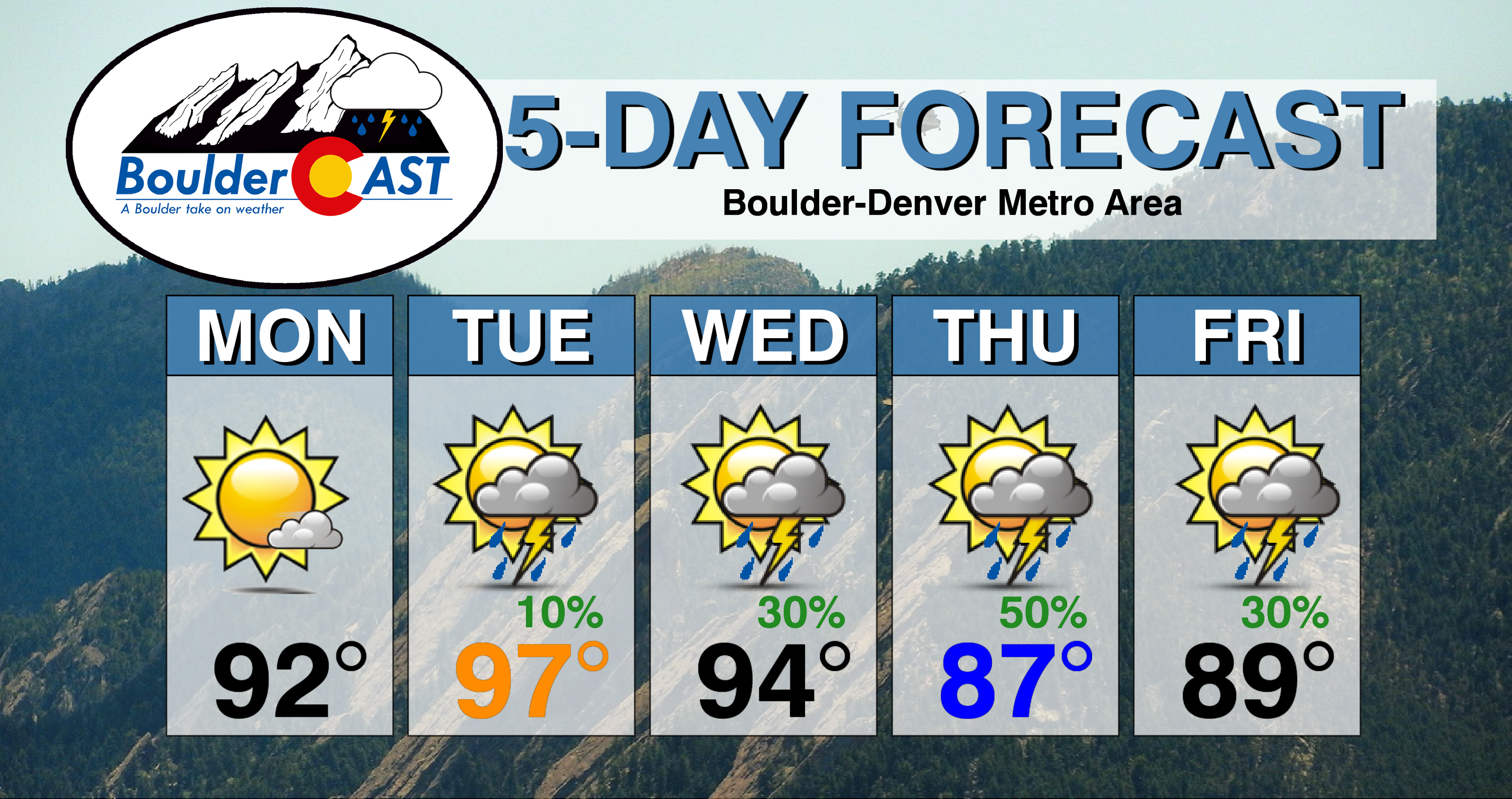
Monday: Sunny and dry with highs in the lower 90’s across the Plains and in the upper 70’s in the Foothills.
Tuesday: Morning sun with a few afternoon clouds and isolated high-base thunderstorms. Light rain and brief outflow gusts will be possible. Hot with high temperatures in the middle to upper 90’s for the Plains with lower 80’s in the Foothills.
Wednesday: Morning sun giving way to increasing clouds and widely scattered afternoon and evening thunderstorms. Highs in the low to middle 90’s across the Plains and near 80 degrees in the Foothills.
Thursday: Slightly cooler with scattered showers and thunderstorms developing in the afternoon and evening. This day will offer our best chance of rain and heavy downpours. Highs in the mid to upper 80’s on the Plains and middle 70’s in the Foothills.
Friday: Morning sun turning partly to mostly cloudy in the afternoon with widely scattered thunderstorms developing. Highs temperatures near 90 degrees on the Plains and middle 70’s in the Foothills.
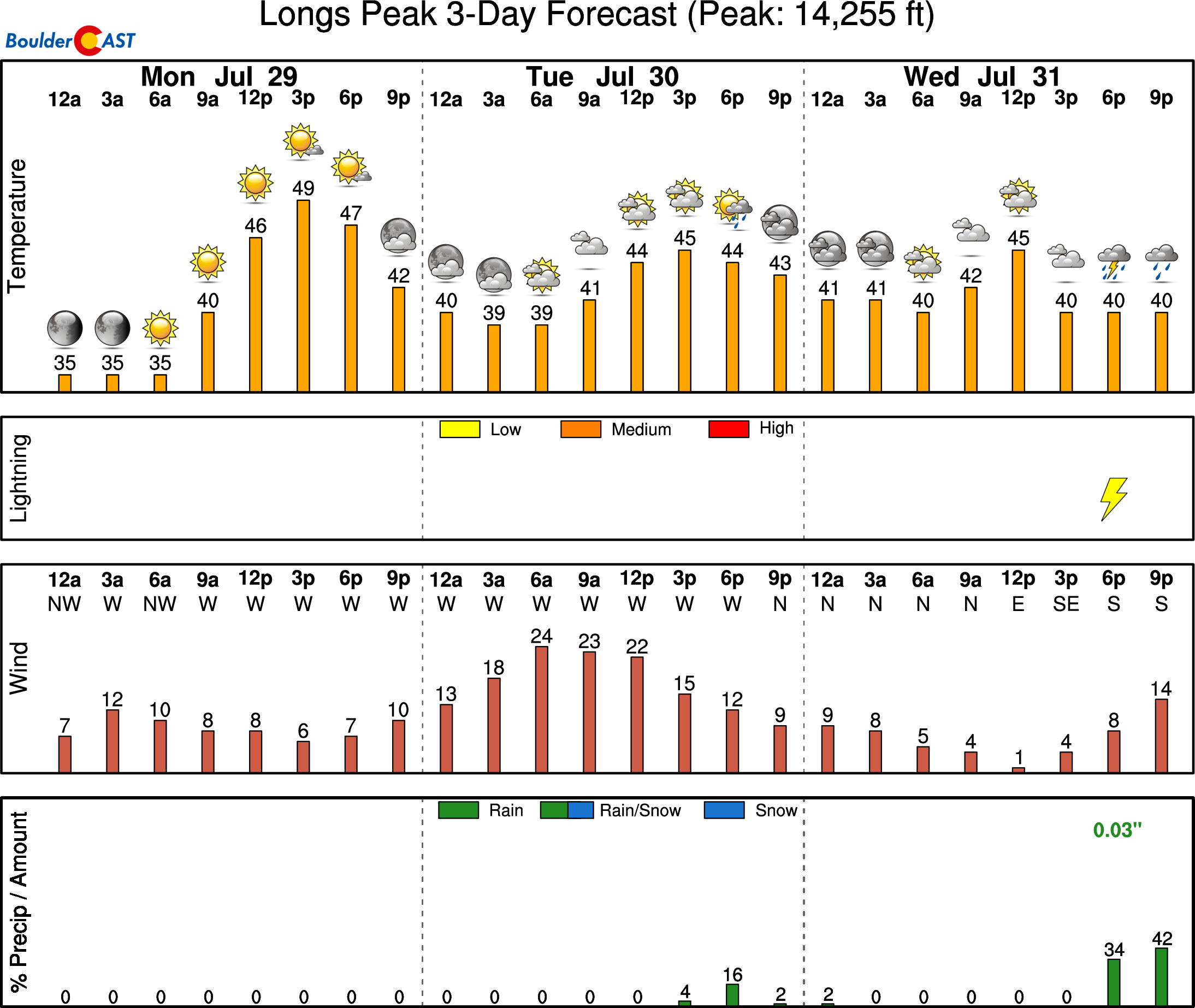
High Country: Dry air early in the week will translate into only isolated storms across the Mountains to begin the week, mainly south of Interstate 70. However, a deep influx of monsoon moisture will lead to more widespread late-day storms Wednesday through Friday. Visit our SummitCAST page for updated forecasts for more than 120 Colorado mountain destinations, including all of our state’s majestic 14ers.
DISCLAIMER: This weekly outlook forecast was created Monday morning and covers the entire upcoming week. Accuracy will decrease as the week progresses as this post is NOT updated. To receive daily updated forecasts from our team, subscribe to BoulderCAST Premium.

.
Spread the word, share our forecast!


