
Look for BIG changes in the weather for the week ahead, with cold, snow, and windy conditions the story as Arctic air invades the state! The High Country is slated to see another round of snow, with the Plains also on track to get their chance by Tuesday evening. How much can we expect and how cold will it get? Read on for our full weekly outlook.
Cold weather on the way…
Below shows the current upper-level jet stream flow for today. There is a broad trough over Montana with the jet stream sagging southward across Nevada, Utah, Colorado, and into the Upper Midwest. This upper-trough will be responsible for bringing down very cold air later tonight, tomorrow, and Wednesday with high temperatures in the teens by midweek…
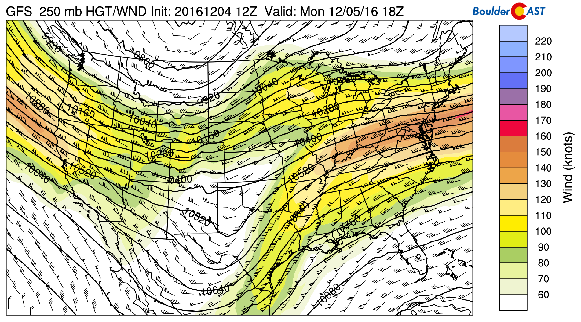
GFS 250 mb upper-level wind speed and jet stream today
The upper-level jet today is producing west-northwest winds over the High Country, aiding is some preliminary snowfall in northwestern Colorado, and even the Front Range Mountains. The moisture is evident with relative humidity values in excess of 80%, indicating upslope flow and snowfall in the mountains.
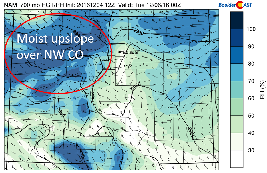
NAM 700 mb relative humidity and winds in the High Country today
The GFS (below) predicts anywhere from 2-4″ of snow across Steamboat, Winter Park, Vail, and Eldora. However, we think a little more is possible, say 3-7″ in these areas, given the strong westerly upslope flow over the High Country. If you’re skiing today, bundle up as highs will only be in the teens to single digits! A more detailed ski forecast can be found on our PowderCAST page!
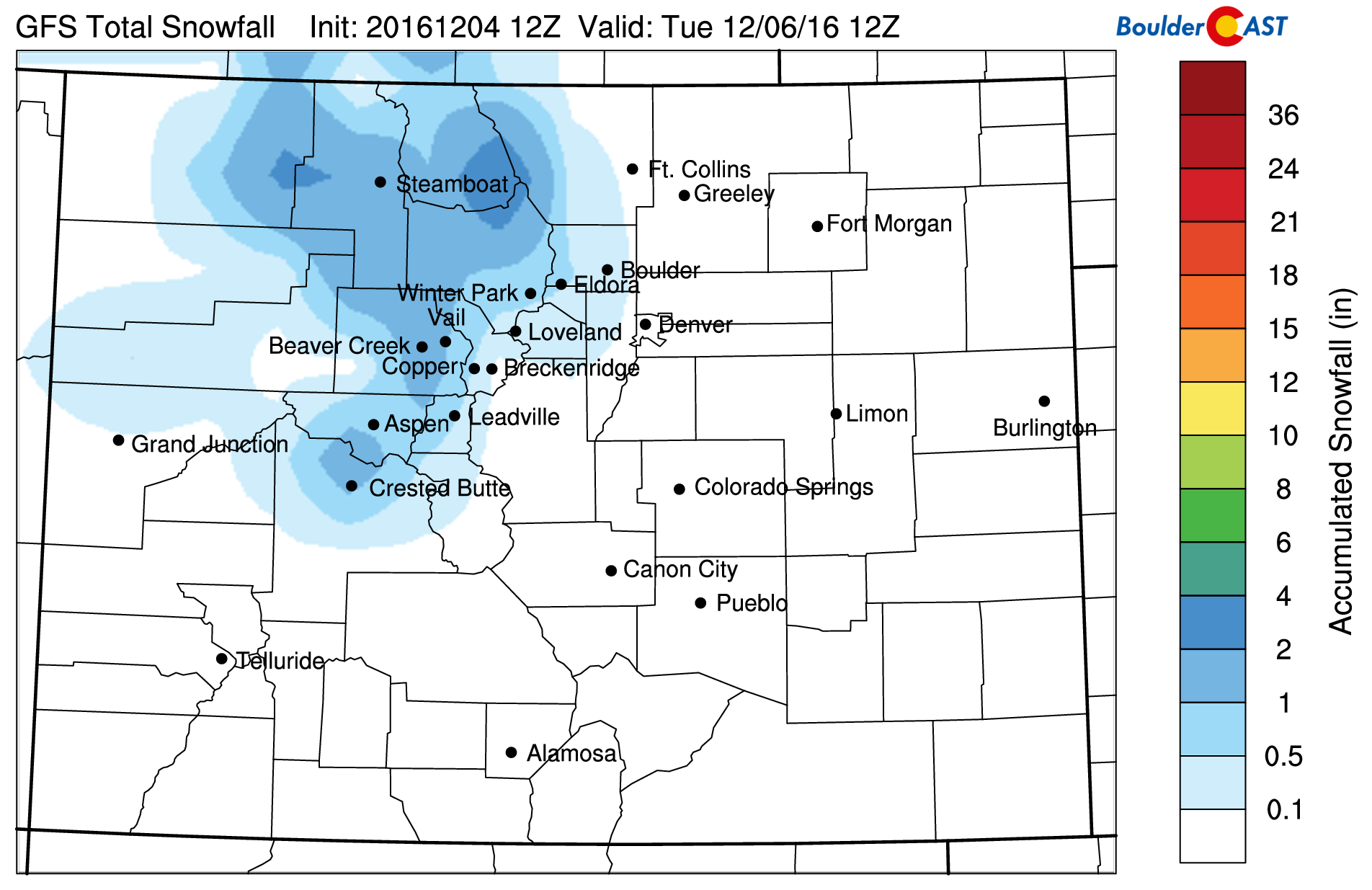
GFS total snowfall in the mountains today
For the Plains, we can expect a quick warm-up on this Monday to near 50 degrees by the lunch-hour before a cold front arrives. Westerly winds will be quite gusty to start the day, at times gusting to 35 mph, with up to 60 mph in the Foothills.
Below shows the low-level winds and temperatures over Colorado today. Notice the tightly packed contours near Boulder and the Foothills, with winds approaching 40 mph. This downslope flow will aid in the warmth early in the day.
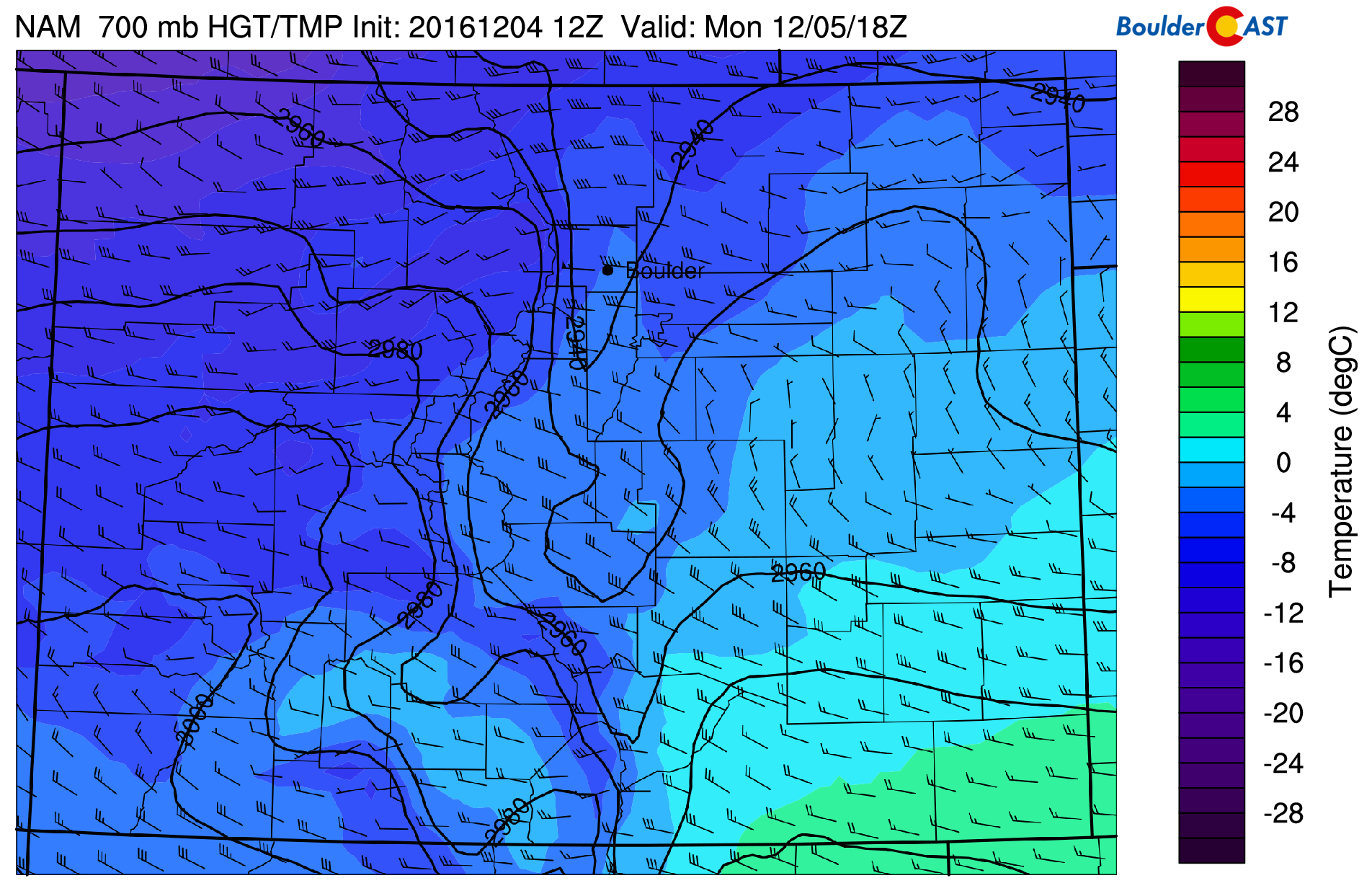
NAM 700 mb temperature and wind today
Temperatures will fall into the 40’s by mid to late afternoon, and eventually the 30’s and 20’s overnight. This is all in response to cold front sagging south from Wyoming. This is evident below, where the orange line indicates the front by late afternoon. However, expect the “real” cold air to filter in overnight!
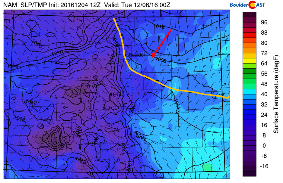
NAM surface temperature, wind, and pressure, as well as the cold front location later today
Tuesday: cold and snowy
Tuesday will be down-right cold and snowy. Below show a time-height plot of temperatures (red contours), winds (barbs), and relative humidity (shaded blue colors) for the next 3 days. Focus your attention on the area circled in red. The wind barbs show northeasterly flow, indicating the cold front mentioned earlier, as well as upslope conditions from Tuesday afternoon into Wednesday morning. This will aid in snow chances for the Plains and Foothills. Models are showing the cold air mass to be as much as 12 degC colder than Monday. We expect, as a result, only middle 20’s for highs Tuesday!
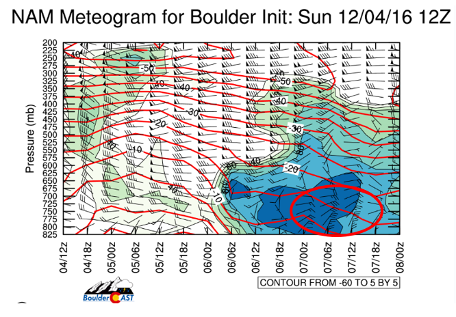
NAM meteogram, indicating temperatures, winds, and relative humidity for the next 3 days
As for our snow chances, we will post our final snow prediction later Monday evening (including our snow map). For now, here is a general overview of the situation at hand….
On Tuesday, we will be under the influence of a fast moving low pressure system, indicated below. With that, upslope will develop over the High Country, Foothills, and Plains. However, there is still uncertainty in the exact track of the system, which will influence how much snow the Plains may receive.
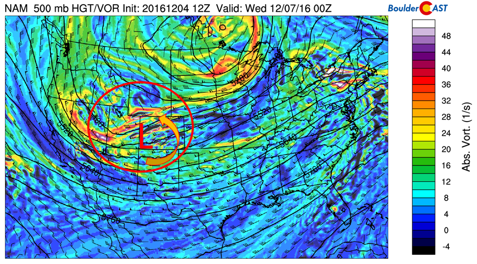
NAM mid-level absolute vorticity and low pressure system on Tuesday. Arrow indicates upslope flow on Plains
The GFS, NAM, Euro, and Canadian (below) are now more consistent to develop snow for the region Tuesday late afternoon/evening than they have been in the last few days.
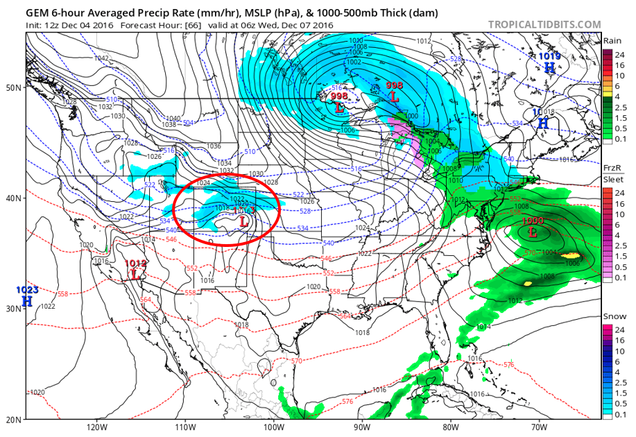
Canadian model forecast precipitation type for Tuesday evening (area circled in red). Blue indicates snowfall
The GFS ensemble plume forecast, while it entertains decent uncertainty, has a mean precipitation (black line) around 0.35″ of liquid for the Denver Metro area. The GFS latest deterministic run (blue line) is similar.
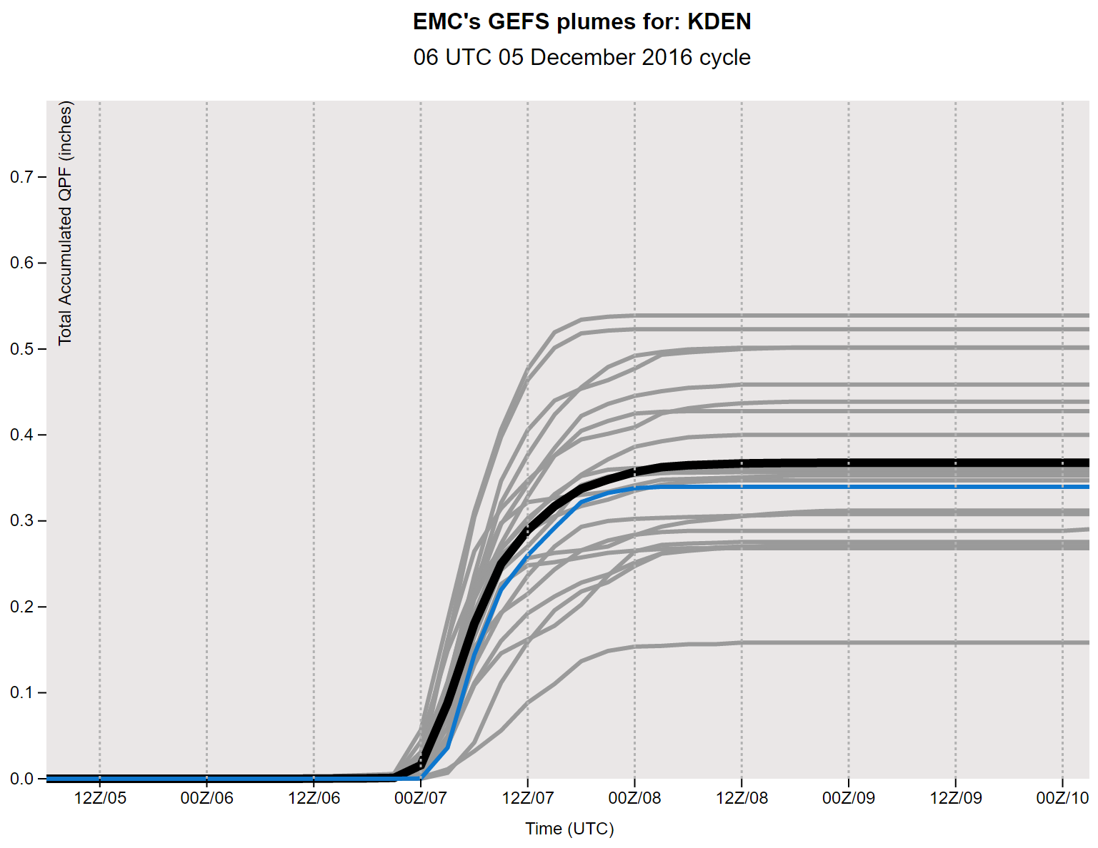
GFS Ensemble plume forecast precipitation for the Denver Metro area Tuesday into Wednesday
The NAM model indicates snow-to-liquid ratios of 15:1 (below left plot), meaning that 1″ of liquid water would produce 15″ of snow. This ratio seems reasonable given the cold temperatures. Using a 15 to 1 snow-to-liquid ratio and an average liquid precipitation of 0.35″ would point to ~5″ of snow for the Plains. The potential is definitely here for a decent snow event, but stay tuned for our final forecast later this evening! We’re still too concerned about some variations in the models right now.
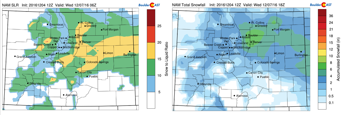
NAM snow-to-liquid ratio (left) and total snow Tuesday into Wednesday across Colorado
Here’s what we know:
- Tuesday will see highs starting out in the middle 20’s, dropping to lower 20’s or teens by evening.
- Snow looks to start during the afternoon
- Snow would be heaviest Tuesday evening and night, tapering off Wednesday morning
- Some uncertainty in amounts, but potential for 3-6″ of snow
- High Country could see 3-8″ of additional snowfall over Monday’s amounts (6-15″ total by Wednesday)
- Big drop in temperatures, with below zero temperatures Wednesday night area-wide
Wednesday and Thursday is cloudy and cold
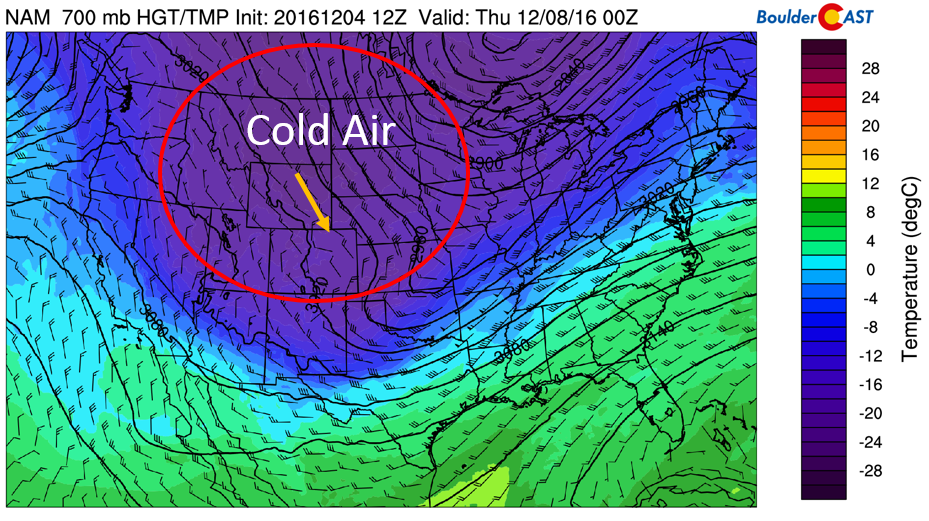
Wednesday the storm system pulls east and behind it very cold air settles down from Canada. Mid-level temperatures will drop down to -18 degC. This coupled with potential snow on the ground and cloud cover, will point to highs struggling to get out of the teens on the Plains. Wednesday night, high pressure settles in, resulting in clearing skies, which should lead to overnight lows below zero, the coldest air we have seen so far this winter!
On Thursday, we can expect just a slight warm-up. With the cold air still in place, highs only in the low 20’s are to be expected.
NAM mid-level temperatures for Wednesday
Friday ends warmer but snow continues in High Country
On Friday, westerly downslope flow, similar to Monday, will exist on the Plains. We may see another gusty day for the Denver Metro as a result, again in excess of 30 mph from the west. This will, however, warm the region up to the 40’s once again and melt us out from the cold, which will be nice!
Don’t expect the High Country to follow suit though! Below shows the mid-level flow and relative humidity for Friday. The area circled in red indicates another pulse of moisture impacting Colorado, all thanks to a persistent polar jet stream oriented perpendicular to Colorado. This is a very favorable position for ski snow. What a great week to hit the powder! The only downside if you are skiing is that it will be windy and cold.
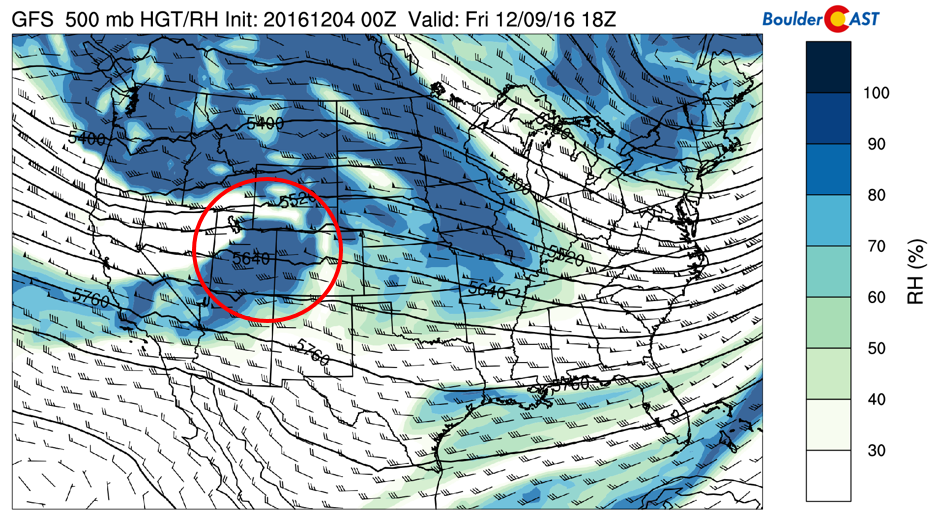
GFS mid-level relative humidity, heights, and wind pattern for Friday
Extended to stay active
The extended outlook shows a continued push of the polar jet stream from the Pacific Northwest punching into Colorado over the weekend and into next week. This pattern initially favors continued mountain snowfall and downslope wind events for the Plains, as well as intrusions of cold Arctic air. However, it could lead to another snow storm for the Plains. Either way, it’s going to bring the moisture the Front Range definitely needs!
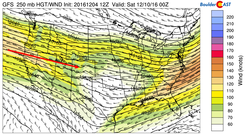
GFS weekend Jet Stream pattern over the United States
Forecast Specifics:
Monday: Partly sunny with gusty winds in the morning, at times up to 35 mph and 50 mph in the Foothills. Light snow will be possible in the morning for the Foothills above ~9.000 feet, with up to 2″ of accumulation. Highs near 50 degrees on the Plains and upper 30’s in the Foothills. Temperatures dropping later in the day and evening.
Tuesday: Mostly cloudy skies and colder with middle 20’s on the Plains and middle teens in the Foothills. Snow looks to develop by late morning/afternoon, continuing into the evening and overnight. The potential could exist for 3-6″ of snow for in many locations.
Wednesday: Very cold with snow showers tapering off late morning or early afternoon, then mostly cloudy skies. Highs only in the middle teens for the Plains and single digits in the Foothills.
Thursday: Partly cloudy and cold. Highs in the low 20’s on the Plains and lower teens in the Foothills.
Friday: Partly sunny and much warmer, with potential for gusty west winds. Highs possibly reaching the upper 40’s.
High Country: Snow will be story for the week in the mountains. Expect a general 3-7″ over west and northwest Colorado Monday. Another 3-7″ is possible Tuesday into Wednesday. After a break in the snow on Wednesday and Thursday, another system moves in for Friday and the weekend. Expect windy and cold weather at the ski resorts this week.
Extended: The forecast models are indicating that the polar jet stream will continue to remain south over the United States, continuing the trend for cold intrusions, as well as mountain snowfall. It’s not clear whether the Plains will get in on the action in regards to snow, but time will tell…
Mon
Tue
Wed
Thu
Fri


Temperature
51
25
14
21
47


Precip Chc (Plains)
0%
60%(pm)
30%
0%
0%


You must be logged in to post a comment.