
From record-setting heat to potential blizzard conditions, this week has it all for northeast Colorado. The extent of wintry impacts Wednesday into Thursday will hinge on the track of the incoming storm, which as of now, remains shrouded in uncertainty. Either way, summer will shift to winter in the blink of a eye mid-week.
Warm early in the week
For the first part of the week, upper-level ridging and warm southwesterly winds will lead to summer-like weather across the southern Rockies.
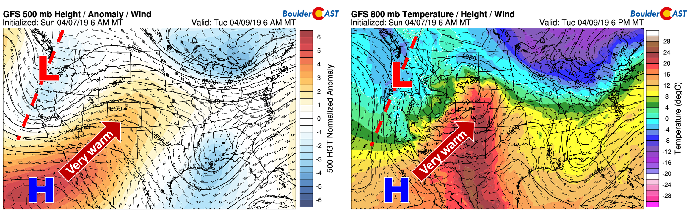
GFS 500 mb height anomaly forecast (left) and 800 mb temperature/wind forecast (right) for Tuesday
Monday and Tuesday will successively be the warmest days of 2019, with highs Monday in the middle 70’s and then near 80 degrees on Tuesday. Tuesday in particular has the chance to set new record highs for many cities across the Front Range. In Boulder, the record high for April 9th is 78 degrees.
Winter returns mid-week
The warmth won’t last forever. In fact, it won’t last long at all! We already know when it will likely come to an end as an approaching winter storm ushers in much colder air to the region on Wednesday!
The 500mb height anomaly animation below shows the warm, early-week ridge shifting eastward and an expansive trough moving into Colorado on Wednesday. A deep closed-low is expected to strengthen somewhere across eastern Colorado or Kansas come Wednesday into Thursday.
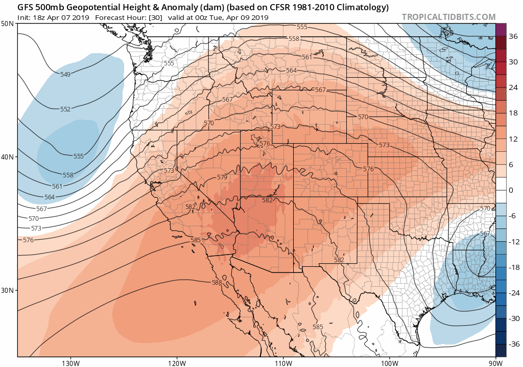
GFS 500 mb height anomaly animation from Monday through Thursday showing the developing storm system and exiting ridge
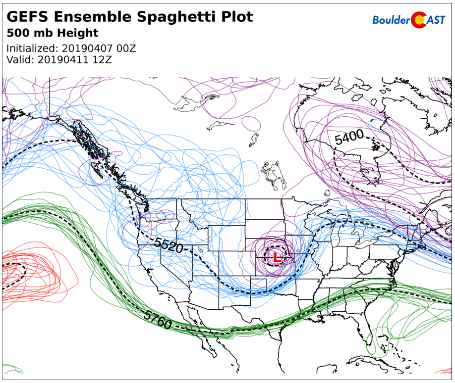
Unfortunately, the track of the main storm system is not lining-up well for significant precipitation or snow in the Front Range. As you can see in the animation above, the storm tracks directly across the Colorado and Wyoming border. The Euro, GFS, and NAM models all agree quite closely on this track. There is some slight wobble in the ensembles, as expected (see below). Some runs do bring the storm just a shade further south which would be slightly more favorable for our region. However, none are truly as far south as we would like.
The problem with this northern track is that resulting wind direction across northern Colorado ends-up being generally northwesterly, a downslope wind for us. This inhibits precipitation, but also provides warming for the northern and western Metro area. This time of year, we need all the cooling we can get for snow! Notice that winds near 10,000 feet elevation are predicted by the GFS model to be northwesterly in our area during the day Wednesday and Wednesday night (below). The juicy easterly upslope remains further north in Wyoming. This creates uncertainty in both HOW MUCH precipitation we see, but also in the CHANGE-OVER TIMING from rain to snow.
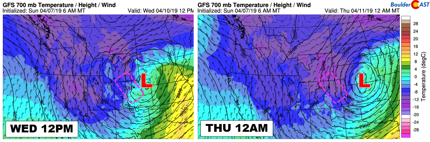
GFS 700 mb temperatures and winds for Wednesday afternoon (left) and night (right)
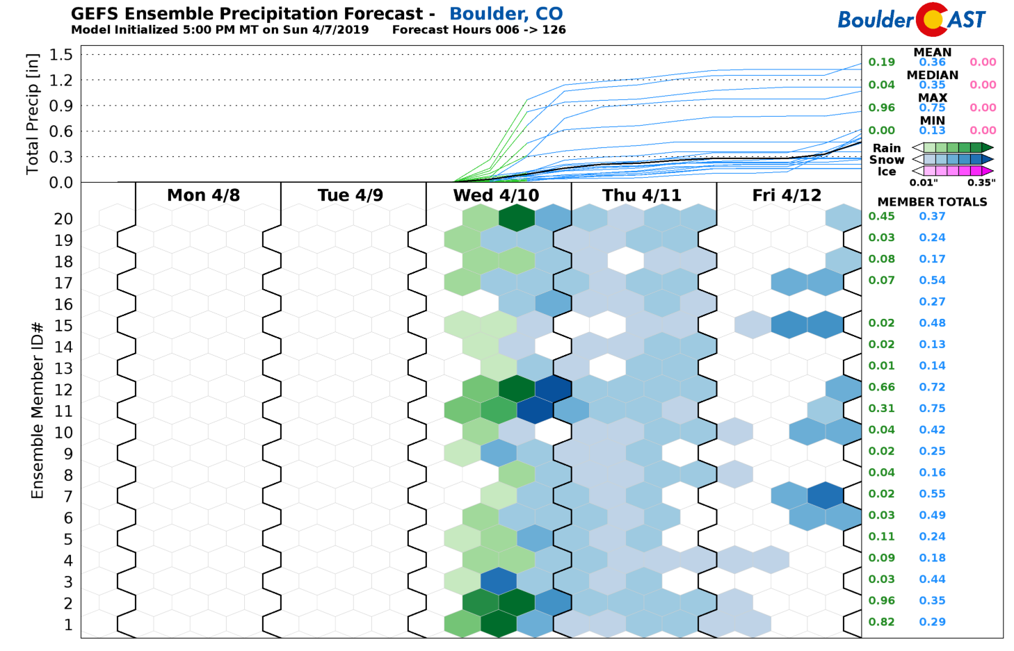
There is still enough indication from some model runs and some ensemble members that we’re not yet declaring a total miss for this storm. There is definitely a chance that the incoming trough slows down and digs a little further south bringing more favorable upslope to the Front Range. In the GFS ensemble precipitation plumes below, you can probably guess which specific members are predicting this more southern track. Yep…members 1, 2, 11, 12 and 20, the ones that clearly predict way more precipitation than the other 15 members for Boulder.
We’ll also need to keep an eye on the intensity of the developing surface low across eastern Colorado. The models have been trending stronger in recent runs. The latest GFS run, for example, predicts a central pressure of 976 mb. The Euro model….979 mb. While not quite as strong as the epic bomb cyclone last month, this is comparable to a Category 2 hurricane and will likely create blizzard conditions somewhere across eastern Colorado, Nebraska, and Kansas Wednesday and Wednesday night.
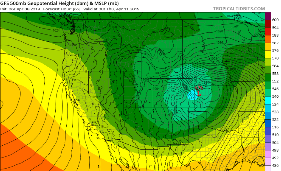
GFS forecast 500 mb heights (colors) and surface pressure (black lines) for Wednesday evening. A strong, 976mb surface low is indicates in western Kansas
Despite the lack of clarity, the take-away for now is that BIG weather changes are incoming….
- The 24-hour temperature change from Tuesday afternoon into Wednesday afternoon will be close to 50 degrees in Boulder and Denver –Near 80 to near 30!
- Wednesday’s high will be in the upper 40’s to lower 50’s and occur in the morning hours
- Precipitation develops by late morning beginning as scattered rain showers. Given the strong forcing, some thunder is possible as well
- Colder air filters in throughout the day changing rain to snow by late afternoon or early evening. North-northwesterly downslope could delay the change-over to snow in Boulder, Longmont, and Fort Collins areas
- The best chance of accumulating snow for the lower elevations will be Wednesday evening and night. Most of us should indeed see snowflakes. Accumulation potential remains to be determined, but could anywhere from a dusting to several inches
- Winds will be gusty and strong Wednesday afternoon into the night-time hours, possibly upwards of 50 mph east of Denver
Ultimately, the track of the storm will determine how significant the rain, snow and wind impacts are across the Front Range. It’s clear that this storm will be a potent one and that there will be plenty of cold air for snow. It’s just a question of how favorable our winds will be for it to occur and accumulate. At this point in time, we’re leaning towards minimal impacts across the Metro area, especially heading north and west from Denver where downslope would halt things most. Confidence in accumulating snow and possibly blizzard conditions is higher east of Denver towards Kansas and south of Denver along the Palmer Divide.
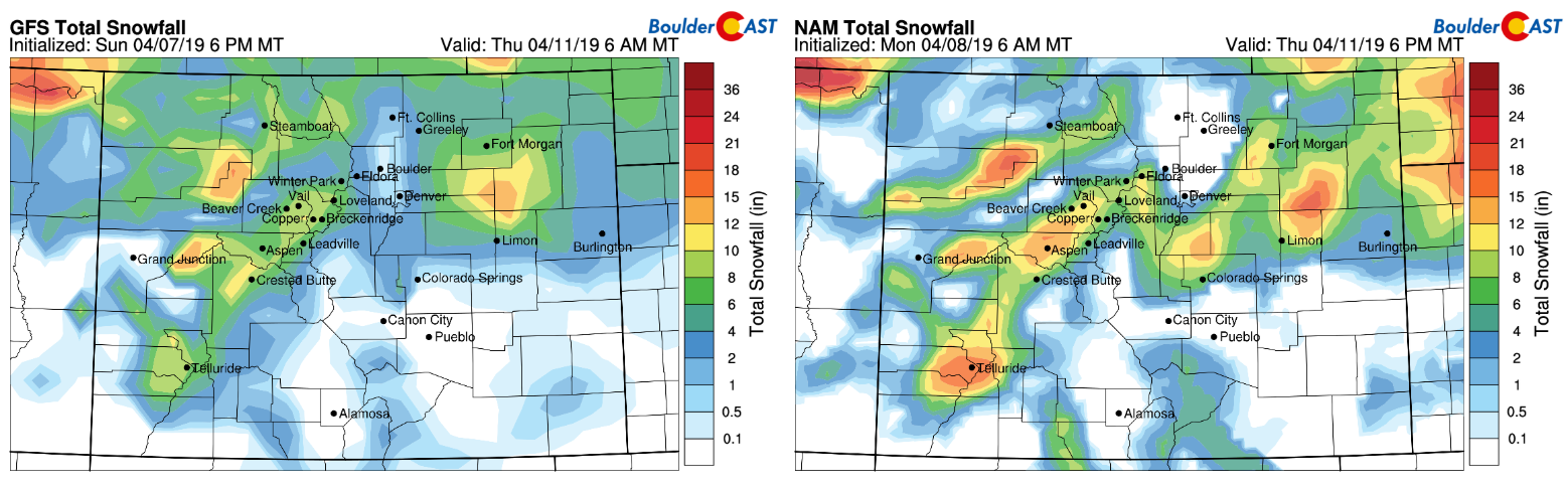
Model snowfall forecast from the GFS (left) and NAM (right) through Thursday
In the wake of the exiting storm system, northerly flow will linger across Colorado with temperatures remaining well below normal. Highs on Thursday may struggle to get out of the 30’s with clouds holding and possibly some light snow flurries as well. Friday will be a tad warmer with another chance of afternoon and evening rain/snow showers and highs in the 40’s. Beyond this, another storm system may be gearing up for Friday night and Saturday, with an emphasis on southern Colorado. At the minimum, it looks like temperatures will remain cooler than normal into the weekend for the Metro area.
More than likely this won’t be the last time you hear from us this week. Enjoy summer while it lasts…
Forecast Specifics:
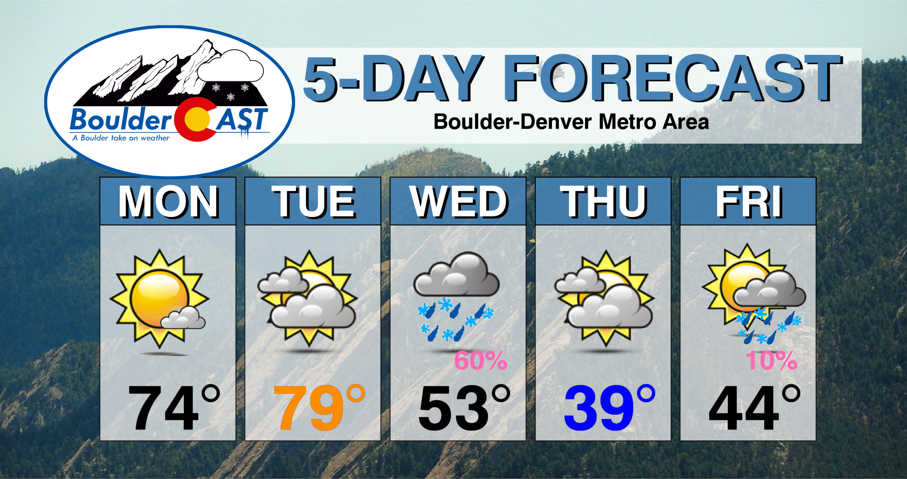
Monday: Mostly sunny and warm. Highs on the Plains in the middle 70’s and in the lower 60’s in the Foothills.
Tuesday: Near record warm temperatures with high clouds filling the sky throughout the day. Highs near 80 on the Plains and upper 60’s in the Foothills.
Wednesday: Colder air will filter in throughout the day from the north with precipitation chances increasing late morning through the rest of the day. Scattered rain showers changing to snow through the afternoon and into the evening. Light accumulations are possible. Winds gusting up to 35 mph during the afternoon and evening near Boulder, with up to 50 mph near and east of DIA. Morning highs in the 50’s across the Plains and in the 40’s in the Foothills, with temperatures falling into the low to middle 30’s through the day.
Thursday: Mostly cloudy and cool with a slight chance of lingering flurries, especially in the morning. Highs near 40 for the Plains and in the middle 20’s in the Foothills.
Friday: A mix of clouds and sun with a slight chance of afternoon/evening rain or snow showers. A bit warmer with highs on the Plains in the middle 40’s with lower 30’s in the Foothills.
High Country: Dry weather is expected Monday and Tuesday alongside very warm temperatures. Snow increases statewide Tuesday night and continues into Thursday night with 5 to 15″ possible for many ski resorts. Another, more southern-track storm is indicated Friday into Saturday which could produce 6+” for some resorts again, especially across southern Colorado. Check PowderCAST for updated forecasts for all the Colorado ski resorts.
DISCLAIMER: This weekly outlook forecast was created Monday morning and covers the entire upcoming week. Accuracy will decrease as the week progresses as this post is NOT updated. To receive daily updated forecasts from our team, subscribe to BoulderCAST Premium.

.
Share our forecast!


You must be logged in to post a comment.