In this final week of summer, Front Range Colorado will experience a mix of weather conditions. We’re tracking two main chances for rain in the extended: a quick shot of severe thunderstorms Tuesday afternoon and then widespread upslope showers by Friday or Saturday as autumn weather arrives right on schedule. The week will stay warm with temperatures in the 80s, but cooler, unsettled weather is looming for the weekend. Read on for the latest details.
This week’s highlights include:
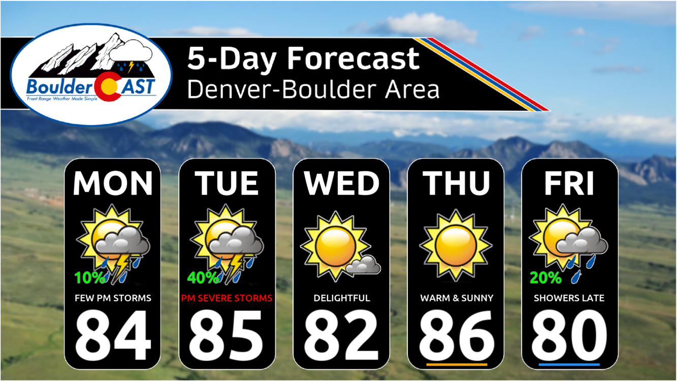
- Two Main Changes for Rain: The first a quick shot of thunderstorms Tuesday afternoon. The second chance arrives sometime Friday or Saturday in the form of widespread upslope rain showers.
- Gusty Tuesday with Severe Storms Possible: Gusty winds Tuesday ahead of a front will reach up to 30 MPH. Thunderstorms during the afternoon may produce severe wind gusts up to 60 MPH, mainly east of Denver.
- A Mostly Warm Week: Temperatures will land above normal much of the week ahead in the 80s, but should drop down below normal by Friday or Saturday.
- Unsettled Weekend Weather? Most models indicate a strong fall-like storm will impact Colorado Friday into Saturday with widespread rainfall and cooler temperatures — the timing and exact impacts are still uncertain.
DISCLAIMER: This weekly outlook forecast is created Monday morning and covers the entire upcoming week. Accuracy will decrease as the week progresses as this post is NOT updated. To receive daily updated forecasts from our team, among many other perks, subscribe to BoulderCAST Premium.

Go Premium, get all the perks.
Daily Forecast Updates
Get our daily forecast discussion every morning delivered to your inbox.
All Our Model Data
Access to all our Colorado-centric high-resolution weather model graphics. Seriously — every one!
Ski & Hiking Forecasts
6-day forecasts for all the Colorado ski resorts, plus more than 120 hiking trails, including every 14er.
Smoke Forecasts
Wildfire smoke concentration predictions up to 72 hours into the future.
Exclusive Content
Weekend outlooks every Thursday, bonus storm updates, historical data and much more!
No Advertisements
Enjoy ad-free viewing on the entire site.
Watching two troughs to bring rain chances
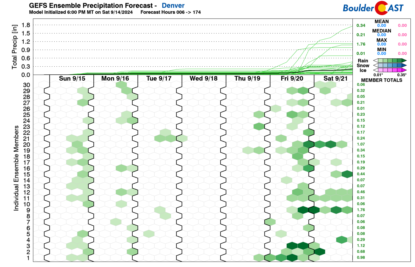
The GEFS ensemble plume rainfall forecast is shown below for the upcoming week. As one looks initially, there is not a strong signal for rain early in the week. Just a few ensemble members are indicating storms Monday and Tuesday. The better chance for us is late Friday into Saturday. While that appears to be the better signal, we will also have a chance early in the week as well, as we’ll see later.
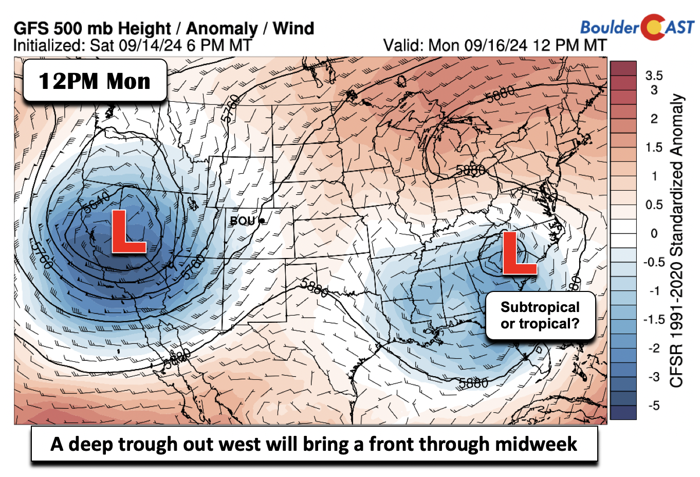
The week kicks off with a big, deep closed low pressure over California and Nevada. Southwest flow will be in full-swing at mid-levels across the Centennial State which will spell out a continuation of our above normal temperatures with highs pushing into the middle 80s on Monday. While a chance of storms will exist, it will be quite low, just 10 to 20%, as a surface lee trough promotes downslope flow and inhibits storms from encroaching into the Plains from the higher terrain. Any storms that move in Monday afternoon could produce light to moderate rainfall and wind gusts up to 40 MPH.
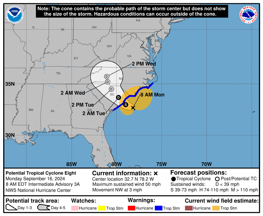
Outside of our neck of the woods, a disturbance will move inland across the Carolinas today into Tuesday. It’s currently being called Potential Tropical Cyclone Eight, but it is expected to develop into a weak Tropical Storm (Helene) before landfall. Nevertheless it will bring gusty winds, heavy rainfall and flooding, as well as a non-zero tornado threat to the Carolina coast on Monday.
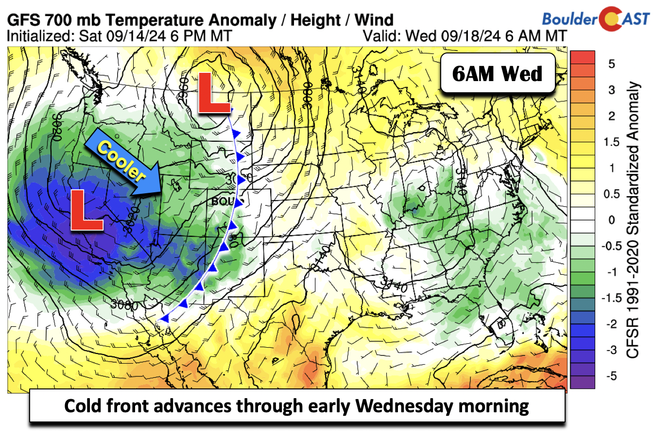
On Tuesday, we should see the main impacts from the aforementioned trough to our west. A cold front will advance eastward into eastern Utah and central Wyoming. Ahead of the front, which will not move through until early Wednesday, gusty west-southwest winds will develop. This combined with warm temperatures in the mid to upper 80s and dry air, will breed minor fire concerns during the day into early evening, though Red Flag Warnings are not likely due to the brevity of things.
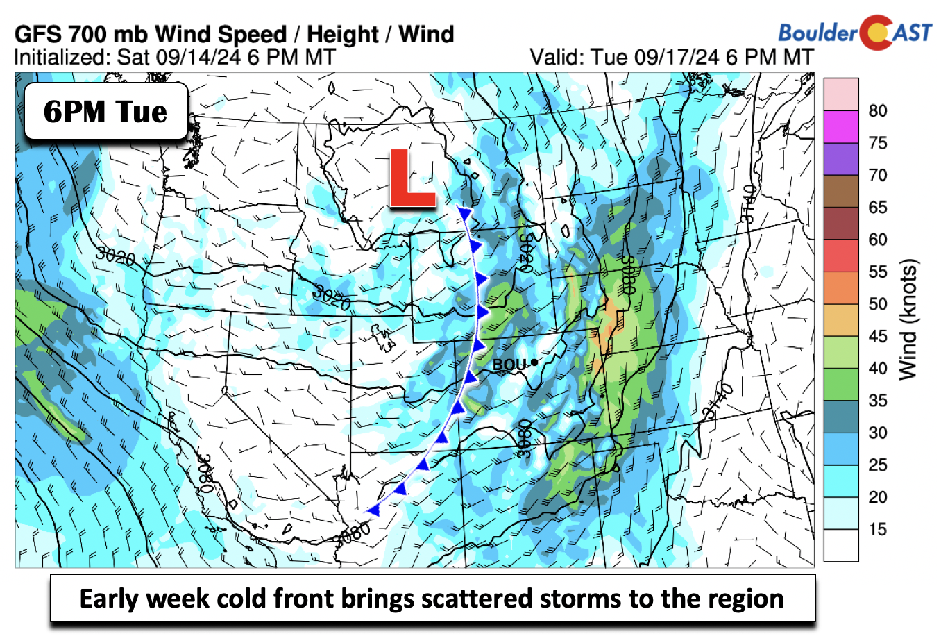
As a strong surface low tracks into eastern Montana, the trailing cold front will bring an increased chance of storms (30-40%) Tuesday afternoon and evening to northern Colorado. Short-range model guidance, such as the HRRR shown below, are all mostly indicating a fairly solid line of thunderstorms racing across the Denver Metro area Tuesday afternoon, exiting into Nebraska and Kansas during the evening.
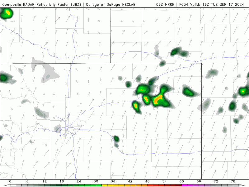
HRRR model-simulated radar animation for Tuesday showing a line of storms moving through the area from the southwest
Given the raw speed of the storms being pushed along by fast southwest winds aloft, we are concerned about damaging wind gusts Tuesday afternoon (Denver area) and afternoon/evening (Eastern Plains). Gusts up to 60 MPH may accompany some of the line, with the Storm Prediction Center currently including our area at Marginal Risk. You may want to pre-emptively prepare for the strong winds, especially if you live northeast of Denver.
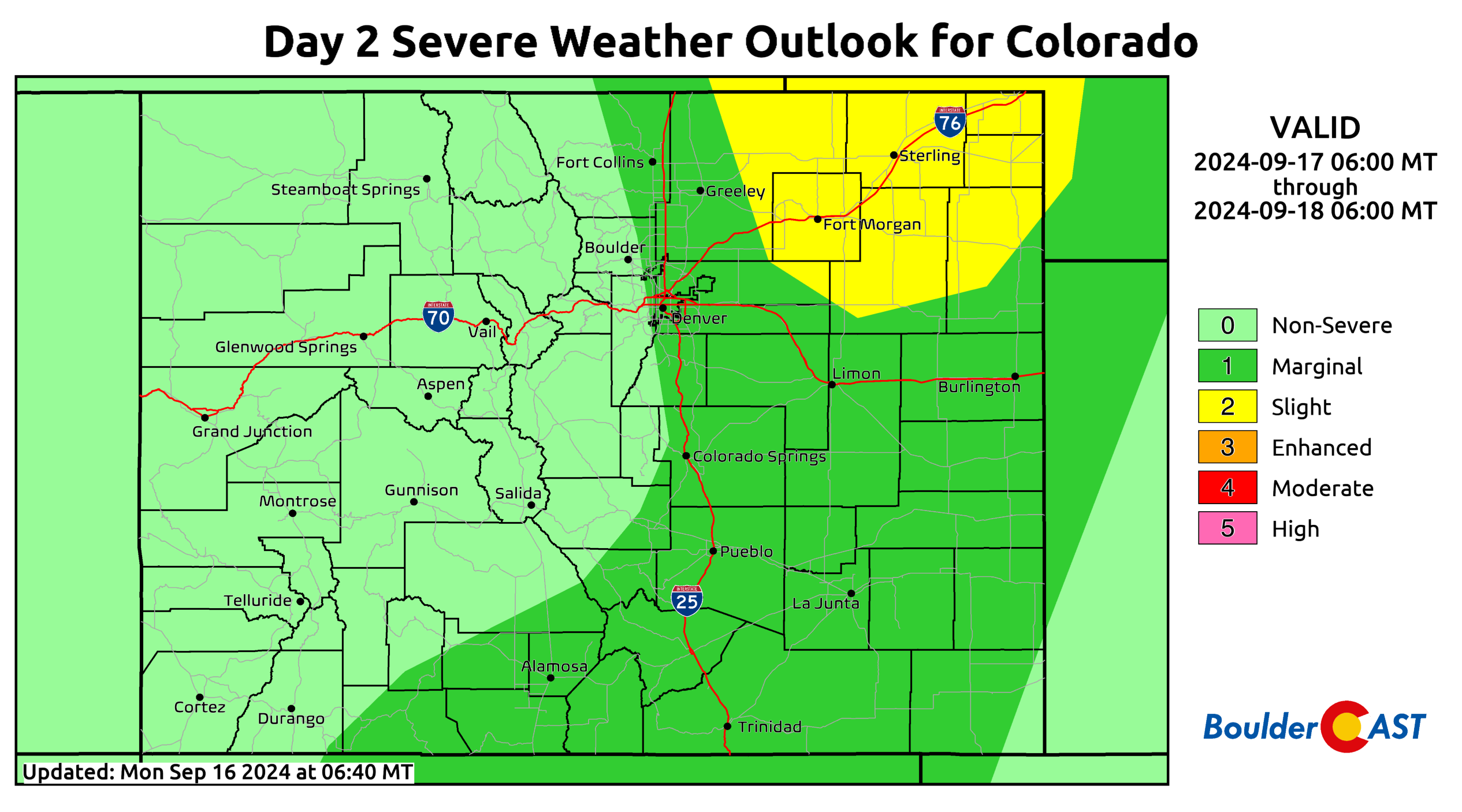
Severe weather outlook for Tuesday from the SPC
Come Wednesday in the Front Range, we should see a lull in active weather. Highs are expected to be a bit cooler but still above normal in the lower 80s. Waiting in the wings is a deeper trough over west-central California which will impact us later this week.
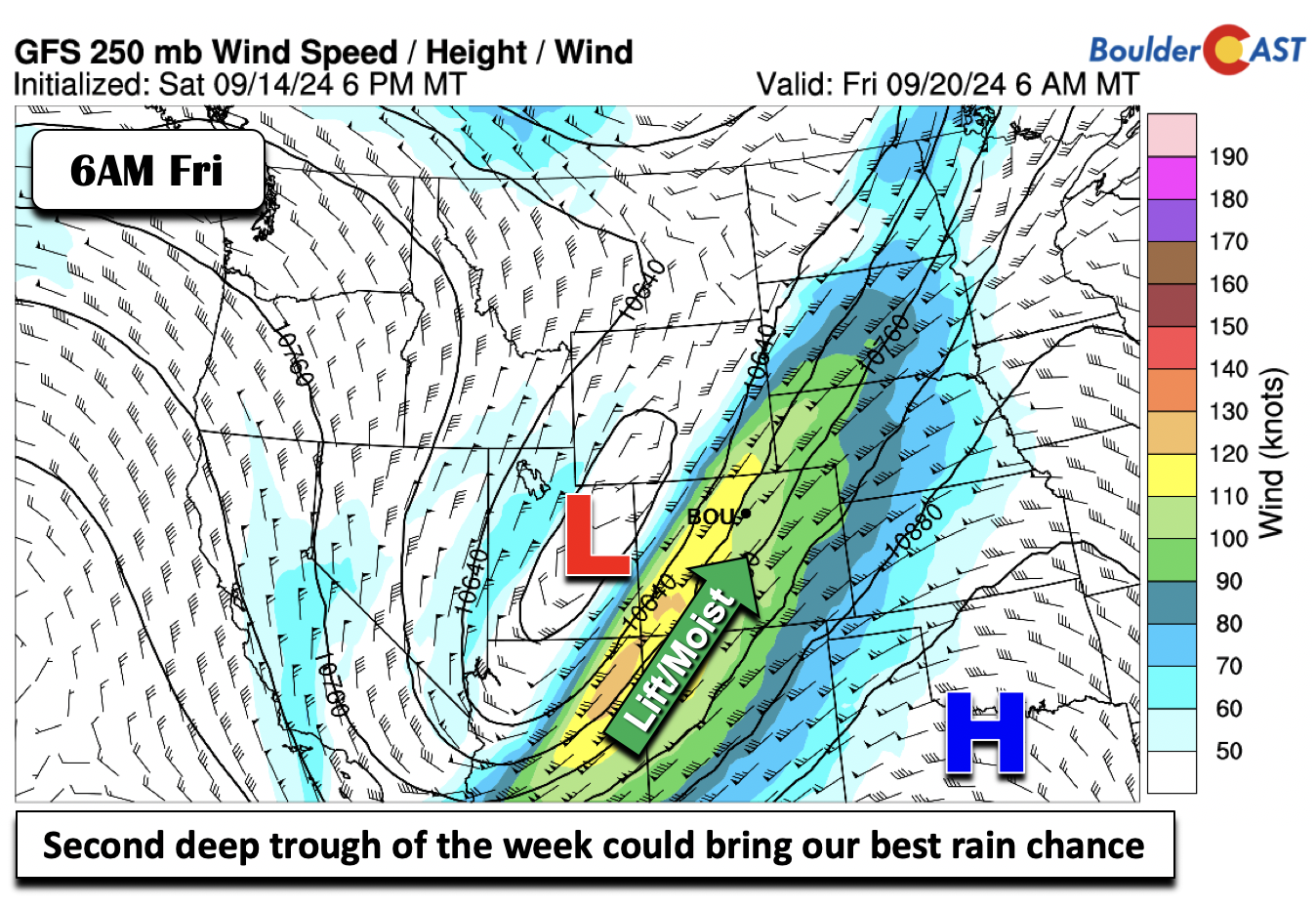
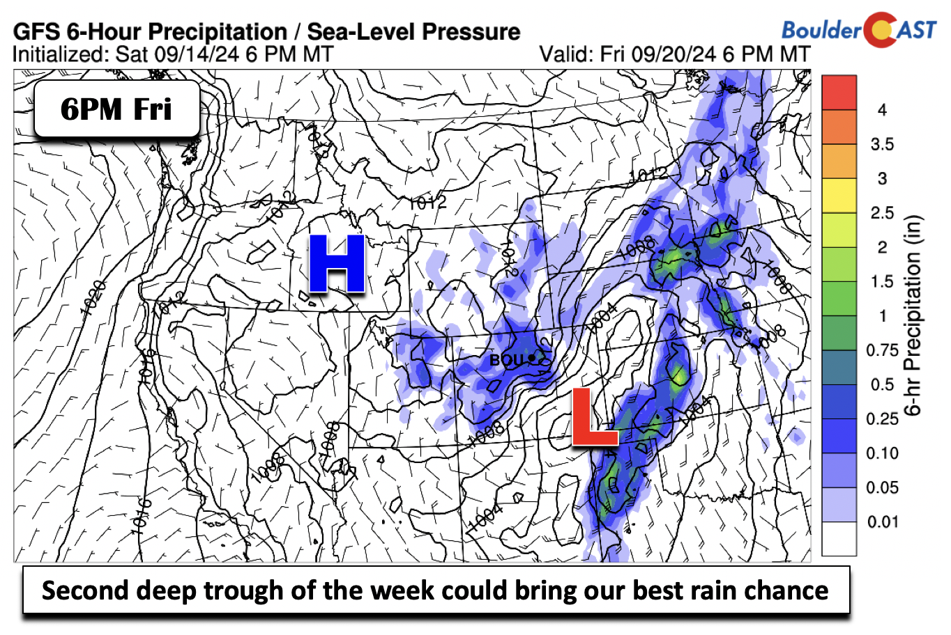
The second trough of the week is poised to influence us sometime Friday into Saturday. The guidance is mixed on timing, with the fasting arrival being Friday afternoon, and the slowest being Saturday into Saturday night. Either way you slice it, it will be an active end to the week for us. Deep lift and moisture will overspread the region. We should see a quiet Thursday for the most part as highs should stay in the low to middle 80s.
By Friday, there are some models showing that another front will move south into the Denver Metro area and favor cooler high temperatures (70s), but that is far from certain at this juncture. The more common solution would be for a slower arrival with Friday staying warm in the 80s again.
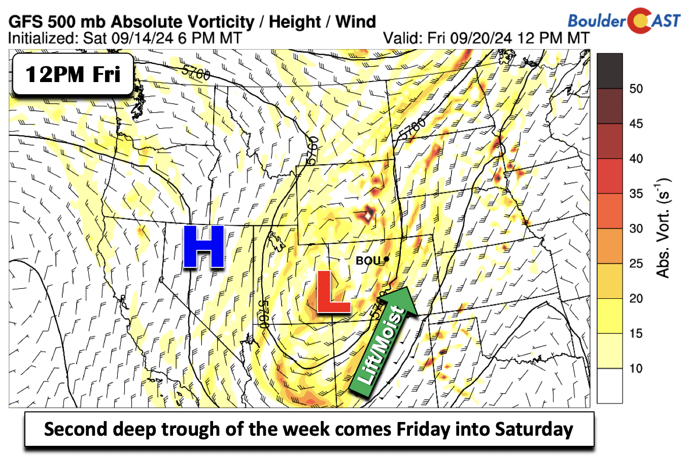
Regardless of timing, the ensemble data shows our best shot of rain will be late this week into the the weekend. A surface low may form over southeast Colorado and favor upslope showers and unsettled weather — it’s been quite a while since we’ve seen a true upslope storm here in the Front Range so this is interesting. If that solution does occur, we could see a much cooler start to the weekend in the lower 60s or even some — *gasp* — 50s!
Stay tuned for updates and enjoy the nice weather this week ahead of a cooler and more active weekend ahead!
The Flatirons hit different when returning home after a long trip. Every time. #Boulder #cowx 🥰 pic.twitter.com/wWvwx6gCsT
— BoulderCAST Weather 🏔️❄️ (@BoulderCAST) September 15, 2024
Forecast Specifics:
Monday: Morning sun becoming mostly cloudy with a 10% chance of afternoon widely isolated storms. Highs in the middle 80s for the Plains and middle 70s in the Foothills.
Tuesday: Sunny skies becoming mostly cloudy with a 30-40% chance of afternoon and evening storms. Gusty winds of up to 35 MPH on the Plains will raise fire danger as highs reach the mid to upper 80s and mid to upper 70s in the Foothills.
Wednesday: Mostly sunny and quiet with temperatures closer to average but still warm in the low to mid 80s on the Plains and lower 70s in the Foothills.
Thursday: Mostly sunny and warm. Highs in the middle 80s for the Plains and mid 70s over the Foothills.
Friday: Increasing clouds with a chance of late-day rain showers — though this is uncertain. The chance appears better late in the day into Saturday. High temperatures on Friday could be as cool as the lower 70s or as high as the upper 80s on the Plains. Highs over the Foothills in the upper 60s to near 70. Check back for updates on this weekend rainy system.
Get BoulderCAST updates delivered to your inbox:
DISCLAIMER: This weekly outlook forecast is created Monday morning and covers the entire upcoming week. Accuracy will decrease as the week progresses as this post is NOT updated. To receive daily updated forecasts from our team, among many other perks, subscribe to BoulderCAST Premium.
Go Premium, get all the perks.
Daily Forecast Updates
Get our daily forecast discussion every morning delivered to your inbox.
All Our Model Data
Access to all our Colorado-centric high-resolution weather model graphics. Seriously — every one!
Ski & Hiking Forecasts
6-day forecasts for all the Colorado ski resorts, plus more than 120 hiking trails, including every 14er.
Smoke Forecasts
Wildfire smoke concentration predictions up to 72 hours into the future.
Exclusive Content
Weekend outlooks every Thursday, bonus storm updates, historical data and much more!
No Advertisements
Enjoy ad-free viewing on the entire site.
Enjoy our content? Give it a share!


You must be logged in to post a comment.