The dog-days of summer are squarely behind us as cool and unsettled weather continue across the Front Range this week. Though things will dry out briefly Monday and Tuesday, soggy conditions quickly return as a Pacific trough slowly rakes across the region later in the week. Up to 1″ of rainfall is projected by week’s end along with some of the coldest temperatures we’ve seen in many moons. Let’s take a look!
This week’s highlights include:
- After widespread rainfall Sunday night (and Mountain snow!), a drying trend ensues early in the week
- Monday and Tuesday will be fairly pleasant with sunshine mixed in and little to no rainfall chances
- A slow-moving system is set to arrive later in the week keeping things cool and unsettled
- The best chance of rain comes Thursday, but decent chances also exist Wednesday and Friday
- Temperatures stay below normal every single day this week, culminating on Friday when we may struggle to reach 60°

DISCLAIMER: This weekly outlook forecast is created Monday morning and covers the entire upcoming week. Accuracy will decrease as the week progresses as this post is NOT updated. To receive daily updated forecasts from our team, among many other perks, subscribe to BoulderCAST Premium.

Go Premium, get all the perks.
Daily Forecast Updates
Get our daily forecast discussion every morning delivered to your inbox.
All Our Model Data
Access to all our Colorado-centric high-resolution weather model graphics. Seriously — every one!
Ski & Hiking Forecasts
6-day forecasts for all the Colorado ski resorts, plus more than 120 hiking trails, including every 14er.
Smoke Forecasts
Wildfire smoke concentration predictions up to 72 hours into the future.
Exclusive Content
Weekend outlooks every Thursday, bonus storm updates, historical data and much more!
No Advertisements
Enjoy ad-free viewing on the entire site.
Drying out rapidly early in the week
The seemingly endless dog days of summer which we had endured at the beginning of September are now behind us with cooler weather in store for the week ahead. This pattern shift commenced with a cold front moving through this past Saturday evening. Since then, shallow upslope flow has been situated across eastern Colorado leading to low clouds, mist, cooler temperatures, poor air quality, and at times, actual raindrops falling from the sky — a welcomed changed indeed!
Following an overnight cold front, low clouds and Canadian smoke hang over #Boulder. Also seeing some occasional mist! 🌫️ #cowx pic.twitter.com/tqUSAk5MFG
— BoulderCAST Weather (@BoulderCAST) September 10, 2023
Overnight rainfall totals ending Monday morning landed between 0.25 and 1.00″ in the Boulder-Denver Metro area, with the highest totals coming from around Longmont, Lyons and Niwot which got hit by a weak thunderstorm Sunday evening.
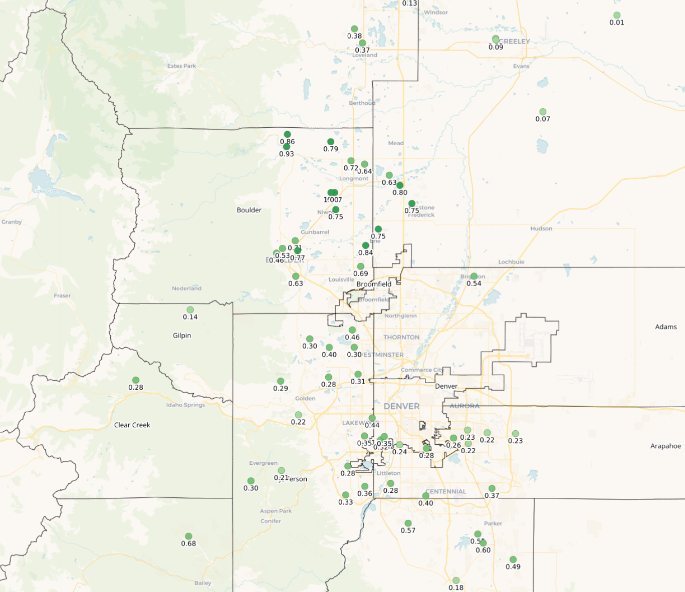
24-hour rainfall totals ending ~7AM MT Monday 9/11/23
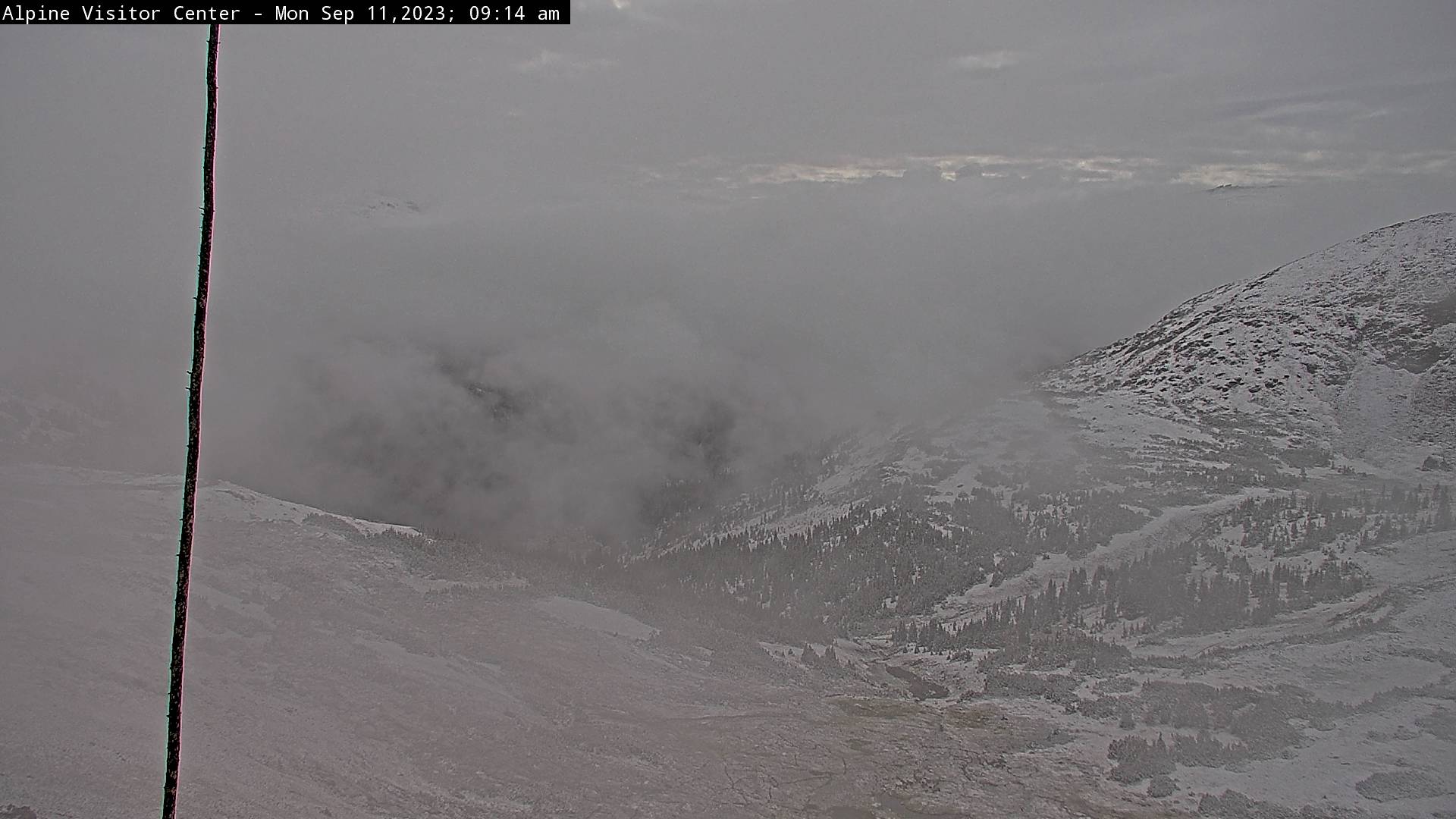
The highest elevations saw light accumulating snow overnight, the first blanket of white since early June! Here’s the view from Rocky Mountain National Park this morning (near 12,000 feet):
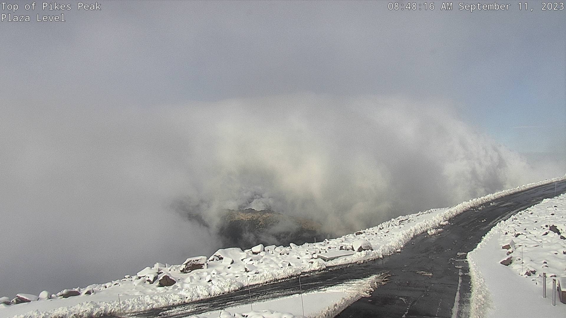
Similarly, the view is also wintry from the top of 14,200-foot Pikes Peak which received a more significant accumulation from this departing storm:
As of early Monday morning, a bulk of the wet weather has shifted south and east of the Denver Metro area. Widespread light to moderate rainfall lingers across the southeastern part of the state while drier air is filtering in from the northwest rather quickly — something that will contribute to a rapid drying trend for us early in the week.
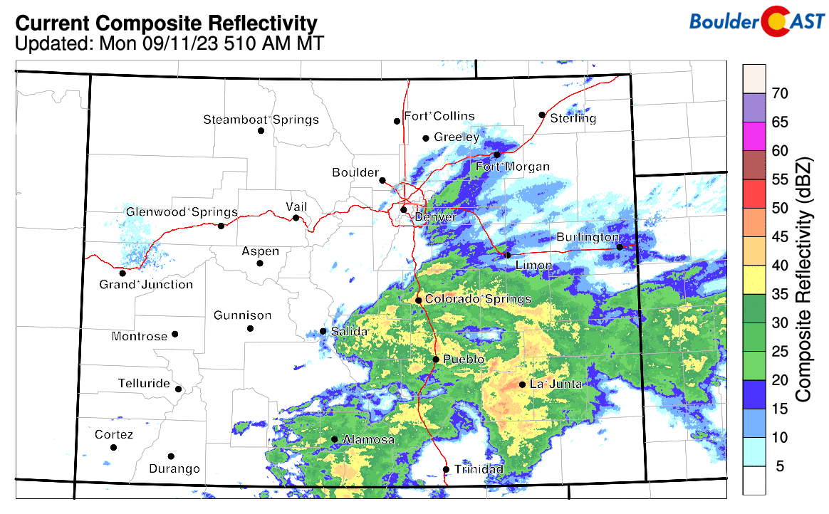
The pattern on Monday across the West is a complex one with numerous shortwave disturbances and even a weak ridge embedded in the west-northwesterly flow (see below). The system which brought rain Sunday night is departing to the southeast with a ridge now moving in from the northwest. With clouds remaining for a chunk of the day Monday and a stable atmosphere, the arrival of the ridge will only help to further keep things in-check over the Front Range. A secondary weak shortwave will come ashore into northern California Monday reaching Colorado by Tuesday. Current model trends take this small-scale system south of our area with more rain in the cards for areas south of Denver, but little to no precipitation expected in our immediate area.

The best chance of rain on Monday actually comes in the pre-dawn hours (but those showers are already vacating the area as of writing) with just a slight chance of some popcorn showers redeveloping in the afternoon and early evening. Additional showers that spawn late in the day Monday should remain confined to the Foothills where some instability exists, mainly southwest of Denver. Highs on Monday will be well below seasonal normals in the middle 60s — we should be near 80° this time of year!

The weak system passing to our south on Tuesday could spawn a few isolated showers or storms along and south of the Palmer Divide. For the most part, Tuesday will be a pleasant day in the Boulder-Denver area with temperatures returning into the middle 70s. In fact, as you will soon see, Tuesday will be the nicest day of the week!
Wet weather returns mid to late week
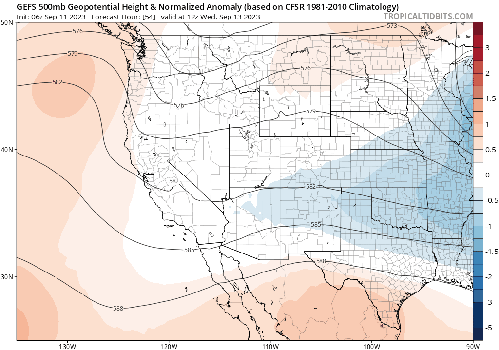
As we move into the middle to latter part of the week, a slow-moving broad trough of low pressure digs in across the central and northern Rockies. It’s not a significant trough by any means, but it will keep things cool and unsettled across the Front Range beginning Wednesday and continuing through Thursday and likely Friday as well. The European ensemble 500mb height anomaly forecast for Wednesday through Friday is shown below. Behind our weak trough a more substantial ridge develops across the Pacific Northwest — something that will be a player for us over the upcoming weekend.
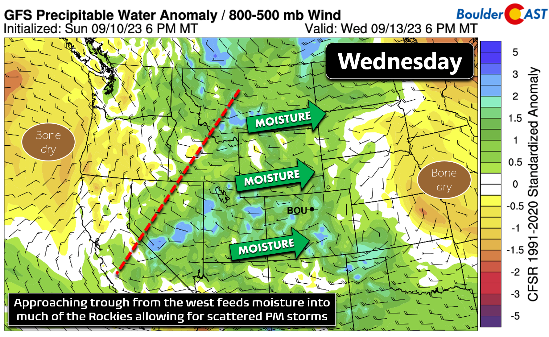
Though still several days away, models are coming into better agreement with how this late-week system will evolve, mostly keeping it as an open wave across the region. Prior model runs were showing a potential cut-off low pressure which could have had soggier impacts. That looks increasingly unlikely now. Still, we are expecting a notable uptick in rainfall chances beginning Wednesday in the form of scattered late-day thunderstorms as Pacific moisture increases from the west ahead of the trough.
Thursday into Friday the slow-moving trough will be positioned directly over Colorado making these the most unsettled days of the week. The GFS in particular, as shown below, stalls and elongates the trough almost due west-to-east across the Front Range on Friday. The Euro moves things through a little faster but both models have cool and showery weather for us both days.

Nonetheless, it looks like Thursday will have the best chance of rain this week with scattered to widespread late-day thundershowers expected with temperatures falling back to near 70 degrees for highs. Friday will also have a pretty decent chance of showers while also ending up as the coldest day of the week. Both the GFS and Euro models are in good agreement for highs struggling to reach 60°F on Friday as a secondary cold front arrives ahead of deep northerly flow.

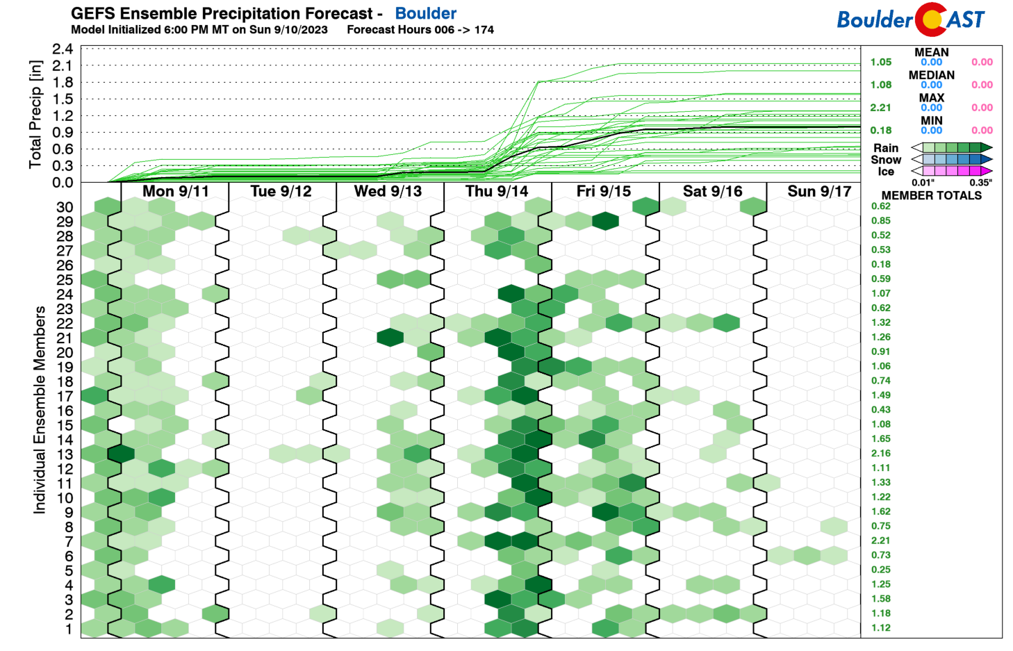
The GFS ensemble mean rainfall is around 0.75″ in Boulder for the back half of the week (Wednesday to Saturday), with the focus clearly on late-day Thursday for the most intense precipitation and best overall chances of wet weather.
Plan on Tuesday being the nicest day of the week, though Monday won’t really be that bad either. After a brief midweek warm-up, things turn ugly once again. Yes, the late-week period will be cold and soggy, something that is typical for us this time of year. Fortunately, unlike the record-shattering September 2020 storm, it won’t be cold enough for snow just yet! Enjoy the weather!
The Great Colorado Flood: 10 Years Ago This Week
Ten years ago this week, torrential rains fell across the Front Range, triggering one of the worst floods in Colorado’s short recorded history, accompanied by a staggering repair bill of over $3 billion. Boulder County was at the epicenter of the disaster receiving more than a year’s worth of rainfall in just one week. The road to recovery has been long and arduous, and surprisingly still continues today. We take a look back at this historic flood event, explain how it happened, and provide an update on related analysis performed since. Read the full post here.

Forecast Specifics:
Monday: A slight chance of rain showers in the morning with low clouds clearing to reveal some sunshine by afternoon. Isolated thundershowers may reform in the late-day period, mainly across the higher terrain southwest of Denver. Most of us stay completely dry after the morning gloom clears. Highs reach the middle 60s on the Plains with middle 50s in the Foothills.
Tuesday: Partly to mostly sunny in what will be the most pleasant day of the week. One or two storms may form south of Denver along the Palmer Divide. Temperatures remain cool in the middle 70s for highs on the Plains with lower 60s in the Foothills.
Wednesday: Some sun early, then increasing clouds with scattered late-day thunderstorms. Highs in the middle to upper 70s across the Plains with middle 60s in the Foothills.
Thursday: Cooler with numerous to widespread showers and a few thunderstorms expected. Highs top out around 70 degrees on the Plains with upper 50s in the Foothills.
Friday: Staying gloomy with scattered rain showers and temperatures very chilly topping out only in the lower 60s at best. Some places may stay in the 50s. Highs in the Foothills will be in the lower 50s.
DISCLAIMER: This weekly outlook forecast is created Monday morning and covers the entire upcoming week. Accuracy will decrease as the week progresses as this post is NOT updated. To receive daily updated forecasts from our team, among many other perks, subscribe to BoulderCAST Premium.
Go Premium, get all the perks.
Daily Forecast Updates
Get our daily forecast discussion every morning delivered to your inbox.
All Our Model Data
Access to all our Colorado-centric high-resolution weather model graphics. Seriously — every one!
Ski & Hiking Forecasts
6-day forecasts for all the Colorado ski resorts, plus more than 120 hiking trails, including every 14er.
Smoke Forecasts
Wildfire smoke concentration predictions up to 72 hours into the future.
Exclusive Content
Weekend outlooks every Thursday, bonus storm updates, historical data and much more!
No Advertisements
Enjoy ad-free viewing on the entire site.
Get BoulderCAST updates delivered to your inbox:
Enjoy our content? Give it a share!


You must be logged in to post a comment.