Bundle up and brace for an eventful week of fall weather across the Front Range as temperatures turn colder! Gusty winds and even a few thundershowers on Monday will precede a frontal boundary set to bring the season’s coldest air yet. Read on for all the details of the week ahead, including a discussion of nightly hard freezes, the Halloween forecast, and a weekend warm-up that might just make you forget it’s the start of November…
This week’s highlights include:
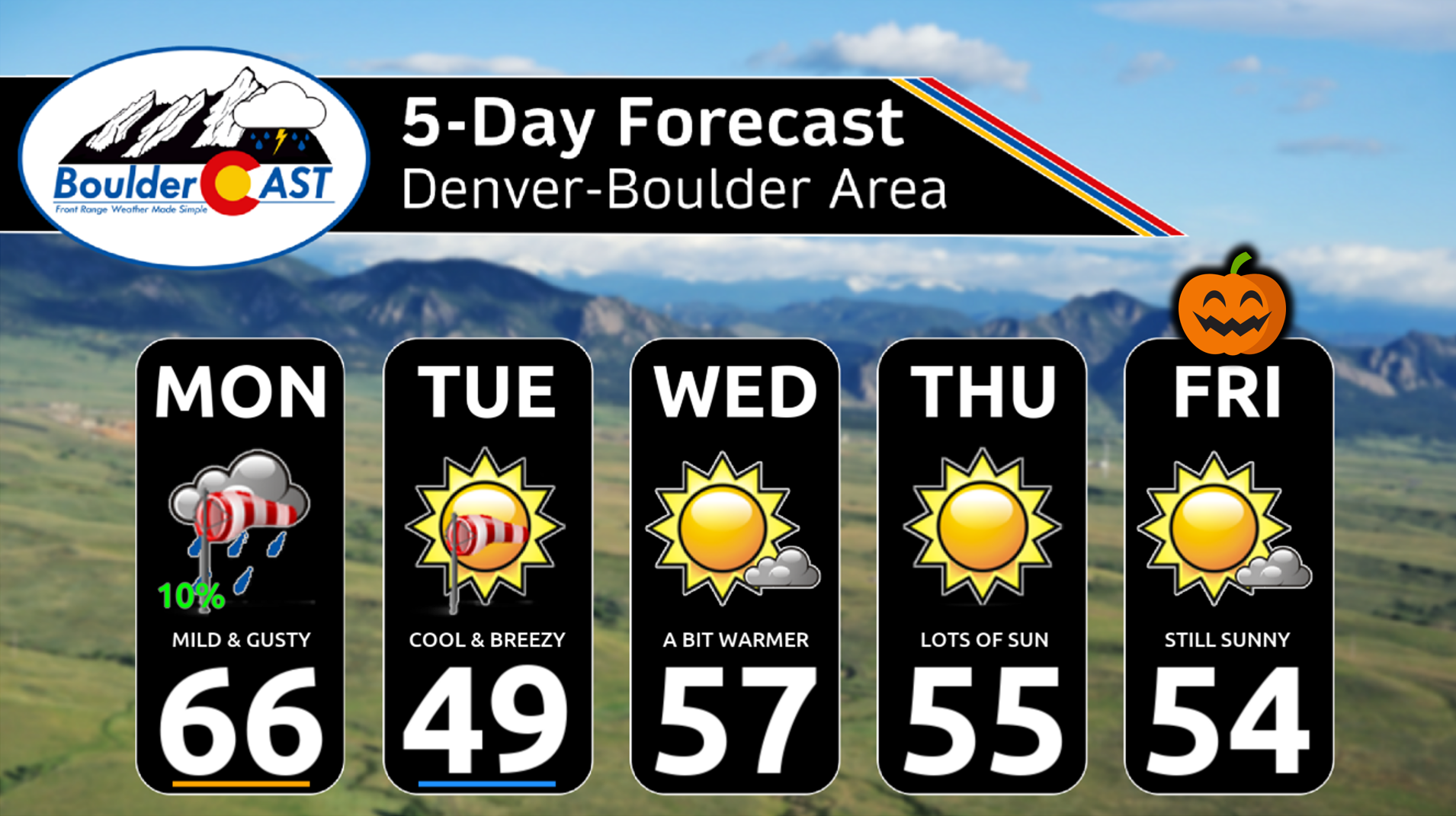
- 🌬️ Windy Monday: Breezy conditions kick in mid-morning with gusts up to 40 MPH on the Plains and 50+ MPH in the Foothills. Mind the crosswinds if you’re driving north-south!
- 🌡️ Mild Before the Plunge: Monday hits the mid-60s—our warmest day of the week—before a sharp cold front drops temps into the upper 20s by Tuesday morning.
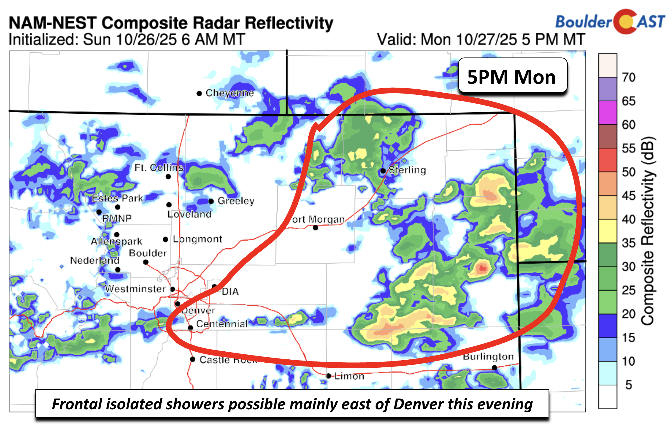
- 🌧️ Evening Showers & Thunder: Scattered light showers possible 4–8 PM Monday, mainly east of I-25. A few thunderstorms may pop closer to Nebraska/Kansas.
- 🥶 Coldest Air Yet: Tuesday highs only in the 40s with winds making it feel even colder. A hard freeze expected nightly with lows in the 20s, coldest Wednesday morning in the lower 20s.
- 🎃 Halloween = Chilly but Calm: Friday stays dry with highs in the 50s and evening trick-or-treat temps dipping into the 40s or upper 30s.
- ☀️ Weekend Rebound: A ridge builds in, bringing sunshine and highs in the 60s to low 70s Saturday and Sunday—gorgeous fall weather!
DISCLAIMER: This weekly outlook forecast is created Monday morning and covers the entire upcoming week. Accuracy will decrease as the week progresses as this post is NOT updated. To receive daily updated forecasts from our team, among many other perks, subscribe to BoulderCAST Premium.

Go Premium, get all the perks.
Daily Forecast Updates
Get our daily forecast discussion every morning delivered to your inbox.
All Our Model Data
Access to all our Colorado-centric high-resolution weather model graphics. Seriously — every one!
Ski & Hiking Forecasts
6-day forecasts for all the Colorado ski resorts, plus more than 120 hiking trails, including every 14er.
Smoke Forecasts
Wildfire smoke concentration predictions up to 72 hours into the future.
Exclusive Content
Weekend outlooks every Thursday, bonus storm updates, historical data and much more!
No Advertisements
Enjoy ad-free viewing on the entire site.
A Lively Monday: Warm & gusty turning colder behind a front
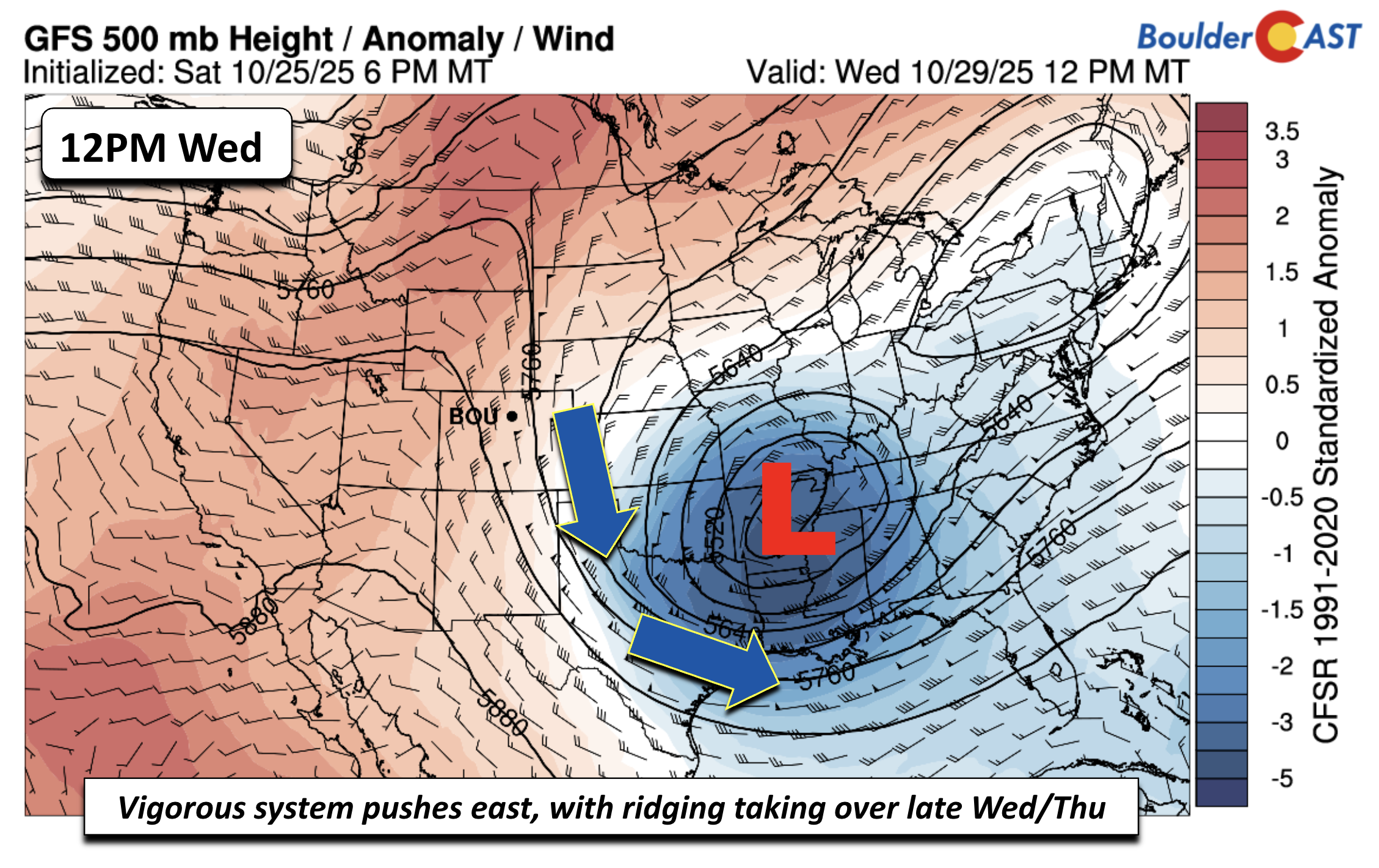
We’re kicking off the week with a dynamic weather setup, thanks to a robust upper-level trough spinning over eastern Montana and the northern Plains. This system is set to stir up breezy conditions, light snow in the High Country, and even a few stray thundershowers across the eastern Plains. And yes—get ready for cold weather. This system is packing the coldest air we’ve seen so far this fall.
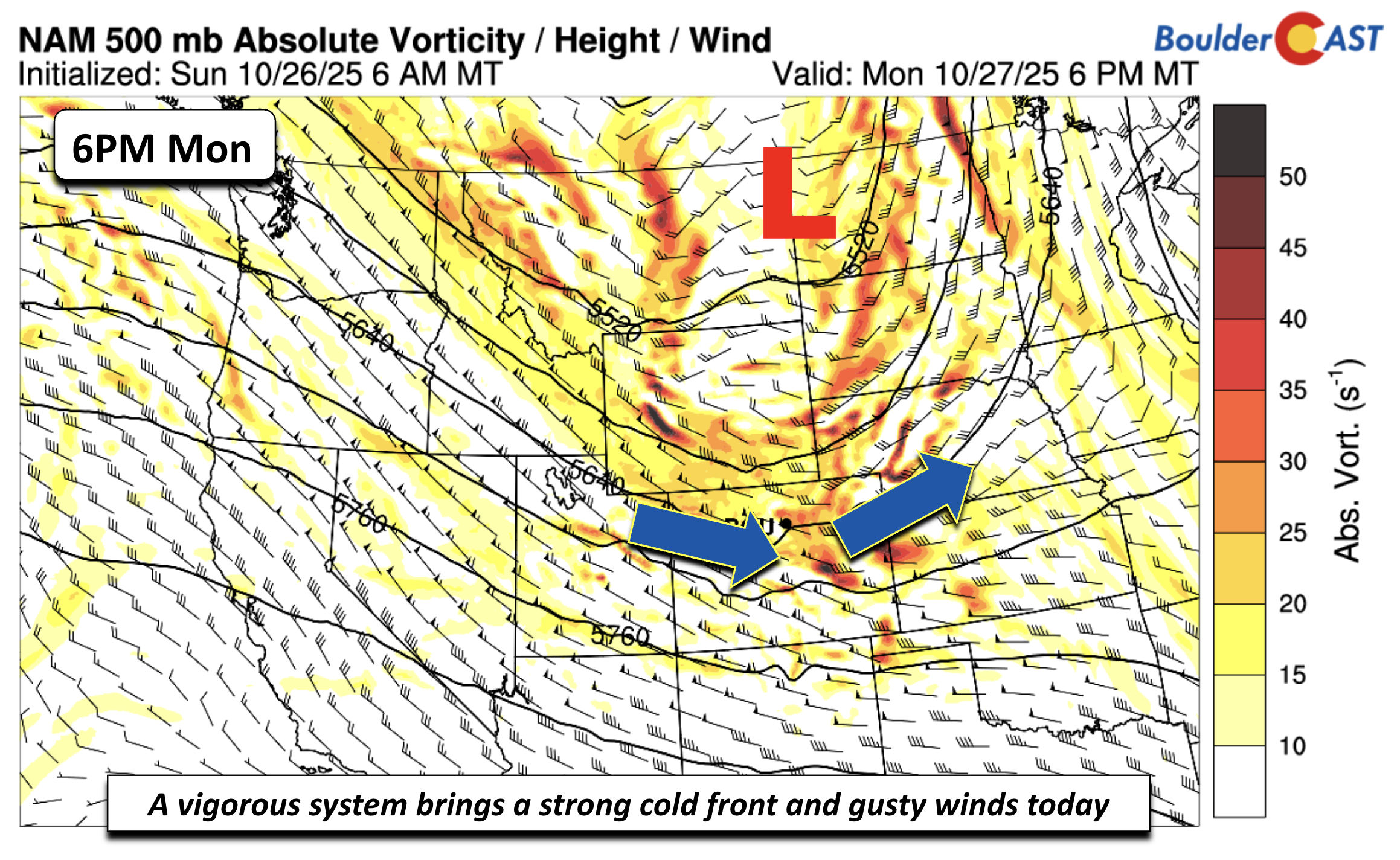
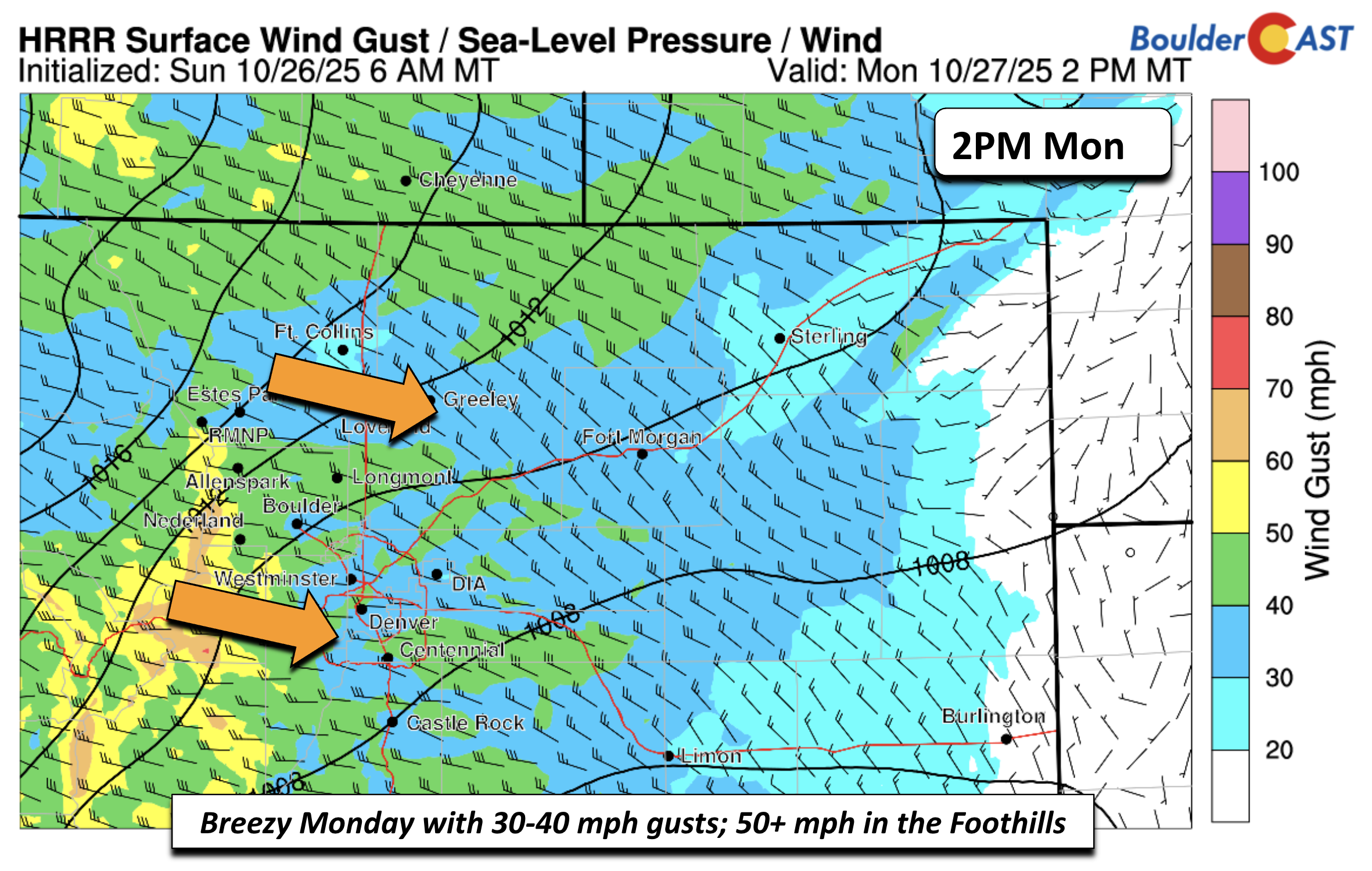
Coupled to the trough will be a strong jet streak directed west-east over the state. This is going to fuel breezy conditions for both the Mountains, Foothills, and Plains alike on Monday. Expect gusts to ramp up by mid-morning Monday and peak in the afternoon. Winds could hit 40 MPH across the Plains (most spots will see 25–35 MPH), while the Foothills could see gusts topping 50 MPH. If you’re driving north-south, especially on exposed stretches, be mindful of crosswinds.
Temperatures will briefly flirt with the mid-60s Monday afternoon—our only above-average day this week.
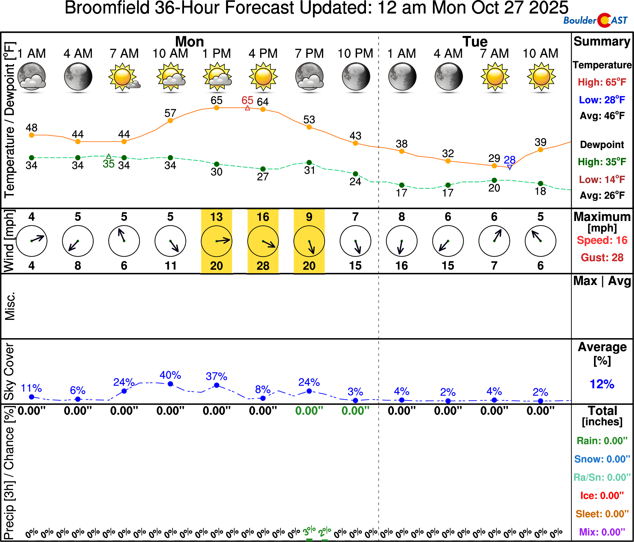
A sharp cold front will barrel through the Boulder–Denver area early Monday evening. Temps will tumble into the 40s by late evening and bottom out in the upper 20s by Tuesday morning. Between 4–8 PM, expect scattered light showers, mainly east of I-25 where downslope suppression will be less of a factor. Some embedded thunder is possible closer to the Nebraska/Kansas border, where instability will be higher.
Post-front, Tuesday will be brisk. Highs will struggle to climb out of the mid to upper 40s around the Denver Metro. Aloft, temps at 700mb (~5,000 ft) will be as cold as -12°C. Add in 25 MPH gusts and it’ll feel even chillier. Definitely a day for warm layers.

Hard freezes expected nightly through midweek
This cold airmass will linger, keeping temps below average through Wednesday. More importantly, we’re looking at several nights of hard freezes. Lows will dip into the upper 20s Tuesday morning and likely fall into the lower 20s by Wednesday (upper teens in outlying areas). If your garden somehow dodged the season’s first freeze last week, it won’t escape this one.

If your neighborhood is one of the last remaining parts of the Denver Metro area yet to see sub-freezing temperatures this autumn, that ends abruptly this week!
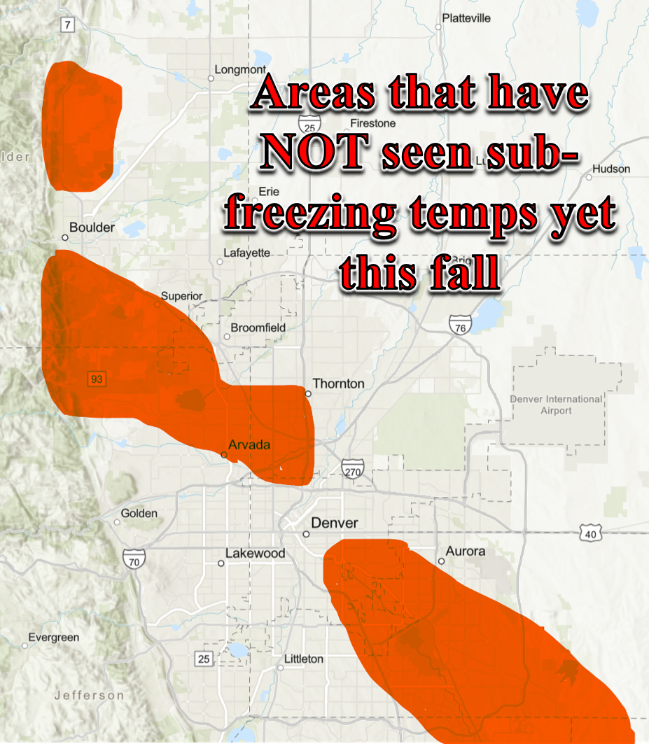
Approximate areas that have not seeing a widespread killing freeze yet as of Monday Oct 27 (red shading)
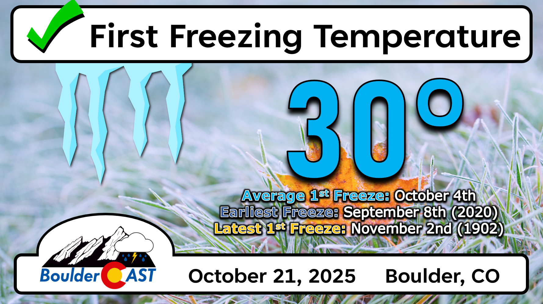
Boulder officially already had its first freeze of the season last Tuesday by the way…
Quiet but cool the rest of the week
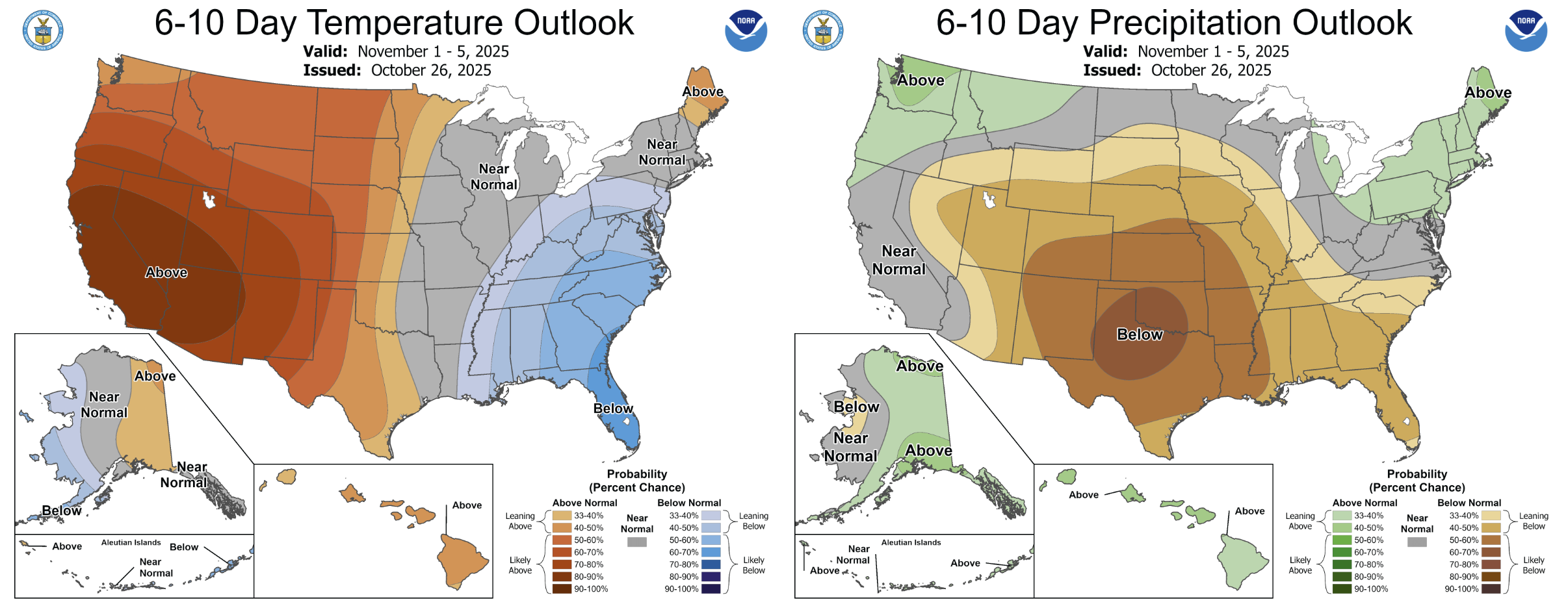
By Wednesday, the upper trough shifts east into the Mississippi Valley. Northerly flow will keep things cool, but a ridge begins to build late Wednesday into Thursday. That’ll quiet things down across the Front Range. Highs Wednesday and Thursday should rebound into the mid-50s — still below average, but a step in the right direction.
By late Thursday and Friday, model guidance is hinting that another cold front slides down in a return northwesterly flow pattern at mid-levels. This should favor near to below normal highs to close out the week in the mid to upper 50s, or low/mid 50s if the airmass verifies colder than currently anticipated.
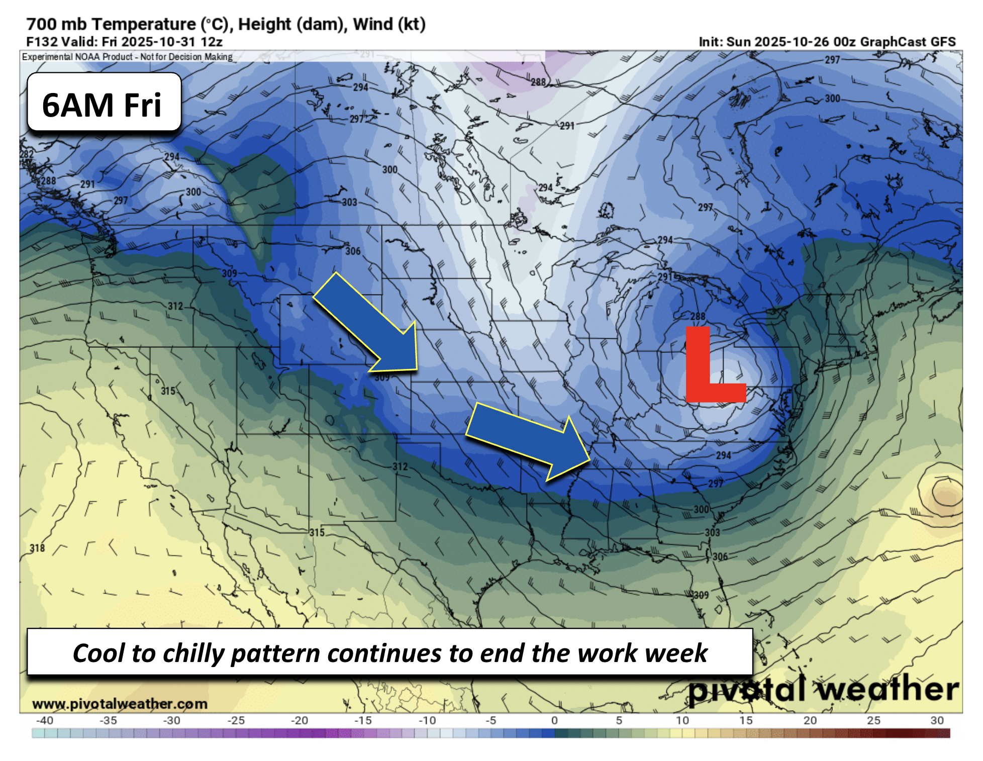
A few model solutions, including the Canadian, ECMWF, and GFS-AI models, suggest the the late-week cold front will contain a weak and fast-moving shortwave diving down out of Wyoming sometime Friday. Much of the guidance is completely dry. However, if the system were to trend stronger and more westward, it could favor a rain/snow chance over the area (mostly Mountains). Confidence in that verifying right now is pretty low, but it’s worth keeping an eye on it given the time of year.

Friday looks quiet overall, with highs in the 50s and temps dipping into the 40s by evening—cool but manageable for trick-or-treaters.
Weekend warm-up ahead
Just in time for the weekend, a ridge of high pressure builds in from the west. That’ll bring a welcome warm-up, with highs soaring into the 60s and possibly low 70s Saturday and Sunday
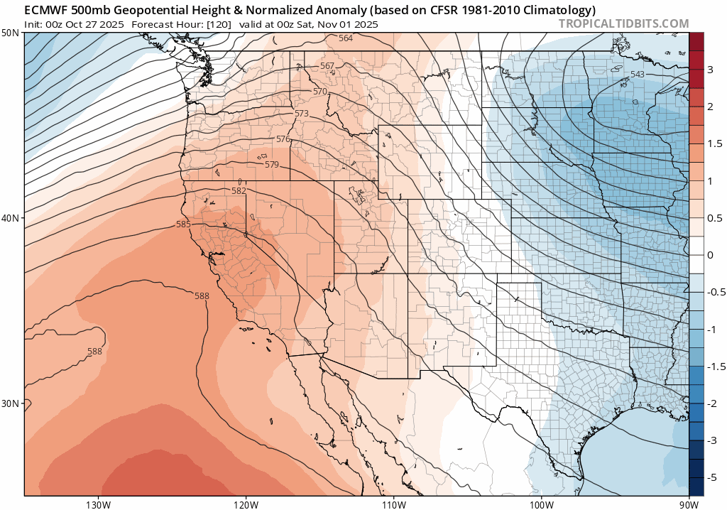
No rain or snow in sight, even well into next week under this warm/dry pattern. Snow enthusiasts will just have to wait a little while longer…
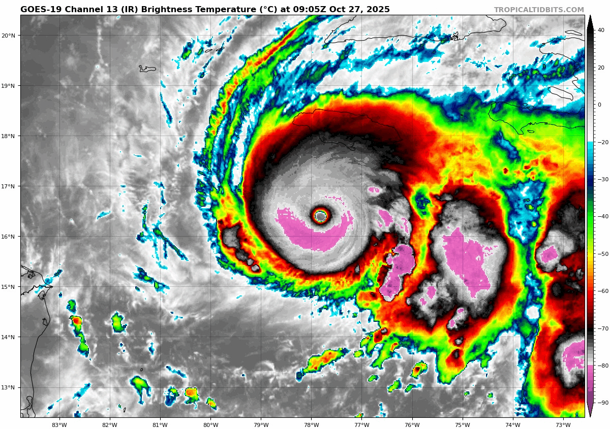
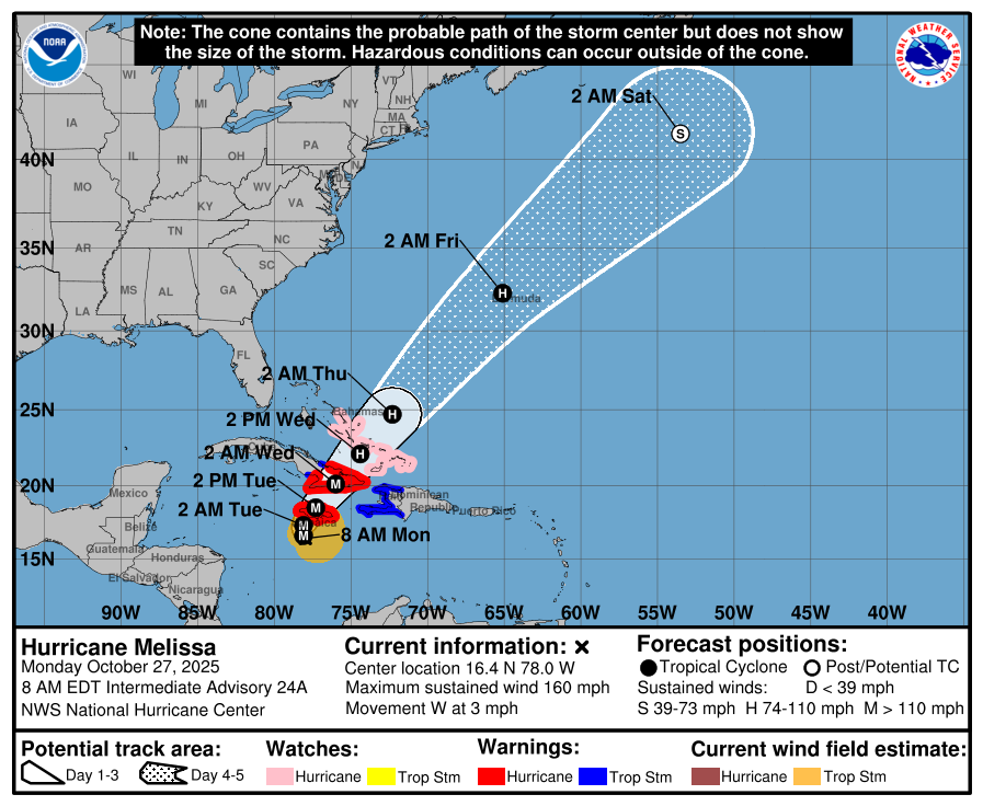
P.S. Keep the residents of Jamaica and Cuba in your thoughts this week as they take a direct hit from Category 5 Hurricane Melissa, likely the strongest hurricane on record ever to directly hit Jamaica. As of Monday morning, Melissa has sustained winds of 160 MPH.
Forecast Specifics:
Monday: Partly sunny and breezy with westerly winds gusting 25 to 35 MPH on the Plains, and 40 to 50 MPH in the Foothills. Highs in the mid 60s for the Plains and mid 40s in the Foothills. Fire danger will be slightly elevated. There will be a chance of a few isolated showers early in the evening mainly east of Denver where a few rumbles of thunder may also occur. Otherwise, winds becoming light overnight with lows in the upper 20s.
Tuesday: Mostly sunny and fairly chilly with mid/upper 40s over the Plains and middle/upper 30s in the Foothills. Gusty winds of up to 25 MPH in the afternoon. Lows Tuesday night very cold in the lower 20s as the entire Front Range experiences a hard freeze.
Wednesday: Sunny and not as chilly but still below normal in the middle 50s on the Plains and lower 40s in the Foothills.
Thursday: Mostly sunny and cool with highs in the middle 50s on the Plains and middle 40s in the Foothills.
Friday: A few clouds. Highs staying below average with middle to upper 50s in the Denver Metro and middle 40s in the Foothills.
Weekend: A warming trend with highs returning above normal is favored, with upper 60s to lower 70s Saturday and Sunday. This warm/dry stretch will continue into next week as well.
DISCLAIMER: This weekly outlook forecast is created Monday morning and covers the entire upcoming week. Accuracy will decrease as the week progresses as this post is NOT updated. To receive daily updated forecasts from our team, among many other perks, subscribe to BoulderCAST Premium.
Go Premium, get all the perks.
Daily Forecast Updates
Get our daily forecast discussion every morning delivered to your inbox.
All Our Model Data
Access to all our Colorado-centric high-resolution weather model graphics. Seriously — every one!
Ski & Hiking Forecasts
6-day forecasts for all the Colorado ski resorts, plus more than 120 hiking trails, including every 14er.
Smoke Forecasts
Wildfire smoke concentration predictions up to 72 hours into the future.
Exclusive Content
Weekend outlooks every Thursday, bonus storm updates, historical data and much more!
No Advertisements
Enjoy ad-free viewing on the entire site.
Enjoy our content? Give it a share!


You must be logged in to post a comment.